
GPS参考资料: https://www.kancloud.cn/alex_wsc/android-wifi-nfc-gps/414158
简介
- 简介
- GPS判断技巧
- AGPS测试_实验室_Lab服务端配置
- AGPS协议组合归类
- AGPS和SUPL关系
- MTK_AGPS_Profiles_XML_配置项
- SUPL_(安全用户面定位)_总体介绍
- Common_AGPS_SUPL分析
- MTK_AGPS_SUPL分析
- Qcom_AGPS_SUPL分析
- SUPL报文参数
- 缩词注释
- AGPS
- Stand Alone
- MSA
- RRLP
- GMLC
- GVC
- MSB
- MOLR
- MOLR设备发起_NILR网络发起_对比
- MOLR_NILR_测试case对比
- SUPL
- SET
- SLP
- SLC
- SPC
- MLS
- SUPL Agent
- SET Initiated SUPL Service
- Network Initiated SUPL Services
- Proxy Mode
- Non-Proxy Mode
- LAC
- LCS
- LPP
- LPPe
- MCC
- MNC
- MNL
- MNLD
- MPE
- MSID
- QoP
- SIP
- SMLC
- V-SLP
- V-SPC
- VTG
- ULP
- UBP
- UE
- UT1_UT2_UT3
- UP_UserPlane
- CP_ControlPlane
- OTDOA
- TBS
- TOA_Time Of Arrive
- PDN
- PVT
- L频段
- 北斗导航频段
- PRN
- AODO
- ECID
- EOTD
- EPO
- QEPO
- 星历_历书
- NI
- SI
- SI_NI的区别
- SAP
- Wiper
- C/A码
- /vendor/etc/gps.conf(Qcom)
- NFW && AFW
- MSISDN
- IMSI
- IMEI
- MSIN
- FQDN
- PLMN
- GNSS
- GPS
- GPS增强系统
- SBAS
- GPST
- IAT
- NTP
- Ephemeris
- Almanac
- AFLT
- DL
- DTM
- DBH
- DOP
- TLS
- TTFF
- NMEA
- FusedLocationProvider && PassiveLocationProvider
- GeofenceManager 地理围栏
- GPS_CAPABILITY_SCHEDULING
- reportSvStatus
- native_set_position_mode设置工作模式
- GpsLocationProvider.java JNI接口
- gps.h::GpsInterface结构体
- NILR
- APN
- GPS缩词统计
- 1 PPM - 1 Pulse Per Minute
- 1 PPS - 1 Pulse Per Second
- 14AF - 14th Air Force, USAF
- 19SOPS
- 1-D - One-dimensional
- 1SOPS
- 2-D - Two Dimensional
- 2DRMS
- 2SOPS
- 3-D - Three Dimensional
- 4-D
- A/C - Aircraft
- A/D - Analog to Digital
- A/J - Anti-Jamming
- AAATS
- ABAS
- ABM - Abeam
- ACI
- ACU - Antenna Control Unit
- ACSM
- A/D - Analog To Digital
- ADC - Analog to digital converter
- ADF - Automatic Direction Finder
- ADI - Attitude Director lndicator
- ADIU - Advanced Digital Interface Unit
- ADP - Automated Data Processing
- ADR - Accumulated Delta Range
- ADS
- AE - Antenna Electronics
- AECB - Atomic Energy Control Board
- AF - Air Force
- AFB - Air Force Base
- AFI - Automatic Fault Indication
- AFSPC - Air Force Space Command
- AGL - Above Ground Level
- AHRS
- AI - Artificial Intelligence
- AIAA
- AIS - Automated Information System
- AJ - Antijamming
- ALT - Alternate
- ALT - Altitude
- AM - Amplitude Modulation
- AM/FM
- AMCS - Alternate Master Control Station
- ANE - Autonomous Navigation Emulator
- ANSI
- ANTB - Advanced Navigation Test Bed
- AoA - Analysis of Alternatives
- AOA - Airport Operations Area
- AOA - Angle-of-Attack
- AOC - Aeronautical Operation Control
- AOC - Auxiliary Output Chip
- AOC - Auxiliary Output Chip
- AOCS - Attitude and Orbit Control System
- AOM - Aircraft Operating Manual
- AOO - Area of Operations
- AOPA
- AOR - Area of responsibility
- AORP
- AP - Acquisition Plan
- APA - Airline Pilots Association
- APMS
- APPR - Approach/Approach Mode
- APPS
- APR - April
- APU - Auxiliary Power Unit
- AQP - Advanced Qualification Program
- ARGO - Automatic Ranging Grid Overlay
- ARNS - Aeronautical Radio Navigation Service
- ARPA - Advanced Research Projects Agency
- ARR - Arrival
- ARTCC - Air Route Traffic Control Center
- ARTS - Automated Remote Tracking Station
- ARTS - Automated Radar Terminal System
- AS - AntiSpoofing
- ASCII
- ASF - Additional Secondary Factor (Loran-C)
- ASI - Air Speed Indicator
- ASIC - - Application Specific Integrated Circuit
- ASPRS
- ASR - Airport Surveillance Radar
- ATA - Air Transport Association
- ATC - Air Traffic Control
- ATCS - Advanced Train Control Systems
- ATCSCC
- ATE - Automatic Test Equipment
- ATM - Air Transportation Management
- ATON - Aids To Navigation
- ATS - Automatic Throttle System
- AUG - August
- Autonav - Autonomous Navigation
- AVAIL - Available
- AVL - Automatic Vehicle Location
- AVL - Automatic Vehicle Location -
- AVLN
- Civic Address
- AVM - Automatic Vehicle Monitoring
- AWACS - Airborne Warning And Control System
- AWAS - Automated Weather Advisory Station
- AWIPS
- B - Billion
- BBS - Bulletin Board Service
- BCD - Binary Code Decimal
- BER - Bit Error Rate
- BIPM
- BITE - Built-in Test Equipment
- BMCS
- Bps - Bits per second
- BPSK - Binary Phase Shift Keying
- BRG - Bearing
- BRT - Brightness
- BUMCS - Back-up Master Control Station
- C - Centigrade
- C&A - Certification and Accreditation
- C/A - Coarse Acquisition Code
- C/No - Carrier to Noise Ratio
- C/PD - Cost/Pricing Data
- C2 - Command and Control
- C3 - Command, Control, and Communications
- C3I
- CAD - Computer Aided Design
- CASE - Computer Aided Software Engineering
- CAT - Computer Aided Testing
- CBD - Commerce Business Daily
- CBT - Computer Based Training
- CCB - Configuration Control Board
- CCW - Continuous carrier wave
- CCW - Coded Continuous Wave
- CCZ - Coastal And Confluence Zone
- CDMA - Code Division Multiple Access
- CDU - Control Display Unit
- CDMA
- CEP - Circular error probable
- CG - Center of Gravity
- CGS - Centimeter-gram-second
- Cl - Cost Index
- CLR - Clear
- cm - Centimeter
- CM - Configuration Management
- CMG - Command Managers Guide
- CMOS - Complementary Metal Oxide Semiconductor
- CMC - Central Maintenance Computer
- CMP - Configuration Management Plan
- CMS - Command Management Seminar
- CNA - Computer Network Attack
- CNS -
- CO
- COE
- CONOPS - Concept of Operations
- COP - Circle Of Position
- CONUS - Continental United States
- CORS -
- COTS - Commercial Off-The-Shelf
- CPU - Central Processing Unit
- CRPA - Controlled Radiation Pattern Antenna
- CRT - Cathode Ray Tube
- CRYPTO - cryptographic
- CS - Control Segment
- CTR - Center
- CSAT - Constellation System Assessment Team
- CTRL - Control
- CTS - Colorado Tracking Station
- CUE - Common User Element
- CVNS - carrier navigation systems
- CW - Continuous Wave
- CY - Calendar Year
- D/A - Digital To Analog
- D/D - Drift Down
- DAC - Digital to Analog Converter
- DATALINK
- dB - Decibel (X = 10 Log X dB)
- DBS - Direct Broadcast Satellite
- dBW - decibels per watt
- DC - Direct Current Electricity
- DEC - December
- DECR - Decrement
- DEG - degree
- DEL - Delete
- DEP - Departure
- DEV - Deviation
- DF - direction finding
- DGIC - Differential GPS Integrity Channel
- DGNS - Doppler GPS Navigation System
- DGPS
- DH - Decision Height
- DID - Data Item Description
- DIS - Distance
- DISCR - Discrepancy
- DIST - Distance
- DLL - Delay Lock Loop
- DLM - Data Loader Module
- DLR - Data Loader Receptable
- DLS - Data Loader System
- DLT - Data Link Terminal
- DMA - Defense Mapping Agency
- DME - Distance Measuring Equipment
- DMU - Data Management Unit
- DoD - Department Of Defense
- DOE - Department of Energy
- DOP - Dilution Of Precision
- DoT - Department Of Transportation
- DR - Dead Reckoning
- DRMS - Distance Root Mean Square
- DRS - Dead Reckoning System
- DRU - Data Retrival Unit
- DT&E - Development Test and Evaluation
- DTG - Distance-to-go
- E - East
- EA
- ECDIS
- ECEF - Earth Centered, Earth Fixed
- EDM - Electronic Distance Measurement
- EGNOS - European Geostationary Navigation Overlay Service
- EOS - Earth Orbiting System
- EPROM - Erasable Programmable Read-Only Memory
- EHF - Extremely High Frequency
- ETA - Estimated Time Of Arrival
- ECE - Earth-Centered-Earth-Fixed
- ECEF - Earth Centered, Earth Fixed
- ECM - Electronic Countermeasures
- ECP - Engineering Change Proposal
- ECS - Environmental Control System
- EDM - Electronic Distance Measurement
- EFIS - Electronic Flight Instrument System
- EHF - Extremely High Frequency
- EHSI
- EIU - Electronic Interface Unit
- EKMS - Electronic Key Management System
- ELEV - Elevation
- ELT - Emergency Locator Transmitter
- EM - Electro Magnetic
- EMC - Electromagnetic Compatibility
- EMCON - Emission Control
- EMI - Electromagnetic Interference
- EMP - Electromagnetic Pulse
- EMS - Emergency Medical Services
- ENG - Engine
- EOL - End of Life
- EOW - End of Week
- EPR - Engine Pressure Ratio
- EPROM
- EPS - Electric Power System
- ES - Electronic Support
- ESGN - Electrically Suspended Gyro Navigator
- ESM - Electronic Support Measures
- EST - Estimated
- ETA - Estimated Time of Arrival
- ETX - End of Transmission
- EU - European Union
- EW - Electronic Warfare
- EXEC - Execute
- Exp - Exponential Function
- F - Fahrenheit
- f - Frequency
- FAA - Federal Aviation Administration
- FAATC
- FADEC - Full Authority Digital Engine Control
- FANS - Future Air Navigation Systems
- FAR - Federal Acquisition Regulation
- FBO - Fixed Based Operator
- FCC - Federal Communications Commission
- FCC - Flight Control Computer
- FCMDR - Flight Commander
- FCU - Flight Control Unit
- FD - Fault Detection
- FDE
- FDMA - Frequency Division Multiple Access -
- FDR - Flight Data Recorder
- FEB - February
- FHWA - Federal Highway Administration
- FLT - Flight
- FI - Fault Isolation
- FL - Florida
- FM - Frequency Modulation
- FMEA Failure Mode and Effects Analysis
- FMS - Flight Management Systems
- FO - First officer
- FOC - Full Operational Capability
- FOM - - Figure Of Merit
- FOIA - Freedom of Information Act
- FOUO - For Official Use Only
- FPA - Focal Plane Array
- FPM - Feet Per Minute
- FQIS - Fuel Quantity Indicating System
- FR - From
- FRA - Federal Railroad Administration
- FRA - Flap Retraction Altitude
- FREQ - Frequency
- FRP - Federal Radionavigation Plan
- FRPA - Fixed Radiation Pattern Antenna
- FRPA-GP - FRPA Ground Plane
- FSS - Federal Supply Schedule
- FT - Feet
- FY - fiscal year
- GA - General Aviation
- GA - Ground Antenna
- GANS - global access, navigation and safety
- GAO - General Accounting Office
- GATM - Global Air Traffic Management
- GBAS - Ground-based augmentation system
- Gbps - Gigabits per second
- GDOP - Geometric Dilution Of Precision
- GEO - Geosynchronous Earth Orbit
- GEOREF - World Geographic Reference System
- GHz - Gigahertz
- GIAC - GPS Interagency Advisory Council
- GIB - GPS Integrity Broadcast
- GIC - GPS Integrity Channel
- GIS - Geographic Information Systems
- GLONASS - Global Navigation Satellite System
- GMT - Greenwich Mean Time
- GNSS - Global Navigation Satellite Systems
- GPS - Global Positioning System
- GPSE - GPS Enhancement
- GPSIC - GPS Information Center
- GRAS - Ground-based regional augmentation system
- GRP - Geographical Reference Points
- GRS - Geodetic Reference System
- GTP
- GS - Glide Slope
- GS - Ground Speed
- GSA - General Services Administration
- GW - Gross Weight
- GYRO - gyroscope
- GSV
- GNS
- GGA
- GLL
- HADGPS - High Accuracy DGPS
- HANU - High Accuracy Navigational Users
- HD - High dynamic
- HDG - Heading
- HDG - SEL - Heading Select
- HDOP - Horizontal Dilution of Precision
- HF - High Frequency
- HHA - Harbor And Harbor Approach
- HF - high frequency
- HIRS - High-Resolution Infrared Sounder
- HMI - Hazardously Misleading Information
- HR - relative height
- HUD - Head-Up Display
- HV - Host Vehicle
- Hz - Hertz (cycles per second)
- IALA
- ICAO - International Civil Aviation Organization
- ICD - Interface Control Document
- ICS - Interim Control Segment
- ID - Identifier
- ICWG - Interface Control Working Group
- IDD - Interface Design Document
- IEEE
- IERS - International Earth Rotation Service
- IF - Intermediate Frequency
- IFF - Identification Friend or Foe
- IFR - Instrument Flight Rules
- IF - Intermediate Frequency
- IGEB - Interagency GPS Executive Board
- IG - Inspector General
- IGS - International GNSS Service
- ILS - Instrument Landing System
- IMO - International Maritime Organization
- INFO - Information
- IFRB - International Frequency Registration Board
- INIT - Initialization
- INMARSAT - International Maritime Satellite
- INR - Image Navigation and Registration
- INS - Inertial Navigation System
- INTC - Intercept
- IOC - Initial Operational Capability
- ION - Institute Of Navigation
- IOT&E - Initial Operational Test and Evaluation
- IP - Instrumentation Port
- IPT - Integrated Product Team
- IRD - Interface Requirements Document
- IRS - Inertial Reference System
- IRT - Independent Review Team
- IRU - Inertial Reference Unit
- ISA - International Standard Atmosphere
- ISO - International Standards Organization
- ITP - Integrated Test Plan
- ITRF - International Terrestrial Reference Frame
- ITS - Intelligent Transportation System
- ITU - International Telecommunication Union
- IV&V
- IVHS
- J/S - Jamming to Signal Ration
- JAN - January
- JCS - Joint Chiefs of Staff
- JPALS -
- JPL - Jet Propulsion Laboratory
- JPO - Joint Program Office
- JROC
- JSRA - Joint Sponsored Research Agreement
- JSST - J oint Space Support Team
- JSTARS
- JTF - Joint Task Force
- JTIDS
- JUL - July
- JUN - June
- K - Thousand
- Kbps - Kilo bits per second
- KG - Kilogram
- kHz - kilohertz
- KHz - Kilohertz
- km - Kilometer
- KT - (kts) - Knots
- kW - Kilowatt
- L - Link
- L - Left
- L1 - GPS Carrier Frequency, 1575.42 MHz
- L2 - GPS Carrier Frequency, 1227.6 MHz
- LAAS - Local Area Augmentation System
- LAN - Local Area Network
- Lat - Latitude
- Lat/Lon - Latitude/Longitude
- LBS - L Band System
- L2C - Civil signal on L2
- L2M - Military-code on L2
- L5 - Link 5, carrier frequency = 1176.45 MHz
- LAAFB - Los Angeles Air Force Base
- LAAS - Local Area Augmentation System
- LAN - Local Area Network
- LAT - latitude
- LCD - Liquid Crystal Display
- LCN - Local Communications Network.
- LED - Light Emitting Diode
- LEO - Low Earth Orbit
- LEP - Linear Error Probable
- LED - Light emitting diodes
- LEO - Low Earth Orbit
- LEP - linear error probable
- LF - low frequency
- LFR - Low-frequency Radio Range
- LIM - Limit
- LIS - Land Information System
- LF - Low Frequency
- LO - Local Oscillator
- LO - Low
- LOC - Localizer Beam
- Lon - Longitude
- LOP - Line Of Position
- Loran - Long Range Navigation
- LOS - Line Of Sight
- LRC - Long Range Cruise
- LRU - Line Replaceable Unit
- M - Mach Number
- m - Meter(s)
- M - Million
- M/S - Meters per Second
- MAG - Magnetic
- MAINT - Maintenance
- MAN - Manual
- MAR - March
- MAX - Maximum
- mB - Millibar
- Mbps - Mega bits per second
- MC&G - mapping, charting, and geodesy
- MCA - Minimum Crossing Altitude
- MCDU - Multipurpose Control Display Unit
- M-Code - Military Code
- MCS - Master Control Station
- MCT - Mean Corrective Maintenance Time
- MCW - Modulated Continuous Wave
- MCW - modulated continuous wave
- MD - Maryland
- MDL - Multipurpose Data Link
- MEL - Minimum Equipment List
- MF - Medium Frequency
- MGRS - Military Grid Reference System
- MHz - Megahertz
- MIDAS - Multi-discipline Data Analysis System
- mil
- MILSPEC - Military Specifications
- MIN - Minimum
- MIN - Minutes
- MLRS - multiple launch rocket system
- MLS - Microwave Landing System
- MLV - Medium Launch Vehicle
- mm - millimeter
- MMD - Mean Mission Duration
- MMR - Multi-Mode Receiver
- MN - Magnetic North
- MNP - Master Navigation Plan
- MNS - Mission Need Statement
- MOA - Memorandum of Agreement
- MOD - Modified/Modification
- MODIS - Moderate-resolution Imaging Spectrometer
- MOPS - Minimum Operational Performance Standards
- MOU - Memorandum of Understanding
- MP - Master Plan
- MS - Monitor Station
- MSAS - MTSAT Augmentation System
- MSG - Message
- MSK - Minimum Shift Keying
- MSS - Mobile Satellite Service
- MSL - Mean Sea Level
- MTBF - Mean Time Between Failures
- MTSAT - Multifunction Transport Satellite
- MU - Management Unit
- MWP - Meteorological Weather Processor
- N - North
- N/A - Not Applicable
- NACA
- NAD - North American Datum -
- NADU - Notice Advisory to DGPS Users
- NAGU - Notice Advisory to Glonass Users
- NANU - Notice Advisory to Navstar Users
- NAS消息
- NAS - National Aircraft Standard
- NAS - National Airspace System
- NASA -
- NATCA -
- NATO - North Atlantic Treaty Organization
- NAV - Navigation
- NAVAID - Navigational Aid
- NAV-msg - . - Navigation Message
- NAVSTAR
- Navwar - Navigation Warfare
- NCA - National Command Authority
- ND - Navigation Display
- NDB - Nondirectional Radio Beacon
- NDGPS
- NDS Nuclear Detection Subsystem
- NESDIS
- NGS - National Geodetic Survey
- NIMA
- NIST
- Nl - Engine Revolutions per Minute (percent)
- NLM - Network Loadable Module
- NLR
- NM - Nautical Mile
- Nm - Nautical Mile
- NMC - National Meteorological Center
- NNSS
- NOAA -
- NOS - National Ocean Survey
- NRL - Naval Research Laboratory
- Ns - Nanosecond
- NOAA
- NOCC - National Operations Command Center (FAA)
- NORAD - North American Aerospace Defense Command
- NOTAM - Notice for Airman
- NOV - November
- NPA - Non-precision approach
- NRL - Naval Research Laboratory
- NRP - National Route Program
- NS - Nanosecond
- NSC - Non-standard C/A code
- NSC - National Security Council
- NSTC
- NTIS
- NTS - Navigation Technology Satellite
- NTSB - National Transportation Safety Board
- NW - Northwest Airlines
- NWS - National Weather Service
- OAB - Operational Advisory Broadcasts
- OATS - Orbit and Attitude Tracking
- OBE - Overtaken by Events
- OBS - Omni Bearing Select
- OCONUS
- OCS - Operational Control Segment
- OEM - Original Equipment Manufacturer
- OGE - Operational Ground Equipment
- OIS - Orbital Insertion System
- OJT - On-the-Job Training
- OMB - Office of Management and Budget
- ONC - operational navigation chart
- OP - Operational
- OPCON - operational control
- OPSCAP - Operational Status Capability
- OPT - Optimum
- ORD - Operational Requirements Document
- ORRB - Operational Requirements Review Board
- ORWG - Operational Requirements Working Group
- OS - Operational Stability
- OSCARS
- OSD - Office of the Secretary of Defense
- P-Code - Precision/Protected Code
- PADS - Position Azimuth Determining System
- PAFB - Peterson Air Force Base, Colorado Springs, CO
- PALS - Precision Approach Landing System
- PC - Personal Computer
- PDD - Presidential Decision Directive
- PDOP - Position Dilution Of Precision
- PE - Probable error
- PERF - Performance
- PHARE
- PHIBUF - Performance Buffet Limit
- PHMI
- PHINOM - Nominal Bank Angle
- PINS - Precise Integrated Navigation System
- PLGR - Precise Lightweight GPS Receiver
- PMI - Preventative Maintenance Instructions
- PMS - Performance Management System
- PNT - Position, navigation and time
- POC - Point of Contact
- POS - Position
- POS REF - Position Reference
- Pos/Nav - positioning/navigation
- PPM - Parts Per Million
- PPM - Parts Per Million
- PPOS - Present Position
- PPS - Precise Positioning Service
- PPS - Pulse Per Second
- PR - Pseudorange
- PREV - Previous
- PRN - Pseudo Random Noise
- PROM - Programmable Read-Only Memory
- PTTI - precise time and time interval
- PY - Prior Year
- PDR
- QA - Quality Assurance
- QC - Quality Control
- QTY - Quantity
- QUAD - Quadrant
- R - Right
- R&D - Research and Development
- RAD - Radial
- RAIM - Receiver Autonomous Integrity Monitoring
- RAM - Random Access Memory
- RAP - Reserve Auxiliary Payload
- RCVR - Receiver
- RDF - Radio Direction Finder
- RDOP - Relative Dilution of Precision
- RDSS - Radio Determination Satellite Systems
- REF - Reference
- RF - Radio Frequency
- RFI - Radio Frequency Interference
- RINEX - Receiver INdependent EXchange format
- RLG - ring laser gyro
- RMS - Root Mean Square
- RNAV - Area Navigation
- RNP - Required Navigation Performance
- ROM - Read-Only Memory
- ROV - Remotely Operated Vehicle
- RTCA - Radio Technical Commission for Aeronautics
- RTCA-SC
- RTCM - Radio Technical Commission for Maritime Services
- RTK - Real-Time Kinematic
- RSS - Root Sum Square
- RTCA
- RTCM
- RTE - Route
- RTS - Remote Tracking Station
- RVR - Runway Visual Range
- RMC
- S - South
- S/A - Selective Availability
- SA - Selective Availability
- SA - Situation Awareness
- SA/A-S - selective availability/anti-spoof
- SAASM
- SAFB
- SAR
- SARPS - Standards and Recommended Practices
- SATCOM - Satellite Communications
- SATNAV - Satellite Navigation
- SBIR
- SC - Special Committee
- SCA
- SCAT I - Special Category I
- SCATANA
- SCCB - Software Configuration Control Board
- SCI - Sensitive Compartmented Information
- SCSS - Satellite Control Simulation System
- SDLS - Satellite Data Link Standard
- SE - Systems Engineering; Support Equipment
- sec - Second(s)
- SEL - Selected
- SEP - - Spherical Error Probable
- SES - Severely Errored Seconds
- SF - Sub Frame
- SGLS - Space-Ground Link Subsystem
- SHF - Super High Frequency
- SIGMET
- SIGSEC - Signal Security
- SINS - Shipborne INS
- SIS - Signal-In-Space
- SKYNET - Skynet Communications Satellite
- SLEP - Service Life Extension Program
- SLR - Satellite Laser Ranging
- SLS - Satellite Launch Squadron
- SM - Security Module
- SME - Subject Matter Experts
- SNAPM
- SNR - Signal To Noise Ratio
- SOC - Satellite Operations Center
- SOIT
- SONAR - sound navigation ranging
- SOP - Standard Operating Procedure
- SOPS
- SORD
- SP - Space
- SPS - Standard Positioning Service
- SPU - Spacecraft Processor Unit
- SQL - Structured Query Language
- SRP - Selected Reference Point
- SS - Space Segment
- SSG - Senior Steering Group
- SSM - Sign Status Matrix
- SSN - Space surveillance network
- SPS - Standard Positioning Service
- STB - System Test Bed
- STD - Standard
- STS-Space Transportation System
- STS
- STS/TSM
- SV - Space Vehicle
- SVN
- T - Trillion; Time
- T&E - Test and Evaluation
- TACAN - Tactical Air Navigation
- TAI - International Atomic Time
- TBD - To Be Determined
- TCA - Terminal Control Area
- TCAS
- TD - Time Difference
- TDMA - Time Division Multiple Access
- TDOP - Time Dilution of Precision
- TE - Test Equipment
- TEMP - Temperature
- THDG - True Heading
- TN - True North
- TO T - echnical Order
- TOA - Time of Arrival
- TOD - Time Of Day
- TOPEX - The Ocean Topography Experiment
- TOT - Total
- TQM - Total Quality Management
- TRACON
- TRANS - Transition
- TSO - Technical Standard Order
- UAV - Unmanned Aerial Vehicle
- UE - User Equipment
- UERE - User Equivalent Range Error
- UEE - User Equipment Error
- UHF - Ultra High Frequency
- UNK - Unknown(s)
- URE - User Range Error
- US - User Segment
- USAF - United States Air Force
- USCG - United States Coast Guard
- USGIC - US GPS Industry Council
- USGS - US Geological Survey
- USNO - US Naval Observatory
- UT - Universal Time
- UTC - Coordinated Universal Time
- UTC (USNO)
- V - Velocity
- V&V - Verification and Validation
- VAR - Variation
- VAR - Visual-aural Radio Range
- VDOP - Vertical Dilution of Precision
- VE - Value Engineering
- VFR - Visual Flight Rules
- VHF - Very-high Frequency
- VLF - very low frequency
- VLM - Vehicle Location Monitoring
- VMC - Visual Meteorological Conditions
- VNAV - Vertical
- VOM - Volt-ohm-milliammeter
- VOR
- VOR/DME
- VORTAC
- VPATH - Vertical Path
- VREF - Reference Velocity
- VTC - Vessel Traffic Center
- VTOL - Vertical Takeoff and Landing
- VTR - Variable Takeoff Rating
- VTS - Vessel Traffic Services
- W - West
- WAAS - Wide Area Augmentation System
- WADGPS - Wide Area Differential GPS
- WAGE - Wide Area GPS Enhancement
- WAN - Wide Area Network
- Waypoint
- WGS - World Geodetic System
- WGS 84 - World Geodetic System 1984
- WPT - Way point
- WRC - World Radio Conference
- WT - Weight
- WWV WWVH - time station call letters
- WX - Weather
- WXR - Weather Radar
- X-BAND
- XCVR - Transceiver
- XFR - Transfer
- XLTR - Translator
- XMIT - Transmit
- XMITR - Transmitter
- Y code - Precise code (GPS)
- Y2K - Year 2000
- YD - Yaw Damper
- YSAS - Yaw Stability Augmentation System
- Z - Zulu (GMT time)
- ZDA
- zukgit_check_agps_profiles_conf2
- GPS问题列表
GPS判断技巧
GPS Lab SUPL测试无信号回复
请检查测试设置(确保射频电缆已正确连接到 GPS 端口),然后在 TE 侧将 GPS 发射功率提高 15 分贝,之后再进行测试。

please check test setup ( make sure RF cable was connected to GPS port properly ) and increase GPS TX power by 15db on TE side then re-test it
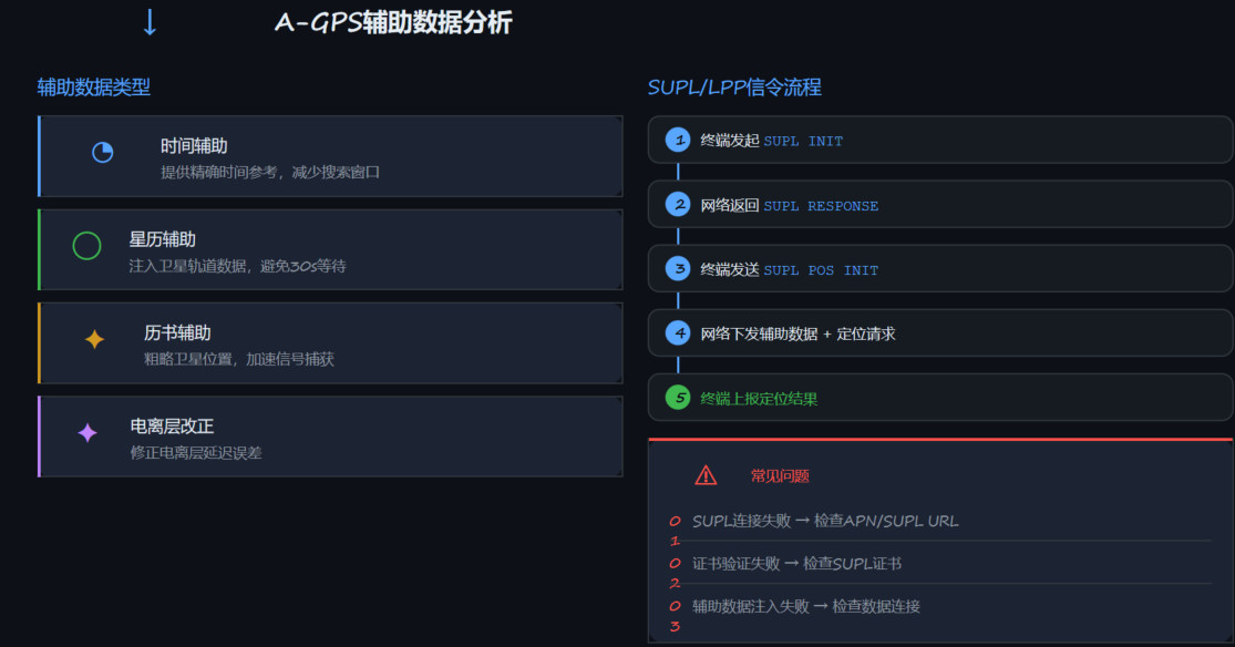
AGPS辅助数据
1.时间辅助:  提供精确时间参考,减少搜索窗口
2.星历辅助_Ephemeris:  注入卫星轨道数据,避免30s等待
3.历书辅助_Almanac  :  粗略卫星位置,加速信号捕获
4.电离层改正: 修正电离层延迟误差


- 四种辅助数据分别解决不同问题,星历辅助对TTFF影响最大
- SUPL流程5步完整走通才算成功,任何一步失败需排查
- 0x147F日志可确认辅助数据请求是否发出
- SUPL连接失败最常见,优先检查APN和服务器地址
- 证书问题在特定运营商网络中容易复现
MTK_判断GPS使用什么晶振类型clock_type以及是否有做过校准
1.启动GPS并录制GPS Host Log。
2.打开录制的GPS Host Log,搜索包含如下格式的语句:
---------------------------------------
PMTK013,33,【ClkType,**254**】,【C0,1.084043】,【C1,-0.270325】,k,1*2E
其中,ClkType的值代表时钟类型:
co-TMS:是协同温度补偿晶体(Coordinated Temperature Compensated Crystal)的缩写,是联发科(MTK)平台对其手机芯片系统中用于提供高精度时钟信号的 TCXO 组件的特定称呼。
TCXO:全称为温度补偿晶体振荡器(Temperature Compensated Crystal Oscillator)。它是一种通过内置温度补偿电路来减少环境温度变化对振荡频率影响的石英晶体振荡器。
其核心原理是利用温度传感器监测环境温度,并通过补偿电路调整振荡参数,以抵消温度引起的频率漂移,从而在工作温度范围内保持高度稳定的输出频率。
254 表示 co-TMS
255 表示 TCXO
观察日志中C0和C1的数值:
如果【C0和C1不为0且不等于-0.225】,说明测试机器已经做过产线校准。
如果【C0和C1为0或-0.225,则可能未做过校准】
---------------------------------------
$HBD,0,IF1,TMS,PMTK013,12,【ClkType,254】,【C0,-0.206388】,【C1,-0.208724】,k,1*0
$HBD,0,IF1,TMS,PMTK013,11,【ClkType,254】,【C0,-0.206388】,【C1,-0.208724】,k,1*0E
$HBD,0,IF1,TMS,PMTK013,21,【ClkType,254】,【C0,-0.206388】,【C1,-0.208724】,k,1*0D
$HBD,0,IF1,TMS,PMTK013,22,【ClkType,254】,【C0,-0.206388】,【C1,-0.208724】,k,1*0E
MTK_如何判断测试机GNSS启动方式
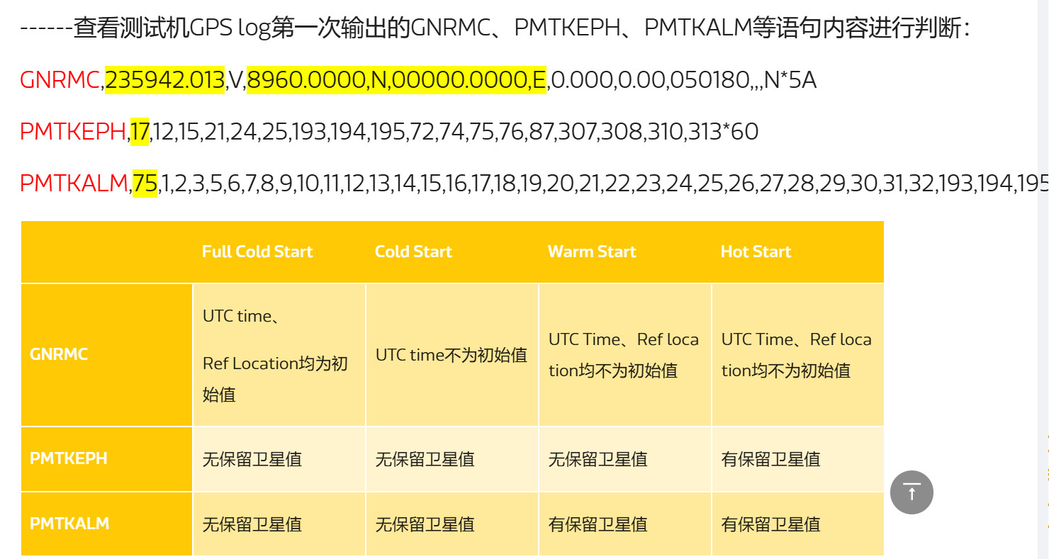
------查看测试机GPS log第一次输出的GNRMC、PMTKEPH、PMTKALM等语句内容进行判断:

GNRMC,【235942.013,V】,【8960.0000,N】,【00000.0000,E】,0.000,0.00,050180,,,N*5A


Ephemeris  星历表 星历表包含了非常详细的卫星轨道和位置信息,所以其数据量较大,传输时间较长, 有效期为【3】到【4】小时
PMTKEPH,【17 (17个星历卫星编号)】,12,15,21,24,25,193,194,195,72,74,75,76,87,307,308,310,313*60  【PMTKEPH 星历卫星编号】


Almanac 历书也包含了卫星的位置等相关信息,不过它是星历数据的简化集,其精度较低。所以,历书数据量较小,传输时间较短 , (不超过180天)
PMTKALM,【75 (75个历书卫星编号)】,1,2,3,5,6,7,8,9,10,11,12,13,14,15,16,17,18,19,20,21,22,23,24,25,26,27,28,29,30,31,32,193,194,195,65,66,67,68,69,70,71,72,73,74,75,76,77,78,79,80,81,82,83,84,85,86,87,88,301,302,303,304,305,306,307,308,309,310,311,312,313,314,316,317,319*43


【GPRMC】
【GNRMC】
$GPRMC和$GNRMC是两种不同的NMEA 0183语句格式,用于GPS定位信息的传输。
$GPRMC 是 Global Positioning Recommended Minimum Specific GNSS Data的缩写,是一种常见的GPS定位信息语句。它包含了位置、速度、航向等信息。其中,G表示GPS定位系统,RMC表示推荐的最小定位数据。

$GNRMC 是GNSS (Global Navigation Satellite System) Recommended Minimum Specific GNSS Data的缩写,是一种更通用的定位信息语句。它与$GPRMC类似,也包含了位置、速度、航向等信息。其中,GN表示全球导航卫星系统,RMC表示推荐的最小定位数据。


区别
$GPRMC是专门用于GPS【定位】系统的语句,
$GNRMC是更通用的全球【导航】卫星系统的语句,可以适用于其他导航卫星系统,如GLONASS、Galileo等。在实际应用中,$GNRMC 更常见,因为它可以适用于多种导航卫星系统的定位信息传输。


例子:
$GPRMC,232703.917,V,4739.7687,N,12206.0265,W,0.000,0.00,180523,,,N,V*2A

$GNRMC,235942.012,V,8960.0000,N,00000.0000,E,0.000,0.00,050180,,,N,V*21   【最小导航推荐】
$PMTKEPH,11,2,5,10,13,15,16,18,23,26,27,29*5A
$PMTKALM,2,3,26*6B
冷启动模式(也叫出厂模式):
         在这种模式下,GPS接收器没有保存有效星历、时间及位置等信息,
		 所以它需要从周围可搜索到的GPS卫星那接收信号并获取用于定位的数据(星历、历书、时间等信息)。
		 前面曾介绍,传输一个完整的GPS导航电文需要12.5分钟。在这种模式下,TTFF至少为12.5分钟。


暖启动模式:
           在这种模式下,GPS接收器保存有历书数据(不超过180天)、旧时间信息(不超过20秒)及旧位置信息(不超过100千米范围),
		   但星历数据失效(超过4小时)。如此,在计算位置时,GPS接收机需要从GPS卫星那接收星历数据
		   (读者还记得吗,导航电文的25个帧中第2、3子帧包含发送卫星的星历数据,
		   由于每一帧发送时间为30秒,所以星历数据每隔30秒就会更新一次)。所以,在这种模式下,TTFF至少为30秒。


热启动模式:
          在这种模式下,GPS接收机具有有效星历数据、时间及位置等信息,
		  这样,GPS接收器就无须解码GPS导航电文中的星历数据,它只要利用GPS信号进行测距计算就可以了。
		  热启动模式下,TTFF速度很快,能做到10秒以内。
判断卫星信号质量db质量
C/N0 (载噪比) 质量评估标准
【C/N0 范围】                【信号质量】        【定位能力】
> 40 dB-Hz	                  优秀	              可用于高精度定位
35-40 dB-Hz	                  良好	              正常定位
30-35 dB-Hz	                  可接受              基本定位
25-30 dB-Hz	                  较弱	              可能影响定位
< 25 dB-Hz	                  很弱	              通常无法使用
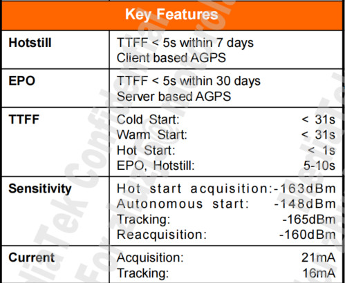
TTFF 参考标准
TTFF 参考标准

启动类型	正常范围	异常阈值
冷启动	    30-60s	    >90s 异常
温启动	    10-30s	    >45s 异常
热启动	    1-5s	    >10s 异常
A-GPS	    1-10s	    >20s 异常
MTK查看MPE生效情况
MTK 文档: https://online.mediatek.com/apps/faq/detail?faqid=FAQ39407&list=SW

1. 查看 mpe.conf 查看配置情况
adb root && adb shell " cat  /vendor/etc/mpe.conf "


mpe_enable=1   【MPE总开关】 需要设置为1
print_rawdata=0
auto_calib=0
indoor_enable=1    //UDR在indoor环境中是否使能 需要设置为1
udr_enable=1  【Untethered Dead Reckoning】主要指【车载场景 UDR 下的惯导算法 】 需要设置为1   udr开关
pdr_enable=1  【Pedestrian Dead Reckoning】主要指【行人场景 PDR下的惯导算法  】 需要设置为1   pdr开关
mpe_sensor=1 //sensor厂商(1:BOSCH,2:ST,3:InvenSense)

2、通过main log中查找UDR version或PDR version关键字,查看UDR/PDR版号及enable状况。 以及 sensor params 查看 sensor 是否正常

    27192 07-18 09:09:19.552780 889 1876 I MTK_SF_LIB: [pdr_info] PDR: PDR version: PDR_v1.4.2,2019_11_22, enable: 32 //enable值≥32表示PDR enable
    27203 07-18 09:09:19.552919 889 1876 I MTK_SF_LIB: [udr_info] UDR: UDR version: UDR_v3.4.3,2020_01_03, enable: 16 //enable值≥16表示UDR enable
    27182 07-18 09:09:19.552598 889 1876 D MTK_SF_LIB: [sf_debug] ConfigParams: [sensor params] acc_dr(50), 【acc_id(5)】, gyro_dr(50), 【gyro_id(6)】, mag_dr(5), mag_id(11)


3, 查看 使用cmd查询当前手机的sensor信息:adb shell dumpsys sensorservice


adb shell dumpsys sensorservice | grep -e _acc   -e _gyro

0x00000001) lsm6dso_acc               | st              | ver: 1 | type: android.sensor.accelerometer(1) | perm: n/a | flags: 0x00000000
0x00000004) lsm6dso_gyro              | st              | ver: 1 | type: android.sensor.gyroscope(4) | perm: n/a | flags: 0x00000000
0x0000000a) linear_acc                | mtk             | ver: 1 | type: android.sensor.linear_acceleration(10) | perm: n/a | flags: 0x00000000
0x00000010) uncali_gyro               | mtk             | ver: 1 | type: android.sensor.gyroscope_uncalibrated(16) | perm: n/a | flags: 0x00000000
0x00000023) uncali_acc                | mtk             | ver: 1 | type: android.sensor.accelerometer_uncalibrated(35) | perm: n/a | flags: 0x00000000
0x5f6c696e) Linear Acceleration Sensor | AOSP            | ver: 3 | type: android.sensor.linear_acceleration(10) | perm: n/a | flags: 0x00000000


4、确认系统时间是否有校准成功(从包含开启GPS的mobile log中确认):
快捷的方式是可以通过gps debug log(nmea log)目录下是否生成se_utxxx.txt sensor文件,有该文件则说明时间校准满足测试要求。

通过main log检索关键字 global_gps_diff,该值需要小于3600sec(即小于1小时)才认为满足MPE触发条件。
12-27 13:12:52.819070  1752  1794 D MPE_SE  : mpe_sensor_check_time_diff: SE sensor run source, mnl_inject_gps_time: 1766812389, mnl_inject_sys_time: 1766812390.819021, global_gps_diff =1.819021
MTK 文档: https://online.mediatek.com/apps/faq/detail?faqid=FAQ39407&list=SW


MPE生效确认:
MPE生效与否需要检查gps debug log,即后缀为.nma的文件:

搜索字段PMTKMPE1确认MPE生效状态:

$PMTKMPE1,497.4,0.942,22.5049131,113.9393580,-4.36,0.15,-1.02,0.26,-0.17,-1.42,-89.22,0.00,【6,3,9,1*4D】


PMTKMPE1 倒数第四位【6】:UDR stauts
             1 = project config on,
             2 = udr config on,
             3 = SENSOR_ID,  //sensor id确认
             4 = SGB_READY,  //静止
             5 = CBV_READY,  //加速度
             6 = EKF_READY  //MPE EKF 算法ready
             105 = direction aiding initialization before UDR
             106 = direction aiding ready before UDR

PMTKMPE1 倒数第三位【3】:PDR stauts
             1 = project config on,
             2 = pdr config on,
             3 = sensor id confirm,//sensor id确认
             4 = mag ready,
             5 = gyro ready
             6= ekf crouse,
             7= ekf fine
             10x=100+x(100:代表陀螺仪沒有做工廠校准 or 工廠校正目前有問題。x:上述1~5值)


PMTKMPE1 倒数第二位【9】:kernel flag
             0 = no feedback
             1 = position replace
             9 = heading feedback
             128 = direction aiding initialization, no feedback
             136 = direction feedback
             【UDR生效:1~15】
             【PDR生效:17~31】


搜索字段PMTKMPE2确认MPE版本:
MPE版本,即UDR与PDR版本

$PMTKMPE2,UDR_v10.0.19_2025_07_22,PDR_v10.0.19_2025_07_22*6D


$PMTKMPE1,497.4,0.942,22.5049131,113.9393580,-4.36,0.15,-1.02,0.26,-0.17,-1.42,-89.22,0.00,【6,3,9,1*4D】
$PMTKMPE2,UDR_v10.0.19_2025_07_22,PDR_v10.0.19_2025_07_22*6D


示例:
$PMTKMPE1,0.0,0.000,0.0000000,0.0000000,0.00,0.00,0.00,0.00,0.00,0.00,0.00,0.00,0,0,0,0*6B
$PMTKMPE2,,*68
AGPS测试_实验室_Lab服务端配置
// 当服务器发送辅助数据到DUT端时 而此时DUT正好处于 reset 状态 , 那么 DUT会把刚刚接受到的 辅助数据 aiding data 删除掉 造成后续 thereWereNotEnoughSatellits  搜星定位失败

【MTK_Pass_Log】
01-09 22:55:19.453529  1465  2103 W MNLD    : mnld_fsm: mnld_fsm() state=[STARTED] event=[START_DONE], user=0x00000001
         22:55:19:703514 2026/01/09, MOD_LPP, MOD_LPP_BASELINE_SENSITIVE_TRACE_INFO_USIROTA_UH, [NW->MS] 【LPP__PROVIDE_ASSISTANCE_DATA】 [4] (DL-SN:12) // 此时DUT还是处于START_DONE状态 不会删除辅助数据
01-09 22:55:19.706702  1465  2103 W MNLD    : mnld_fsm: mnld_fsm() state=[STARTED] event=[START], user=0x00000003


【MTK_Failed_Log】
01-09 22:55:47.795458  1465  2103 W MNLD    : mnld_fsm: mnld_fsm() state=[STARTED] event=[RESET], user=0x00000003
01-09 22:55:47.796885  1465  1504 D gps_controlller: mnld_gps_delete_aiding_data: mnld_gps_delete_aiding_data flag=0x3f
      22:55:48:111322 2026/01/09, MOD_LPP, MOD_LPP_BASELINE_SENSITIVE_TRACE_INFO_USIROTA_UH, [NW->MS] 【LPP__PROVIDE_ASSISTANCE_DATA】 [10] (DL-SN:12)  // 此时DUT还是处于Reset状态 会删除aiding数据
01-09 22:55:48.324703  1465  2103 W MNLD    : mnld_fsm: mnld_fsm() state=[STARTED] event=[START_DONE], user=0x00000003

【Server_Config】
Server 端配置: reset 发送的时间间隔
Idle Time Before GNSS Reset = 3s
Idle Time after GNSS Reset = 3s
Idle Time Before GNSS Reset on WCDMA = 3s
Idle Time after GNSS Reset on WCDMA = 3s
AGPS协议组合归类
AGPS和SUPL的关系可以总结为: 【 SUPL [implement实现]是OMA制定的用于实现AGPS [interface] 用户平面[UserPlane(scenerio)] 通信的协议标准 】
承载框架:Control plane(CP)、User plane(UP)
CP走的是专用信令通道——利用 3GPP_2G , RRLP_3G , LPP_4G 协议,稳定性高,成本高
UP走的是TCP/IP数据通道——利用SUPL协议,稳定性低,成本低
╤╤╤╤╤╤╤╤╤╤╤╤╤╤╤╤╤╤╤╤╤╤╤╤╤╤╤╤╤╤╤╤╤╤╤╤╤╤╤╤╤╤╤╤╤╤╤╤╤╤╤╤╤╤╤╤╤╤╤╤╤╤╤╤╤╤
════════════ 4_1_承载网络分类 ════════════
_____ CP控制面( 3GPP_2G RRLP_3G LPP_4G ) 控制面通过 3GPP协议实现
AGPS
▔▔▔ UP用户面 ( SUPL ) 用户面 通过 SUPL协议实现
3GPP_RRLP_2G_CP
3GPP_RRC_3G_CP
3GPP_LPP_4G_CP_UP
OMA_LPPe_4G_CP_UP
SUPL2.0_UP
SUPL3.0_UP
════════════ 4_2_最终地址来源分类 ════════════
_____MSA (AGPS服务器计算位置)
AGPS
▔▔▔ MSB(终端设备计算位置)
════════════ 4_3_定位请求来源location request 来源分类 ════════════
_____ SET INIT(SI) 终端始发定位请求
AGPS
▔▔▔ Network INIT (NI 网络始发定位请求)
════════════ 4_4_定位技术的分类 ════════════
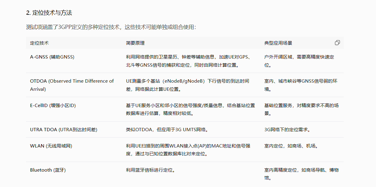
AGNSS === Assisted Global Navigation Satellite System === AGNSS辅助全球导航卫星系统 === 通过接收卫星信号(如GPS)并结合网络提供的辅助数据(如星历、时间校准)进行定位
ECID === Enhanced Cell ID === 增强区位id === 基于服务基站的地理位置(Cell ID)和附加测量参数,如信号强度、终端收发时间差、参考信号接收功率RSRP等,通过单基站或多基站的距离估算进行定位
OTDOA === Observed Time Difference of Arrival === 到达时间差定位法 === 终端测量至少三个基站发送的下行定位信号(如PRS)的到达时间差,通过多边定位法计算位置
https://blog.csdn.net/weixin_40461486/article/details/128133737
╧╧╧╧╧╧╧╧╧╧╧╧╧╧╧╧╧╧╧╧╧╧╧╧╧╧╧╧╧╧╧╧╧╧╧╧╧╧╧╧╧╧╧╧╧╧╧╧╧╧╧╧╧╧╧╧╧╧╧╧╧╧╧╧╧╧╧╧╧╧╧╧╧╧╧╧╧╧╧╧╧╧╧╧╧╧╧╧
_1. 3GPP_RRLP_2G_CP 相关
1.1 RRLP_2G_CP + MSA + SI + AGNSS
1.2 RRLP_2G_CP + MSA + NI + AGNSS
1.3 RRLP_2G_CP + MSB + SI + AGNSS
1.4 RRLP_2G_CP + MSB + NI + AGNSS
1.5 RRLP_2G_CP + MSA + SI + ECID
1.6 RRLP_2G_CP + MSA + NI + ECID
1.7 RRLP_2G_CP + MSB + SI + ECID
1.8 RRLP_2G_CP + MSB + NI + ECID
1.9 RRLP_2G_CP + MSA + SI + OTDOA
1.10 RRLP_2G_CP + MSA + NI + OTDOA
1.11 RRLP_2G_CP + MSB + SI + OTDOA
1.12 RRLP_2G_CP + MSB + NI + OTDOA
1.13 RRLP_2G_CP + MSA + SI + WLAN
1.14 RRLP_2G_CP + MSA + NI + WLAN
1.15 RRLP_2G_CP + MSB + SI + WLAN
1.16 RRLP_2G_CP + MSB + NI + WLAN
_2. 3GPP_RRC_3G_CP 相关
2.1 RRC_3G_CP + MSA + SI + AGNSS
2.2 RRC_3G_CP + MSA + NI + AGNSS
2.3 RRC_3G_CP + MSB + SI + AGNSS
2.4 RRC_3G_CP + MSB + NI + AGNSS
2.5 RRC_3G_CP + MSA + SI + ECID
2.6 RRC_3G_CP + MSA + NI + ECID
2.7 RRC_3G_CP + MSB + SI + ECID
2.8 RRC_3G_CP + MSB + NI + ECID
2.9 RRC_3G_CP + MSA + SI + OTDOA
2.10 RRC_3G_CP + MSA + NI + OTDOA
2.11 RRC_3G_CP + MSB + SI + OTDOA
2.12 RRC_3G_CP + MSB + NI + OTDOA
2.13 RRC_3G_CP + MSA + SI + WLAN
2.14 RRC_3G_CP + MSA + NI + WLAN
2.15 RRC_3G_CP + MSB + SI + WLAN
2.16 RRC_3G_CP + MSB + NI + WLAN
_3. 3GPP_LPP_4G_CP_UP 相关
3.1 LPP_4G_CP + MSA + SI + AGNSS
3.2 LPP_4G_CP + MSA + NI + AGNSS
3.3 LPP_4G_CP + MSB + SI + AGNSS
3.4 LPP_4G_CP + MSB + NI + AGNSS
3.5 LPP_4G_UP + MSA + SI + AGNSS
3.6 LPP_4G_UP + MSA + NI + AGNSS
3.7 LPP_4G_UP + MSB + SI + AGNSS
3.8 LPP_4G_UP + MSB + NI + AGNSS
3.9 LPP_4G_CP + MSA + SI + ECID
3.10 LPP_4G_CP + MSA + NI + ECID
3.11 LPP_4G_CP + MSB + SI + ECID
3.12 LPP_4G_CP + MSB + NI + ECID
3.13 LPP_4G_UP + MSA + SI + ECID
3.14 LPP_4G_UP + MSA + NI + ECID
3.15 LPP_4G_UP + MSB + SI + ECID
3.16 LPP_4G_UP + MSB + NI + ECID
3.17 LPP_4G_CP + MSA + SI + OTDOA
3.18 LPP_4G_CP + MSA + NI + OTDOA
3.19 LPP_4G_CP + MSB + SI + OTDOA 【不支持】
3.20 LPP_4G_CP + MSB + NI + OTDOA 【不支持】
3.21 LPP_4G_UP + MSA + SI + OTDOA
3.22 LPP_4G_UP + MSA + NI + OTDOA
3.23 LPP_4G_UP + MSB + SI + OTDOA 【不支持】
3.24 LPP_4G_UP + MSB + NI + OTDOA 【不支持】
3.25 LPP_4G_CP + MSA + SI + WLAN
3.26 LPP_4G_CP + MSA + NI + WLAN
3.27 LPP_4G_CP + MSB + SI + WLAN
3.28 LPP_4G_CP + MSB + NI + WLAN
3.29 LPP_4G_UP + MSA + SI + WLAN
3.30 LPP_4G_UP + MSA + NI + WLAN
3.31 LPP_4G_UP + MSB + SI + WLAN
3.32 LPP_4G_UP + MSB + NI + WLAN
_4. OMA_LPPe_4G_CP_UP 相关
4.1 LPPe_4G_CP + MSA + SI + AGNSS
4.2 LPPe_4G_CP + MSA + NI + AGNSS
4.3 LPPe_4G_CP + MSB + SI + AGNSS
4.4 LPPe_4G_CP + MSB + NI + AGNSS
4.5 LPPe_4G_UP + MSA + SI + AGNSS
4.6 LPPe_4G_UP + MSA + NI + AGNSS
4.7 LPPe_4G_UP + MSB + SI + AGNSS
4.8 LPPe_4G_UP + MSB + NI + AGNSS
4.9 LPPe_4G_CP + MSA + SI + ECID
4.10 LPPe_4G_CP + MSA + NI + ECID
4.11 LPPe_4G_CP + MSB + SI + ECID
4.12 LPPe_4G_CP + MSB + NI + ECID
4.13 LPPe_4G_UP + MSA + SI + ECID
4.14 LPPe_4G_UP + MSA + NI + ECID
4.15 LPPe_4G_UP + MSB + SI + ECID
4.16 LPPe_4G_UP + MSB + NI + ECID
4.17 LPPe_4G_CP + MSA + SI + OTDOA
4.18 LPPe_4G_CP + MSA + NI + OTDOA
4.19 LPPe_4G_CP + MSB + SI + OTDOA
4.20 LPPe_4G_CP + MSB + NI + OTDOA
4.21 LPPe_4G_UP + MSA + SI + OTDOA
4.22 LPPe_4G_UP + MSA + NI + OTDOA
4.23 LPPe_4G_UP + MSB + SI + OTDOA
4.24 LPPe_4G_UP + MSB + NI + OTDOA
4.25 LPPe_4G_CP + MSA + SI + WLAN
4.26 LPPe_4G_CP + MSA + NI + WLAN
4.27 LPPe_4G_CP + MSB + SI + WLAN
4.28 LPPe_4G_CP + MSB + NI + WLAN
4.29 LPPe_4G_UP + MSA + SI + WLAN
4.30 LPPe_4G_UP + MSA + NI + WLAN
4.31 LPPe_4G_UP + MSB + SI + WLAN
4.32 LPPe_4G_UP + MSB + NI + WLAN
_5. SUPL2.0_UP 相关
5.1 SUPL2.0_UP + MSA + SI + AGNSS
5.2 SUPL2.0_UP + MSA + NI + AGNSS
5.3 SUPL2.0_UP + MSB + SI + AGNSS
5.4 SUPL2.0_UP + MSB + NI + AGNSS
5.5 SUPL2.0_UP + MSA + SI + ECID
5.6 SUPL2.0_UP + MSA + NI + ECID
5.7 SUPL2.0_UP + MSB + SI + ECID
5.8 SUPL2.0_UP + MSB + NI + ECID
5.9 SUPL2.0_UP + MSA + SI + OTDOA
5.10 SUPL2.0_UP + MSA + NI + OTDOA
5.11 SUPL2.0_UP + MSB + SI + OTDOA
5.12 SUPL2.0_UP + MSB + NI + OTDOA
5.13 SUPL2.0_UP + MSA + SI + WLAN
5.14 SUPL2.0_UP + MSA + NI + WLAN
5.15 SUPL2.0_UP + MSB + SI + WLAN
5.16 SUPL2.0_UP + MSB + NI + WLAN
_6. SUPL3.0_UP 相关
6.1 SUPL3.0_UP + MSA + SI + AGNSS
6.2 SUPL3.0_UP + MSA + NI + AGNSS
6.3 SUPL3.0_UP + MSB + SI + AGNSS
6.4 SUPL3.0_UP + MSB + NI + AGNSS
6.5 SUPL3.0_UP + MSA + SI + ECID
6.6 SUPL3.0_UP + MSA + NI + ECID
6.7 SUPL3.0_UP + MSB + SI + ECID
6.8 SUPL3.0_UP + MSB + NI + ECID
6.9 SUPL3.0_UP + MSA + SI + OTDOA
6.10 SUPL3.0_UP + MSA + NI + OTDOA
6.11 SUPL3.0_UP + MSB + SI + OTDOA
6.12 SUPL3.0_UP + MSB + NI + OTDOA
6.13 SUPL3.0_UP + MSA + SI + WLAN
6.14 SUPL3.0_UP + MSA + NI + WLAN
6.15 SUPL3.0_UP + MSB + SI + WLAN
6.16 SUPL3.0_UP + MSB + NI + WLAN
AGPS和SUPL关系
AGPS和SUPL的关系可以总结为: 【 SUPL [implement实现]是OMA制定的用于实现AGPS [interface] 用户平面[UserPlane(scenerio)] 通信的协议标准 】


承载框架:Control plane(CP)、User plane(UP)
CP走的是专用信令通道——利用 3GPP_2G , RRLP_3G ,  LPP_4G  协议,稳定性高,成本高
UP走的是TCP/IP数据通道——利用SUPL协议,稳定性低,成本低


AGPS === Assisted Global Positioning System === 辅助全球卫星定位系统

SUPL === Secure User Plane Location === 安全用户面定位  === UP用户面协议   === 应用层协议

3GPP === 3rd Generation Partnership Project  ===  第三代合作伙伴计划
(3GPP 由全球多个电信标准化组织组成的国际合作机构,旨在制定和维护移动通信领域的技术标准与规范,涵盖从3G到5G及未来的演进技术)


RRLP === Radio Resource LCS Protocol === 无线电定位服务协议 === CP控制面协议  === 网络层协议
RRLP 是 GSM(2G) 网络  CP 控制面协议  中用于定位服务的控制平面协议


RRC === Radio Resource Control === 无线电资源控制  === CP控制面协议   === 网络层/数据链路层
RRC 是 UMTS(3G)WCDMA网络  CP    的控制平面协议
RRC和RRLP是不同移动网络世代(UMTS_3G_CP_RRC vs GSM_2G_CP_RRLP )中用于传输AGPS辅助数据的控制平面协议,由3GPP制定,属于不同编码标准但功能相似.


LPP  === LTE Position Protocol  === LTE通信定位协议 ===  CP控制面协议 || UP用户面协议  === 应用层协议
LPPe === LPP Extensions === OMA LPP扩展协议
LPP  是 LTE(4G)网络  CP 的控制平面协议 同时 也可以工作在 UP空户面中的协议 ,  LPP既可以用于控制平面,也可以用于用户平面, 具体取决于传输方式和应用场景
在控制平面场景中,LPP通过信令协议(如RRC)传输
在用户平面场景中,LPP可通过安全用户面协议(如SUPL)传输


LPP和LPPe的主要区别:

1.标准设计组织差异
LPP  LPP是3GPP制定的LTE定位协议,用于用户设备与基站通信;
LPPe是OMA制定的扩展协议,基于LPP增加功能,支持更高精度定位,如连续测量和UE自主计算位置。同时,LPPe可以在用户平面和控制平面中使用,扩展了LPP的应用场景。

2. OTDOA定位位模式支持的差异
LPP仅支持  OTDOA UE-assisted模式
LPPe支持   OTDOA UE-assisted模式  || UE-based模式 两种模式


3.支持连续测量feature的差异
LPP仅支持  周期性测量  (周期性测量可能导致设备在测量间隔中关闭GNSS模块)
LPPe支持  连续测量 允许连续载波相位测量 ( 不关闭GNSS模块  )

4,独立性差异
LPP为   独立协议
LPPe并非独立协议,而是与LPP组合使用


═════════════════════════════════════════════
MTK_AGPS_Profiles_XML_配置项
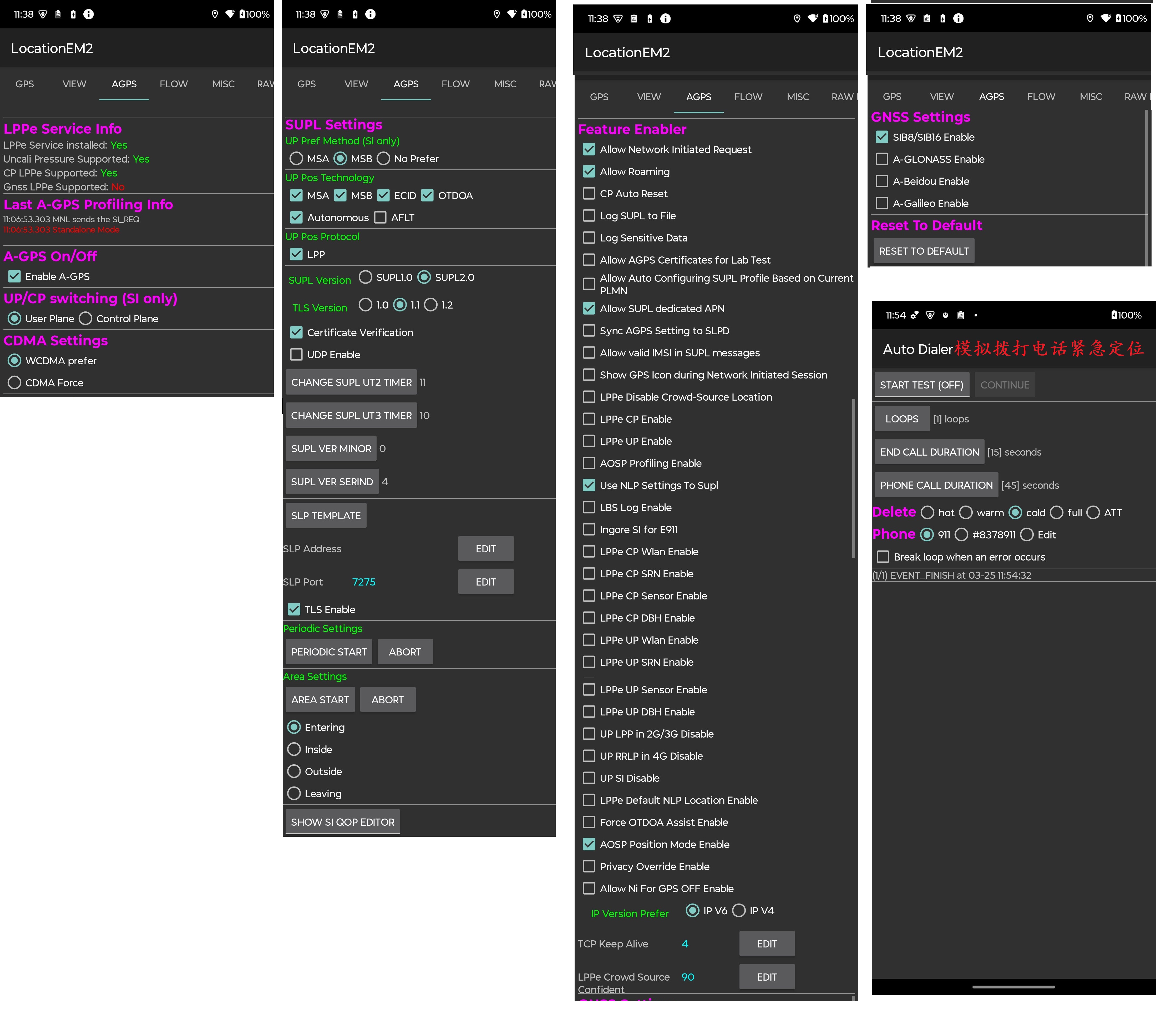
gnss_setting(XML_TAG)
a_gps_satellite_enable
 (circle_5 暖启动GPS  只有第一次会触发SUPL 第二次开始不会触发SUPL 使用热启动 定位时间明显缩短)

<gnss_setting
a_gps_satellite_enable = "true"    ###使用从agps 得到的 gps卫星数据用于定位
/>
 (circle_5 暖启动GPS  五次都会触发SUPL 每次会触发SUPL  由于配置为false 不使用agps的卫星数据 导致SUPL完成后又要搜星 定位时间明显加长)

<gnss_setting
a_gps_satellite_enable = "false"    ###使用从agps 得到的 gps卫星数据用于定位
/>
SUPL_(安全用户面定位)_总体介绍
SUPL === Secure User Plane Location === 安全用户面定位
https://blog.csdn.net/dailinqing1984/article/details/45842199

基于移动终端位置的定位服务正日益普及。SUPL(安全用户面定位)采用用户平面的数据承载来传输定位辅助信息(如GPS辅助数据),并在移动终端和网络之间携带定位技术相关的协议。SUPL的目的是代替或补充移动网络中的现有定位标准-基于控制平面信令定位。


SUPL假设移动网络或其他的接入网络能够在终端和定位服务器之间建立数据承载。

SUPL利用现有可用和可能的标准。随着需求的增加,SUPL应该可扩展以支持更多的定位技术,以保证不同的定位技术采用相关的机制。在初期,SUPL将全面利用A-GPS的功能,并对现有网络做最小的改动。从SUPL R2开始,引入了A-GNSS的概念,以支持所有可以采用的卫星导航系统辅助定位技术,例如GPS,GALILEO(伽利略定位系统)等。


SUPL需求文档描述了高层的功能需求,包括SUPL的安全、互通和私密等具体内容。

SUPLE不是一个应用接口协议,它并不向LBS应用提供API接口。外部LBS应用和定位平台的接口仍然遵循OMA MLP或3GPP Le接口协议。

SUPL(Secure User Plane Location)是 OMA(Open Mobile Alliance) LOC(Location)工作组指定的基于用户层面的 AGPS 定位技术标准。

SUPL 协议是 AGPS 终端和 AGPS 定位平台之间 Lup 接口的协议,用户传输 GNSS 辅助数据和
位置信息。
SUPL 包含位置用户层(Lup:Location User Plane)接口、安全功能(认证和授权)、收费功
能、漫游功能、保密功能等。
SUPL 标准目前有两个版本 SUPL1.0 和 SUPL2.0.
SUPL1.0 版本主要是对立即定位服务进行了定义;
SUPL2.0 增加了周期性触发定位和基于位置时间的触发定位等功能
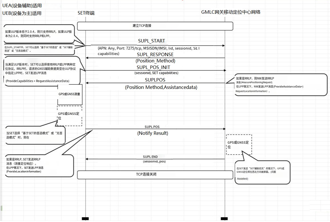
SUPL协议帧类型
SUPL === Secure User Plane Location === 安全用户面定位协议帧类型
SUPL帧交互图
Common_AGPS_SUPL分析
AGPS Failed reason 集合
Received Error                                     【Pos_NoMeasurement:】

a_gnss_ProvideLocationInformation Location Error-  【thereWereNotEnoughSatellitesReceived】

commonIEsProvideLocationInformation-               【positionMethodFailure】
nfwlocationattribution 无权限
nfwlocationattribution 是一个特殊的应用,该应用作为运营商发起NI请求时候本地的代理对应,运营商发起NI AGPS 请求时
需要使用到本地的位置访问权限即 ACCESS_FINE_LOCATION   ACCESS_COARSE_LOCATION ACCESS_BACKGROUND_LOCATION  ,
授予该应用 nfwlocationattribution Location权限之后 网络端的NI请求才能正常被响应

nfw === noframework


  Package [com.mxtxrxla.nfwlocationattribution] (20a0dfe): bugreport搜关键字【.nfwlocationattribution] (】
      runtime permissions:
        android.permission.ACCESS_FINE_LOCATION: granted=false,【这里必须授权为true】 flags=[ USER_SENSITIVE_WHEN_GRANTED]
        android.permission.ACCESS_COARSE_LOCATION: granted=false, flags=[ REVOKE_WHEN_REQUESTED|USER_SENSITIVE_WHEN_GRANTED]
        android.permission.ACCESS_BACKGROUND_LOCATION: granted=false, flags=[ USER_SENSITIVE_WHEN_GRANTED|RESTRICTION_UPGRADE_EXEMPT]


Could you double check follow "Carrier Location Access" had change location permission?
If not, pls set DUT sa bellow and retest TC again.

【Carrier Location Access】 change location permission to "Allow all the time".
1.* Settings - Apps - See all apps - Show system apps
2.* Find "Carrier Location Access" app and change location permission to "Allow all the time"
3. "Google Location Accuracy" must be OFF
   • Settings - Location - Location services
   • Find "Google Location Accuracy" and change to OFF
MTK_AGPS_SUPL分析
MTK_AGPS测试APK_LocationEM2
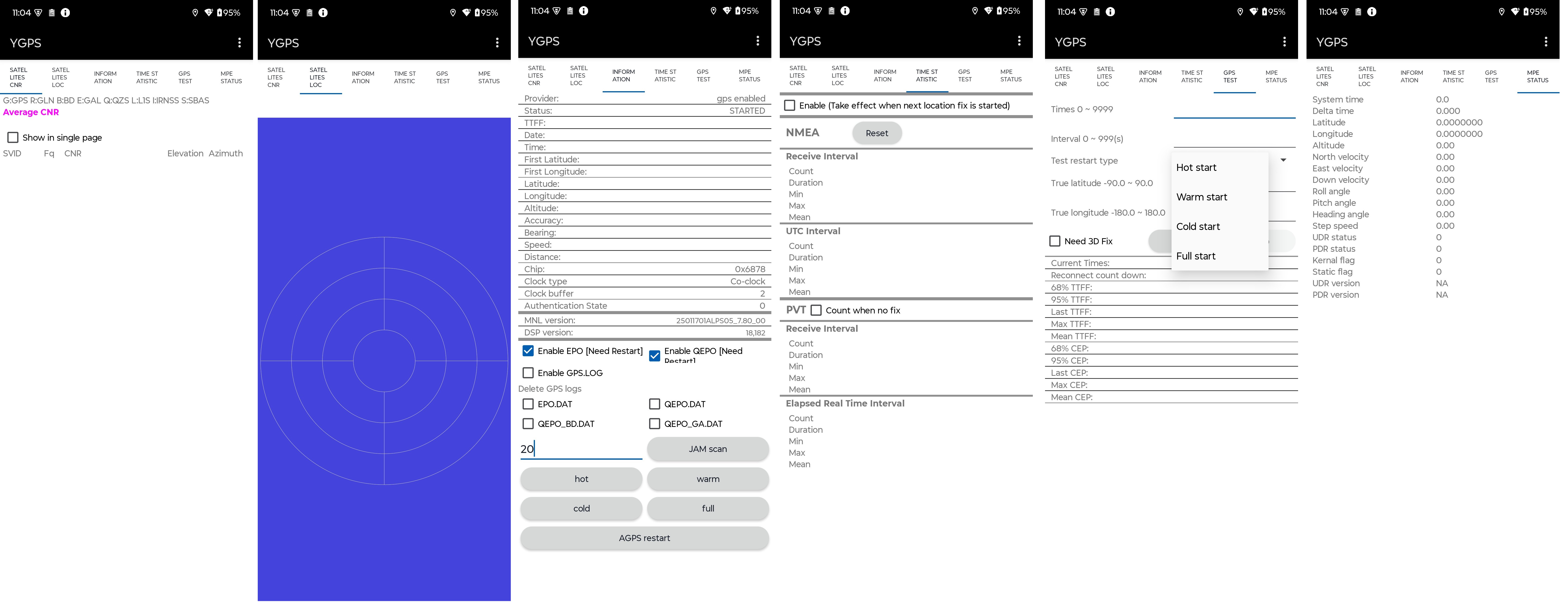
MTK_GPS模块测试APK_YGPS
MTK_LPP_LocationInformationType字段解析
LocationInformationType ::= ENUMERATED {
 locationEstimateRequired(0),
 locationMeasurementsRequired(1),
 locationEstimatePreferred(2),
 locationMeasurementsPreferred(3),
 ...
}
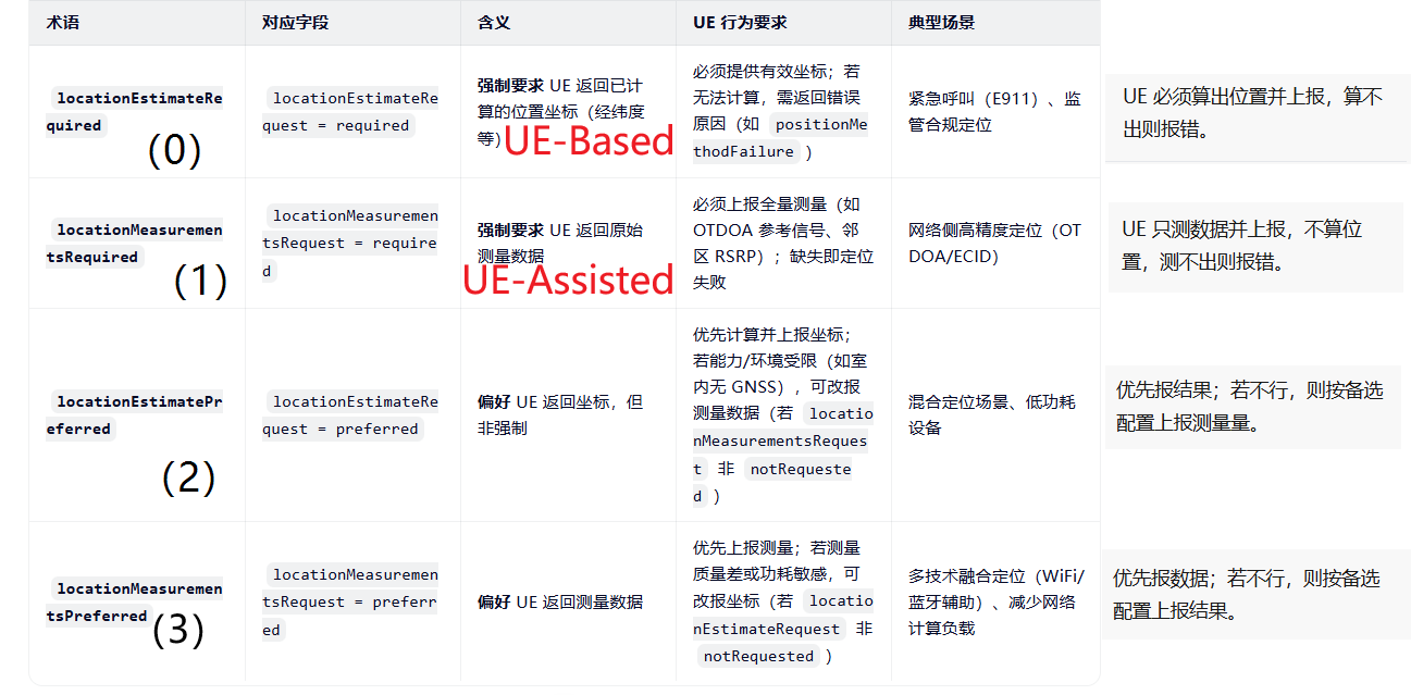
| 术语 | 对应字段 | 含义 | UE 行为要求 | 典型场景 |
|---|---|---|---|---|
locationEstimateRequired(0) |
locationEstimateRequest = required |
【 UE-Based】 强制要求 UE 返回已计算的位置坐标(经纬度等) | 必须提供有效坐标;若无法计算,需返回错误原因(如 positionMethodFailure) |
紧急呼叫(E911)、监管合规定位 |
locationMeasurementsRequired(1) |
locationMeasurementsRequest = required |
【UE-Assisted】 强制要求 UE 返回原始测量数据 | 必须上报全量测量(如 OTDOA 参考信号、邻区 RSRP);缺失即定位失败 | 网络侧高精度定位(OTDOA/ECID) |
locationEstimatePreferred(2) |
locationEstimateRequest = preferred |
偏好 UE 返回坐标,但非强制 【混合/切换_优先位置】 | 优先计算并上报坐标;若能力/环境受限(如室内无 GNSS),可改报测量数据(若 locationMeasurementsRequest 非 notRequested) |
混合定位场景、低功耗设备 |
locationMeasurementsPreferred(3) |
locationMeasurementsRequest = preferred |
偏好 UE 返回测量数据 【混合/切换_优先测量数据】 | 优先上报测量;若测量质量差或功耗敏感,可改报坐标(若 locationEstimateRequest 非 notRequested) |
多技术融合定位(WiFi/蓝牙辅助)、减少网络计算负载 |
MTK_LPP_LocationInfo_3Dposition_经纬度数值角度转换
Main_Log:
03-14 10:44:11.133  1944  1992 D GnssLocationProvider: reportLocation Location[gps 47.616522,-122.204722 hAcc=17.7 et=+1h8m52s719ms alt=56.8 vAcc=43.8 vel=0.23368388 sAcc=1.2 bear=1.79 bAcc=179.9]

Modem_Log: LPP MS->NW  PROVIDE_LOCATION_INFOMATION  帧
messageExtensionBody: provideLocationInformation (5)
    provideLocationInformation
        commonIEsProvideLocationInformation
            highAccuracy3Dposition
            latitude: 1136174463         【32bit存储精度 (-90)-(+90)   纬度】
            longitude: -1457959119       【32bit存储精度 (-180)-(+180) 经度】
            uncertainty-semimajor: 173
            uncertainty-semiminor: 173
            offset-angle: 90
            confidenceHorizontal: 90
            altitude: 8227
            uncertainty-altitude: 206
            confidenceVertical: 90
            .... ..1. extUncertRange: True


纬度数 = (纬度数值*90) /2147483648
纬度数 = (纬度数值*90) /2^31
                        2^31=2147483648
zcalcul_H2.bat  (纬度数值*90)/2147483648
zcalcul_H2.bat  (1136174463*90)/2147483648
                (1136174463*90)/2147483648   ═════════   47.616522


lon经度数 = (lon经度数值*180) /2^31
lon经度数 = (lon经度数值*180) /2147483648
                               2^31=2147483648
zcalcul_H2.bat  (lon经度数值*180)/2147483648
zcalcul_H2.bat  (-1457959119*180)/2147483648
                (-1457959119*180)/2147483648   ═════════   -122.204722


【[gps 47.616522,-122.204722]】
【latitude: 1136174463  longitude: -1457959119】 highAccuracy3Dposition  经纬度转换关系

转换关系:
zcalcul_H2.bat  (latitude[纬度数值]*90)/2147483648
                        (1136174463*90)/2147483648     ═════════   47.616522

zcalcul_H2.bat  (longitude[经度数值]*180)/2147483648
                        (-1457959119*180)/2147483648   ═════════   -122.204722
MTK_ELT 帧解析
ERRC 帧解析
 ERRC 帧解析


_______________ 【ERRC】__________________________________
【Direcrion】  |【Layer】  |【Message_Type】
[NW->MS]       | ERRC      | RRCConnectionReconfiguration
[NW->MS]       | ERRC      | DLInformationTransfer
               |           |
               |           |
[MS->NW]       | ERRC      | RRCConnectionReconfigurationComplete
[MS->NW]       | ERRC      | ULInformationTransfer
[MS->NW]       | ERRC      | MeasurementReport


ERRC: E-UTRA RRC (Evolved Universal Terrestrial Radio Access Radio Resource Control) 是4G LTE网络中的无线资源控制协议

RRCConnectionReconfiguration:  是网络NW发送给UE的配置命令,用于修改现有的RRC连接 用于传递测量配置、移动性控制、无线资源配置等 目的在动态调整RRC连接的参数

RRCConnectionReconfigurationComplete: UE在成功应用配置后发送该给到NW ,标志重配置完成 .

DLInformationTransfer: 是在RRC连接状态下,从网络NW端 传输NAS(Non-Access Stratum 非接入层 ,NAS负责控制平面信令的传输 负责处理UE和核心网之间的 CP 信令 ) 信息、时间同步信息等到 UE 设备端

ULInformationTransfer: RRC ULInformationTransfer主要用于在RRC连接状态下传输NAS专用信息或MR-DC相关的控制信息,如测量报告、失败信息、UE辅助信息等

MeasurementReport: 用户设备(UE)向NW 发送的关键测量报告,如服务小区和邻区的信号质量(RSRP、RSRQ等),以便网络决定是否发起切换,比如从5G切换到4G的情况
ESM 帧解析
_______________ 【ESM】__________________________________
【Direcrion】  |【Layer】  |【Message_Type】
[NW->MS]       | ESM       | MSG_ACTIVATE_DEFAULT_EPS_BEARER_CONTEXT_REQUEST
[NW->MS]       | ESM       | MSG_DEACTIVATE_EPS_BEARER_CONTEXT_REQUEST
[NW->MS]       | ESM       | MSG_ACTIVATE_DEDICATED_EPS_BEARER_CONTEXT_REQUEST
               |           |
               |           |
[MS->NW]       | ESM       | MSG_DEACTIVATE_EPS_BEARER_CONTEXT_ACCEPT
[MS->NW]       | ESM       | MSG_PDN_DISCONNECT_REQUEST
[MS->NW]       | ESM       | MSG_PDN_CONNECTIVITY_REQUEST
[MS->NW]       | ESM       | MSG_ACTIVATE_DEFAULT_EPS_BEARER_CONTEXT_ACCEPT
[MS->NW]       | ESM       | MSG_ACTIVATE_DEDICATED_EPS_BEARER_CONTEXT_ACCEPT
               |           |
               |           |


EPS: (Evolved Packet System,演进分组系统)  EPS由 演进分组核心网(EPC) 和 演进通用陆地无线接入网 (E-UTRAN) 构成

ESM: ( EPS  Session Management EPS会话管理) 处理 EPS承载上下文(EPS Bearer Context) 的生命周期管理,包括激活、修改、去激活以及资源请求响应,是LTE/5G网络中负责管理用户会话和承载的核心控制平面功能

PDN: (Packet Data Network分组数据网络)  在移动通信中,PDN连接是用户设备(UE)连接到外部数据网络的通道 , PDN是数据传输通道

NAS: (Non-Access Stratum 非接入层 ,NAS负责控制平面信令的传输 负责处理UE和核心网之间的 CP 信令 )  负责UE与核心网之间的信令CP交互

MSG_DEACTIVATE_EPS_BEARER_CONTEXT_REQUEST: 网络侧NW 发起的给到UE的 用于停用UE的某个EPS承载上下文或断开PDN连接时,会向UE发送该 消息

MSG_DEACTIVATE_EPS_BEARER_CONTEXT_ACCEPT:  UE接受到MSG_DEACTIVATE_EPS_BEARER_CONTEXT_REQUEST消息后  完成承载上下文删除后 需回复NW 已供NW确认DUT断开PDN 禁用上下文操作完成

MSG_PDN_DISCONNECT_REQUEST: 是用户设备(UE)发起的PDN连接断开请求, 该请求需包含与目标PDN关联的默认承载的链接EPS承载标识(Linked EPS Bearer Identity)

MSG_PDN_CONNECTIVITY_REQUEST: 由移动终端(MS)UE 发送给网络(NW)的消息,用于请求PDN连接,并且包含 携带APN、PDN类型、PCO等参数,RequestType请求类型(如 "Emergency紧急服,Handover切换) 用于建立数据会话 该消息在不同场景下(如紧急情况)有不同的处理流程,确保服务的正确建立


MSG_ACTIVATE_DEFAULT_EPS_BEARER_CONTEXT_REQUEST: (激活默认EPS承载上下文请求)是移动性管理实体(MME)NW在UE附着(Attach)或建立PDN连接时发起的核心流程,用于为终端(UE)建立默认的IP连接

MSG_ACTIVATE_DEFAULT_EPS_BEARER_CONTEXT_ACCEPT: UE在成功激活默认承载后向网络发送的确认消息,通常作为附着完成的一部分,(UE)对网络侧下发的默认承载激活请求的确认响应

MSG_ACTIVATE_DEDICATED_EPS_BEARER_CONTEXT_REQUEST: 是由网络侧(NW)发起的,用于为特定的服务(如VoLTE,实时语音,视频流)建立专用EPS承载 专属 QoS 保障的承载通道

MSG_ACTIVATE_DEDICATED_EPS_BEARER_CONTEXT_ACCEPT: (激活专用EPS承载上下文接受消息)是用户设备(UE)对网络侧发起的专用EPS承载激活请求的确认响应


Attach Procedure:附着流程, LTE网络中的附着流程(Attach Procedure)是用户设备(UE)注册到核心网并建立通信通道的关键过程
1.UE发送Attach Request消息,携带身份标识(IMSI或GUTI)、能力信息、APN等。
2.eNodeB转发给MME。
3.MME进行鉴权和安全流程,可能涉及HSS获取鉴权向量。
4.位置更新到HSS。
5.建立默认EPS承载,包括选择SGW和PGW,分配IP地址。
6.MME发送Attach Accept,UE确认,完成RRC配置,建立无线承载。
7.最终UE状态更新为已注册,可以通信。
EMM 帧解析
_______________ 【EMM】__________________________________
【Direcrion】  |【Layer】  |【Message_Type】
[NW->MS]       | EMM       | Downlink_Generic_NAS_Transport
               |           |
               |           |
[MS->NW]       | EMM       | Uplink_Generic_NAS_Transport
               |           |


Downlink_Generic_NAS_Transport: (下行通用NAS传输) 是LTE和5G网络中用于传输封装应用层消息的关键机制,消息不限于传统控制信令(如移动性管理),而是支持多种应用场景的封装数据

Uplink_Generic_NAS_Transport: 特定的非接入层(NAS)上行传输机制,用于用户设备(UE)向核心网络发送封装化的应用层协议数据。机制允许UE通过NAS消息携带来自不同应用程序的协议数据(例如位置服务LPP消息),
LPP 帧解析
_______________ 【LPP】__________________________________
【Direcrion】  |【Layer】  |【Message_Type】
[NW->MS]       | LPP       | REQUEST_CAPABILITIES
[NW->MS]       | LPP       | ACKNOWLEDGE
[NW->MS]       | LPP       | REQUEST_LOCATION_INFORMATION
[NW->MS]       | LPP       | PROVIDE_ASSISTANCE_DATA
               |           |
[MS->NW]       | LPP       | PROVIDE_CAPABILITIES
[MS->NW]       | LPP       | PROVIDE_LOCATION_INFORMATION
[MS->NW]       |LPP        | REQUEST_ASSISTANCE_DATA
               |           |
               |           |
               |           |
               |           |
               |           |
               |           |
               |           |


REQUEST_CAPABILITIES:
ACKNOWLEDGE:
REQUEST_LOCATION_INFORMATION:
PROVIDE_ASSISTANCE_DATA:
PROVIDE_CAPABILITIES:
PROVIDE_LOCATION_INFORMATION:
REQUEST_ASSISTANCE_DATA:


Data字段:


transactionID : LPP-TransactionID序列的组成部分,该序列包含两个关键字段: 【1.Initiator(枚举 [locationServer ||targetDevice]) 】【2.TransactionNumber(int整数类型) 0到255取值】
                【TransactionNumber:Initiator 】共同组成事务标识符(LPP-TransactionID),用于区分不同的定位事务
                 当位置服务器(locationServer)发起一个定位请求时,会生成唯一的TransactionNumber来标识该次交互


TransactionNumber: (int整数类型) 0到255取值  唯一的TransactionNumber来标识该次交互 一次交互

// 在LPP协议中,当发起一个事务时,Initiator标识了事务的发起方是位置服务器(locationServer)还是目标设备(targetDevice)
// 比如,当位置服务器向目标设备请求能力信息时,Initiator就是locationServer;反之,如果目标设备主动发起请求,则Initiator是targetDevice。这有助于双方在处理事务时明确角色和流程
// 如果该值错误  将可能造成错误
Initiator:  【 Initiator: locationServer 和 Initiator: targetDevice 】


 【TransactionNumber:Initiator 】 在一次事物id下应该是一致的,否则可能出现流程错误的问题


sequenceNumber: 11当前帧的序列表    在ACK帧中 会存在ackIndicator: 11 来表示对序列11帧的确认收到  【搜索关键字  sequenceNumber:|ackIndicator:】
Qcom_AGPS_SUPL分析
Qcom_QCAT_分析Logid
| LogID | 名称 | 用途 |
|---|---|---|
| 0x1475 | GPS_EVENT | GPS引擎事件 |
| 0x1476 | GPS_ME_POSITION_REPORT | 定位结果上报 |
| 0x1478 | GPS_ME_SV_STATUS | 卫星状态报告 |
| 0x147A | GPS_ME_SV_MEASUREMENT | 卫星测量值 |
| 0x147F | GPS_ME_AIDING_DATA_REQ | 辅助数据请求 |
| 0x14B7 | GPS_LPP_MSG | LPP协议消息 |
| 0x147C | GPS_ME_EPHEMERIS | 星历数据 |
Log ID	名称	                    用途
0x1475	GPS_EVENT	               GPS引擎事件
0x1476	GPS_ME_POSITION_REPORT	  定位结果上报
0x1478	GPS_ME_SV_STATUS	      卫星状态报告
0x147A	GPS_ME_SV_MEASUREMENT	  卫星测量值
0x147F	GPS_ME_AIDING_DATA_REQ	  辅助数据请求
0x14B7	GPS_LPP_MSG	              LPP协议消息
0x147C	GPS_ME_EPHEMERIS	      星历数据

SUPL_Qcom_degreesLatitud_degreesLongitude与实际经纬度转换
https://www.sharetechnote.com/html/LBS.html
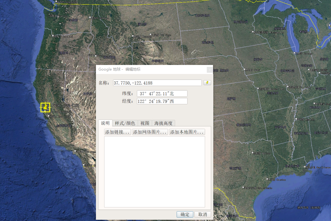
locationEstimate ellipsoidPointWithAltitudeAndUncertaintyEllipsoid :
{
latitudeSign north, 【+北纬 -南纬】
degreesLatitude 3520888, 【纬度_23bit】 23个bit值标识 范围 (0°--90°) 实际纬度转换公式: 【zcalcul_H2.bat degreesLatitude/(8388607/90)]】 2^23=8388607
degreesLongitude -5705130, 【经度_24bit】 24个bit值标识 范围 (-180°-+180°) 实际经度转换公式: 【zcalcul_H2.bat degreesLongitude/(16777216/360)]】 2^24=16777216
}
degreesLatitude 23个bit值标识 的数值需映射到实际纬度范围(0° 至 +90°) 北纬 南纬 由 latitudeSign决定( north +北纬) (south -北纬)
实际纬度转换公式:
【zcalcul_H2.bat degreesLatitude/(8388607/90) 】 2^23=8388607
【纬度_23bit】 转换 degreesLatitude 3520888: 2^23=8388607
zcalcul_H2.bat degreesLatitude/(8388607/90)
zcalcul_H2.bat 3520888/(8388607/90)
zcalcul_H2.bat 3520888/(8388607/90) ═════════ 37.775034639243444 ( 北纬: 37.775034639243444 )
degreesLongitude 24个bit值标识 范围 (-180°-+180°) 东经为正数 西经为负数
实际经度转换公式:
【zcalcul_H2.bat degreesLongitude/(16777216/360)]】 2^24=16777216
【经度_24bit】 转换 degreesLongitude -5705130: 2^24=16777216
zcalcul_H2.bat degreesLongitude/(16777216/360)
zcalcul_H2.bat -5705130/(16777216/360)
zcalcul_H2.bat -5705130/(16777216/360) ═════════ -122.41880893707275 ( 西经: -122.4188 )
════════════════════════════════════
latitudeSign north,
degreesLatitude 3520888,
degreesLongitude -5705130
最终转换为如下地址
37.7750 北,-122.4188 西
════════════════════════════════════
GPS周概念_Qcom_NV6264
GPS周(GPS Week)是GPS系统内部采用的时间单位,其时间零点定义为1980年1月6日0时0分0秒(UTC)。
最大时间单位是周,一周包含604,800秒(即7天)。
GPS周数从1980年1月6日开始计数,每过一周增加1


GPS周 1024(翻牌数)  在线计算器
https://www.labsat.co.uk/index.php/cn/customer-profiles/252-calculators-cn


QC在2013年将硬编码的最小GPS周数 NV6264 从1054改为1738,以避免周数翻转问题,
支持长期使用的设备。测试时可能需要临时调整这个值


6264,CGPS Minimum GPS Week Number,cgps_minimum_gps_week_number,GPS  【最小_周翻转数值】


默认1024(翻牌数)____ 19.6年翻牌一次
GPS 起始日: 1980.1.6     1024(翻牌数)    周数:  0周
第一翻牌日: 1999.8.22    1024(翻牌数)    周数:  1024周
第二翻牌日: 2019.4.7     1024(翻牌数)    周数:  2048周
特殊时间点: 2032.12.12   1024(翻牌数)    周数:  2762周
第三次翻拍: 2038.11.21   1024(翻牌数)    周数:  3072周


(将GPS接收机的寿命延长到默认(1024)翻拍时间点 2019.4.7之后 更改当前翻拍常量从 1024 改为(1738),使得翻牌日变更为2032.12.12日)
1738(翻牌数)______ 33.4年翻牌一次
GPS 起始日: 1980.1.6     1024(翻牌数)    周数:  0周
第一翻牌日: 1999.8.22    1738(翻牌数)    周数:  1024周
第二翻牌日: 2032.12.12   1738(翻牌数)    周数:  2762周=【1024周+1738周】 (1024+1738=2762)


在模拟过去GPS周信号的模拟器环境中进行测试时,可能会出现问题。
例如,目前,所有Spirent场景都是旧的。
因此,通过上述改进,最少1738周可能会导致PLTS和ULTS测试出现问题。
在这种情况下,有必要使用NV项6264 (NV_CGPS_MINIMUM_GPS_WEEK_NUMBER_I)设置为 1738 覆盖最小GPS周。
测试完成后,将NV项还原为当前GPS周数值。

NV#6264 (NV_CGPS_MINIMUM_GPS_WEEK_NUMBER_I) setting for running test with GPS simulator or PLTS/ULTS
From 2013, QC started to include following CR change for setting the hard coded minimum GPS week number from 1054 to 1738.

PLTS  === Position Location Test System === 定位测试系统
ULTS  === UMTS(3G) Location Test System === 3G移动网络定位测试系统


 it`s due to NV item 6264 not set to 1738 under Simulator test. 在模拟测试环境下 需要把 NV#6264 设置为  1738


Qcom_Log 中搜索的 GPS Week 关键字


0x1478  GNSS Clock Report
GPS Week = 2123       --> 时间点为:   2020.9.13

w_MinGpsWeekNumber = 2307   【错误】
w_MinGpsWeekNumber = 1738   【正确】   NV#6264 to 1738.   【6264,CGPS Minimum GPS Week Number,cgps_minimum_gps_week_number,GPS】


Tip: 在北斗独立定位试验测试环境下出现过问题,在 NV70326 选中了0X1906  选中了  【Controls BeiDou  outside of the United States】
     需要把  NV6264 w_MinGpsWeekNumber 进行修改 从2376 改为 1738 以使得在实验室环境下北斗独立定位能成功
Qcom_Modem_帧类型分类
帧格式:
Level_1 : Level_2 :  identify

Log Packets :  GNSS  : 0x1386  CGPS Report Server Tx         【 UE发送_NW网络接受  Continue GPS  连续全球定位系统报告】
Log Packets :  GNSS  : 0x1387  CGPS Report Server Rx         【 UE接受_NW网络发送  Continue GPS  连续全球定位系统报告】

Log Packets :  GNSS  : 0x1476  GNSS Position Report          【 GNSS位置报告  包含 Latitude纬度 Longitud经度  】
Log Packets :  GNSS  : 0x1477  GNSS GPS Measurement Report   【 Report_GPS 测定报告 】

Log Packets :  GNSS  : 0x1478  GNSS Clock Report             【GPS时钟(时间信息) 包括 GPSweek  w_MinGpsWeekNumber 】


Log Packets :  GNSS  : 0x1886  GNSS GAL Measurement Report   【 Report_Galileo 欧洲伽利略定位系统 信号 测量报告 】
Qcom_Log_解析步骤
1.首先 QXDM 打开Log , 右键点击 Refliter Items 后在弹出框 左侧选中 【v】Log Package , 右侧选中 [0x1386 [0x1387 [0x1476 [0x1477 [0x1544 后点击OK
[0x1386 CGPS Report Server Rx DUT安卓设备接收
[0x1387 CGPS Report Server Tx DUT安卓设备发送
[0x1476 GNSS Position Report GPS位置报告
[0x1477 GNSS GPS Measurement Report GNSS卫星信号报告
[0x1544 QMI_MCS_QCSI_PKT qmiLocEventInjectWifiApDataReq Modem请求WIFI数据
2. 在新打开的 Item Refliter View 中(此时空白) 点击 Refresh Views,此时开始执行 过来指定 item type 的操作
3.在 完成 Refresh Views 操作后 右键全选 Copy All Item to File 保存文件 为新的 1209_1_XXX.hdf Log 文件
4. 在QXDM 重新打开上个步骤的 XXX.hdf
此时即可 右键 或 打开 ctrl+F ,打开搜索框 进行 文本的 正则表达式搜索
════════════════════════════════
thereWereNotEnoughSatellitesReceived|0x1386|0x1387
════════════════════════════════
Ctrl+N 下一个搜索到的文本
Ctrl+Shift+N 上一个搜索到的文本
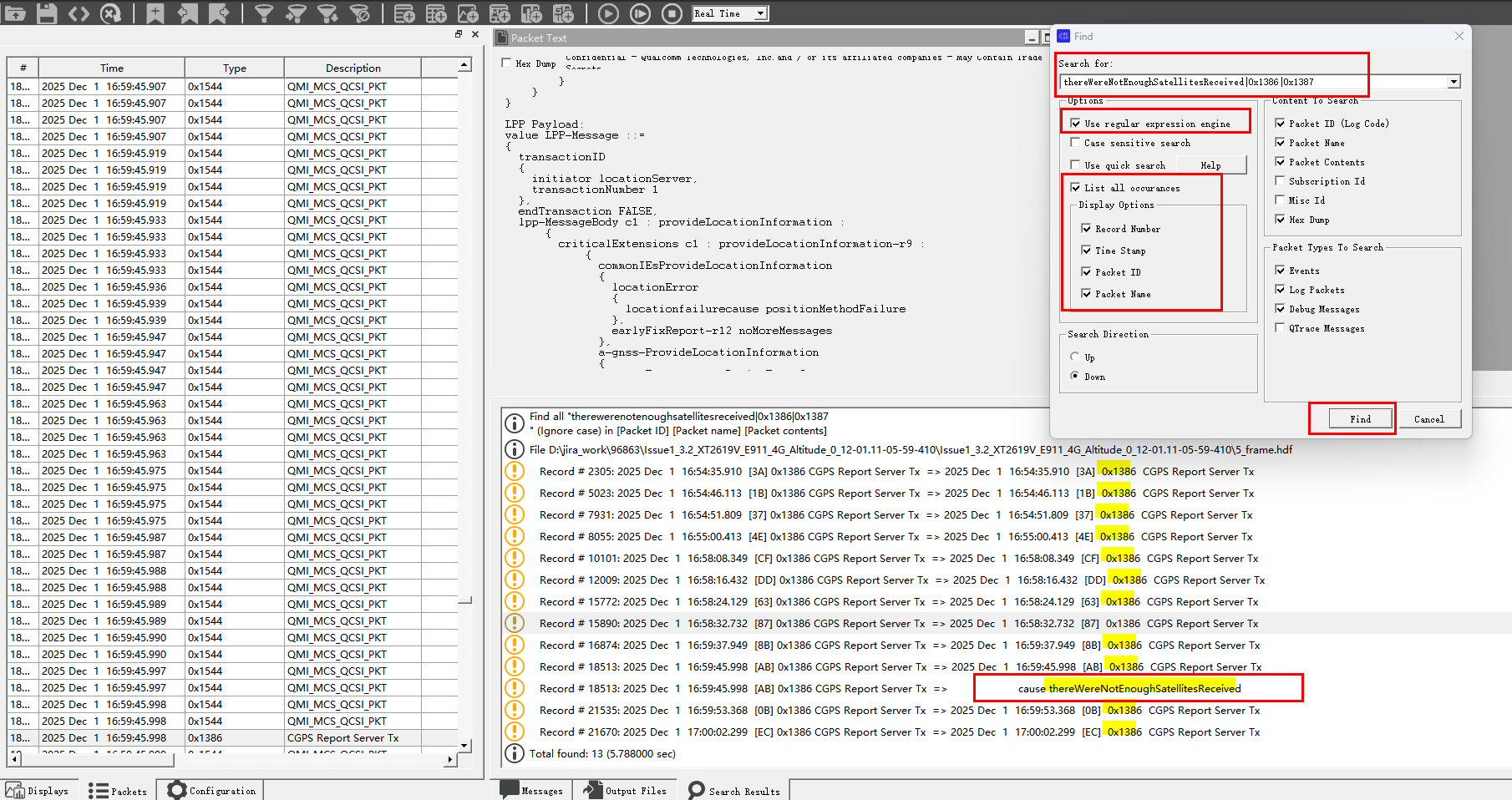
5. 在 QCAT 重新打开 XXX.hdf
Ctrl+F 打开 搜索框, 选中 [] list all occurances 和 Use regular expression enginee 输入正则表达式搜素
后点击OK 就能批量显示搜索到的匹配文本 item log
════════════════════════════════
thereWereNotEnoughSatellitesReceived|0x1386|0x1387
════════════════════════════════
AGPS_Qcom_Modem_Log_GNSS_字段说明
Qcom_0x1386 CGPS Report Server Tx 解析
════════════════Log Packets :  GNSS  : 0x1386  CGPS Report Server Tx  ════════════════════


// 该字段表示是否要求接收方发送LPP协议的确认消息(ACK)。当值为FALSE时,表示当前消息不需要接收方发送确认回复
//在LPP协议中,若消息仅用于单向传递信息或本身是确认消息时,可能将ackRequested设为FALSE以避免冗余通信
══════ ackRequested FALSE,

//该字段表示被确认消息的序列号(即需要确认的目标消息的编号)。此处值为11,说明当前消息是对某个序列号为11的先前消息
// 某个序列号为11对应的格式是  sequenceNumber 11,
══════ ackIndicator 11

//标记当前设备支持的GNSS定位系统种类  枚举 [ gps  sbas qzss_日本准天顶星基增强系统  galileo glonass bds ]
══════   gnss-ID { gnss-id gps } 【gnss-SupportList 】

// 标记当前设备支持的GPS启动模式  standalone独立定位   MSB_ue-based_设备为主定位     MSA_ue-assisted_设备为辅定位
══════   agnss-Modes { posModes { standalone, ue-based, ue-assisted } },【gnss-SupportList 】


// 标记当前设备由于没有足够的卫星信号导致的无法完成定位 进而无法提供给网络TE_NW 位置信息
══════ cause thereWereNotEnoughSatellitesReceived  【a-gnss-ProvideLocationInformation】


// errorCause:定义错误的原因 LPP中定义了如下枚举 错误类型
//  1.undefined:未定义的错误原因
//  2.lppMessageHeaderError:表示接收器在LPP消息头中检测到编码错误(即公共字段)
//  3.lppMessageBodyError:表示接收器在LPP消息正文中检测到编码错误
//  4.epduError:表示接收器在EPDU(External Protocol Data Unit)中检测到编码错误
//  5.lppSegmentationError:表示接收器在LPP消息分割中检测到的错误
//  6.incorrectDataValue:表示接收到的数据值不正确
══════errorCause incorrectDataValue   【commonIEsError】


══════════════════════════════════════════════════════════════════════════════════════════
Qcom_0x1387_CGPS Report Server Rx 帧解析
════════════════Log Packets :  GNSS  : 0x1387  CGPS Report Server Rx  ════════════════════


// 用于TE测试环境_NW网络端  向 UE DUT 设备发送请求 GPS 能力的字段
══════criticalExtensions c1 : requestCapabilities-r9


// 用于TE测试环境_NW网络端  向 UE DUT 设备发送请求 GPS 位置的请求字段
══════ criticalExtensions c1 : requestLocationInformation-r9 :

// 用于TE测试环境_NW网络端  向 UE DUT 设备发送 请求 GPS 位置的响应时间
══════   responseTime { time 20 } 【requestLocationInformation】


// TE_NW网络端提供给 DUT 设备的卫星状态辅助数据(用于加快GPS搜星定位)
══════      a-gnss-ProvideAssistanceData
              {
                gnss-CommonAssistData
                {
                  // satelliteID(标识特定GPS卫星),tlmWord(携带GPS卫星广播的TLM_ Telemetry 遥测消息数据,解析tlmWord可获取卫星的状态信息),antiSpoof(防欺骗标志),alert(警报标志),tlmRsvdBits(保留位)
                  4_1: gnss-ReferenceTime,      // 指定GNSS系统时间或网络时间
                  4_2: gnss-ReferenceLocation,  // 参考位置 经纬度  latitudeSign north, degreesLatitude 4437220, degreesLongitude -5701087
                  4_3: gnss-IonosphericModel,   //电离层模型 (Ionospheric Model) 是用于描述GNSS信号在电离层中的传播延迟

                  //辅助卫星数据 iod(Issue of Data)用于计算修正差分数据,
                  // NAV-ClockModel 是 GNSS-ClockModel的一种,用于描述导航卫星的时钟信息 navTo: 周内时钟数据参考时间单位为秒  navAf2:导航电文中的时钟偏差率 navAf0:导航电文中的时钟偏差 navTgd:群延迟校正
                  // gnss-OrbitModel 是一个选择字段,包含多个子字段,如keplerianSet(gps)、cnav-KeplerianSet、glonass-ECEF(glonass)、sba-ECEF等。这些子字段分别对应不同的卫星导航系统(如GPS、GLONASS、BDS等)的轨道模型描述
                  // nav-KeplerianSet 是LPP协议中用于描述卫星轨道参数的序列  该序列包含多个参数
                  // toe (时间至过顶): 取值范围为0到65536秒      URAI(无用距离精度指标):取值范围为0到15米
                  // ΔN(平均近似偏率)   M0(初始真近点角)    OmegaDot(升交点赤经变化率)   E(偏心率)
                  // i0(初始倾角)       Omega0(初始升交点赤经)    Crs Cis(余弦和正弦谐波校正项)
                  4_4: gnss-GenericAssistData   //辅助卫星数据 iod(Issue of Data)用于计算修正差分数据,
                }
              }


══════════════════════════════════════════════════════════════════════════════════════════
0x1477 GNSS GPS Measurement Report 帧解析
════════════════Log Packets :  GNSS  :  0x1477  GNSS GPS Measurement Report  ════════════════════


// 当前的 GPS 周时间
// https://www.labsat.co.uk/index.php/cn/customer-profiles/252-calculators-cn  GPS 周时间   计算器
// 2123  ---> 2020.9.13
══════ GpsWeek = 2123 [0x084B]


//  Sv  (Satellite Number) 卫星编号,表示接收信号的GPS卫星编号
//  Os (Orbit State) :轨道状态,与卫星的轨道参数相关
//  Elv (Elevation) :仰角,表示天线与卫星之间的垂直角度
//  Azi (Azimuth) :方位角,表示天线与卫星之间的水平角度
//  Stat (Status) :状态,可能表示信号的有效性或接收状态(如有效或无效)
//  Gd (Geometry Dilution of Precision) :几何精度稀释因子,表示定位精度受卫星几何分布的影响程度
//  Tot (Total Number of Satellites) :总卫星数,表示当前接收的卫星总数
//  CNo (Carrier-to-Noise Ratio) :载噪比,表示信号强度与噪声的比值,是衡量信号质量的重要指标
//  Latency (延迟) :延迟时间,可能指信号从卫星到达接收器的时间
//  Pre (Pseudorange) :伪距,表示从接收器到卫星的距离估计值
//  Post (Post-Processed Pseudorange) :后处理伪距,经过校正后的伪距
//  Ms (Multipath) :多径效应,表示信号因反射或折射而产生的误差
//  SubMs (Sub-meter Multipath) :亚米级多径效应,更精确的多径误差测量
//  TUnc (Time Uncertainty) :时间不确定性,表示定位时间的误差范围
//  Speed (速度) :速度,表示接收器的移动速度,通常以公里/小时或节为单位
//  SpdUnc (Speed Uncertainty) :表示速度测量的精度或误差范围
//  Multipath:多径效应, 指GPS信号在传播过程中被反射或绕射,导致接收信号中包含多个路径成分的现象  这种效应会干扰信号的准确性,尤其是在城市密集区域或建筑物附近。多径效应会影响定位精度和速度测量的准确性
//  CSlip:滑移率(Slip Rate),通常用于描述车辆轮胎与地面之间的滑动程度。在GPS导航系统中,滑移率可能影响速度测量的准确性
//  CarrPhase:载波相位(Carrier Phase),是GPS信号中用于高精度定位的关键参数之一。载波相位测量能够提供毫米级的定位精度,广泛应用于静态和动态测量场景
══════ |  #|Sv|Os|Elv|Azi|      Stat|Gd|Tot| CNo|Latency|Pre|Post|       Ms|     SubMs|    TUnc|  Speed|SpdUnc|Multipath|CSlip|CarrPhase|


══════ 0x1477  GNSS GPS Measurement Report 帧示例
2024 Oct 21  12:30:09.911  [56]  0x1477  GNSS GPS Measurement Report
    Version = 0 [0x00]
    RefFCount = 2933206 [0x002CC1D6]
    GpsWeek = 2123 [0x084B]
    GpsMsec = 430818413 [0x19ADC46D]
    ClkTimeBias = 0.2181 [0x3E5F60C6]
    ClkTimeUnc (Ns) = 0.0000 [0x37C5C020]
    ClkFreqBias (m/s) = -0.7310 [0xBF3B22BF]
    ClkFreqUnc (m/s) = 2.9348 [0x403BD340]
    NumValidReports = 13 [0x0D]
    Measurement Report:
    ----------------------------------------------------------------------------------------------------------------------------------
    |  #|Sv|Os|Elv|Azi|      Stat|Gd|Tot| CNo|Latency|Pre|Post|       Ms|     SubMs|    TUnc|  Speed|SpdUnc|Multipath|CSlip|CarrPhase|
    ----------------------------------------------------------------------------------------------------------------------------------
    |  0| 1| 5| 56|291|0x0824007F|18| 18|29.9|    -27| 20|  47|430818342|0.83465809|0.000136|-157.04|   0.4|      N/A|    0| 0.000000|
    |  1| 3| 5| 26|303|0x082400FF|18| 18|30.1|    -14| 20|  47|430818335|0.46960747|0.000136|-525.13|   0.4|      N/A|    0| 0.000000|
    |  2| 4| 5| 11|246|0x0824007F|18| 18|29.8|    -19| 20|  47|430818330|0.42837116|0.000136|-561.98|   0.4|      N/A|    0| 0.000000|
    |  3|11| 5| 40|237|0x0824007F|18| 18|29.9|    -29| 20|  47|430818340|0.14368388|0.000136| 389.74|   0.4|      N/A|    0| 0.000000|
    |  4|21| 5| 43|182|0x082400FF|18| 18|29.8|    -10| 20|  47|430818339|0.45280734|0.000136| 458.98|   0.4|      N/A|    0| 0.000000|
    |  5|22| 5| 48|311|0x082400FF|18| 18|30.1|    -30| 20|  47|430818339|0.77031416|0.000136|-387.30|   0.4|      N/A|    0| 0.000000|
    |  6|31| 5| 59|123|0x082400FF|18| 18|30.1|    -26| 20|  47|430818343|0.80437380|0.000136|-189.47|   0.4|      N/A|    0| 0.000000|
    |  7|32| 5| 43| 48|0x082400FF|18| 18|30.0|    -29| 20|  47|430818340|0.08794296|0.000136| 430.52|   0.4|      N/A|    0| 0.000000|
    |  8| 8| 1|  5|222|0x00200617| 0|  0| 0.0|  11077|  0|   0|430818328|0.27520707|0.000866| 520.98|  21.6|      N/A|    0| 0.000000|
    |  9|10| 1| 18|104|0x00200617| 0|  0| 0.0|  11117|  0|   0|430818332|0.95910895|0.000871| 504.85|  21.7|      N/A|    0| 0.000000|
    | 10|17| 1|  1|330|0x00200617| 0|  0| 0.0|  11117|  0|   0|430818326|0.09122809|0.000872|-236.13|  21.7|      N/A|    0| 0.000000|
    | 11|25| 1|  6| 68|0x00200617| 0|  0| 0.0|  11077|  0|   0|430818329|0.87864977|0.000866|-214.82|  21.6|      N/A|    0| 0.000000|
    | 12|26| 1|  0|147|0x00200617| 0|  0| 0.0|  11117|  0|   0|430818327|0.60269785|0.000872|-505.27|  21.7|      N/A|    0| 0.000000|
    ----------------------------------------------------------------------------------------------------------------------------------
0x1478 GNSS Clock Report 帧解析
════════════════Log Packets :  GNSS  : 0x1478  GNSS Clock Report  ════════════════════


   Valid Flag = 127
   RefFCount = 2469920
   GPS Week = 2123
   GPS Msec = 431257425
...
                               // w_MinGpsWeekNumber 在测试模拟之前时间的GPS信号时 可能需要设置为  1738
   w_MinGpsWeekNumber = 1738   // 当前 GPS 翻牌值 在 NV#6264 中定义  【6264,CGPS Minimum GPS Week Number,cgps_minimum_gps_week_number,GPS】
0x1886 GNSS GAL Measurement Report 伽利略信号策略帧解析
Log Packets :  GNSS  : 0x1886  GNSS GAL Measurement Report   【 Report_Galileo 欧洲伽利略定位系统 信号 测量报告 】


2025 Feb 13  01:33:03.717  [F8]  0x1886  GNSS GAL Measurement Report
Version = 2
Version 2
   EngineType = Gen9 (6)
   HwVersion = 10
   ClockInfo {
      RefFCount = 6476498 ms
      Time {

	  //   GalWeek = 1099  对应  GPS Week Number = 2123   【 1099+1024=2123 】
         GalWeek = 1099      【伽利略周数】 伽利略的参考时间是1999年8月22日 , 提到Galileo的周零对应GPS周数的1024周
         GalMsec = 430823226
         ClkTimeBias =    2.3221154511e-001
         ClkTimeUncMs =    8.0000180664e+003
      }
      Freq {
         ClkFreqBias =    1.1710642576e+000
         ClkFreqUnc =    8.1319808960e+001
      }
   }
   NumValidReports = 0
azimuth_Azi_卫星方位角
卫星的方位角(azimuth of satellites)
是描述卫星在水平方向上相对于观察者位置的角度量:

卫星方位角是从正北方向开始的,是真北与卫星和地面成像点之间的垂直圆之间的角度
方位角的基准是正北,顺时针测量,东侧为正,西侧为负,范围是±180度
方位角是卫星方向在水平面上的角度,从地理北顺时针测量,范围0到360度

常用句型:
UE was NOT able to get azimuth of satellites
设备无法获取卫星方位角

通常范围为0°至360° , 但也有用±180°表示,东侧为正值(0°至180°),西侧为负值(0°至-180°)。


Qcom_Modem Log 关键字

0x1477  GNSS GPS Measurement Report

Measurement Report:
-------------------
|  #|Sv|Os|Elv【仰角】|Azi【方位角】|
-------------------	-------------------
|  0| 1| 5|        -90|            0|
|  1| 3| 5|        -90|            0|
|  2| 4| 5|        -90|            0|
|  3|11| 5|          8|          268|
|  4|21| 5|        -90|            0|
|  5|22| 5|        -90|            0|
|  6|31| 5|        -90|            0|
|  7|32| 5|        -90|            0|
-------------------------------------
Elevation_Satellites(Elv)_卫星仰角
Elevation 仰角 也就是观察者与卫星之间的连线与水平面的夹角。
通常仰角范围在0到90度之间,0度表示卫星位于地平线,90度表示卫星在正上方


GNSS接收器的仰角掩码参数允许设置为-90到90度,但默认是5度,排除低于该值的卫星
在某些设备设置中,仰角可以设置为负数,但实际应用中通常不会使用负值,因为卫星不可能出现在地平线以下。
仰角可以设置为负数---- >  仅用于排除低仰角卫星(例如默认掩码为5°)


elevation of satellites were almost -90

常用句型:
the elevation of satellites were almost -90
设备搜素到的卫星仰角几乎都是-90 (不被侦测到的卫星)


Qcom_Modem Log 关键字

0x1477  GNSS GPS Measurement Report

Measurement Report:
-------------------
|  #|Sv|Os|Elv【仰角】|Azi【方位角】|
-------------------	-------------------
|  0| 1| 5|        -90|            0|
|  1| 3| 5|        -90|            0|
|  2| 4| 5|        -90|            0|
|  3|11| 5|          8|          268|
|  4|21| 5|        -90|            0|
|  5|22| 5|        -90|            0|
|  6|31| 5|        -90|            0|
|  7|32| 5|        -90|            0|
-------------------------------------
Qcom_DMC_QXDM过滤文件列表结婚
AGPS_Fliter_1.dmc
AGPS_Fliter_1.dmc  包含的过滤条件

-------------------------------------------
Event Reports
-------------------------------------------
[0x1428] EVENT_IMS_SIP_SESSION_START
[0x1429] EVENT_IMS_SIP_SESSION_RINGING
[0x1430] EVENT_IMS_SIP_SESSION_ESTABLISHED
[0x1431] EVENT_IMS_SIP_SESSION_TERMINATED


-------------------------------------------
Log Packets
-------------------------------------------
[0x1387] CGPS Report Server Rx
[0x1386] CGPS Report Server Tx


-------------------------------------------
Log Packets (OTA)
-------------------------------------------
[0x156E] IMS SIP Message
[0x1830] IMS VoLTE Session Setup
[0x1831] IMS VoLTE Session End
复制该block内容 重命名为 【 AGPS_Fliter_1.dmc 】 在 QXDM 中Ctrl+M选中该文件 打开新的Fliter-View 右击执行 refreshView 开始执行过滤
<QXDMProfessional>
 <Persistence>
  <Displays>
   <Display0>
    <Frame>
     <Show>1</Show>
     <PosX>0</PosX>
     <PosY>0</PosY>
     <SizeWidth>400</SizeWidth>
     <SizeHeight>200</SizeHeight>
    </Frame>
    <Type>Filtered View</Type>
    <SUB>Filtered View</SUB>
    <View>
     <ISVConfig>
      <Items>4,5,8</Items>
      <DIAGRequests></DIAGRequests>
      <DIAGResponses></DIAGResponses>
      <SubsystemRequests></SubsystemRequests>
      <SubsystemResponses></SubsystemResponses>
      <SubsystemV2Requests></SubsystemV2Requests>
      <SubsystemV2ImmediateResponses></SubsystemV2ImmediateResponses>
      <SubsystemV2DelayedResponses></SubsystemV2DelayedResponses>
      <EventIDs>01431,01430,01429,01428</EventIDs>
      <LogCodes>0x1831,0x1830,0x1387,0x1386</LogCodes>
      <OTATypes>0x156E</OTATypes>
      <MessageLevels></MessageLevels>
      <StringTypes></StringTypes>
      <QTraces></QTraces>
      <QSHMetrics></QSHMetrics>
      <QSHEvents></QSHEvents>
     </ISVConfig>
    </View>
   </Display0>
  </Displays>
  <LoggingView>
   <ISVConfig>
    <Items>4</Items>
    <DIAGRequests></DIAGRequests>
    <DIAGResponses></DIAGResponses>
    <SubsystemRequests></SubsystemRequests>
    <SubsystemResponses></SubsystemResponses>
    <SubsystemV2Requests></SubsystemV2Requests>
    <SubsystemV2ImmediateResponses></SubsystemV2ImmediateResponses>
    <SubsystemV2DelayedResponses></SubsystemV2DelayedResponses>
    <EventIDs>03406,03278,03246,03214,03182,03150,03118,03086,03054,03022,02990,02958,02926,02894,02862,02830,02798,02766,02734,02702,02670,02638,02606,02574,01262,01230,01198,01166,01134,01102,01038,01006,00974,00942,00910,00878,00846,00814,00782,00302,00270,00334,00366,00398,00430,00462,00494,00526,00558,00590,00622,00654,00686,00718,00750,01294,01326,01358,01390,01422,01454,01486,01518,01550,01582,01614,01646,01678,01710,01742,01774,01806,01838,01870,01902,01934,01966,01998,02030,02062,02094,02126,02158,02190,02222,02254,02478,02510,02542,03454,03326,03294,03262,03230,03198,03166,03134,03102,03070,03038,03006,02974,02942,02910,02878,02846,02814,02782,02750,02718,02686,02654,02622,02590,02558,01278,01246,01214,01182,01150,01118,01086,01054,01022,00990,00958,00926,00894,00862,00830,00798,00318,00286,00350,00382,00414,00446,00478,00510,00542,00574,00606,00638,00670,00702,00734,00766,01310,01342,01406,01438,01470,01502,01534,01566,01598,01630,01662,01694,01726,01758,01790,01822,01854,01886,01918,01950,01982,02014,02046,02078,02110,02142,02174,02206,02238,02462,02494,02526,03398,03366,03334,03302,03270,03238,03206,03174,03142,03110,03078,03046,03014,02982,02950,02918,02854,02822,02790,02758,02726,02694,02662,02630,02598,02566,01254,01222,01190,01158,01126,01094,01062,01030,00998,00966,00934,00902,00870,00838,00806,00774,00294,00262,00326,00358,00390,00422,00454,00486,00518,00550,00582,00614,00646,00678,00710,00742,01286,01318,01350,01382,01414,01446,01478,01510,01542,01574,01606,01638,01670,01702,01734,01766,01798,01830,01862,01894,01926,01958,01990,02022,02054,02086,02118,02150,02182,02246,02470,02502,02534,03350,03318,03286,03254,03222,03190,03158,03126,03094,03062,03030,02998,02966,02934,02902,02870,02838,02806,02774,02742,02710,02678,02646,02614,02582,02550,01270,01238,01206,01174,01142,01110,01078,01046,01014,00982,00950,00918,00886,00854,00822,00790,00310,00278,00342,00374,00406,00438,00470,00502,00534,00566,00598,00630,00662,00694,00726,00758,01302,01334,01398,01430,01462,01494,01526,01558,01590,01622,01654,01686,01718,01750,01782,01814,01846,01878,01910,01942,01974,02006,02070,02102,02134,02166,02198,02230,02486,02518,03394,03330,03298,03266,03234,03202,03170,03138,03106,03074,03042,03010,02978,02946,02914,02882,02850,02818,02786,02754,02722,02690,02658,02626,02594,02562,01282,01250,01218,01186,01122,01090,01058,01026,00994,00962,00930,00898,00866,00834,00802,00770,00290,00258,00322,00354,00386,00418,00450,00482,00514,00546,00578,00610,00642,00674,00706,00738,01314,01346,01378,01410,01442,01474,01506,01538,01570,01602,01634,01666,01698,01730,01762,01794,01826,01858,01890,01922,01954,01986,02018,02050,02082,02114,02146,02178,02210,02242,02466,02498,02530,03442,03410,03378,03314,03282,03250,03218,03186,03154,03122,03090,03058,03026,02994,02962,02930,02898,02866,02834,02802,02770,02738,02706,02674,02642,02610,02578,02546,01266,01234,01202,01170,01138,01106,01074,01042,01010,00978,00946,00914,00882,00850,00818,00786,00306,00274,00338,00370,00402,00434,00466,00498,00530,00562,00594,00626,00658,00690,00722,00754,01298,01330,01394,01426,01458,01490,01522,01554,01586,01618,01650,01682,01714,01746,01778,01810,01842,01874,01906,01938,01970,02002,02034,02066,02098,02130,02162,02194,02226,02258,02482,02514,03434,03402,03370,03338,03306,03274,03242,03210,03178,03146,03114,03082,03050,03018,02986,02954,02922,02890,02858,02826,02794,02762,02730,02698,02666,02634,02602,02570,01258,01226,01194,01162,01130,01098,01066,01034,01002,00970,00938,00906,00874,00842,00810,00778,00298,00266,00330,00362,00394,00426,00458,00490,00522,00554,00586,00618,00650,00682,00714,00746,01290,01322,01354,01386,01418,01450,01482,01514,01546,01578,01610,01642,01674,01706,01738,01770,01802,01834,01866,01898,01930,01962,01994,02026,02058,02090,02122,02154,02186,02250,02474,02506,02538,03450,03354,03290,03258,03226,03194,03162,03130,03098,03066,03034,03002,02970,02938,02906,02874,02842,02810,02778,02746,02714,02682,02650,02618,02586,02554,01274,01242,01210,01178,01146,01114,01082,01050,01018,00986,00954,00922,00890,00858,00826,00794,00314,00282,00346,00378,00410,00442,00474,00506,00538,00570,00602,00634,00666,00698,00730,00762,01306,01338,01402,01434,01466,01498,01530,01562,01594,01626,01658,01690,01722,01754,01786,01818,01850,01882,01914,01946,01978,02010,02042,02074,02106,02138,02170,02202,02234,02490,02522,03405,03309,03277,03245,03213,03181,03149,03117,03085,03053,03021,02989,02957,02925,02893,02861,02829,02797,02765,02733,02701,02669,02637,02605,02573,01261,01229,01197,01165,01133,01101,01069,01037,01005,00973,00941,00909,00877,00845,00813,00781,00301,00269,00333,00365,00397,00429,00461,00493,00525,00557,00589,00621,00653,00685,00717,00749,01293,01325,01357,01389,01421,01453,01485,01517,01549,01581,01613,01645,01677,01709,01741,01773,01805,01837,01869,01901,01933,01965,01997,02029,02061,02093,02125,02157,02189,02253,02477,02509,02541,03453,03389,03325,03293,03261,03229,03197,03165,03133,03101,03069,03037,03005,02973,02941,02909,02877,02845,02813,02781,02749,02717,02685,02653,02621,02589,02557,01277,01245,01213,01181,01149,01117,01085,01053,01021,00989,00957,00925,00893,00861,00829,00797,00317,00285,00349,00381,00413,00445,00477,00509,00541,00573,00605,00637,00669,00701,00733,00765,01309,01341,01405,01437,01469,01501,01533,01565,01597,01629,01661,01693,01725,01757,01789,01821,01853,01885,01917,01949,01981,02013,02045,02077,02109,02141,02173,02205,02237,02461,02493,02525,03397,03365,03333,03301,03269,03237,03205,03173,03141,03109,03077,03045,03013,02981,02949,02917,02885,02853,02821,02789,02757,02725,02693,02661,02629,02597,02565,01253,01221,01189,01157,01125,01093,01061,01029,00997,00965,00933,00901,00869,00837,00805,00773,00293,00261,00325,00357,00389,00421,00453,00485,00517,00549,00581,00613,00645,00677,00709,00741,01285,01317,01349,01381,01413,01445,01477,01509,01541,01573,01605,01637,01669,01701,01733,01765,01797,01829,01861,01893,01925,01957,01989,02021,02053,02085,02117,02149,02181,02245,02469,02501,02533,03445,03381,03349,03317,03285,03253,03221,03189,03157,03125,03093,03061,03029,02997,02965,02933,02901,02869,02837,02805,02773,02741,02709,02677,02645,02613,02581,02549,01269,01237,01205,01173,01141,01109,01077,01045,01013,00981,00949,00917,00885,00853,00821,00789,00309,00277,00341,00373,00405,00437,00469,00501,00533,00565,00597,00629,00661,00693,00725,00757,01301,01333,01397,01429,01461,01493,01525,01557,01589,01621,01653,01685,01717,01749,01781,01813,01845,01877,01909,01941,01973,02005,02069,02101,02133,02165,02197,02229,02485,02517,03393,03329,03297,03265,03201,03169,03137,03105,03073,03041,03009,02977,02945,02913,02881,02849,02817,02785,02753,02721,02689,02657,02625,02593,02561,01281,01249,01217,01185,01121,01089,01057,01025,00993,00961,00929,00897,00865,00833,00801,00769,00289,00257,00321,00353,00385,00417,00449,00481,00513,00545,00577,00609,00641,00673,00705,00737,01313,01345,01377,01409,01441,01473,01505,01537,01569,01601,01633,01665,01697,01729,01761,01793,01825,01857,01889,01921,01953,01985,02017,02049,02081,02113,02145,02177,02209,02241,02465,02497,02529,03409,03377,03281,03249,03217,03185,03153,03121,03089,03057,03025,02993,02961,02929,02897,02865,02833,02801,02769,02737,02705,02673,02641,02609,02577,02545,01265,01233,01201,01169,01137,01105,01073,01041,01009,00977,00945,00913,00881,00849,00817,00785,00305,00273,00337,00369,00401,00433,00465,00497,00529,00561,00593,00625,00657,00689,00721,00753,01297,01329,01393,01425,01457,01489,01521,01553,01585,01617,01649,01681,01713,01745,01777,01809,01841,01873,01905,01937,01969,02001,02033,02065,02097,02129,02161,02193,02225,02257,02481,02513,03433,03401,03369,03337,03305,03273,03241,03209,03177,03145,03113,03081,03049,03017,02985,02953,02921,02889,02857,02825,02793,02761,02729,02697,02665,02633,02601,02569,01257,01225,01193,01161,01129,01097,01065,01033,01001,00969,00937,00905,00873,00841,00809,00777,00297,00265,00329,00361,00393,00425,00457,00489,00521,00553,00585,00617,00649,00681,00713,00745,01289,01321,01353,01385,01417,01449,01481,01513,01545,01577,01609,01641,01673,01705,01737,01769,01801,01833,01865,01897,01929,01961,01993,02025,02057,02089,02121,02153,02185,02249,02473,02505,02537,03449,03385,03353,03321,03289,03225,03193,03161,03129,03097,03065,03033,03001,02969,02937,02905,02873,02841,02809,02777,02745,02713,02681,02649,02617,02585,02553,01273,01241,01209,01177,01145,01113,01081,01049,01017,00985,00953,00921,00889,00857,00825,00793,00313,00281,00345,00377,00409,00441,00473,00505,00537,00569,00601,00633,00665,00697,00729,00761,01305,01337,01433,01465,01497,01529,01561,01593,01625,01657,01689,01721,01753,01785,01817,01849,01881,01913,01945,01977,02009,02041,02073,02105,02137,02169,02201,02233,02489,02521,03428,03396,03364,03332,03300,03268,03204,03172,03140,03108,03076,03044,03012,02980,02948,02916,02884,02852,02820,02788,02756,02724,02692,02660,02628,02596,02564,01284,01252,01220,01188,01156,01124,01092,01060,01028,00996,00964,00932,00900,00868,00836,00804,00772,00292,00260,00324,00356,00388,00420,00452,00484,00516,00548,00580,00612,00644,00676,00708,00740,01316,01348,01380,01412,01444,01476,01508,01540,01572,01604,01636,01668,01700,01732,01764,01796,01828,01860,01892,01924,01956,01988,02020,02052,02084,02116,02148,02180,02244,02468,02500,02532,03444,03380,03284,03252,03220,03188,03156,03124,03092,03060,03028,02996,02964,02932,02900,02868,02836,02804,02772,02740,02708,02676,02644,02612,02580,02548,01268,01236,01204,01172,01140,01108,01076,01044,01012,00980,00948,00916,00884,00852,00820,00788,00308,00276,00340,00372,00404,00436,00468,00500,00532,00564,00596,00628,00660,00692,00724,00756,01300,01332,01396,01428,01460,01492,01524,01556,01588,01620,01652,01684,01716,01748,01780,01812,01844,01876,01908,01940,01972,02004,02068,02100,02132,02164,02196,02228,02484,02516,03404,03372,03308,03276,03244,03212,03180,03148,03116,03084,03052,03020,02988,02956,02924,02892,02860,02828,02796,02764,02732,02700,02668,02636,02604,02572,01260,01228,01196,01164,01132,01100,01068,01036,01004,00972,00940,00908,00876,00844,00812,00780,00300,00268,00332,00364,00396,00428,00460,00492,00524,00556,00588,00620,00652,00684,00716,00748,01292,01324,01356,01388,01420,01452,01484,01516,01548,01580,01612,01644,01676,01708,01740,01772,01804,01836,01868,01900,01932,01964,01996,02028,02060,02092,02124,02156,02188,02252,02476,02508,02540,03388,03324,03292,03260,03228,03196,03164,03132,03100,03068,03036,03004,02972,02940,02908,02876,02844,02812,02780,02748,02716,02684,02652,02620,02588,02556,01276,01244,01212,01180,01148,01116,01084,01052,01020,00988,00956,00924,00892,00860,00828,00796,00316,00284,00348,00380,00412,00444,00476,00508,00540,00572,00604,00636,00668,00700,00732,00764,01308,01340,01404,01436,01468,01500,01532,01564,01596,01628,01660,01692,01724,01756,01788,01820,01852,01884,01916,01948,01980,02012,02044,02076,02108,02140,02172,02204,02236,02460,02492,02524,03392,03296,03264,03232,03200,03168,03136,03104,03072,03040,03008,02976,02944,02912,02880,02848,02816,02784,02752,02720,02688,02656,02624,02592,02560,01280,01248,01216,01184,01120,01088,01056,01024,00992,00960,00928,00896,00864,00832,00800,00768,00288,00000,00256,00320,00352,00384,00416,00448,00480,00512,00544,00576,00608,00640,00672,00704,00736,01312,01344,01376,01408,01440,01472,01504,01536,01568,01600,01632,01664,01696,01728,01760,01792,01824,01856,01888,01920,01952,01984,02016,02080,02112,02144,02176,02208,02240,02464,02496,02528,03408,03280,03248,03216,03184,03152,03120,03088,03056,03024,02992,02960,02928,02896,02864,02832,02800,02768,02736,02704,02672,02640,02608,02576,02544,01264,01232,01200,01168,01136,01104,01072,01040,01008,00976,00944,00912,00880,00848,00816,00784,00304,00272,00336,00368,00400,00432,00464,00496,00528,00560,00592,00624,00656,00688,00720,00752,01296,01328,01392,01424,01456,01488,01520,01552,01584,01616,01648,01680,01712,01744,01776,01808,01840,01872,01904,01936,01968,02000,02032,02064,02096,02128,02160,02192,02224,02256,02480,02512,03432,03368,03336,03304,03272,03240,03208,03176,03144,03112,03080,03048,03016,02984,02952,02920,02888,02856,02824,02792,02760,02728,02696,02664,02632,02600,02568,01256,01224,01192,01160,01128,01096,01064,01032,01000,00968,00936,00904,00872,00840,00808,00776,00296,00264,00328,00360,00392,00424,00456,00488,00520,00552,00584,00616,00648,00680,00712,00744,01288,01320,01352,01384,01416,01448,01480,01512,01544,01576,01608,01640,01672,01704,01736,01768,01800,01832,01864,01896,01928,01960,01992,02024,02056,02088,02120,02152,02184,02248,02472,02504,02536,03448,03352,03320,03288,03224,03192,03128,03096,03064,03032,03000,02968,02936,02904,02872,02840,02808,02776,02744,02712,02680,02648,02616,02584,02552,01272,01240,01208,01176,01144,01112,01080,01048,01016,00984,00952,00920,00888,00856,00824,00792,00312,00280,00344,00376,00408,00440,00472,00504,00536,00568,00600,00632,00664,00696,00728,00760,01304,01336,01432,01464,01496,01528,01560,01592,01624,01656,01688,01720,01752,01784,01816,01848,01880,01912,01944,01976,02008,02040,02072,02104,02136,02168,02200,02232,02488,02520,03395,03331,03299,03267,03203,03171,03139,03107,03075,03043,03011,02979,02947,02915,02883,02851,02819,02787,02755,02723,02691,02659,02627,02595,02563,01283,01251,01219,01187,01123,01091,01059,01027,00995,00963,00931,00899,00867,00835,00803,00771,00291,00259,00323,00355,00387,00419,00451,00483,00515,00547,00579,00611,00643,00675,00707,00739,01315,01347,01379,01411,01443,01475,01507,01539,01571,01603,01635,01667,01699,01731,01763,01795,01827,01859,01891,01923,01955,01987,02019,02051,02083,02115,02147,02179,02211,02243,02467,02499,02531,03411,03379,03315,03283,03251,03219,03187,03155,03123,03091,03059,03027,02995,02963,02931,02899,02867,02835,02803,02771,02739,02707,02675,02643,02611,02579,02547,01267,01235,01203,01171,01139,01107,01075,01043,01011,00979,00947,00915,00883,00851,00819,00787,00307,00275,00339,00371,00403,00435,00467,00499,00531,00563,00595,00627,00659,00691,00723,00755,01299,01331,01395,01427,01459,01491,01523,01555,01587,01619,01651,01683,01715,01747,01779,01811,01843,01875,01907,01939,01971,02003,02067,02099,02131,02163,02195,02227,02259,02483,02515,03435,03403,03371,03339,03307,03275,03243,03211,03179,03147,03115,03083,03051,03019,02987,02955,02923,02891,02859,02827,02795,02763,02731,02699,02667,02635,02603,02571,01259,01227,01195,01163,01131,01099,01067,01035,01003,00971,00939,00907,00875,00843,00811,00779,00299,00267,00331,00363,00395,00427,00459,00491,00523,00555,00587,00619,00651,00683,00715,00747,01291,01323,01355,01387,01419,01451,01483,01515,01547,01579,01611,01643,01675,01707,01739,01771,01803,01835,01867,01899,01931,01963,01995,02027,02059,02091,02123,02155,02187,02251,02475,02507,02539,03451,03387,03323,03291,03259,03227,03195,03163,03131,03099,03067,03035,03003,02971,02939,02907,02875,02843,02811,02779,02747,02715,02683,02651,02619,02587,02555,01275,01243,01211,01179,01147,01115,01083,01051,01019,00987,00955,00923,00891,00859,00827,00795,00315,00283,00347,00379,00411,00443,00475,00507,00539,00571,00603,00635,00667,00699,00731,00763,01307,01339,01403,01435,01467,01499,01531,01563,01595,01627,01659,01691,01723,01755,01787,01819,01851,01883,01915,01947,01979,02011,02043,02075,02107,02139,02171,02203,02235,02491,02523,03407,03279,03247,03215,03183,03151,03119,03087,03055,03023,02991,02959,02927,02895,02863,02831,02799,02767,02735,02703,02671,02639,02607,02575,01263,01231,01199,01167,01135,01103,01071,01039,01007,00975,00943,00911,00879,00847,00815,00783,00303,00271,00335,00367,00399,00431,00463,00495,00527,00559,00591,00623,00655,00687,00719,00751,01295,01327,01359,01391,01423,01455,01487,01519,01551,01583,01615,01647,01679,01711,01743,01775,01807,01839,01871,01903,01935,01967,01999,02031,02063,02095,02127,02159,02191,02223,02255,02479,02511,02543,03391,03327,03295,03263,03231,03199,03167,03135,03103,03071,03039,03007,02975,02943,02911,02879,02847,02815,02783,02751,02719,02687,02655,02623,02591,02559,01279,01247,01215,01183,01119,01087,01055,01023,00991,00959,00927,00895,00863,00831,00799,00767,00287,00319,00351,00383,00415,00447,00479,00511,00543,00575,00607,00639,00671,00703,00735,01311,01343,01375,01407,01439,01471,01503,01535,01567,01599,01631,01663,01695,01727,01759,01791,01823,01855,01887,01919,01951,01983,02047,02079,02111,02143,02175,02207,02239,02463,02495,02527,03399,03303,03271,03239,03207,03175,03143,03111,03079,03047,03015,02983,02951,02919,02887,02855,02823,02791,02759,02727,02695,02663,02631,02599,02567,01255,01223,01191,01159,01127,01095,01063,01031,00999,00967,00935,00903,00871,00839,00807,00775,00295,00263,00327,00359,00391,00423,00455,00487,00519,00551,00583,00615,00647,00679,00711,00743,01287,01319,01351,01383,01415,01447,01479,01511,01543,01575,01607,01639,01671,01703,01735,01767,01799,01831,01863,01895,01927,01959,01991,02023,02055,02087,02119,02151,02183,02247,02471,02503,02535,03447,03319,03287,03255,03223,03191,03159,03127,03095,03063,03031,02999,02967,02935,02903,02871,02839,02807,02775,02743,02711,02679,02647,02615,02583,02551,01271,01239,01207,01175,01143,01111,01079,01047,01015,00983,00951,00919,00887,00855,00823,00791,00311,00279,00343,00375,00407,00439,00471,00503,00535,00567,00599,00631,00663,00695,00727,00759,01303,01335,01431,01463,01495,01527,01559,01591,01623,01655,01687,01719,01751,01783,01815,01847,01879,01911,01943,01975,02007,02071,02103,02135,02167,02199,02231,02487,02519</EventIDs>
    <LogCodes></LogCodes>
    <OTATypes></OTATypes>
    <MessageLevels></MessageLevels>
    <StringTypes></StringTypes>
    <QTraces></QTraces>
    <QSHMetrics></QSHMetrics>
    <QSHEvents></QSHEvents>
    <RestartOnDisconnect>0</RestartOnDisconnect>
    <DiagnosticLogItems></DiagnosticLogItems>
    <LogFilePath>C:\Users\zhuzj5\AppData\Local\Temp/QXDM/ISF</LogFilePath>
   </ISVConfig>
  </LoggingView>
  <MessagesView>
   <ISVConfig>
    <Items></Items>
    <DIAGRequests></DIAGRequests>
    <DIAGResponses></DIAGResponses>
    <SubsystemRequests></SubsystemRequests>
    <SubsystemResponses></SubsystemResponses>
    <SubsystemV2Requests></SubsystemV2Requests>
    <SubsystemV2ImmediateResponses></SubsystemV2ImmediateResponses>
    <SubsystemV2DelayedResponses></SubsystemV2DelayedResponses>
    <EventIDs></EventIDs>
    <LogCodes></LogCodes>
    <OTATypes></OTATypes>
    <MessageLevels></MessageLevels>
    <StringTypes></StringTypes>
    <QTraces></QTraces>
    <QSHMetrics></QSHMetrics>
    <QSHEvents></QSHEvents>
   </ISVConfig>
  </MessagesView>
  <BuildVersion>5.2.560</BuildVersion>
  <MultiInstance>0</MultiInstance>
  <FixedFontFace></FixedFontFace>
  <FixedFontSize>0</FixedFontSize>
 </Persistence>
</QXDMProfessional>
SUPL报文参数
ULP-Common-Part
ULP-Common-Part (Userplane Location Protocol)_ULP === 用户面位置协议_通用参数部分
| Parameter参数 | Type类型 | Size长度 | Presence存在标志 | Description描述 |
|---|---|---|---|---|
| Message-Length | INTEGER整型 | -不固定 | 必须 | 设置消息长度 |
| Version | SEQUENCE序列值 | -不固定 | 必须 | 设置SUPL协议版本-可选1.0.0和2.0.0 |
| Session-ID | SEQUENCE序列值 | -不固定 | 必须 | 设置SUPL终端(SUPL_Enabled_Terminal)(SET)的-SessionID会话ID-MSISDN-IMSI-SLPSessionID.【不设置SLPSessionID当消息类型是SUPL-START类型】 |
| Message-Payload | CHOICE条件选择值 | -不固定 | 必须 | 用于设置以下消息的组合 |
| SUPL-INIT | SUPLINIT-初始化SUPL类型 | -不固定 | NA_不适用 | 负载使用SUPL-INIT消息 |
| SUPL-START | SUPLSTART-开始SUPL类型 | -不固定 | NA_不适用 | 负载使用SUPL-START消息 |
| SUPL-RESPONSE | SUPLRESPONSE | -不固定 | NA_不适用 | 负载使用SUPL-RESPONSE消息 |
| SUPL-POS-INIT | SUPLPOSINIT | -不固定 | NA_不适用 | 负载使用SUPL-POS-INIT消息 |
| SUPL-POS | SUPLPOS | -不固定 | NA_不适用 | 负载使用SUPL-POS消息 |
| SUPL-END | SUPLEND | -不固定 | NA_不适用 | 负载使用SUPL-END消息 |
| SUPL-AUTH-REQ | SUPLAUTHREQ | -不固定 | NA_不适用 | NA_不适用 |
| SUPL-AUTH-RESP | SUPLAUTHRESP | -不固定 | NA_不适用 | NA_不适用 |
| msSUPLTRIGGEREDSTART | Ver2-SUPLTRIGGEREDSTART触发开始 | -不固定 | 可选 | 不使用该消息 |
| msSUPLTRIGGEREDRESPONSE | Ver2-SUPLTRIGGEREDRESPONSE触发回应 | -不固定 | 可选 | 不使用该消息 |
| msSUPLTRIGGEREDSTOP | Ver2-SUPLTRIGGEREDSTOP触发停止 | -不固定 | 可选 | 不使用该消息 |
| msSUPLNOTIFY | Ver2-SUPLNOTIFY_SUPL提醒 | -不固定 | 可选 | 不使用该消息 |
| msSUPLNOTIFYRESPONSE | Ver2-SUPLNOTIFYRESPONSE_SUPL提醒回应 | -不固定 | 可选 | 不使用该消息 |
| msSUPLSETINIT | Ver2-SUPLSETINIT_设置SUPL初始化 | -不固定 | 可选 | 不使用该消息 |
| msSUPLREPORT | Ver2-SUPLREPORT_SUPL报告 | -不固定 | 可选 | 不使用该消息 |
| Parameter参数 | Type类型 | Size长度 | Presence(1)存在标识 | 设定(1.0) | Presence(2)存在标识 | 设定(2.0) | 描述说明 |
|---|---|---|---|---|---|---|---|
| ULP-PDU | SEQUENCE | - | M | 必须设置 | M | 必须设置 | |
| >length | INTEGER | (0..65535) | M | 必须设置 | M | 必须设置 | 设置消息长度 |
| >version | Version | - | M | 必须设置 | M | 必须设置 | 设置ULP协议的版本 |
| »(Version) | SEQUENCE | - | - | - | - | - | |
| »>maj | INTEGER | (0..255) | M | 必须设置 | M | 必须设置 | Set the ULP protocol version 1.0.0. when the SUPL communication is carried out with ULP1.0. Set the ULP protocol version 2.0.0. when the SUPL communication is carried out with ULP2.0. |
| »>min | INTEGER | (0..255) | M | 必须设置 | M | 必须设置 | Set the minor version 0. |
| »>servind | INTEGER | (0..255) | M | 必须设置 | M | 必须设置 | Set the service indicator 0(in case maj is 1or2) or 4(in case maj is 2). |
| >sessionID | SessionID | - | M | 必须设置 | M | 必须设置 | Set the session number for both the SET and the SLP. 在SET终端和SLP同时设置的SessionID 会话ID |
| »(SessionID) | SEQUENCE | - | - | - | - | - | |
| »>setSessionID | SetSessionID | - | O | 必须设置 | O | 必须设置 | Not set this parameter if the opposed session is unknown in the session start message. (Always set the parameter in case of the SET-Initiated) |
| »»(SetSessionID) | SEQUENCE | - | - | - | - | - | |
| »»>sessionId | INTEGER | (0..65535) | (M) | 必须设置 | (M) | 必须设置 | Set the session number obtained from the SET. 设置从SET终端获取到的SessionNumber |
| »»>setId | SETId | - | (M) | 必须设置 | (M) | 必须设置 | Set the ID for the SET. SLP supports both msisdn and imsi. SET sends either msisdn or imsi. |
| »»»(SETId) | CHOICE | - | - | - | - | - | |
| »»»>msisdn | OCTET STRING | SIZE (8) | ((O)) | 条件设置 | ((O)) | 条件设置 | Set the MSISDN for the SET in BCD. (i.e. if the value is “819012345678,” then it will be 0x180921436587) |
| »»»>mdn | OCTET STRING | SIZE (8) | ((O)) | 不支持 | ((O)) | 不支持 | |
| »»»>min | BIT STRING | SIZE (34) | ((O)) | 不支持 | ((O)) | 不支持 | |
| »»»>imsi | OCTET STRING | SIZE (8) | ((O)) | 条件设置 | ((O)) | 条件设置 | Set the IMSI for the SET in BCD. |
| »»»>nai | IA5String | SIZE (1..1000) | ((O)) | 不支持 | ((O)) | 不支持 | |
| »»»>iPAddress | IPAddress | - | ((O)) | 不支持 | ((O)) | 不支持 | |
| »»»>ver2-imei | OCTET STRING | SIZE (8) | N/A | N/A | ((O)) | 不支持 | |
| »>slpSessionID | SlpSessionID | - | O | 条件设置 | O | 条件设置 | Not set this parameter if the opposed session is unknown in the session start message. Other than this case, always set this parameter. Not set this paramanter in SUPL_START message. Other than this message, always set this parameter. |
| »»(SlpSessionID) | SEQUENCE | - | - | - | - | - | |
| »»>sessionID | OCTET STRING | SIZE (4) | (M) | 条件设置 | (M) | 条件设置 | Set the session number obtained from the SLP. |
| »»>slpId | SLPAddress | - | (M) | 条件设置 | (M) | 条件设置 | Set the ID for the SLP. |
| »»»(SLPAddress) | CHOICE | - | - | - | - | - | |
| »»»>iPAddress | IPAddress | - | ((O)) | 不支持 | ((O)) | 不支持 | |
| »»»»(IPAddress) | CHOICE | - | - | - | - | - | |
| »»»»>ipv4Address | OCTET STRING | SIZE (4) | (((O))) | 忽略设置 | (((O))) | 忽略设置 | |
| »»»»>ipv6Address | OCTET STRING | SIZE (16) | (((O))) | 忽略设置 | (((O))) | 忽略设置 | |
| »»»>fqdn | FQDN | - | ((O)) | 必须设置 | ((O)) | 必须设置 | Set the SLP address. As the ULP session is contained within 1 TCP session, the SET/SLP values are not referred to. If anything other than FQDN is selected (like ipAddress) by SET, the message will be rejected by SLP. If any FQDN is set here, SLP does not care about its value. |
| »»»»(FQDN) | VisibleString(FROM (“a”..”z” | “A”..”Z” | “0”..”9” | “.-“)) | SIZE (1..255) | - | - | - | - | |
| >message | UlpMessage | - | M | 必须设置 | M | 必须设置 | |
| »(UlpMessage) | CHOICE | - | - | - | - | - | |
| »>msSUPLINIT | SUPLINIT | - | (O) | 不支持 | (O) | 不支持 | not accepted by SLP. When yhis message is received at SLP, the connection will be killed by SLP. |
| »>msSUPLSTART | SUPLSTART | - | (O) | 条件设置 | (O) | 条件设置 | |
| »>msSUPLRESPONSE | SUPLRESPONSE | - | (O) | 条件设置 | (O) | 条件设置 | |
| »>msSUPLPOSINIT | SUPLPOSINIT | - | (O) | 条件设置 | (O) | 条件设置 | |
| »>msSUPLPOS | SUPLPOS | - | (O) | 条件设置 | (O) | 条件设置 | |
| »>msSUPLEND | SUPLEND | - | (O) | 条件设置 | (O) | 条件设置 | |
| »>msSUPLAUTHREQ | SUPLAUTHREQ | - | (O) | 不支持 | (O) | 不支持 | not accepted by SLP. When yhis message is received at SLP, the connection will be killed by SLP. |
| »>msSUPLAUTHRESP | SUPLAUTHRESP | - | (O) | 不支持 | (O) | 不支持 | not accepted by SLP. When yhis message is received at SLP, the connection will be killed by SLP. |
| »>msSUPLTRIGGEREDSTART | Ver2-SUPLTRIGGEREDSTART | - | N/A | N/A | (O) | 不支持 | Not used. |
| »>msSUPLTRIGGEREDRESPONSE | Ver2-SUPLTRIGGEREDRESPONSE | - | N/A | N/A | (O) | 不支持 | Not used. |
| »>msSUPLTRIGGEREDSTOP | Ver2-SUPLTRIGGEREDSTOP | - | N/A | N/A | (O) | 不支持 | Not used. |
| »>msSUPLNOTIFY | Ver2-SUPLNOTIFY | - | N/A | N/A | (O) | 不支持 | Not used. |
| »>msSUPLNOTIFYRESPONSE | Ver2-SUPLNOTIFYRESPONSE | - | N/A | N/A | (O) | 不支持 | Not used. |
| »>msSUPLSETINIT | Ver2-SUPLSETINIT | - | N/A | N/A | (O) | 不支持 | Not used. |
| »>msSUPLREPORT | Ver2-SUPLREPORT | - | N/A | N/A | (O) | 不支持 | Not used. |
SUPL-START (MS->NW)
SUPL-START ( Secure User Plane Location Start) 起始SUPL请求消息字段
| Parameter参数 | Type类型 | Size长度 | 1.0存在标识 | 2.0存在标识 | Description描述 |
|---|---|---|---|---|---|
| sETCapabilities | SETCapabilities | 不固定 | 必须 | 必须 | 设置SET终端支持的定位方式_定位协议_首选定位方式【SLP平台将依据都选定位方法确定posMethod的值】 |
| locationId | locationId | 不固定 | 必须 | 必须 | 设置GSM_WCDMA_LTE_NR的定位Cell_LocationID信息 |
| qoP | QoP | 不固定 | NA | 可选 | NA |
| ver2-SUPL-START-extension | Ver2-SUPL-START-extension | 不固定 | NA | 可选 | 未使用 |
| Parameter参数 | Type类型 | Size长度 | Presence(1)存在标识 | 设定(1) | Presence(2)存在标识 | 设定(2) | 描述说明 |
|---|---|---|---|---|---|---|---|
| sETCapabilities | SETCapabilities | - | M | ● | M | ● | Set the positioning technology supported by the SET. |
| >(SETCapabilities) | SEQUENCE | - | - | - | - | - | |
| »posTechnology | PosTechnology | - | M | ● | M | ● | Set the positioning method supported by the SET. |
| »>(PosTechnology) | SEQUENCE | - | - | - | - | - | |
| »»agpsSETassisted | BOOLEAN | - | M | ● | M | ● | Set TRUE if SET has capability of A-GPS SET-assisted. |
| »»agpsSETBased | BOOLEAN | - | M | ● | M | ● | Set TRUE if SET has capability of A-GPS SET-based. |
| »»autonomousGPS | BOOLEAN | - | M | ● | M | ● | SLP does not care this value. |
| »»aflt | BOOLEAN | - | M | ● | M | ● | SLP does not care this value. |
| »»ecid | BOOLEAN | - | M | ● | M | ● | SLP does not care this value. |
| »»eotd | BOOLEAN | - | M | ● | M | ● | SLP does not care this value. |
| »»otdoa | BOOLEAN | - | M | ● | M | ● | SLP does not care this value. |
| »»… | - | - | - | - | - | - | |
| »»ver2-PosTechnology-extension | Ver2-PosTechnology-extension | - | N/A | N/A | O | ○ | Used if SET requests A-GLONASS. |
| »»>(Ver2-PosTechnology-extension) | SEQUENCE | - | N/A | N/A | - | - | |
| »»»gANSSPositionMethods | GANSSPositionMethods | - | N/A | N/A | (O) | ○ | |
| »»»>(GANSSPositionMethods) | SEQUENCE OF GANSSPositionMethod | SIZE(1..16) | N/A | N/A | - | - | |
| »»»»(GANSSPositionMethod) | SEQUENCE | - | N/A | N/A | - | - | |
| »»»»>ganssId | INTEGER | (0..15) | N/A | N/A | ((M)) | ○ | – coding according to parameter definition in section 10.10 Defines the GANSS. Integer (0..15) 0: Galileo 1: SBAS 2: Modernized GPS 3: QZSS 4: GLONASS 5-15: Reserved for future use Set “4: GLONASS”. If other value is set, then SLP will ignore corresponding GANSSPositioningMothods message. (If more than 1 GANSSPositionMethods message are sent, then SLP will check other GANSSPositionMethods messages, and try to find valid “4:GLONASS” GANSSPositionMethods message. ) |
| »»»»>ganssSBASid | BIT STRING | SIZE(3) | N/A | N/A | ((O)) | × | Not used. SLP ignores this field. |
| »»»»>gANSSPositioningMethodTypes | GANSSPositioningMethodTypes | - | N/A | N/A | ((M)) | ○ | |
| »»»»»(GANSSPositioningMethodTypes) | SEQUENCE | - | N/A | N/A | - | - | |
| »»»»»>setAssisted | BOOLEAN | - | N/A | N/A | (((M))) | ○ | Set TRUE if SET has capability of A-GNSS SET-assisted. |
| »»»»»>setBased | BOOLEAN | - | N/A | N/A | (((M))) | ○ | Set TRUE if SET has capability of A-GNSS SET-based. |
| »»»»»>autonomous | BOOLEAN | - | N/A | N/A | (((M))) | ○ | SLP does not care this value. |
| »»»»»>… | - | - | - | N/A | - | - | |
| »»»»>gANSSSignals | BIT STRING | SIZE (1..8) | N/A | N/A | (((M))) | ○ | – indicates MS support for particular GANSS signals and frequencies coding according to parameter definition in section 10.9 For GLONASS, the bits are interpreted as: Bit 0: G1 Bit 1: G2 Bit 2: G3 Bits 3-7: Spare Bit 0:G1 should be “1”. But, SLP does not care this value. |
| »»»»»signal1 | (0) | - | N/A | N/A | - | - | |
| »»»»»signal2 | (1) | - | N/A | N/A | - | - | |
| »»»»»signal3 | (2) | - | N/A | N/A | - | - | |
| »»»»»signal4 | (3) | - | N/A | N/A | - | - | |
| »»»»»signal5 | (4) | - | N/A | N/A | - | - | |
| »»»»»signal6 | (5) | - | N/A | N/A | - | - | |
| »»»»»signal7 | (6) | - | N/A | N/A | - | - | |
| »»»»»signal8 | (7) | - | N/A | N/A | - | - | |
| »»»»>… | - | - | N/A | N/A | - | - | |
| »»»… | - | - | N/A | N/A | - | - | |
| »»»additionalPositioningMethods | AdditionalPositioningMethods | - | N/A | N/A | (O) | × | Not used. SLP ignores this field. |
| »prefMethod | PrefMethod | - | M | ● | M | ● | Set the positioning method prefered by the SET. |
| »>(PrefMethod) | ENUMERATED | - | - | - | - | - | ・ A-GPS SET-assisted preferred(0) ・ A-GPS SET-based preferred(1) ・ No preferred mode(2) – To achieve compatibility with ULP V1.0 the names of the enumerations are – kept the same as in ULP V1.0. agps shall be interpreted as agnss. Refer to the sheet “Appendix-posMethod” regarding which posMethod value SLP will select depending on the value of prefMethod. |
| »posProtocol | PosProtocol | - | M | ● | M | ● | Set the positioning protocol supported by the SET. |
| »>(PosProtocol) | SEQUENCE | - | - | - | - | - | |
| »»tia801 | BOOLEAN | - | M | ● | M | ● | SLP does not care this value. |
| »»rrlp | BOOLEAN | - | M | ● | M | ● | Set TRUE if RRLP is used, and set FALSE if it is not used. |
| »»rrc | BOOLEAN | - | M | ● | M | ● | SLP does not care this value. |
| »»… | - | - | - | - | - | - | |
| »»ver2-PosProtocol-extension | Ver2-PosProtocol-extension | - | N/A | N/A | O | ○ | |
| »»>(Ver2-PosProtocol-extension) | SEQUENCE | - | N/A | N/A | - | - | |
| »»»lpp | BOOLEAN | - | N/A | N/A | (M) | ○ | Set TRUE if LPP is used, and set FALSE if it is not used. ※LPP is available in case of ULP version 2.0.4 and above |
| »»»posProtocolVersionRRLP | PosProtocolVersion3GPP | - | N/A | N/A | (O) | ○ | Set the RRLP version of SET. Even if it’s not set, SLP will continue the positioning. |
| »»»>(PosProtocolVersion3GPP) | SEQUENCE | - | - | - | - | - | |
| »»»»majorVersionField | INTEGER(0..255) | - | - | - | ((M)) | ○ | |
| »»»»technicalVersionField | INTEGER(0..255) | - | - | - | ((M)) | ○ | |
| »»»»editorialVersionField | INTEGER(0..255) | - | - | - | ((M)) | ○ | |
| »»»»… | - | - | - | - | - | - | |
| »»»posProtocolVersionRRC | PosProtocolVersion3GPP | - | N/A | N/A | (O) | × | |
| »»»posProtocolVersionTIA801 | PosProtocolVersion3GPP | - | N/A | N/A | (O) | × | |
| »»»posProtocolVersionLPP | PosProtocolVersion3GPP | - | N/A | N/A | (O) | ○ | Set the LPP version of SET. Even if it’s not set, SLP will continue the positioning. |
| »»»>(PosProtocolVersion3GPP) | SEQUENCE | - | - | - | - | - | |
| »»»»majorVersionField | INTEGER(0..255) | - | - | - | ((M)) | ○ | |
| »»»»technicalVersionField | INTEGER(0..255) | - | - | - | ((M)) | ○ | |
| »»»»editorialVersionField | INTEGER(0..255) | - | - | - | ((M)) | ○ | |
| »»»»… | - | - | - | - | - | - | |
| »»»… | - | - | N/A | N/A | - | - | |
| »»»lppe | BOOLEAN | - | N/A | N/A | (O) | × | |
| »»»posProtocolVersionLPPe | PosProtocolVersionOMA | - | N/A | N/A | (O) | × | |
| »… | - | - | - | - | - | - | |
| locationId | LocationID | - | M | ● | M | ● | Set the data related to the RAN where the SET is located. |
| >(LocationID) | SEQUENCE | - | - | - | - | - | |
| »cellInfo | CellInfo | - | M | ● | M | ● | |
| »>(CellInfo) | CHOICE | - | - | - | - | - | |
| »»gsmCell | GsmCellInformation | - | (O) | ○ | (O) | ○ | Set this parameter when the SET is located in the GSM. |
| »»>(GsmCellInformation) | SEQUENCE | - | - | - | - | - | |
| »»»refMCC | INTEGER | (0..999) | ((M)) | ○ | ((M)) | ○ | Set the MCC where the SET is located. |
| »»»refMNC | INTEGER | (0..999) | ((M)) | ○ | ((M)) | ○ | Set the MNC where the SET is located. |
| »»»refLAC | INTEGER | (0..65535) | ((M)) | ○ | ((M)) | ○ | Set the LAC where the SET is located. |
| »»»refCI | INTEGER | (0..65535) | ((M)) | ○ | ((M)) | ○ | Set the CI where the SET is located. |
| »»»nmr | NMR | - | ((O)) | × | ((O)) | × | |
| »»»>(NMR) | SEQUENCE of NMRelement | SIZE (1..15) | - | - | - | - | |
| »»»»(NMRelement) | SEQUENCE | - | - | - | - | - | |
| »»»»>arfcn | INTEGER | (0..1023) | (((M))) | × | (((M))) | × | |
| »»»»>bsic | INTEGER | (0..63) | (((M))) | × | (((M))) | × | |
| »»»»>rxLev | INTEGER | (0..63) | (((M))) | × | (((M))) | × | |
| »»»ta | INTEGER | (0..255) | ((0)) | × | ((0)) | × | Currently this parameter is not necessary on the server and in “Don’t care” status. |
| »»»… | - | - | - | - | - | - | |
| »»wcdmaCell | WcdmaCellInformation | - | (O) | ○ | (O) | ○ | Set the parameter when the SET is located in the WCDMA. |
| »»>(WcdmaCellInformation) | SEQUENCE | - | - | - | - | - | |
| »»»refMCC | INTEGER | (0..999) | ((M)) | ○ | ((M)) | ○ | Set the MCC where the SET is located. |
| »»»refMNC | INTEGER | (0..999) | ((M)) | ○ | ((M)) | ○ | Set the MNC where the SET is located. |
| »»»refUC | INTEGER | (0..268435455) | ((M)) | ○ | ((M)) | ○ | Set the UC where the SET is located. |
| »»»frequencyInfo | FrequencyInfo | - | ((O)) | × | ((O)) | × | |
| »»»>(FrequencyInfo) | SEQUENCE | - | - | - | - | - | |
| »»»»modeSpecificInfo | CHOICE | - | (((M))) | × | (((M))) | × | |
| »»»»>fdd | FrequencyInfoFDD | - | ((((O)))) | × | ((((O)))) | × | |
| »»»»»(FrequencyInfoFDD) | SEQUENCE | - | - | - | - | - | |
| »»»»»>uarfcn-UL | UARFCN | - | (((((O))))) | × | (((((O))))) | × | |
| »»»»»»(UARFCN) | INTEGER | (0..16383) | - | - | - | - | |
| »»»»»>uarfcn-DL | UARFCN | - | (((((M))))) | × | (((((M))))) | × | |
| »»»»»»(UARFCN) | INTEGER | (0..16383) | - | - | - | - | |
| »»»»»>… | - | - | - | - | - | - | |
| »»»»>tdd | FrequencyInfoTDD | - | ((((O)))) | × | ((((O)))) | × | |
| »»»»»(FrequencyInfoTDD) | SEQUENCE | - | - | - | - | - | |
| »»»»»>uarfcn-Nt | UARFCN | - | (((((M))))) | × | (((((M))))) | × | |
| »»»»»»(UARFCN) | INTEGER | (0..16383) | - | - | - | - | |
| »»»»»>… | - | - | - | - | - | - | |
| »»»»>… | - | - | - | - | - | - | |
| »»»»… | - | - | - | - | - | - | |
| »»»primaryScramblingCode | INTEGER | (0..511) | ((O)) | × | ((O)) | × | |
| »»»measuredResultsList | MeasuredResultList | - | ((O)) | × | ((O)) | × | |
| »»»>(MeasuredResultList) | SEQUENCE of MeasuredResults | SIZE (1..maxFreq) | - | - | - | - | |
| »»»»(MeasuredResults) | SEQUENCE | - | - | - | - | - | |
| »»»»>frequencyInfo | FrequencyInfo | - | (((O))) | × | (((O))) | × | |
| »»»»»(FrequencyInfo) | SEQUENCE | - | - | - | - | - | |
| »»»»»>modeSpecificInfo | CHOICE | - | ((((M)))) | × | ((((M)))) | × | |
| »»»»»»fdd | FrequencyInfoFDD | - | (((((O))))) | × | (((((O))))) | × | |
| »»»»»»>(FrequencyInfoFDD) | SEQUENCE | - | - | - | - | - | |
| »»»»»»»uarfcn-UL | UARFCN | - | ((((((O)))))) | × | ((((((O)))))) | × | |
| »»»»»»»>(UARFCN) | INTEGER | (0..16383) | - | - | - | - | |
| »»»»»»»uarfcn-DL | UARFCN | - | ((((((M)))))) | × | ((((((M)))))) | × | |
| »»»»»»»>(UARFCN) | INTEGER | (0..16383) | - | - | - | - | |
| »»»»»»»… | - | - | - | - | - | - | |
| »»»»»»tdd | FrequencyInfoTDD | - | (((((O))))) | × | (((((O))))) | × | |
| »»»»»»>(FrequencyInfoTDD) | SEQUENCE | - | - | - | - | - | |
| »»»»»»»uarfcn-Nt | UARFCN | - | ((((((M)))))) | × | ((((((M)))))) | × | |
| »»»»»»»>(UARFCN) | INTEGER | (0..16383) | - | - | - | - | |
| »»»»»»»… | - | - | - | - | - | - | |
| »»»»»»… | - | - | - | - | - | - | |
| »»»»»>… | - | - | - | - | - | - | |
| »»»»>utra-CarrierRSSI | UTRA-CarrierRSSI | - | (((O))) | × | (((O))) | × | |
| »»»»»(UTRA-CarrierRSSI) | INTEGER | (0..127) | - | - | - | - | |
| »»»»>cellMeasuredResultsList | CellMeasuredResultsList | - | (((O))) | × | (((O))) | × | |
| »»»»»(CellMeasuredResultsList) | SEQUENCE of CellMeasuredResuts | SIZE (1..maxCellMeas) | - | - | - | - | |
| »»»»»>(CellMeasuredResults) | SEQUENCE | - | - | - | - | - | |
| »»»»»»cellIdentity | INTEGER | (0..268435455) | ((((O)))) | × | ((((O)))) | × | |
| »»»»»»modeSpecificInfo | CHOICE | - | ((((M)))) | × | ((((M)))) | × | |
| »»»»»»>fdd | SEQUENCE | - | (((((O))))) | × | (((((O))))) | × | |
| »»»»»»»primaryCPICH-Info | PrimaryCPICH-Info | - | ((((((M)))))) | × | ((((((M)))))) | × | |
| »»»»»»»>(PrimaryCPICH-Info) | SEQUENCE | - | - | - | - | - | |
| »»»»»»»»primaryScramblingCode | INTEGER | (0..511) | (((((((M))))))) | × | (((((((M))))))) | × | |
| »»»»»»»cpich-Ec-N0 | CPICH-Ec-N0 | - | ((((((O)))))) | × | ((((((O)))))) | × | |
| »»»»»»»>(CPICH-Ec-N0) | INTEGER | (0..63) | - | - | - | - | |
| »»»»»»»cpich-RSCP | CPICH-RSCP | - | ((((((O)))))) | × | ((((((O)))))) | × | |
| »»»»»»»>(CPICH-RSCP) | INTEGER | (0..127) | - | - | - | - | |
| »»»»»»»pathloss | Pathloss | - | ((((((O)))))) | × | ((((((O)))))) | × | |
| »»»»»»»>(Pathloss) | INTEGER | (46..173) | - | - | - | - | |
| »»»»»»>tdd | SEQUENCE | - | (((((O))))) | × | (((((O))))) | × | |
| »»»»»»»cellParametersID | CellParametersID | - | ((((((M)))))) | × | ((((((M)))))) | × | |
| »»»»»»»>(CellParametersID) | INTEGER | (0..127) | - | - | - | - | |
| »»»»»»»proposedTGSN | TGSN | - | ((((((O)))))) | × | ((((((O)))))) | × | |
| »»»»»»»>(TGSN) | INTEGER | (0..14) | - | - | - | - | |
| »»»»»»»primaryCCPCH-RSCP | PrimaryCCPCH-RSCP | - | ((((((O)))))) | × | ((((((O)))))) | × | |
| »»»»»»»>(PrimaryCCPCH-RSCP) | INTEGER | (0..127) | - | - | - | - | |
| »»»»»»»pathloss | Pathloss | - | ((((((O)))))) | × | ((((((O)))))) | × | |
| »»»»»»»>(Pathloss) | INTEGER | (46..173) | - | - | - | - | |
| »»»»»»»timeslotISCP-List | TimeslotISCP-List | - | ((((((O)))))) | × | ((((((O)))))) | × | |
| »»»»»»»>(TimeslotISCP-List) | SEQUENCE of TimeslotISCP | SIZE (1..maxTS) | - | - | - | - | |
| »»»»»»»»(TimeslotISCP) | INTEGER | (0..127) | (((((((M))))))) | × | (((((((M))))))) | × | |
| »»cdmaCell | CdmaCellInformation | - | (O) | † | (O) | † | CDMA Parameters not applicable for this project If CDMACELL is selected the message will be rejected by SLP. |
| »»… | - | - | - | - | - | - | |
| »»ver2-CellInfo-extension | Ver2-CellInfo-extension | - | N/A | N/A | (O) | ○ | |
| »»>(Ver2-CellInfo-extension) | CHOICE | - | N/A | N/A | - | - | |
| »»»hrpdCell | HrpdCellInformation | - | N/A | N/A | ((O)) | † | Not used. |
| »»»umbCell | UmbCellInformation | - | N/A | N/A | ((O)) | † | Not used. |
| »»»lteCell | LteCellInformation | - | N/A | N/A | ((O)) | ○ | Set the parameter when the SET is located in the LTE. |
| »»»>(LteCellInformation) | SEQUENCE | - | N/A | N/A | - | - | |
| »»»»cellGlobalIdEUTRA | CellGlobalIdEUTRA | - | N/A | N/A | (((M))) | ○ | |
| »»»»>(cellGlobalIdEUTRA) | SEQUENCE | - | N/A | N/A | - | - | |
| »»»»»plmn-Identity | PLMN-Identity | - | N/A | N/A | (((M))) | ○ | |
| »»»»»>(PLMN-Identity) | SEQUENCE | - | N/A | N/A | - | - | |
| »»»»»»mcc | MCC | - | N/A | N/A | ((((O)))) | ○ | Set the MCC where the SET is located. Note that this item is necessary for the SUPL server though it’s optional in OMA. |
| »»»»»»>(MCC) | SEQUENCE OF MCC-MNC-Digit | SIZE (3) | N/A | N/A | - | - | It shall be reported from the largest digit of MCC integer (shall be reported from left to right). i.e. if MCC is “540”, then it shall be reported as Item(0)=5, Item(1)=4, Item(2)=0. |
| »»»»»»»(MCC-MNC-Digit) | INTEGER | (0..9) | N/A | N/A | - | - | |
| »»»»»»mnc | MNC | - | N/A | N/A | ((((M)))) | ○ | Set the MNC where the SET is located. |
| »»»»»»>(MNC) | SEQUENCEOF MCC-MNC-Digit | SIZE (2..3) | N/A | N/A | - | - | It shall be reported from the largest digit of MNC integer (shall be reported from left to right). If MNC digit is less or equal than 2, then SET shall report 2 digits. i.e. if MNC is “10”, then it shall be reported as Item(0)=1, Item(1). Also, if MNC is “1”, then it shall be reported as Item(0)=0, Item(1)=1. |
| »»»»»»»(MCC-MNC-Digit) | INTEGER | (0..9) | N/A | N/A | - | - | |
| »»»»»cellIdentity | CellIdentity | - | N/A | N/A | ((((M))) | ○ | Set the CellID where the SET is located. |
| »»»»»>(CellIdentity) | BIT STRING | SIZE (28) | N/A | N/A | - | - | |
| »»»»»… | - | - | N/A | N/A | - | - | |
| »»»»physCellId | PhysCellId | - | N/A | N/A | (((M))) | ○ | Set the Physical CellID where the SET is located. |
| »»»»>(PhysCellId) | INTEGER | (0..503) | N/A | N/A | - | - | |
| »»»»trackingAreaCode | TrackingAreaCode | - | N/A | N/A | (((M))) | ○ | Set the Tracking Area Code where the SET is located. |
| »»»»>(TrackingAreaCode) | BIT STRING | SIZE (16) | N/A | N/A | - | - | |
| »»»»rsrpResult | RSRP-Range | - | N/A | N/A | (((O))) | × | Not used. |
| »»»»>(RSRP-Range) | INTEGER | (0..97) | N/A | N/A | - | - | |
| »»»»rsrqResult | RSRQ-Range | - | N/A | N/A | (((O))) | × | Not used. |
| »»»»>(RSRQ-Range) | INTEGER | (0..34) | N/A | N/A | - | ||
| »»»»ta | INTEGER | (0..1282) | N/A | N/A | (((O))) | × | Not used. |
| »»»»measResultListEUTRA | MeasResultListEUTRA | N/A | N/A | (((O))) | × | ||
| »»»»>(MeasResultListEUTRA) | SEQUENCE OF MeasResultEUTRA | SIZE (1..maxCellReport) | N/A | N/A | - | - | |
| »»»»»(MeasResultEUTRA) | SEQUENCE | - | N/A | N/A | - | ||
| »»»»»>physCellId | PhysCellId | - | N/A | N/A | (((((M))))) | × | |
| »»»»»»(PhysCellId) | INTEGER | (0..503) | N/A | N/A | - | - | |
| »»»»»>cgi-Info | SEQUENCE | - | N/A | N/A | (((((O))))) | × | |
| »»»»»»cellGlobalId | CellGlobalIdEUTRA | - | N/A | N/A | ((((((M)))))) | × | |
| »»»»»»>(cellGlobalIdEUTRA) | SEQUENCE | - | N/A | N/A | - | - | |
| »»»»»»»plmn-Identity | PLMN-Identity | - | N/A | N/A | (((((((M))))))) | × | |
| »»»»»»»>(PLMN-Identity) | SEQUENCE | - | N/A | N/A | - | - | |
| »»»»»»»»mcc | MCC | - | N/A | N/A | ((((((((O)))))))) | × | |
| »»»»»»»»>(MCC) | SEQUENCE OF MCC-MNC-Digit | SIZE (3) | N/A | N/A | - | - | |
| »»»»»»»»»(MCC-MNC-Digit) | INTEGER | (0..9) | N/A | N/A | - | - | |
| »»»»»»»»mnc | MNC | - | N/A | N/A | ((((((((M)))))))) | × | |
| »»»»»»»»>MNC | SEQUENCE OF MCC-MNC-Digit | SIZE (3) | N/A | N/A | - | - | |
| »»»»»»»(MCC-MNC-Digit) | INTEGER | (0..9) | N/A | N/A | - | ||
| »»»»»»»cellIdentity | CellIdentity | - | N/A | N/A | (((((((M))))))) | × | |
| »»»»»»»>(CellIdentity) | BIT STRING | SIZE (28) | N/A | N/A | - | - | |
| »»»»»»»… | - | N/A | N/A | - | - | ||
| »»»»»»trackingAreaCode | TrackingAreaCode | - | N/A | N/A | ((((((M)))))) | × | |
| »»»»»»>(TrackingAreaCode) | BIT STRING | SIZE (16) | N/A | N/A | - | - | |
| »»»»»>measResult | SEQUENCE | - | N/A | N/A | (((((M))))) | × | |
| »»»»»>rsrpResult | RSRP-Range | - | N/A | N/A | ((((((O)))))) | × | |
| »»»»»»(RSRP-Range) | INTEGER | (0..97) | N/A | N/A | - | ||
| »»»»»>rsrqResult | RSRQ-Range | - | N/A | N/A | ((((((O)))))) | × | |
| »»»»»»(RSRQ-Range) | INTEGER | (0..34) | N/A | N/A | - | - | |
| »»»»»>… | - | - | N/A | N/A | - | - | |
| »»»»»>earfcn | INTEGER | (0..65535) | N/A | N/A | ((((((O)))))) | × | |
| »»»»»>earfcn-ext | INTEGER | (65536..262143) | N/A | N/A | ((((((O)))))) | × | |
| »»»»»>rsrpResult-ext | RSRP-Range-Ext | - | N/A | N/A | ((((((O)))))) | × | |
| »»»»»»(RSRP-Range-Ext) | INTEGER | (-17..-1) | N/A | N/A | - | - | |
| »»»»»>rsrqResult-ext | RSRQ-Range-Ext | - | N/A | N/A | ((((((O)))))) | × | |
| »»»»»»(RSRQ-Range-Ext) | INTEGER | (-30..46) | N/A | N/A | - | - | |
| »»»»»>rs-sinrResult | RS-SINR-Range | - | N/A | N/A | ((((((O)))))) | × | |
| »»»»»»(RS-SINR-Range) | INTEGER | (0..127) | N/A | N/A | - | - | |
| »»»»»>neighbourInformation5G | NeighbourInformation5G | - | N/A | N/A | ((((((O)))))) | × | |
| »»»»»»(NeighbourInformation5G) | SEQUENCE | - | N/A | N/A | - | - | |
| »»»»»»>trackingAreaCode | TrackingAreaCodeNR | - | N/A | N/A | (((((((M))))))) | × | |
| »»»»»»»(TrackingAreaCodeNR) | BIT STRING | SIZE (24) | N/A | N/A | - | - | |
| »»»»… | - | - | N/A | N/A | - | - | |
| »»»»earfcn | INTEGER | (0..65535) | N/A | N/A | (((O))) | × | |
| »»»»earfcn-ext | INTEGER | (65536..262143) | N/A | N/A | (((O))) | × | |
| »»»»rsrpResult-ext | RSRP-Range-Ext | - | N/A | N/A | (((O))) | × | |
| »»»»>(RSRP-Range-Ext) | INTEGER | (-17..-1) | N/A | N/A | - | - | |
| »»»»rsrqResult-ext | RSRQ-Range-Ext | - | N/A | N/A | (((O))) | × | |
| »»»»>(RSRQ-Range-Ext) | INTEGER | (-30..46) | N/A | N/A | - | - | |
| »»»»rs-sinrResult | RS-SINR-Range | - | N/A | N/A | (((O))) | × | |
| »»»»>(RS-SINR-Range) | INTEGER | (0..127) | N/A | N/A | - | - | |
| »»»»servingInformation5G | ServingInformation5G | - | N/A | N/A | (((O))) | × | |
| »»»»>(ServingInformation5G) | SEQUENCE | - | N/A | N/A | - | - | |
| »»»»»trackingAreaCode | TrackingAreaCodeNR | - | N/A | N/A | ((((M)))) | × | |
| »»»»»>(TrackingAreaCodeNR) | BIT STRING | SIZE (24) | N/A | N/A | - | - | |
| »»»wlanAP | WlanAPInformation | - | N/A | N/A | ((O)) | × | Not used. |
| »»»wimaxBS | WimaxBSInformation | - | N/A | N/A | ((O)) | × | Not used. |
| »»»… | - | - | N/A | N/A | - | - | |
| »»»nrCell | NRCellInformation | - | N/A | N/A | ((O)) | ○ | Set the parameter when the SET is located in the NR. |
| »»»>(NRCellInformation) | SEQUENCE | - | - | - | - | - | |
| »»»»servingCellInformation | ServingCellInformationNR | - | N/A | N/A | (((M))) | ○ | |
| »»»»>(ServingCellInformationNR) | SEQUENCE OF ServCellNR | SIZE (1..maxNRServingCell) | - | - | - | - | |
| »»»»»(ServCellNR) | SEQUENCE | - | - | - | - | - | |
| »»»»»>physCellId | PhysCellIdNR | - | N/A | N/A | ((((M)))) | ○ | |
| »»»»»»(PhysCellIdNR) | INTEGER | (0..1007) | N/A | N/A | - | - | |
| »»»»»>arfcn-NR | ARFCN-NR | - | N/A | N/A | ((((M)))) | ○ | |
| »»»»»»(ARFCN-NR) | INTEGER | (0.. 3279165) | N/A | N/A | - | - | |
| »»»»»>cellGlobalId | CellGlobalIdNR | - | N/A | N/A | ((((M)))) | ○ | |
| »»»»»»(CellGlobalIdNR) | SEQUENCE | - | - | - | - | - | |
| »»»»»»>plmn-Identity | PLMN-Identity | - | N/A | N/A | (((((M))))) | ○ | |
| »»»»»»»(PLMN-Identity) | SEQUENCE | - | - | - | - | - | |
| »»»»»»»>mcc | MCC | - | N/A | N/A | ((((((O)))))) | ○ | Set the MCC where the SET is located. Note that this item is necessary for the SUPL server though it’s optional in OMA. |
| »»»»»»»»(MCC) | SEQUENCE OF MCC-MNC-Digit | SIZE (3) | - | - | - | - | It shall be reported from the largest digit of MCC integer (shall be reported from left to right). i.e. if MCC is “540”, then it shall be reported as Item(0)=5, Item(1)=4, Item(2)=0. |
| »»»»»»»»>(MCC-MNC-Digit) | INTEGER | (0..9) | N/A | N/A | - | - | |
| »»»»»»»>mnc | MNC | - | N/A | N/A | ((((((M)))))) | ○ | Set the MNC where the SET is located. |
| »»»»»»»»(MNC) | SEQUENCE OF MCC-MNC-Digit | SIZE (2..3) | - | - | - | - | It shall be reported from the largest digit of MNC integer (shall be reported from left to right). If MNC digit is less or equal than 2, then SET shall report 2 digits. i.e. if MNC is “10”, then it shall be reported as Item(0)=1, Item(1). Also, if MNC is “1”, then it shall be reported as Item(0)=0, Item(1)=1. |
| »»»»»»»»>(MCC-MNC-Digit) | INTEGER | (0..9) | N/A | N/A | - | - | |
| »»»»»»>cellIdentityNR | CellIdentityNR | - | N/A | N/A | (((((M))))) | ○ | Set the CellID where the SET is located. |
| »»»»»»»(CellIdentityNR) | BIT STRING | SIZE (36) | N/A | N/A | - | - | |
| »»»»»>trackingAreaCode | TrackingAreaCodeNR | N/A | N/A | ((((M)))) | ○ | Set the Tracking Area Code where the SET is located. | |
| »»»»»»(TrackingAreaCodeNR) | BIT STRING | SIZE (24) | N/A | N/A | - | - | |
| »»»»»>ssb-Measurements | NR-Measurements | - | N/A | N/A | ((((O)))) | × | |
| »»»»»»(NR-Measurements) | SEQUENCE | - | - | - | - | - | |
| »»»»»»>rsrp-Range | INTEGER | (0..127) | N/A | N/A | (((((O))))) | × | Although not used for positioning, LMS uses it as area quality information in the log post processing. |
| »»»»»»>rsrq-Range | INTEGER | (0..127) | N/A | N/A | (((((O))))) | × | Although not used for positioning, LMS uses it as area quality information in the log post processing. |
| »»»»»»>sinr-Range | INTEGER | (0..127) | N/A | N/A | (((((O))))) | × | |
| »»»»»»>… | - | - | - | - | - | - | |
| »»»»»>csi-rs-Measurements | NR-Measurements | N/A | N/A | ((((O)))) | × | ||
| »»»»»»(NR-Measurements) | SEQUENCE | - | - | - | - | - | |
| »»»»»»>rsrp-Range | INTEGER | (0..127) | N/A | N/A | (((((O))))) | × | |
| »»»»»»>rsrq-Range | INTEGER | (0..127) | N/A | N/A | (((((O))))) | × | |
| »»»»»»>sinr-Range | INTEGER | (0..127) | N/A | N/A | (((((O))))) | × | |
| »»»»»»>… | - | - | - | - | - | - | |
| »»»»»>ta | INTEGER | (0..3846) | N/A | N/A | ((((O)))) | × | This will be use in next development. Although not used for positioning, LMS will use it as area quality information in the log post processing. |
| »»»»»>… | - | - | - | - | - | - | |
| »»»»measuredResultsListNR | MeasResultListNR | - | N/A | N/A | (((O))) | × | |
| »»»»>(MeasResultListNR) | SEQUENCE OF MeasResultNR | SIZE (1..maxCellReportNR) | - | - | - | - | |
| »»»»»(MeasResultNR) | SEQUENCE | - | - | - | - | - | |
| »»»»»>physCellId | PhysCellIdNR | - | N/A | N/A | ((((M)))) | × | Although not used for positioning, LMS uses it as area quality information in the log post processing. |
| »»»»»»(PhysCellIdNR) | INTEGER | (0..1007) | N/A | N/A | - | - | |
| »»»»»>arfcn-NR | ARFCN-NR | - | N/A | N/A | ((((M)))) | × | Although not used for positioning, LMS uses it as area quality information in the log post processing. |
| »»»»»»(ARFCN-NR) | INTEGER | (0.. 3279165) | N/A | N/A | |||
| »»»»»>cellGlobalId | CellGlobalIdNR | N/A | N/A | ((((O)))) | × | ||
| »»»»»»(CellGlobalIdNR) | SEQUENCE | - | - | - | - | - | |
| »»»»»»>plmn-Identity | PLMN-Identity | - | N/A | N/A | (((((M))))) | × | |
| »»»»»»»(PLMN-Identity) | SEQUENCE | - | - | - | - | - | |
| »»»»»»»>mcc | MCC | - | N/A | N/A | ((((((O)))))) | × | |
| »»»»»»»»(MCC) | SEQUENCE OF MCC-MNC-Digit | SIZE (3) | - | - | - | - | |
| »»»»»»»»>(MCC-MNC-Digit) | INTEGER | (0..9) | N/A | N/A | - | - | |
| »»»»»»»>mnc | MNC | - | N/A | N/A | ((((((M)))))) | × | |
| »»»»»»»»(MNC) | SEQUENCE OF MCC-MNC-Digit | SIZE (2..3) | - | - | - | - | |
| »»»»»»»»>(MCC-MNC-Digit) | INTEGER | (0..9) | N/A | N/A | - | - | |
| »»»»»»>cellIdentityNR | CellIdentityNR | - | N/A | N/A | (((((O))))) | ○ | |
| »»»»»»»(CellIdentityNR) | BIT STRING | SIZE (36) | N/A | N/A | - | - | |
| »»»»»>trackingAreaCode | TrackingAreaCodeNR | N/A | N/A | ((((O)))) | × | ||
| »»»»»»(TrackingAreaCodeNR) | BIT STRING | SIZE (24) | N/A | N/A | - | - | |
| »»»»»>ssb-Measurements | NR-Measurements | N/A | N/A | ((((O)))) | × | ||
| »»»»»»(NR-Measurements) | SEQUENCE | - | - | - | - | - | |
| »»»»»»>rsrp-Range | INTEGER | (0..127) | N/A | N/A | (((((O))))) | × | Although not used for positioning, LMS uses it as area quality information in the log post processing. |
| »»»»»»>rsrq-Range | INTEGER | (0..127) | N/A | N/A | (((((O))))) | × | Although not used for positioning, LMS uses it as area quality information in the log post processing. |
| »»»»»»>sinr-Range | INTEGER | (0..127) | N/A | N/A | (((((O))))) | × | |
| »»»»»»>… | - | - | - | - | - | - | |
| »»»»»>csi-rs-Measurements | NR-Measurements | - | N/A | N/A | ((((O)))) | × | |
| »»»»»»(NR-Measurements) | SEQUENCE | - | - | - | - | - | |
| »»»»»»>rsrp-Range | INTEGER | (0..127) | N/A | N/A | (((((O))))) | × | |
| »»»»»»>rsrq-Range | INTEGER | (0..127) | N/A | N/A | (((((O))))) | × | |
| »»»»»»>sinr-Range | INTEGER | (0..127) | N/A | N/A | (((((O))))) | × | |
| »»»»»»>… | - | - | - | - | - | - | |
| »»»»… | - | - | - | - | - | - | |
| »status | Status | - | M | ● | M | ● | |
| »>(Status) | ENUMERATED | - | - | - | - | - | Describes whether or not the cell info is: - Not Current(0), last known cell info - Current(1), the present cell info - Unknown(2) (i.e. not known whether the cell id is current or not current) NOTE: The Status parameter does NOT apply to WCDMA/TD-SCDMA optional parameters (Frequency Info, Primary Scrambling Code/Cell Parameters ID and Measured Results List). Frequency Info, Primary Scrambling Code/Cell Parameters ID and Measured Results List, if present, are always considered to be correct for the current cell. |
| »… | - | - | - | - | - | - | |
| »ver2-SETCapabilities-extension | Ver2-SETCapabilities-extension | - | N/A | N/A | O | × | Not used. |
| qoP | QoP | - | O | × | O | × | |
| >(QoP) | SEQUENCE | - | - | - | - | - | |
| »horacc | INTEGER | (0..127) | (M) | × | (M) | × | |
| »veracc | INTEGER | (0..127) | (O) | × | (O) | × | |
| »maxLocAge | INTEGER | (0..65535) | (O) | × | (O) | × | |
| »delay | INTEGER | (0..7) | (O) | × | (O) | × | |
| »… | - | - | - | - | - | - | |
| »ver2-responseTime | INTEGER | (1..128) | N/A | N/A | (O) | × | |
| ver2-SUPL-START-extension | Ver2-SUPL-START-extension | - | N/A | N/A | O | × | Not used. |
| >(Ver2-SUPL-START-extension) | SEQUENCE | - | N/A | N/A | - | - | |
| »multipleLocationIds | MultipleLocationIds | - | N/A | N/A | (O) | × | |
| »thirdParty | ThirdParty | - | N/A | N/A | (O) | × | |
| »applicationID | ApplicationID | - | N/A | N/A | (O) | × | |
| »position | Position | - | N/A | N/A | (O) | × | |
| »… | - | - | N/A | N/A | - | - |
SUPL-RESPONSE (NW->MS)
SUPL-RESPONSE ( Secure User Plane Location Response) SUPL消息回复字段
| Parameter参数 | Type类型 | Size长度 | 1.0存在标识 | 2.0存在标识 | Description描述 |
|---|---|---|---|---|---|
| Positioning_Method | NA | 不固定 | 必须 | 必须 | SLP平台设置定位方法_可选值为【agpsSETassisted(0),agpsSETbased(1),ver2-agnssSETassisted(11),ver2-agnssSETbased(12)】 |
| SLP_Address | NA | 不固定 | 可选 | 可选 | NA |
| SET_Auth_key | NA | 不固定 | 可选 | 可选 | NA |
| KeyIdentity | NA | 不固定 | 可选 | 可选 | NA |
| ver2-SUPL-RESPONSE-extension | ver2-SUPL-RESPONSE-extension | 不固定 | NA | 可选 | 未使用 |
| Parameter参数 | Type类型 | Size长度 | Presence(1)存在标识 | 设定(1.0) | Presence(2)存在标识 | 设定(2.0) | 描述说明 |
|---|---|---|---|---|---|---|---|
| posMethod | PosMethod | - | M | ● | M | ● | Set the positioning method. |
| >(PosMethod) | ENUMERATED | - | - | - | - | - | agpsSETassisted(0), agpsSETbased(1), agpsSETassistedpref(2), agpsSETbasedpref(3), autonomousGPS(4), aFLT(5), eCID(6), eOTD(7), oTDOA(8), noPosition(9), … ※Followings are added from SUPL2.0. ver2-historicalDataRetrieval(10), ver2-agnssSETassisted(11), ver2-agnssSETbased(12), ver2-agnssSETassistedpref(13), ver2-agnssSETbasedpref(14), ver2-autonomousGNSS(15), ver2-sessioninfoquery(16), ver2-mbs(17) SLP sets either following value. Refer to the sheet “Appendix-posMethod” about how the value is determined. agpsSETassisted(0), agpsSETbased(1), ver2-agnssSETassisted(11), ver2-agnssSETbased(12) |
| sLPAddress | SLPAddress | - | O | × | O | × | |
| sETAuthKey | SETAuthKey | - | O | × | O | × | |
| keyIdentity4 | KeyIdentity4 | - | O | × | O | × | |
| … | |||||||
| ver2-SUPL-RESPONSE-extension | Ver2-SUPL-RESPONSE-extension | - | N/A | N/A | O | × | Not used. |
| >(Ver2-SUPL-RESPONSE-extension) | SEQUENCE | - | N/A | N/A | - | - | |
| »supportedNetworkInformation | SupportedNetworkInformation | - | N/A | N/A | (O) | × | |
| »sPCSETKey | sPCTID | - | N/A | N/A | (O) | × | |
| »sptcid | ApplicationID | - | N/A | N/A | (O) | × | |
| »sPCSETKeylifetime | SPCSETKeylifetime | - | N/A | N/A | (O) | × | |
| »initialApproximateposition | Position | - | N/A | N/A | (O) | × | |
| »gnssPosTechnology | GNSSPosTechnology | - | N/A | N/A | (O) | × | |
| »… | - | - | N/A | N/A | - | - |
SUPL-POS-INIT (MS->NW)
SUPL-POS-INIT ( Secure User Plane Location - Position - Init ) SUPL定位初始化字段
| Parameter参数 | Type类型 | 1.0存在标识 | 2.0存在标识 | Description描述 |
|---|---|---|---|---|
| SET_capabilities | SEQUENCE | 必须 | 必须 | 设置SET的定位方法_定位协议_预期定位方法【定位方法由SUPL服务器决定】 |
| requestedAssistData | RequestedAssistData | 可选 | 可选 | 【如果定位协议是RRLP,则通知定位使用到的辅助数据】【不设置此参数_SLP平台不设置辅助数据AssistData为RRLP_MsrPosition-req】【如果设置,SLP平台将设置SET请求的缓存数据,SET可以请求缓存数据】 |
| Location_ID | SEQUENCE | 必须 | 必须 | 设置GSM_WCDMA_LTE_NR的定位Cell_LocationID信息(SUPL-START中的Location_ID一致) |
| position | NA | 可选 | 可选 | NA |
| SUPLPOS | NA | 可选 | 可选 | 【如果协议是LPP,可以设置ProvideCapabilities和RequestAssistanceData】【如果RequestAssistanceData没有设置,SLP平台也没有设置ProvideAssistanceData】【RequestAssistanceData设置了,SLP平台也就设置ProvideAssistanceData,SLP平台发送请求数据】 |
| ver | NA | 可选 | 可选 | NA |
| ver2-SUPL-POS-INIT-extension | Ver2-SUPL-POS-INIT-extension | NA | 可选 | 未使用 |
| Parameter参数 | Type类型 | Size长度 | Presence(1)存在标识 | 设定(1.0) | Presence(2)存在标识 | 设定(2.0) | 描述说明 |
|---|---|---|---|---|---|---|---|
| sETCapabilities | SETCapabilities | - | M | ● | M | ● | Inform the capability of the SET. |
| >(SETCapabilities) | SEQUENCE | - | - | - | - | - | |
| »posTechnology | PosTechnology | - | M | ● | M | ● | Inform the positioning technology of the SET. |
| »>(PosTechnology) | SEQUENCE | - | - | - | - | - | |
| »»agpsSETassisted | BOOLEAN | - | M | ● | M | ● | SLP does not care this value. (Proceed as requested in SUPL-START) |
| »»agpsSETBased | BOOLEAN | - | M | ● | M | ● | SLP does not care this value. (Proceed as requested in SUPL-START) |
| »»autonomousGPS | BOOLEAN | - | M | ● | M | ● | SLP does not care this value. |
| »»aflt | BOOLEAN | - | M | ● | M | ● | SLP does not care this value. |
| »»ecid | BOOLEAN | - | M | ● | M | ● | SLP does not care this value. |
| »»eotd | BOOLEAN | - | M | ● | M | ● | SLP does not care this value. |
| »»otdoa | BOOLEAN | - | M | ● | M | ● | SLP does not care this value. |
| »»… | - | - | - | - | - | - | |
| »»ver2-PosTechnology-extension | Ver2-PosTechnology-extension | - | N/A | N/A | O | ○ | Used if SET requests A-GLONASS. |
| »»>(Ver2-PosTechnology-extension) | SEQUENCE | - | N/A | N/A | - | - | |
| »»»gANSSPositionMethods | GANSSPositionMethods | - | N/A | N/A | (O) | ○ | |
| »»»>(GANSSPositionMethods) | SEQUENCE OF GANSSPositionMethod | SIZE(1..16) | N/A | N/A | - | - | |
| »»»»(GANSSPositionMethod) | SEQUENCE | - | N/A | N/A | - | - | |
| »»»»>ganssId | INTEGER | (0..15) | N/A | N/A | ((M)) | ○ | SLP does not care this value. (Proceed as requested in SUPL-START) |
| »»»»>ganssSBASid | BIT STRING | SIZE(3) | N/A | N/A | ((O)) | × | Not used. SLP ignores this field. |
| »»»»>gANSSPositioningMethodTypes | GANSSPositioningMethodTypes | - | N/A | N/A | ((M)) | ○ | |
| »»»»»(GANSSPositioningMethodTypes) | SEQUENCE | - | N/A | N/A | - | - | |
| »»»»»>setAssisted | BOOLEAN | - | N/A | N/A | (((M))) | ○ | SLP does not care this value. (Proceed as requested in SUPL-START) |
| »»»»»>setBased | BOOLEAN | - | N/A | N/A | (((M))) | ○ | SLP does not care this value. (Proceed as requested in SUPL-START) |
| »»»»»>autonomous | BOOLEAN | - | N/A | N/A | (((M))) | ○ | SLP does not care this value. (Proceed as requested in SUPL-START) |
| »»»»»>… | - | - | - | N/A | - | - | |
| »»»»>gANSSSignals | BIT STRING | SIZE (1..8) | N/A | N/A | (((M))) | ○ | SLP does not care this value. (Proceed as requested in SUPL-START) |
| »»»»»signal1 (0) | N/A | N/A | - | - | |||
| »»»»»signal2 (1) | N/A | N/A | - | - | |||
| »»»»»signal3 (2) | N/A | N/A | - | - | |||
| »»»»»signal4 (3) | N/A | N/A | - | - | |||
| »»»»»signal5 (4) | N/A | N/A | - | - | |||
| »»»»»signal6 (5) | N/A | N/A | - | - | |||
| »»»»»signal7 (6) | N/A | N/A | - | - | |||
| »»»»»signal8 (7) | N/A | N/A | - | - | |||
| »»»»>… | N/A | N/A | - | - | |||
| »»»… | N/A | N/A | - | - | |||
| »»»additionalPositioningMethods | AdditionalPositioningMethods | - | N/A | N/A | (O) | × | Not used. SLP ignores this field. |
| »prefMethod | PrefMethod | - | M | ● | M | ● | Set the positioning method prefered by the SET. |
| »>(PrefMethod) | ENUMERATED | - | - | - | - | - | SLP does not care this value. (Proceed as requested in SUPL-START) |
| »posProtocol | PosProtocol | - | M | ● | M | ● | Set the positioning protocol. |
| »>(PosProtocol) | SEQUENCE | - | - | - | - | - | |
| »»tia801 | BOOLEAN | - | M | ● | M | ● | SLP does not care this value. |
| »»rrlp | BOOLEAN | - | M | ● | M | ● | Set TRUE if RRLP is used, and set FALSE if it is not used. |
| »»rrc | BOOLEAN | - | M | ● | M | ● | SLP does not care this value. |
| »»… | - | - | - | - | - | - | |
| »»ver2-PosProtocol-extension | Ver2-PosProtocol-extension | - | N/A | N/A | O | ○ | |
| »»>(Ver2-PosProtocol-extension) | SEQUENCE | - | N/A | N/A | - | - | |
| »»»lpp | BOOLEAN | - | N/A | N/A | (M) | ○ | Set TRUE if LPP is used, and set FALSE if it is not used. ※LPP is available in case of ULP version 2.0.4 and above |
| »»»posProtocolVersionRRLP | PosProtocolVersion3GPP | - | N/A | N/A | (O) | ○ | Set the RRLP version of SET. Even if it’s not set, SLP will continue the positioning. |
| »»»>(PosProtocolVersion3GPP) | SEQUENCE | - | - | - | - | - | |
| »»»»majorVersionField | INTEGER(0..255) | - | - | - | ((M)) | ○ | |
| »»»»technicalVersionField | INTEGER(0..255) | - | - | - | ((M)) | ○ | |
| »»»»editorialVersionField | INTEGER(0..255) | - | - | - | ((M)) | ○ | |
| »»»»… | - | - | - | - | - | - | |
| »»»posProtocolVersionRRC | PosProtocolVersion3GPP | - | N/A | N/A | (O) | × | |
| »»»posProtocolVersionTIA801 | PosProtocolVersion3GPP | - | N/A | N/A | (O) | × | |
| »»»posProtocolVersionLPP | PosProtocolVersion3GPP | - | N/A | N/A | (O) | ○ | Set the LPP version of SET. Even if it’s not set, SLP will continue the positioning. |
| »»»>(PosProtocolVersion3GPP) | SEQUENCE | - | - | - | - | - | |
| »»»»majorVersionField | INTEGER(0..255) | - | - | - | ((M)) | ○ | |
| »»»»technicalVersionField | INTEGER(0..255) | - | - | - | ((M)) | ○ | |
| »»»»editorialVersionField | INTEGER(0..255) | - | - | - | ((M)) | ○ | |
| »»»»… | - | - | - | - | - | - | |
| »»»… | - | - | N/A | N/A | - | - | |
| »»»lppe | BOOLEAN | - | N/A | N/A | (O) | × | |
| »»»posProtocolVersionLPPe | PosProtocolVersionOMA | - | N/A | N/A | (O) | × | |
| requestedAssistData | RequestedAssistData | - | O | ○ | O | ○ | If the positioning protocol is RRLP, set the assistance data required for the A-GPS positioning. The SLP does not send the assistance data by RRLP when this parameter is not set. |
| >(RequestedAssistData) | SEQUENCE | - | - | - | - | - | No requested assistance data is allowed by SLP. In the case of set as all false in entire assistance data request flags, SLP will send null content dGPSAssistanceData by SUPL_POS(RRLP_Req). (Technically, the controlHeader of GPS-AssitData is empty.) |
| »almanacRequested | BOOLEAN | - | (M) | ○ | (M) | ○ | Set true if requested. |
| »utcModelRequested | BOOLEAN | - | (M) | ○ | (M) | ○ | Set true if requested. |
| »ionosphericModelRequested | BOOLEAN | - | (M) | ○ | (M) | ○ | Set true if requested. |
| »dgpsCorrectionsRequested | BOOLEAN | - | (M) | ○ | (M) | ○ | Set false because this parameter is not used. The SLP will not send the corresponding assistance data, even if true is set. (but SLP will contiune the normal SUPL sequence) |
| »referenceLocationRequested | BOOLEAN | - | (M) | ○ | (M) | ○ | Set true if requested. |
| »referenceTimeRequested | BOOLEAN | - | (M) | ○ | (M) | ○ | Set true if requested. |
| »acquisitionAssistanceRequested | BOOLEAN | - | (M) | ○ | (M) | ○ | Set true if requested. Whatever the value is set on Pref-Method, SLP will deliver this assistance data, if this field is true. |
| »realTimeIntegrityRequested | BOOLEAN | - | (M) | ○ | (M) | ○ | Set true if requested. |
| »navigationModelRequested | BOOLEAN | - | (M) | ○ | (M) | ○ | Set true if requested. |
| »navigationModelData | NavigationModel | - | ((O)) | × | ((O)) | × | May be set when navigationModelRequested is true. Set effecitve ephemeris from the SET. Based on the TWO and ephemeris data, the SLP understands which ephemeris should not be sent. If this parameter is not set, the SLP should determine which ephemeris to be sent. |
| »>(NavigationModel) | SEQUENCE | - | - | - | - | - | |
| »»gpsWeek | INTEGER | (0..1023) | (((M))) | × | (((M))) | × | |
| »»gpsToe | INTEGER | (0..167) | (((M))) | × | (((M))) | × | |
| »»nsat | INTEGER | (0..31) | (((M))) | × | (((M))) | × | |
| »»toeLimit | INTEGER | (0..10) | (((M))) | × | (((M))) | × | |
| »»satInfo | SatelliteInfo | - | ((((O)))) | × | ((((O)))) | × | |
| »»>(SatelliteInfo) | SEQUENCE OF SatelliteInfoElement | SIZE (1..31) | - | - | |||
| »»»(SatelliteInfoElement) | SEQUENCE | - | - | - | - | - | |
| »»»>satId | INTEGER | (0..63) | ((((O)))) | × | ((((O)))) | × | |
| »»»>iode | INTEGER | (0..255) | ((((O)))) | × | ((((O)))) | × | |
| »»»>… | - | - | - | - | - | - | |
| »»… | - | - | - | - | - | - | |
| »… | - | - | - | - | - | - | |
| »ver2-RequestedAssistData-extension | Ver2-RequestedAssistData-extension | - | N/A | N/A | (O) | ○ | Used if SET requests A-GLONASS. |
| »>(Ver2-RequestedAssistData-extension) | SEQUENCE | - | N/A | N/A | - | - | |
| »»ganssRequestedCommonAssistanceDataList | GanssRequestedCommonAssistanceDataList | - | N/A | N/A | ((O)) | ○ | Used if SET requests Common Assistance Data. |
| »»>(GanssRequestedCommonAssistanceDataList) | SEQUENCE | - | N/A | N/A | - | - | |
| »»»ganssReferenceTime | BOOLEAN | - | N/A | N/A | (((M))) | ○ | Sets true if SET requests ReferenceTime. |
| »»»ganssIonosphericModel | BOOLEAN | - | N/A | N/A | (((M))) | ○ | Sets false because this assistance data is not used.(if SET requests Ionospheric, then SET shall request InonosphericModelForData00) Even if this field is true, SLP will continue the positioning and not send this assistance data. |
| »»»ganssAdditionalIonosphericModelForDataID00 | BOOLEAN | - | N/A | N/A | (((M))) | ○ | Sets true if SET requests AdditionalIonosphericModelForDataID00. |
| »»»ganssAdditionalIonosphericModelForDataID11 | BOOLEAN | - | N/A | N/A | (((M))) | ○ | Sets false because this assistance data is not used. (ID=11 is for QZSS) Even if this field is true, SLP will continue the positioning and not send this assistance data. |
| »»»ganssEarthOrientationParameters | BOOLEAN | - | N/A | N/A | (((M))) | ○ | Sets false because this assistance data is not used. Even if this field is true, SLP will continue the positioning and not send this assistance data. |
| »»»… | - | - | N/A | N/A | - | - | |
| »»»ganssAdditionalIonosphericModelForDataID01 | BOOLEAN | - | N/A | N/A | (((O))) | × | Not used. SLP ignores this field. |
| »»ganssRequestedGenericAssistanceDataList | GanssRequestedGenericAssistanceDataList | - | N/A | N/A | ((O)) | ○ | Used if SET requests Generic Assistance Data. |
| »»>(GanssRequestedGenericAssistanceDataList) | SEQUENCE OF GanssReqGenericData | SIZE(1..maxGANSS) | N/A | N/A | - | - | maxGANSS INTEGER ::= 16 |
| »»»(GanssReqGenericData) | SEQUENCE | - | N/A | N/A | - | - | |
| »»»>ganssId | INTEGER | (0..15) | N/A | N/A | (((M))) | ○ | – coding according to parameter definition in section 10.10 Defines the GANSS. Integer (0..15) 0: Galileo 1: SBAS 2: Modernized GPS 3: QZSS 4: GLONASS 5-15: Reserved for future use Set “4: GLONASS”. If other value is set, then SLP will ignore corresponding GanssReqGenericData message. (If more than 1 GanssReqGenericData message are sent, then SLP will check other GanssReqGenericData messages, and try to find valid “4:GLONASS” GanssReqGenericData message. If SLP can’t find it, then SLP will not send GLONASS assistance data, but continue the SUPL session.) |
| »»»>ganssSBASid | BIT STRING | SIZE(3) | N/A | N/A | (((O))) | × | Not used. SLP ignores this field. |
| »»»>ganssRealTimeIntegrity | BOOLEAN | - | N/A | N/A | (((M))) | ○ | Sets true if SET requests RealTimeIntegrity. |
| »»»>ganssDifferentialCorrection | DGANSS-Sig-Id-Req | - | N/A | N/A | (((O))) | × | Sets false because this assistance data is not used. Even if this field is true, SLP will continue the positioning and not send this assistance data. |
| »»»>ganssAlmanac | BOOLEAN | - | N/A | N/A | (((M))) | ○ | Sets true if SET requests Almanac. |
| »»»>ganssNavigationModelData | GanssNavigationModelData | - | N/A | N/A | (((O))) | ○ | Set this field if SET requests NavigationModel. Set effecitve NavigationModel from the SET. SLP will send the NavigationModel the value is set (not refer to satellitesListRelatedDataList). When SLP decides to send NavigationModel, SLP judges satellites to be sent by the reference position of SET. |
| »»»»(GanssNavigationModelData) | SEQUENCE | - | N/A | N/A | - | - | |
| »»»»>ganssWeek | INTEGER | (0..4095) | N/A | N/A | ((((M)))) | ○ | Week or Day number of the assistance data currently held in the set. |
| »»»»>ganssToe | INTEGER | (0..167) | N/A | N/A | ((((M)))) | ○ | Time-of-Ephemeris of the assistance data currently held in the SET. |
| »»»»>t-toeLimit | INTEGER | (0..15) | N/A | N/A | ((((M)))) | ○ | Ephemeris age tolerance of the UE to network. |
| »»»»>satellitesListRelatedDataList | SatellitesListRelatedDataList | - | N/A | N/A | ((((O)))) | × | Not used. SLP will ignore this field. |
| »»»»»(SatellitesListRelatedDataList) | SEQUENCE OF SatellitesListRelatedData | SIZE(0..maxGANSSSat) | N/A | N/A | - | × | maxGANSSSat INTEGER ::= 32 |
| »»»»»>(SatellitesListRelatedData) | SEQUENCE | - | N/A | N/A | - | - | |
| »»»»»»satId | INTEGER | (0..63) | N/A | N/A | (((((M))))) | × | |
| »»»»»»iod | INTEGER | (0..1023) | N/A | N/A | (((((M))))) | × | |
| »»»»»»… | - | - | N/A | N/A | - | - | |
| »»»»»>… | - | - | N/A | N/A | - | - | |
| »»»>ganssTimeModels | BIT STRING | SIZE(16) | N/A | N/A | (((O))) | ○ | SET should set GPS bit “1” if SET requests ganssTimeModels. If GPS bit is not “1”, then SLP will not send ganssTimeModels. [3.0.1 update]If present, time models to convert reference system time to GNSS system time are requested. Reference system is indicated by GANSS ID. Bitmap (length 16 bits) defining GNSS system for which GNSS the time models are requested: 0: GPS 1: Galileo 2: QZSS 3: GLONASS Bits 4-15: spare. |
| »»»>ganssReferenceMeasurementInfo | BOOLEAN | - | N/A | N/A | (((M))) | ○ | Sets true if SET requests ReferenceMeasurementInfo. Whatever the value is set on Pref-Method, SLP will deliver this assistance data, if this field is true. |
| »»»>ganssDataBits | GanssDataBits | - | N/A | N/A | (((O))) | × | SET should not set this field because this assistance data is not used. Even if this field is true, SLP will continue the positioning and not send this assistance data. |
| »»»»»>… | |||||||
| »»»>ganssUTCModel | BOOLEAN | N/A | N/A | (((M))) | ○ | Sets true if SET requests UTCModel. | |
| »»»>ganssAdditionalDataChoices | GanssAdditionalDataChoices | N/A | N/A | (((O))) | × | SLPはこのメッセージをサポートしないのでSETは設定しない (Though SET can specify the orbitModel ID, clockModel ID, utcModel ID, and almanacModel ID, the model ID can be decided for GLONASS, so this field is not used. ) Even if this field is set, SLP will continue the positioning and not send this assistance data. | |
| »»»»(GanssAdditionalDataChoices) | SEQUENCE | N/A | N/A | - | - | ||
| »»»»>orbitModelID | INTEGER | (0..7) | N/A | N/A | ((((O)))) | × | Not used.(because SLP will use “Satellite Navigation Model Using GLONASS Earth-Centered, Earth-fixed Parameters”) |
| »»»»>clockModelID | INTEGER | (0..7) | N/A | N/A | ((((O)))) | × | Not used.(because SLP will use “GLONASS Satellite Clock Model”) |
| »»»»>utcModelID | INTEGER | (0..7) | N/A | N/A | ((((O)))) | × | Not used.(because SLP will use “utcModel3(AddUTCModel)”) |
| »»»»>almanacModelID | INTEGER | (0..7) | N/A | N/A | ((((O)))) | × | SETは設定しない。(because SLP will use “GANSS Almanac Model Using GLONASS Keplerian Parameters”) |
| »»»»>… | - | N/A | N/A | - | - | ||
| »»»>ganssAuxiliaryInformation | BOOLEAN | N/A | N/A | (((M))) | ○ | Sets true if SET requests AuxiliaryInformation. | |
| »»»>ganssExtendedEphemeris | ExtendedEphemeris | N/A | N/A | (((O))) | × | SET should not set this field because this assistance data is not used. Even if this field is true, SLP will continue the positioning and not send this assistance data. | |
| »»»>ganssExtendedEphemerisCheck | GanssExtendedEphCheck | - | N/A | N/A | (((O))) | × | SET should not set this field because this assistance data is not used. Even if this field is true, SLP will continue the positioning and not send this assistance data. |
| »»»>… | - | - | N/A | N/A | - | - | |
| »»»>bds-DifferentialCorrection | BDS-Sig-Id-Req | - | N/A | N/A | (((O))) | × | Not used. SLP ignores this field. |
| »»»>bds-GridModelReq | BOOLEAN | - | N/A | N/A | (((O))) | × | Not used. SLP ignores this field. |
| »»extendedEphemeris | ExtendedEphemeris | - | N/A | N/A | ((O)) | × | SET should not set this field because this assistance data is not used. Even if this field is true, SLP will continue the positioning and not send this assistance data. |
| »»extendedEphemerisCheck | ExtendedEphCheck | - | N/A | N/A | ((O)) | × | SET should not set this field because this assistance data is not used. Even if this field is true, SLP will continue the positioning and not send this assistance data. |
| »»… | - | - | N/A | N/A | - | - | |
| locationId | LocationID | - | M | ● | M | ● | Set the data related to the RAN where the SET is located. Set the same value as the one in the SUPL-START. |
| >(LocationID) | SEQUENCE | - | - | - | - | - | |
| »cellInfo | CellInfo | - | M | ● | M | ● | |
| »>(CellInfo) | CHOICE | - | - | - | - | - | |
| »»gsmCell | GsmCellInformation | - | (O) | ○ | (O) | ○ | Set this parameter when the SET is located in the GSM. |
| »»>(GsmCellInformation) | SEQUENCE | - | - | - | - | - | |
| »»»refMCC | INTEGER | (0..999) | ((M)) | ○ | ((M)) | ○ | Set the MCC where the SET is located. |
| »»»refMNC | INTEGER | (0..999) | ((M)) | ○ | ((M)) | ○ | Set the MNC where the SET is located. |
| »»»refLAC | INTEGER | (0..65535) | ((M)) | ○ | ((M)) | ○ | Set the LAC where the SET is located. |
| »»»refCI | INTEGER | (0..65535) | ((M)) | ○ | ((M)) | ○ | Set the CI where the SET is located. |
| »»»nmr | NMR | - | ((O)) | × | ((O)) | × | |
| »»»>(NMR) | SEQUENCE of NMRelement | SIZE (1..15) | - | - | - | - | |
| »»»»(NMRelement) | SEQUENCE | - | - | - | - | - | |
| »»»»>arfcn | INTEGER | (0..1023) | (((M))) | × | (((M))) | × | |
| »»»»>bsic | INTEGER | (0..63) | (((M))) | × | (((M))) | × | |
| »»»»>rxLev | INTEGER | (0..63) | (((M))) | × | (((M))) | × | |
| »»»ta | INTEGER | (0..255) | ((0)) | × | ((0)) | × | Currently this parameter is not necessary on the server and in “Don’t care” status. |
| »»»… | - | - | - | - | - | - | |
| »»wcdmaCell | WcdmaCellInformation | - | (O) | ○ | (O) | ○ | Set this parameter when the SET is located in the WCDMA. |
| »»>(WcdmaCellInformation) | SEQUENCE | - | - | - | - | - | |
| »»»refMCC | INTEGER | (0..999) | ((M)) | ○ | ((M)) | ○ | Set the MCC where the SET is located. |
| »»»refMNC | INTEGER | (0..999) | ((M)) | ○ | ((M)) | ○ | Set the MNC where the SET is located. |
| »»»refUC | INTEGER | (0..268435455) | ((M)) | ○ | ((M)) | ○ | Set the UC where the SET is located. |
| »»»frequencyInfo | FrequencyInfo | - | ((O)) | × | ((O)) | × | |
| »»»>(FrequencyInfo) | SEQUENCE | - | - | - | - | - | |
| »»»»modeSpecificInfo | CHOICE | - | (((M))) | × | (((M))) | × | |
| »»»»>fdd | FrequencyInfoFDD | - | ((((O)))) | × | ((((O)))) | × | |
| »»»»»(FrequencyInfoFDD) | SEQUENCE | - | - | - | - | - | |
| »»»»»>uarfcn-UL | UARFCN | - | (((((O))))) | × | (((((O))))) | × | |
| »»»»»»(UARFCN) | INTEGER | (0..16383) | - | - | - | - | |
| »»»»»>uarfcn-DL | UARFCN | - | (((((M))))) | × | (((((M))))) | × | |
| »»»»»»(UARFCN) | INTEGER | (0..16383) | - | - | - | - | |
| »»»»»>… | - | - | - | - | - | - | |
| »»»»>tdd | FrequencyInfoTDD | - | ((((O)))) | × | ((((O)))) | × | |
| »»»»»(FrequencyInfoTDD) | SEQUENCE | - | - | - | - | - | |
| »»»»»>uarfcn-Nt | UARFCN | - | (((((M))))) | × | (((((M))))) | × | |
| »»»»»»(UARFCN) | INTEGER | (0..16383) | - | - | - | - | |
| »»»»»>… | - | - | - | - | - | - | |
| »»»»>… | - | - | - | - | - | - | |
| »»»»… | - | - | - | - | - | - | |
| »»»primaryScramblingCode | INTEGER | (0..511) | ((O)) | × | ((O)) | × | |
| »»»measuredResultsList | MeasuredResultList | - | ((O)) | × | ((O)) | × | |
| »»»>(MeasuredResultList) | SEQUENCE of MeasuredResults | SIZE (1..maxFreq) | - | - | - | - | |
| »»»»(MeasuredResults) | SEQUENCE | - | - | - | - | - | |
| »»»»>frequencyInfo | FrequencyInfo | - | (((O))) | × | (((O))) | × | |
| »»»»»(FrequencyInfo) | SEQUENCE | - | - | - | - | - | |
| »»»»»>modeSpecificInfo | CHOICE | - | ((((M)))) | × | ((((M)))) | × | |
| »»»»»»fdd | FrequencyInfoFDD | - | (((((O))))) | × | (((((O))))) | × | |
| »»»»»»>(FrequencyInfoFDD) | SEQUENCE | - | - | - | - | - | |
| »»»»»»»uarfcn-UL | UARFCN | - | ((((((O)))))) | × | ((((((O)))))) | × | |
| »»»»»»»>(UARFCN) | INTEGER | (0..16383) | - | - | - | - | |
| »»»»»»»uarfcn-DL | UARFCN | - | ((((((M)))))) | × | ((((((M)))))) | × | |
| »»»»»»»>(UARFCN) | INTEGER | (0..16383) | - | - | - | - | |
| »»»»»»»… | - | - | - | - | - | - | |
| »»»»»»tdd | FrequencyInfoTDD | - | (((((O))))) | × | (((((O))))) | × | |
| »»»»»»>(FrequencyInfoTDD) | SEQUENCE | - | - | - | - | - | |
| »»»»»»»uarfcn-Nt | UARFCN | - | ((((((M)))))) | × | ((((((M)))))) | × | |
| »»»»»»»>(UARFCN) | INTEGER | (0..16383) | - | - | - | - | |
| »»»»»»»… | - | - | - | - | - | - | |
| »»»»»»… | - | - | - | - | - | - | |
| »»»»»>… | - | - | - | - | - | - | |
| »»»»>utra-CarrierRSSI | UTRA-CarrierRSSI | - | (((O))) | × | (((O))) | × | |
| »»»»»(UTRA-CarrierRSSI) | INTEGER | (0..127) | - | - | - | - | |
| »»»»>cellMeasuredResultsList | CellMeasuredResultsList | - | (((O))) | × | (((O))) | × | |
| »»»»»(CellMeasuredResultsList) | SEQUENCE of CellMeasuredResuts | SIZE (1..maxCellMeas) | - | - | - | - | |
| »»»»»>(CellMeasuredResults) | SEQUENCE | - | - | - | - | - | |
| »»»»»»cellIdentity | INTEGER | (0..268435455) | ((((O)))) | × | ((((O)))) | × | |
| »»»»»»modeSpecificInfo | CHOICE | - | ((((M)))) | × | ((((M)))) | × | |
| »»»»»»>fdd | SEQUENCE | - | (((((O))))) | × | (((((O))))) | × | |
| »»»»»»»primaryCPICH-Info | PrimaryCPICH-Info | - | ((((((M)))))) | × | ((((((M)))))) | × | |
| »»»»»»»>(PrimaryCPICH-Info) | SEQUENCE | - | - | - | - | - | |
| »»»»»»»»primaryScramblingCode | INTEGER | (0..511) | (((((((M))))))) | × | (((((((M))))))) | × | |
| »»»»»»»cpich-Ec-N0 | CPICH-Ec-N0 | - | ((((((O)))))) | × | ((((((O)))))) | × | |
| »»»»»»»>(CPICH-Ec-N0) | INTEGER | (0..63) | - | - | - | - | |
| »»»»»»»cpich-RSCP | CPICH-RSCP | - | ((((((O)))))) | × | ((((((O)))))) | × | |
| »»»»»»»>(CPICH-RSCP) | INTEGER | (0..127) | - | - | - | - | |
| »»»»»»»pathloss | Pathloss | - | ((((((O)))))) | × | ((((((O)))))) | × | |
| »»»»»»»>(Pathloss) | INTEGER | (46..173) | - | - | - | - | |
| »»»»»»>tdd | SEQUENCE | - | (((((O))))) | × | (((((O))))) | × | |
| »»»»»»»cellParametersID | CellParametersID | - | ((((((M)))))) | × | ((((((M)))))) | × | |
| »»»»»»»>(CellParametersID) | INTEGER | (0..127) | - | - | - | - | |
| »»»»»»»proposedTGSN | TGSN | - | ((((((O)))))) | × | ((((((O)))))) | × | |
| »»»»»»»>(TGSN) | INTEGER | (0..14) | - | - | - | - | |
| »»»»»»»primaryCCPCH-RSCP | PrimaryCCPCH-RSCP | - | ((((((O)))))) | × | ((((((O)))))) | × | |
| »»»»»»»>(PrimaryCCPCH-RSCP) | INTEGER | (0..127) | - | - | - | - | |
| »»»»»»»pathloss | Pathloss | - | ((((((O)))))) | × | ((((((O)))))) | × | |
| »»»»»»»>(Pathloss) | INTEGER | (46..173) | - | - | - | - | |
| »»»»»»»timeslotISCP-List | TimeslotISCP-List | - | ((((((O)))))) | × | ((((((O)))))) | × | |
| »»»»»»»>(TimeslotISCP-List) | SEQUENCE of TimeslotISCP | SIZE (1..maxTS) | - | - | - | - | |
| »»»»»»»»(TimeslotISCP) | INTEGER | (0..127) | (((((((M))))))) | × | (((((((M))))))) | × | |
| »»cdmaCell | CdmaCellInformation | - | (O) | † | (O) | † | If CDMACELL is selected the message will be rejected by SLP. |
| »»… | - | - | - | - | - | - | |
| »»ver2-CellInfo-extension | Ver2-CellInfo-extension | - | N/A | N/A | (O) | ○ | |
| »»>(Ver2-CellInfo-extension) | CHOICE | - | N/A | N/A | - | - | |
| »»»hrpdCell | HrpdCellInformation | - | N/A | N/A | ((O)) | † | Not used. |
| »»»umbCell | UmbCellInformation | - | N/A | N/A | ((O)) | † | Not used. |
| »»»lteCell | LteCellInformation | - | N/A | N/A | ((O)) | ○ | Set the parameter when the SET is located in the LTE. |
| »»»>(LteCellInformation) | SEQUENCE | - | N/A | N/A | - | - | |
| »»»»cellGlobalIdEUTRA | CellGlobalIdEUTRA | - | N/A | N/A | (((M))) | ○ | |
| »»»»>(cellGlobalIdEUTRA) | SEQUENCE | - | N/A | N/A | - | - | |
| »»»»»plmn-Identity | PLMN-Identity | - | N/A | N/A | (((M))) | ○ | |
| »»»»»>(PLMN-Identity) | SEQUENCE | - | N/A | N/A | - | - | |
| »»»»»»mcc | MCC | - | N/A | N/A | ((((O)))) | ○ | Set the MCC where the SET is located. Note that this item is necessary for the SUPL server though it’s optional in OMA. |
| »»»»»»>(MCC) | SEQUENCE OF MCC-MNC-Digit | SIZE (3) | N/A | N/A | - | - | It shall be reported from the largest digit of MCC integer (shall be reported from left to right). i.e. if MCC is “540”, then it shall be reported as Item(0)=5, Item(1)=4, Item(2)=0. |
| »»»»»»»(MCC-MNC-Digit) | INTEGER | (0..9) | N/A | N/A | - | - | |
| »»»»»»mnc | MNC | - | N/A | N/A | ((((M)))) | ○ | Set the MNC where the SET is located. |
| »»»»»»>(MNC) | SEQUENCEOF MCC-MNC-Digit | SIZE (2..3) | N/A | N/A | - | - | It shall be reported from the largest digit of MNC integer (shall be reported from left to right). If MNC digit is less or equal than 2, then SET shall report 2 digits. i.e. if MNC is “10”, then it shall be reported as Item(0)=1, Item(1). Also, if MNC is “1”, then it shall be reported as Item(0)=0, Item(1)=1. |
| »»»»»»»(MCC-MNC-Digit) | INTEGER | (0..9) | N/A | N/A | - | - | |
| »»»»»cellIdentity | CellIdentity | - | N/A | N/A | ((((M))) | ○ | Set the CellID where the SET is located. |
| »»»»»>(CellIdentity) | BIT STRING | SIZE (28) | N/A | N/A | - | - | |
| »»»»»… | - | - | N/A | N/A | - | - | |
| »»»»physCellId | PhysCellId | - | N/A | N/A | (((M))) | ○ | Set the Physical CellID where the SET is located. |
| »»»»>(PhysCellId) | INTEGER | (0..503) | N/A | N/A | - | - | |
| »»»»trackingAreaCode | TrackingAreaCode | - | N/A | N/A | (((M))) | ○ | Set the Tracking Area Code where the SET is located. |
| »»»»>(TrackingAreaCode) | BIT STRING | SIZE (16) | N/A | N/A | - | - | |
| »»»»rsrpResult | RSRP-Range | - | N/A | N/A | (((O))) | × | Not used. |
| »»»»>(RSRP-Range) | INTEGER | (0..97) | N/A | N/A | - | - | |
| »»»»rsrqResult | RSRQ-Range | - | N/A | N/A | (((O))) | × | Not used. |
| »»»»>(RSRQ-Range) | INTEGER | (0..34) | N/A | N/A | - | ||
| »»»»ta | INTEGER | (0..1282) | N/A | N/A | (((O))) | × | Not used. |
| »»»»measResultListEUTRA | MeasResultListEUTRA | N/A | N/A | (((O))) | × | ||
| »»»»>(MeasResultListEUTRA) | SEQUENCE OF MeasResultEUTRA | SIZE (1..maxCellReport) | N/A | N/A | - | - | |
| »»»»»(MeasResultEUTRA) | SEQUENCE | - | N/A | N/A | - | ||
| »»»»»>physCellId | PhysCellId | - | N/A | N/A | (((((M))))) | × | |
| »»»»»»(PhysCellId) | INTEGER | (0..503) | N/A | N/A | - | - | |
| »»»»»>cgi-Info | SEQUENCE | - | N/A | N/A | (((((O))))) | × | |
| »»»»»»cellGlobalId | CellGlobalIdEUTRA | - | N/A | N/A | ((((((M)))))) | × | |
| »»»»»»>(cellGlobalIdEUTRA) | SEQUENCE | - | N/A | N/A | - | - | |
| »»»»»»»plmn-Identity | PLMN-Identity | - | N/A | N/A | (((((((M))))))) | × | |
| »»»»»»»>(PLMN-Identity) | SEQUENCE | - | N/A | N/A | - | - | |
| »»»»»»»»mcc | MCC | - | N/A | N/A | ((((((((O)))))))) | × | |
| »»»»»»»»>(MCC) | SEQUENCE OF MCC-MNC-Digit | SIZE (3) | N/A | N/A | - | - | |
| »»»»»»»»»(MCC-MNC-Digit) | INTEGER | (0..9) | N/A | N/A | - | - | |
| »»»»»»»»mnc | MNC | - | N/A | N/A | ((((((((M)))))))) | × | |
| »»»»»»»»>MNC | SEQUENCE OF MCC-MNC-Digit | SIZE (3) | N/A | N/A | - | - | |
| »»»»»»»(MCC-MNC-Digit) | INTEGER | (0..9) | N/A | N/A | - | ||
| »»»»»»»cellIdentity | CellIdentity | - | N/A | N/A | (((((((M))))))) | × | |
| »»»»»»»>(CellIdentity) | BIT STRING | SIZE (28) | N/A | N/A | - | - | |
| »»»»»»»… | - | N/A | N/A | - | - | ||
| »»»»»»trackingAreaCode | TrackingAreaCode | - | N/A | N/A | ((((((M)))))) | × | |
| »»»»»»>(TrackingAreaCode) | BIT STRING | SIZE (16) | N/A | N/A | - | - | |
| »»»»»>measResult | SEQUENCE | - | N/A | N/A | (((((M))))) | × | |
| »»»»»>rsrpResult | RSRP-Range | - | N/A | N/A | ((((((O)))))) | × | |
| »»»»»»(RSRP-Range) | INTEGER | (0..97) | N/A | N/A | - | ||
| »»»»»>rsrqResult | RSRQ-Range | - | N/A | N/A | ((((((O)))))) | × | |
| »»»»»»(RSRQ-Range) | INTEGER | (0..34) | N/A | N/A | - | - | |
| »»»»»>… | - | - | N/A | N/A | - | - | |
| »»»»»>earfcn | INTEGER | (0..65535) | N/A | N/A | ((((((O)))))) | × | |
| »»»»»>earfcn-ext | INTEGER | (65536..262143) | N/A | N/A | ((((((O)))))) | × | |
| »»»»»>rsrpResult-ext | RSRP-Range-Ext | - | N/A | N/A | ((((((O)))))) | × | |
| »»»»»»(RSRP-Range-Ext) | INTEGER | (-17..-1) | N/A | N/A | - | - | |
| »»»»»>rsrqResult-ext | RSRQ-Range-Ext | - | N/A | N/A | ((((((O)))))) | × | |
| »»»»»»(RSRQ-Range-Ext) | INTEGER | (-30..46) | N/A | N/A | - | - | |
| »»»»»>rs-sinrResult | RS-SINR-Range | - | N/A | N/A | ((((((O)))))) | × | |
| »»»»»»(RS-SINR-Range) | INTEGER | (0..127) | N/A | N/A | - | - | |
| »»»»»>servingInformation5G | ServingInformation5G | - | N/A | N/A | ((((((O)))))) | × | |
| »»»»»»(ServingInformation5G) | SEQUENCE | - | N/A | N/A | - | - | |
| »»»»»»>trackingAreaCode | TrackingAreaCodeNR | - | N/A | N/A | (((((((M))))))) | × | |
| »»»»»»»(TrackingAreaCodeNR) | BIT STRING | SIZE (24) | N/A | N/A | - | - | |
| »»»»… | - | - | N/A | N/A | - | - | |
| »»»»earfcn | INTEGER | (0..65535) | N/A | N/A | (((O))) | × | |
| »»»»earfcn-ext | INTEGER | (65536..262143) | N/A | N/A | (((O))) | × | |
| »»»»rsrpResult-ext | RSRP-Range-Ext | - | N/A | N/A | (((O))) | × | |
| »»»»>(RSRP-Range-Ext) | INTEGER | (-17..-1) | N/A | N/A | - | - | |
| »»»»rsrqResult-ext | RSRQ-Range-Ext | - | N/A | N/A | (((O))) | × | |
| »»»»>(RSRQ-Range-Ext) | INTEGER | (-30..46) | N/A | N/A | - | - | |
| »»»»rs-sinrResult | RS-SINR-Range | - | N/A | N/A | (((O))) | × | |
| »»»»>(RS-SINR-Range) | INTEGER | (0..127) | N/A | N/A | - | - | |
| »»»»servingInformation5G | ServingInformation5G | - | N/A | N/A | (((O))) | × | |
| »»»»>(ServingInformation5G) | SEQUENCE | - | N/A | N/A | - | - | |
| »»»»»trackingAreaCode | TrackingAreaCodeNR | - | N/A | N/A | ((((M)))) | × | |
| »»»»»>(TrackingAreaCodeNR) | BIT STRING | SIZE (24) | N/A | N/A | - | - | |
| »»»wlanAP | WlanAPInformation | - | N/A | N/A | ((O)) | × | Not used. |
| »»»wimaxBS | WimaxBSInformation | - | N/A | N/A | ((O)) | × | Not used. |
| »»»… | - | - | N/A | N/A | - | - | |
| »»»nrCell | NRCellInformation | - | N/A | N/A | ((O)) | ○ | Set the parameter when the SET is located in the 5G. |
| »»»>(NRCellInformation) | SEQUENCE | - | - | - | - | - | |
| »»»»servingCellInformation | ServingCellInformationNR | - | N/A | N/A | (((M))) | ○ | |
| »»»»>(ServingCellInformationNR) | SEQUENCE OF ServCellNR | SIZE (1..maxNRServingCell) | - | - | - | - | |
| »»»»»(ServCellNR) | SEQUENCE | - | - | - | - | - | |
| »»»»»>physCellId | PhysCellIdNR | - | N/A | N/A | ((((M)))) | ○ | |
| »»»»»»(PhysCellIdNR) | INTEGER | (0..1007) | N/A | N/A | - | - | |
| »»»»»>arfcn-NR | ARFCN-NR | - | N/A | N/A | ((((M)))) | ○ | |
| »»»»»»(ARFCN-NR) | INTEGER | (0.. 3279165) | N/A | N/A | - | - | |
| »»»»»>cellGlobalId | CellGlobalIdNR | - | N/A | N/A | ((((M)))) | ○ | |
| »»»»»»(CellGlobalIdNR) | SEQUENCE | - | - | - | - | - | |
| »»»»»»>plmn-Identity | PLMN-Identity | - | N/A | N/A | (((((M))))) | ○ | |
| »»»»»»»(PLMN-Identity) | SEQUENCE | - | - | - | - | - | |
| »»»»»»»>mcc | MCC | - | N/A | N/A | ((((((O)))))) | ○ | Set the MCC where the SET is located. Note that this item is necessary for the SUPL server though it’s optional in OMA. |
| »»»»»»»»(MCC) | SEQUENCE OF MCC-MNC-Digit | SIZE (3) | - | - | - | - | It shall be reported from the largest digit of MCC integer (shall be reported from left to right). i.e. if MCC is “540”, then it shall be reported as Item(0)=5, Item(1)=4, Item(2)=0. |
| »»»»»»»»>(MCC-MNC-Digit) | INTEGER | (0..9) | N/A | N/A | - | - | |
| »»»»»»»>mnc | MNC | - | N/A | N/A | ((((((M)))))) | ○ | Set the MNC where the SET is located. |
| »»»»»»»»(MNC) | SEQUENCE OF MCC-MNC-Digit | SIZE (2..3) | - | - | - | - | It shall be reported from the largest digit of MNC integer (shall be reported from left to right). If MNC digit is less or equal than 2, then SET shall report 2 digits. i.e. if MNC is “10”, then it shall be reported as Item(0)=1, Item(1). Also, if MNC is “1”, then it shall be reported as Item(0)=0, Item(1)=1. |
| »»»»»»»»>(MCC-MNC-Digit) | INTEGER | (0..9) | N/A | N/A | - | - | |
| »»»»»»>cellIdentityNR | CellIdentityNR | - | N/A | N/A | (((((M))))) | ○ | Set the CellID where the SET is located. |
| »»»»»»»(CellIdentityNR) | BIT STRING | SIZE (36) | N/A | N/A | - | - | |
| »»»»»>trackingAreaCode | TrackingAreaCodeNR | N/A | N/A | ((((M)))) | ○ | Set the Tracking Area Code where the SET is located. | |
| »»»»»»(TrackingAreaCodeNR) | BIT STRING | SIZE (24) | N/A | N/A | - | - | |
| »»»»»>ssb-Measurements | NR-Measurements | - | N/A | N/A | ((((O)))) | × | |
| »»»»»»(NR-Measurements) | SEQUENCE | - | - | - | - | - | |
| »»»»»»>rsrp-Range | INTEGER | (0..127) | N/A | N/A | (((((O))))) | × | |
| »»»»»»>rsrq-Range | INTEGER | (0..127) | N/A | N/A | (((((O))))) | × | |
| »»»»»»>sinr-Range | INTEGER | (0..127) | N/A | N/A | (((((O))))) | × | |
| »»»»»»>… | - | - | - | - | - | - | |
| »»»»»>csi-rs-Measurements | NR-Measurements | N/A | N/A | ((((O)))) | × | ||
| »»»»»»(NR-Measurements) | SEQUENCE | - | - | - | - | - | |
| »»»»»»>rsrp-Range | INTEGER | (0..127) | N/A | N/A | (((((O))))) | × | |
| »»»»»»>rsrq-Range | INTEGER | (0..127) | N/A | N/A | (((((O))))) | × | |
| »»»»»»>sinr-Range | INTEGER | (0..127) | N/A | N/A | (((((O))))) | × | |
| »»»»»»>… | - | - | - | - | - | - | |
| »»»»»>ta | INTEGER | (0..3846) | N/A | N/A | ((((O)))) | × | |
| »»»»»>… | - | - | - | - | - | - | |
| »»»»measuredResultsListNR | MeasResultListNR | - | N/A | N/A | (((O))) | × | |
| »»»»>(MeasResultListNR) | SEQUENCE OF MeasResultNR | SIZE (1..maxCellReportNR) | - | - | - | - | |
| »»»»»(MeasResultNR) | SEQUENCE | - | - | - | - | - | |
| »»»»»>physCellId | PhysCellIdNR | - | N/A | N/A | ((((M)))) | × | |
| »»»»»»(PhysCellIdNR) | INTEGER | (0..1007) | N/A | N/A | - | - | |
| »»»»»>arfcn-NR | ARFCN-NR | - | N/A | N/A | ((((M)))) | × | |
| »»»»»»(ARFCN-NR) | INTEGER | (0.. 3279165) | N/A | N/A | |||
| »»»»»>cellGlobalId | CellGlobalIdNR | N/A | N/A | ((((O)))) | × | ||
| »»»»»»(CellGlobalIdNR) | SEQUENCE | - | - | - | - | - | |
| »»»»»»>plmn-Identity | PLMN-Identity | - | N/A | N/A | (((((M))))) | × | |
| »»»»»»»(PLMN-Identity) | SEQUENCE | - | - | - | - | - | |
| »»»»»»»>mcc | MCC | - | N/A | N/A | ((((((O)))))) | × | |
| »»»»»»»»(MCC) | SEQUENCE OF MCC-MNC-Digit | SIZE (3) | - | - | - | - | |
| »»»»»»»»>(MCC-MNC-Digit) | INTEGER | (0..9) | N/A | N/A | - | - | |
| »»»»»»»>mnc | MNC | - | N/A | N/A | ((((((M)))))) | × | |
| »»»»»»»»(MNC) | SEQUENCE OF MCC-MNC-Digit | SIZE (2..3) | - | - | - | - | |
| »»»»»»»»>(MCC-MNC-Digit) | INTEGER | (0..9) | N/A | N/A | - | - | |
| »»»»»»>cellIdentityNR | CellIdentityNR | - | N/A | N/A | (((((O))))) | ○ | |
| »»»»»»»(CellIdentityNR) | BIT STRING | SIZE (36) | N/A | N/A | - | - | |
| »»»»»>trackingAreaCode | TrackingAreaCodeNR | N/A | N/A | ((((O)))) | × | ||
| »»»»»»(TrackingAreaCodeNR) | BIT STRING | SIZE (24) | N/A | N/A | - | - | |
| »»»»»>ssb-Measurements | NR-Measurements | N/A | N/A | ((((O)))) | × | ||
| »»»»»»(NR-Measurements) | SEQUENCE | - | - | - | - | - | |
| »»»»»»>rsrp-Range | INTEGER | (0..127) | N/A | N/A | (((((O))))) | × | |
| »»»»»»>rsrq-Range | INTEGER | (0..127) | N/A | N/A | (((((O))))) | × | |
| »»»»»»>sinr-Range | INTEGER | (0..127) | N/A | N/A | (((((O))))) | × | |
| »»»»»»>… | - | - | - | - | - | - | |
| »»»»»>csi-rs-Measurements | NR-Measurements | - | N/A | N/A | ((((O)))) | × | |
| »»»»»»(NR-Measurements) | SEQUENCE | - | - | - | - | - | |
| »»»»»»>rsrp-Range | INTEGER | (0..127) | N/A | N/A | (((((O))))) | × | |
| »»»»»»>rsrq-Range | INTEGER | (0..127) | N/A | N/A | (((((O))))) | × | |
| »»»»»»>sinr-Range | INTEGER | (0..127) | N/A | N/A | (((((O))))) | × | |
| »»»»»»>… | - | - | - | - | - | - | |
| »»»»… | - | - | - | - | - | - | |
| »status | Status | - | M | ● | M | ● | |
| »>(Status) | ENUMERATED | - | - | - | - | - | Describes whether or not the cell info is: - Not Current(0), last known cell info - Current(1), the present cell info - Unknown(2) (i.e. not known whether the cell id is current or not current) NOTE: The Status parameter does NOT apply to WCDMA/TD-SCDMA optional parameters (Frequency Info, Primary Scrambling Code/Cell Parameters ID and Measured Results List). Frequency Info, Primary Scrambling Code/Cell Parameters ID and Measured Results List, if present, are always considered to be correct for the current cell. |
| »… | - | - | - | - | - | - | |
| »ver2-SETCapabilities-extension | Ver2-SETCapabilities-extension | - | N/A | N/A | O | × | Not used. |
| position | Position | - | O | × | O | × | |
| >(Position) | SEQUENCE | - | - | - | - | - | |
| »timestamp | UTCTime | - | (M) | × | (M) | × | |
| »positionEstimate | PositionEstimate | (M) | × | (M) | × | ||
| »>(PositionEstimate) | SEQUENCE | - | - | - | - | - | |
| »»latitudeSign | ENUMERATED | - | (M) | × | (M) | × | north(0), south(1) |
| »»latitude | INTEGER | (0..8388607) | (M) | × | (M) | × | |
| »»longtitude | INTEGER | (-8388608..8388607) | (M) | × | (M) | × | |
| »»uncertainty | SEQUENCE | - | (O) | × | (O) | × | |
| »»>uncertaintySemiMajor | INTEGER | (0..127) | ((M)) | × | ((M)) | × | |
| »»>uncertaintySemiMinor | INTEGER | (0..127) | ((M)) | × | ((M)) | × | |
| »»>orientationMajorAxis | INTEGER | (0..180) | ((O)) | × | ((O)) | × | |
| »»confidence | INTEGER | (0..100) | (O) | × | (O) | × | |
| »»altitudeInfo | AltitudeInfo | - | (O) | × | (O) | × | |
| »»>(AltitudeInfo) | SEQUENCE | - | - | - | - | - | |
| »»»altitudeDirection | ENUMERATED | - | ((M)) | × | ((M)) | × | height(0), depth(1) |
| »»»altitude | INTEGER | (0..32767) | ((M)) | × | ((M)) | × | |
| »»»altUncertainty | INTEGER | (0..127) | ((M)) | × | ((M)) | × | |
| »»»… | - | - | - | - | - | - | |
| »»… | - | - | - | - | - | - | |
| »velocity | Velocity | - | (O) | × | (O) | × | |
| »>(Velocity) | CHOICE | - | - | - | - | - | |
| »»horvel | Horvel | - | ((M)) | × | ((M)) | × | |
| »»>(Horvel) | SEQUENCE | - | - | - | - | - | |
| »»»bearing | BIT STRING | SIZE (9) | (((M))) | × | (((M))) | × | |
| »»»horspeed | BIT STRING | SIZE (16) | (((M))) | × | (((M))) | × | |
| »»»… | - | - | - | - | - | - | |
| »»horandvervel | Horandvervel | - | ((M)) | × | ((M)) | × | |
| »»>(Horandvervel) | SEQUENCE | - | - | - | |||
| »»»verdirect | BIT STRING | SIZE (1) | (((M))) | × | (((M))) | × | |
| »»»bearing | BIT STRING | SIZE (9) | (((M))) | × | (((M))) | × | |
| »»»horspeed | BIT STRING | SIZE (16) | (((M))) | × | (((M))) | × | |
| »»»verspeed | BIT STRING | SIZE (8) | (((M))) | × | (((M))) | × | |
| »»»… | - | - | - | - | - | - | |
| »»horveluncert | Horveluncert | - | ((M)) | × | ((M)) | × | |
| »»>(Horveluncert) | SEQUENCE | - | - | - | |||
| »»»bearing | BIT STRING | SIZE (9) | (((M))) | × | (((M))) | × | |
| »»»horspeed | BIT STRING | SIZE (16) | (((M))) | × | (((M))) | × | |
| »»»uncertspeed | BIT STRING | SIZE (8) | (((M))) | × | (((M))) | × | |
| »»»… | - | - | - | - | - | - | |
| »»horandveruncert | Horandveruncert | - | ((M)) | × | ((M)) | × | |
| »»>(Horandveruncert) | SEQUENCE | - | - | - | |||
| »»»verdirect | BIT STRING | SIZE (1) | (((M))) | × | (((M))) | × | |
| »»»bearing | BIT STRING | SIZE (9) | (((M))) | × | (((M))) | × | |
| »»»horspeed | BIT STRING | SIZE (16) | (((M))) | × | (((M))) | × | |
| »»»verspeed | BIT STRING | SIZE (8) | (((M))) | × | (((M))) | × | |
| »»»horuncertspeed | BIT STRING | SIZE (8) | (((M))) | × | (((M))) | × | |
| »»»veruncertspeed | BIT STRING | SIZE (8) | (((M))) | × | (((M))) | × | |
| »»»… | - | - | - | - | - | - | |
| »»… | - | - | - | - | - | - | |
| »… | - | - | - | - | - | - | |
| suplpos | SUPLPOS | - | O | × | O | ○ | Set this parameter when LPP utilize. |
| >posPayLoad | PosPayLoad | - | (M) | × | (M) | ○ | |
| »(PosPayLoad) | CHOICE | - | - | - | - | - | |
| »>tia801payload | OCTET STRING | SIZE (1..8192) | O | × | ((O)) | † | |
| »>rrcPayload | OCTET STRING | SIZE (1..8192) | O | × | ((O)) | † | |
| »>rrlpPayload | OCTET STRING | SIZE (1..8192) | O | × | ((O)) | † | |
| »>… | - | - | - | - | - | - | |
| »>ver2-PosPayLoad-extension | Ver2-PosPayLoad-extension | - | N/A | N/A | ((O)) | ○ | |
| »»(Ver2-PosPayLoad-extension) | SEQUENCE | - | N/A | N/A | - | - | |
| »»>lPPPayload | SEQUENCE OF OCTET STRING(SIZE (1..60000)) | SIZE (1..3) | N/A | N/A | (((O))) | ○ | Payload for the LPP protocol. Expected ProvideCapabilities+RequestAssistanceData ※LPP is available in case of ULP version 2.0.4 and above. For details, see the LPP parameter document(『DSIS_Parameters_for_LPP』) |
| »»>tia801Payload | SEQUENCE OF OCTET STRING(SIZE (1..60000)) | SIZE (1..3) | N/A | N/A | (((O))) | × | |
| >velocity | Velocity | - | O | × | O | × | |
| ver | Ver | - | O | × | O | × | |
| … | - | - | - | - | - | - | |
| ver2-SUPL-POS-INIT-extension | Ver2-SUPL-POS-INIT-extension | - | N/A | N/A | O | × | Not used. |
| >(Ver2-SUPL-POS-INIT-extension) | SEQUENCE | - | N/A | N/A | - | - | |
| »multipleLocationIds | MultipleLocationIds | - | N/A | N/A | (O) | × | |
| »utran-GPSReferenceTimeResult | UTRAN-GPSReferenceTimeResult | - | N/A | N/A | (O) | × | |
| »utran-GANSSReferenceTimeResult | UTRAN-GANSSReferenceTimeResult | - | N/A | N/A | (O) | × | |
| »… | - | - | N/A | N/A | - | - |
SUPL-POS (MS->NW)(NW->MS)
SUPL-POS-INIT ( Secure User Plane Location - Position ) SUPL定位字段
| Parameter参数 | Type类型 | 1.0存在标识 | 2.0存在标识 | Description描述 |
|---|---|---|---|---|
| posPayLoad | NA | 必须 | 必须 | RRLP协议_LPP协议的会话数据载荷 |
| velocity | NA | 可选 | 可选 | NA |
| ver2-SUPL-POS-extension | Ver2-SUPL-POS-extension | NA | 可选 | 未使用 |
| Parameter参数 | Type类型 | Size长度 | Presence(1)存在标识 | 设定(1.0) | Presence(2)存在标识 | 设定(2.0) | 描述说明 |
|---|---|---|---|---|---|---|---|
| posPayLoad | PosPayLoad | - | M | ● | M | ● | Payload area of the positioning protocol. |
| >(PosPayLoad) | CHOICE | - | - | - | - | - | |
| »tia801payload | OCTET STRING | SIZE (1..8192) | O | † | O | † | |
| »rrcPayload | OCTET STRING | SIZE (1..8192) | O | † | O | † | |
| »rrlpPayload | OCTET STRING | SIZE (1..8192) | O | ● | O | ○ | If ULP version is less than 2.0.4, RRLP is only available. In that case, if no RRLPPAYLOAD is selected the message will be rejected by SLP. Payload for the RRLP protocol. If the size of “rrlpPayload” exceeds 65535 bits (approximately 8192 bytes), pseudo segmentation according to the RRLP shall be used. |
| »… | - | - | - | - | - | - | |
| »ver2-PosPayLoad-extension | Ver2-PosPayLoad-extension | - | N/A | N/A | O | × | Not used. |
| »>(Ver2-PosPayLoad-extension) | SEQUENCE | - | N/A | N/A | - | - | |
| »»lPPPayload | SEQUENCE OF OCTET STRING(SIZE (1..60000)) | SIZE (1..3) | N/A | N/A | O | ○ | Payload for the LPP protocol. Expected ProvideAssistanceData+RequestLocationInformation in case sent by server, and ProvideLocationInformation or RequestAssistanceData sent by SET ※LPP is available in case of ULP version 2.0.4 and above. For details, see the LPP parameter document(『DSIS_Parameters_for_LPP』) |
| »»tia801Payload | SEQUENCE OF OCTET STRING(SIZE (1..60000)) | SIZE (1..3) | N/A | N/A | O | × | |
| velocity | Velocity | - | O | × | O | × | |
| >(Velocity) | CHOICE | - | - | - | - | - | |
| »horvel | Horvel | - | (O) | × | (O) | × | |
| »>(Horvel) | SEQUENCE | - | - | - | - | - | |
| »»bearing | BIT STRING | SIZE (9) | ((M)) | × | ((M)) | × | |
| »»horspeed | BIT STRING | SIZE (16) | ((M)) | × | ((M)) | × | |
| »»… | - | - | - | - | - | - | |
| »horandvervel | Horandvervel | - | (O) | × | (O) | × | |
| »>(Horandvervel) | SEQUENCE | - | - | - | - | - | |
| »»verdirect | BIT STRING | SIZE (1) | ((M)) | × | ((M)) | × | |
| »»bearing | BIT STRING | SIZE (9) | ((M)) | × | ((M)) | × | |
| »»horspeed | BIT STRING | SIZE (16) | ((M)) | × | ((M)) | × | |
| »»verspeed | BIT STRING | SIZE (8) | ((M)) | × | ((M)) | × | |
| »»… | - | - | - | - | - | - | |
| »horveluncert | Horveluncert | - | (O) | × | (O) | × | |
| »>(Horveluncert) | SEQUENCE | - | - | - | - | - | |
| »»bearing | BIT STRING | SIZE (9) | ((M)) | × | ((M)) | × | |
| »»horspeed | BIT STRING | SIZE (16) | ((M)) | × | ((M)) | × | |
| »»uncertspeed | BIT STRING | SIZE (8) | ((M)) | × | ((M)) | × | |
| »»… | - | - | - | - | - | - | |
| »horandveruncert | Horandveruncert | - | (O) | × | (O) | × | |
| »>(Horandveruncert) | SEQUENCE | - | - | - | - | - | |
| »»verdirect | BIT STRING | SIZE (1) | ((M)) | × | ((M)) | × | |
| »»bearing | BIT STRING | SIZE (9) | ((M)) | × | ((M)) | × | |
| »»horspeed | BIT STRING | SIZE (16) | ((M)) | × | ((M)) | × | |
| »»verspeed | BIT STRING | SIZE (8) | ((M)) | × | ((M)) | × | |
| »»horuncertspeed | BIT STRING | SIZE (8) | ((M)) | × | ((M)) | × | |
| »»veruncertspeed | BIT STRING | SIZE (8) | ((M)) | × | ((M)) | × | |
| »»… | - | - | - | - | - | - | |
| »… | - | - | - | - | - | - | |
| … | - | - | - | - | - | - | |
| ver2-SUPL-POS-extension | Ver2-SUPL-POS-extension | - | N/A | N/A | O | × | Not used. |
| >(Ver2-SUPL-POS-extension) | SEQUENCE | - | N/A | N/A | - | - | |
| »utran-GPSReferenceTimeAssistance | UTRAN-GPSReferenceTimeAssistance | - | N/A | N/A | (O) | × | |
| »utran-GPSReferenceTimeResult | UTRAN-GPSReferenceTimeResult | - | N/A | N/A | (O) | × | |
| »utran-GANSSReferenceTimeAssistance | UTRAN-GANSSReferenceTimeAssistance | - | N/A | N/A | (O) | × | |
| »utran-GANSSReferenceTimeResult | UTRAN-GANSSReferenceTimeResult | - | N/A | N/A | (O) | × | |
| »… | - | - | N/A | N/A | - | - |
SUPL-END (NW->MS)
SUPL-END ( Secure User Plane Location - -END ) SUPL结束消息字段
| Parameter参数 | Type类型 | 1.0存在标识 | 2.0存在标识 | Description描述 |
|---|---|---|---|---|
| position | NA | 可选 | 可选 | 【定位会话正常结束那么设置该参数】【设置GPS_GNSS定位结果信息】 |
| velocity | NA | 可选 | 可选 | NA |
| statusCode | NA | 可选 | 可选 | 【定位成功时,不设置这个statecode参数】【定位失败时设置这个参数标识失败原因】 |
| ver | NA | 可选 | 可选 | NA |
| ver2-SUPL-END-extension | Ver2-SUPL-END-extension | NA | 可选 | 未使用 |
| Parameter参数 | Type类型 | Size长度 | Presence(1)存在标识 | 设定(1.0) | Presence(2)存在标识 | 设定(2.0) | 描述说明 |
|---|---|---|---|---|---|---|---|
| position | Position | - | O | ○ | O | ○ | SLP will sets the positioning result in the following cases. ・With SET-based mode, A‐GPS, A‐GNSS(GPS+GLONASS) positioning is fixed. ・With SET-based mode, A-GPS, A‐GNSS(GPS+GLONASS) positioning is failed, but if SLP judges cell positioning result is enough accurate. ( In the case of receiving LocErrorReason by SUPL_POS(RRLP resp) which doesn’t contain AdditionalAssistanceData, SLP will check the uncertainty of cell positioning result, and if it is smaller than threshold, SLP will send the cell positioning result in SUPL_END. The threshold is set to 60(K).) ・With SET-assisted mode, A‐GPS, A‐GNSS(GPS+GLONASS) positioning is fixed. ・With SET-assisted mode, after receiving SUPL-START, SLP checks cell positioning result, and if SLP judges it is enough accurate, then SLP will send the cell positioning result in SUPL_END. ・With SET-assisted mode, after sending SUPL-POS(RRLP_MSRPosition-Req), SLP sets “Cell Positioning Fallback timer”, and if it expires, then SLP will set cell positioning result in SUPL_END only in the case of SLP judges the cell positioning result is enough accurate. ・With SET-assisted mode, A-GPS, A‐GNSS(GPS+GLONASS) positioning is failed ( In the case of receiving LocErrorReason by SUPL_POS(RRLP resp) which doesn’t contain AdditionalAssistanceData), but if SLP judges cell positioning result is enough accurate, then SLP will send the cell positioning result in SUPL_END. Note that SLP will not set the value to “statusCode” field bellow in any cases “setting the positioning result” above. |
| >(Position) | SEQUENCE | - | - | - | - | - | |
| »timestamp | UTCTime | - | (M) | ○ | (M) | ○ | |
| »positionEstimate | PositionEstimate | (M) | ○ | (M) | ○ | ||
| »>(PositionEstimate) | SEQUENCE | - | - | - | - | - | |
| »»latitudeSign | ENUMERATED | - | (M) | ○ | (M) | ○ | north(0), south(1) |
| »»latitude | INTEGER | (0..8388607) | (M) | ○ | (M) | ○ | |
| »»longtitude | INTEGER | (-8388608..8388607) | (M) | ○ | (M) | ○ | |
| »»uncertainty | SEQUENCE | - | (O) | ○ | (O) | ○ | |
| »»>uncertaintySemiMajor | INTEGER | (0..127) | ((M)) | ○ | ((M)) | ○ | |
| »»>uncertaintySemiMinor | INTEGER | (0..127) | ((M)) | ○ | ((M)) | ○ | |
| »»>orientationMajorAxis | INTEGER | (0..180) | ((O)) | ○ | ((O)) | ○ | |
| »»confidence | INTEGER | (0..100) | (O) | ○ | (O) | ○ | |
| »»altitudeInfo | AltitudeInfo | - | (O) | ○ | (O) | ○ | |
| »»>(AltitudeInfo) | SEQUENCE | - | - | - | - | - | |
| »»»altitudeDirection | ENUMERATED | - | ((M)) | ○ | ((M)) | ○ | height(0), depth(1) |
| »»»altitude | INTEGER | (0..32767) | ((M)) | ○ | ((M)) | ○ | |
| »»»altUncertainty | INTEGER | (0..127) | ((M)) | ○ | ((M)) | ○ | |
| »»»… | - | - | - | - | - | - | |
| »»… | - | - | - | - | - | - | |
| »velocity | Velocity | - | (O) | × | (O) | × | |
| »… | - | - | - | - | - | - | |
| statusCode | StatusCode | - | O | ○ | O | ○ | Positioning result code. Not set this parameter when the positioning ends normally. (not set this parameter if the position parameter is set. Namely, this parameter is not set, even if GPS,GNSS positioning is not fixed but SLP set “positioning result” to “position”. ) |
| >(StatusCode) | ENUMERATED | - | - | - | - | - | unspecified(0), systemFailure(1), unexpectedMessage(2), protocolError(3),dataMissing(4), unexpectedDataValue(5), posMethodFailure(6),posMethodMismatch(7), posProtocolMismatch(8), targetSETnotReachable(9),versionNotSupported(10), resourceShortage(11), invalidSessionId(12),nonProxyModeNotSupported(13), proxyModeNotSupported(14),positioningNotPermitted(15), authNetFailure(16),authSuplinitFailure(17), consentDeniedByUser(100),consentGrantedByUser(101), … ※以下はSUPL2.0で追加されたが、利用しない。 ver2-incompatibleProtectionLevel(18), ver2-serviceNotSupported(19), ver2-insufficientInterval(20), ver2-noSUPLCoverage(21), ver2-sessionStopped(102) |
| ver | Ver | - | O | × | O | × | |
| … | - | - | - | - | - | - | |
| ver2-SUPL-END-extension | Ver2-SUPL-END-extension | - | N/A | N/A | O | × | Not used. |
| >(Ver2-SUPL-END-extension) | SEQUENCE | - | N/A | N/A | - | - | |
| »sETCapabilities | SETCapabilities | - | N/A | N/A | (O) | × | |
| »… | - | - | N/A | N/A | - | - |
RRLP_Format
Radio Resource LCS Protocol === 无线电定位服务协议 消息格式
| Parameter参数 | Type类型 | Sizec长度 | Presence存在标识 | Description描述 |
|---|---|---|---|---|
| PDU | SEQUENCE | NA | 必须 | NA |
| >referenceNumber | INTEGER | 0..7 | 必须 | SUPL服务器为每个会话分配的Number参数,0用于标识未知的referenceNumber,SET客户端从属于这个参数 |
| >component | RRLP-Component | NA | 必须 | 设置往下的RRLP_message. |
| »RRLP-Component | CHOICE | NA | 必须 | NA |
| »>msrPositionReq | MsrPosition-Req | NA | NA | 使用此消息 |
| »>msrPositionRsp | MsrPosition-Rsp | NA | NA | 使用此消息 |
| »>assistanceData | AssistanceData | NA | NA | NA |
| »>assistanceDataAck | AssistanceDataAck | NA | NA | NA |
| »>protocolError | ProtocolError | NA | NA | 当RRLP序列sequence是AssistanceData_AssistanceDataAck使用此消息 |
| Parameter参数 | Type类型 | Presence | 设定 | 描述说明 |
|---|---|---|---|---|
| PDU | SEQUENCE | M | ● | |
| >referenceNumber | INTEGER | M | ● | Number to identify the RRLP session. The SLP sets the number to the Measure Position Request. The SET sets the number to the Measure Position Response, as same as the one of the Request. |
| >component | RRLP-Component | M | ● | Payload of the RRLP component (message.) |
| »(RRLP-Component) | CHOICE | - | - | If no MsrPositionReq/Rsp are selected the message will be rejected by SLP. |
| »>msrPositionReq | MsrPosition-Req | (O) | ○ | |
| »>msrPositionRsp | MsrPosition-Rsp | (O) | ○ | |
| »>assistanceData | AssistanceData | (O) | † | |
| »>assistanceDataAck | AssistanceDataAck | (O) | † | |
| »>protocolError | ProtocolError | (O) | † |
RRLP_Measure-Position-Reqeust
Radio Resource LCS Protocol Measure-Position-Reqeust === 无线电定位服务协议测量位置请求消息格式
| Parameter参数 | Type类型 | Presence存在标识 | Description描述 |
|---|---|---|---|
| MsrPosition-Req | SEQUENCE | NA | NA |
| >positionInstruct | PositonInstruct | 必须 | 1.指定MethodType【Set_MS-Based】【Set_MS-Assisted】【MS-Based从服务器下载卫星信息_然后通过卫星信号定位_终端完成测量和计算位置】【MS-Assisted设备提供辅助平台,定位平台完成计算位置】2.设置GPS测量超时时间为【128秒】3.不设置Qos_Error和multipath参数 |
| >referenceAssistData | ReferenceAssistData | 可选 | NA |
| >msrAssistData | MsrAssistData | 可选 | NA |
| >systemInfoAssistData | SystemInfoAssistData | 可选 | NA |
| >gps-AssistData | GPS-AssistData | 可选 | 1.【设置GPS相关辅助数据】2.设置相关引用数据通过_ULP_【Userplane_Location_Protocol用户面位置协议】请求或者Measure-Position-Res请求 |
| >extensionContainer | ExtensionContainer | 可选 | NA |
| >rel98-MsrPosition-Req-extension | Rel98-MsrPosition-Req-Extension | 可选 | NA |
| >rel5-MsrPosition-Req-extension | Rel5-MsrPosition-Req-Extension | 可选 | 使用transactionID进行会话管理,该值不由SLP平台设置 |
| >rel7-MsrPosition-Req-extension | Rel7-MsrPosition-Req-Extension | 可选 | GLONASS辅助数据,SLP平台将在需要使用GLONASS辅助数据发送给SET终端时使用这个字段加载GLONASS辅助数据 |
| Parameter参数 | Type类型 | Size长度 | Presence | 设定 | 描述说明 |
|---|---|---|---|---|---|
| MsrPosition-Req | SEQUENCE | - | M | ● | |
| >positionInstruct | PositonInstruct | - | M | ● | Positioning method instruction. |
| »(PositionInstruct) | SEQUENCE | - | - | - | |
| »>methodType | MethodType | - | M | ● | SLP sets MS-Assisted or the MS-Based method. |
| »»(MethodType) | CHOICE | - | - | - | |
| »»>msAssisted | AccuracyOpt | - | (O) | ○ | SLP sets in the case MS-Assisted mode. |
| »»»(AccuracyOpt) | SEQUENCE | - | - | - | |
| »»»>accuracy | Accuracy | - | ((O)) | × | Indicate the required accuracy of the location estimate (xxx.) Basically the required QoS value is set, but actually the Network sets the dummy data and the SET ignores the data. |
| »»»»(Accuracy) | INTEGER | (0..127) | - | - | |
| »»>msBased | Accuracy | - | (O) | ○ | SLP sets in the cas MS-Based method. |
| »»»(Accuracy) | INTEGER | (0..127) | - | - | Indicate the required accuracy of the location estimate (xxx.) Basically the required QoS value is set, but actually the Network sets the dummy data and the SET ignores the data. |
| »»>msBasedPref | Accuracy | - | (O) | † | |
| »»»Accuracy | INTEGER | (0..127) | - | - | |
| »»>msAssistedPref | Accuracy | - | (O) | † | |
| »»»Accuracy | INTEGER | (0..127) | - | - | |
| »>positionMethod | PositionMethod | - | M | ● | Set the positioning method. Set gps(1.) |
| »»(PositionMethod) | ENUMERATED | - | - | - | eotd(0),gps(1),gpsOrEOTD(2) |
| »>measureResponseTime | MeasureResponseTime | - | M | ● | Set the positioning response time. The response time is 2^N seconds, where N (range: 0-7) is the value in this field. Thus the response time can be 1, 2, 4, 8, 16, 32, 64, or 128 seconds. SLP sets N to 5 (32 seconds). |
| »»(MeasureResponseTime) | INTEGER | (0..7) | - | - | |
| »>useMultipleSets | UseMultipleSets | - | M | ● | Set the number of the measurement sets. The maximum number of measurement sets is three. MS may include historical measurement sets, or measure new additional sets if the response time allows. SLP sets oneSet(1). |
| »»(UseMultipleSets) | ENUMERATED | - | - | - | multipleSets(0),oneSet(1) |
| »>environmentCharacter | EnvironmentCharacter | - | O | × | |
| »»(EnvirommentCaracter) | ENUMERATED | - | - | - | |
| >referenceAssistData | ReferenceAssistData | - | O | × | |
| >msrAssistData | MsrAssistData | - | O | × | |
| >systemInfoAssistData | SystemInfoAssistData | - | O | × | |
| >gps-AssistData | GPS-AssistData | - | O | ○ | GPS Assist Data Requested in the SUPL-POS-INIT and set when there is an assistance data to be sent. In the case both GPS assistance data and GLONASS data is requested, then SLP will set GPS assistance data to this fields, and set GLONASS assistance data to rel7-MsrPosition-Req-extension fields. |
| »(GPS-AssistData) | SEQUENCE | - | - | - | |
| »>controlHeader | ControlHeader | - | (M) | ○ | |
| »»(ControlHeader) | SEQUENCE | - | - | - | |
| »»>referenceTime | ReferenceTime | - | (O) | ○ | Assistance data (reference time) Set this field when it is needed to be sent. |
| »»»(ReferenceTime) | SEQUENCE | - | - | - | |
| »»»>gpsTime | GPSTime | - | ((M)) | ○ | |
| »»»»(GPSTime) | SEQUENCE | - | - | - | |
| »»»»>gpsTOW23b | GPSTOW23b | - | ((M)) | ○ | |
| »»»»»(GPSTOW23b) | INTEGER | (0..7559999) | - | - | GPSTOW, range 0-604799.92, resolution 0.08 sec, 23-bit presentation |
| »»»»>gpsWeek | GPSWeek | - | ((M)) | ○ | GPS week number |
| »»»»»(GPSWeek) | INTEGER | (0..1023) | - | - | |
| »»»>gsmTime | GSMTime | - | ((O)) | × | |
| »»»>gpsTowAssist | GPSTOWAssist | - | ((O)) | ○ | TOS assist data. Set this field when the reference time is set. |
| »»»»(GPSTOWAssist) | SEQUENCE OF GPSTOWAssistElement | SIZE (1..12) | - | - | |
| »»»»>(GPSTOWAssistElement) | SEQUENCE | - | - | - | |
| »»»»»satelliteID | SatelliteID | - | (((M))) | ○ | Set this field when the gpsTowAssist is set. |
| »»»»»>(SatelliteID) | INTEGER | (0..63) | - | - | |
| »»»»»tlmWord | TLMWord | - | (((M))) | ○ | Set this field when the gpsTowAssist is set. |
| »»»»»>(TLMWord) | INTEGER | (0..16383) | - | - | |
| »»»»»antiSpoof | AntiSpoofFlag | - | (((M))) | ○ | Set this field when the gpsTowAssist is set. |
| »»»»»>(AntiSpoofFlag) | INTEGER | (0..1) | - | - | |
| »»»»»alert | AlertFlag | - | (((M))) | ○ | Set this field when the gpsTowAssist is set. |
| »»»»»>(AlertFlag) | INTEGER | (0..1) | - | - | |
| »»»»»tlmRsvBits | TLMReservedBits | - | (((M))) | ○ | Set this field when the gpsTowAssist is set. |
| »»»»»>(TLMReservedBits) | INTEGER | (0..3) | - | - | |
| »»>refLocation | RefLocation | - | (O) | ○ | reference position(Ref-Position) Set this field when it is needed to be sent. |
| »»»(RefLocation) | SEQUENCE | - | - | - | |
| »»»>threeDLocation | Ext-GeographicalInformation | - | ((M)) | ○ | |
| »»»»(Ext-GeographicalInformation) | OCTET STRING | SIZE (1..maxExt-GeographicalInformation) | - | - | Set the ellipsoid point with altitude and uncertainty ellipsoid. (Inform the altitude.) Details for internal data structure as below |
| »»>navigationModel | NavigationModel | - | (O) | ○ | navigation model(ephemeris) Set this field when requested |
| »»»(NavigationModel) | SEQUENCE | - | - | - | |
| »»»>navModelList | SeqOfNavModelElement | - | ((M)) | ○ | Set this field when navigationModel is set. |
| »»»»(SeqOfNavModelElement) | SEQUENCE of NavModelElement | SIZE (1..16) | - | - | Max number of satellites is 16. SLP will select the satellites whose ephemeris will be sent to, based on the reference location. |
| »»»»>(NavModelElement) | SEQUENCE | - | - | - | |
| »»»»»satelliteID | SatelliteID | - | ((M)) | ○ | |
| »»»»»>(SatelliteID) | INTEGER | (0..63) | - | - | |
| »»»»»satStatus | SatStatus | - | ((M)) | ○ | |
| »»»»»>(SatStatus) | CHOICE | - | - | - | SLP selects newSatelliteAndModelUC. |
| »»»»»»newSatelliteAndModelUC | UncompressedEphemeris | - | (((O))) | ○ | satStatus shall be set as below |
| »»»»»»oldSatelliteAndModel | NULL | - | (((O))) | † | |
| »»»»»»newNaviModelUC | UncompressedEphemeris | - | (((O))) | † | |
| »»»»»»… | - | - | - | - | |
| »»>ionosphericModel | IonosphericModel | - | (O) | ○ | ionosphericModel Send when Requested Refer to RRLP ASN.1 for data structure |
| »»>utcModel | UTCModel | - | (O) | ○ | utcModel Send when Requested Refer to RRLP ASN.1 for data structure |
| »»>almanac | Almanac | - | (O) | ○ | almanac Send when Requested Refer to RRLP ASN.1 for data structure |
| »»>acquisAssist | AcquisAssist | - | (O) | ○ | acquisition assistance Send when Requested Refer to RRLP ASN.1 for data structure |
| »»>realTimeIntegrity | SeqOf-BadSatelliteSet | - | (O) | ○ | realTimeIntegrity Send when Requested Refer to RRLP ASN.1 for data structure |
| >extensionContainer | ExtensionContainer | - | O | × | |
| >… | - | - | - | - | |
| >rel98-MsrPosition-Req-extension | Rel98-MsrPosition-Req-Extension | - | O | × | |
| »(Rel98-MsrPosition-Req-Extension) | SEQUENCE | - | - | - | |
| »>rel98-Ext-ExpOTD | Rel98-Ext-ExpOTD | - | (O) | × | |
| »>… | - | - | - | - | |
| »>gpsTimeAssistanceMeasurementRequest | NULL | - | (O) | × | |
| »>gpsReferenceTimeUncertainty | GPSReferenceTimeUncertainty | - | (O) | × | |
| >rel5-MsrPosition-Req-extension | Rel5-MsrPosition-Req-Extension | - | O | × | Use for session management SET will use this value in the response |
| »(Rel5-MsrPosition-Req-Extension) | SEQUENCE | - | - | - | |
| »>extended-reference | Extended-reference | - | (M) | × | |
| »»(Extended-reference) | SEQUENCE | - | - | - | |
| »»>smlc-code | INTEGER | (0..63) | (M) | × | SMLC ID to distinguish SMLC in the same routing area |
| »»>transaction-ID | INTEGER | (0..262143) | (M) | × | ID for the SMLC and MS to distinguish the RRRLP transaction. ID is assigned within the RRLP transaction. The ID is released when the RRLP is complete (including aborts and timeouts) The ID shall not be reused for at least 128 seconds (RRLP timer value) |
| »>… | - | - | - | - | |
| >rel7-MsrPosition-Req-extension | Rel7-MsrPosition-Req-Extension | - | O | ○ | GLONASS assistance data SLP will set this field in the case there is GLONASS assistance data to be sent. |
| »(Rel7-MsrPosition-Req-Extension) | SEQUENCE | - | - | - | |
| »>velocityRequested | NULL | - | (O) | × | |
| »>ganssPositionMethod | GANSSPositioningMethod | (O) | ○ | ||
| »»(GANSSPositioningMethod) | BIT STRING | SIZE (2..16) | - | - | |
| »»>gps | (0) | - | ((M)) | - | 1 is set. |
| »»>galileo | (1) | - | ((M)) | - | 0 is set. |
| »»>sbas | (2) | - | ((M)) | - | 0 is set. |
| »»>modernizedGPS | (3) | - | ((M)) | - | 0 is set. |
| »»>qzss | (4) | - | ((M)) | - | 0 is set. |
| »»>glonass | (5) | - | ((M)) | - | 1 is set. |
| »>ganss-AssistData | GANSS-AssistData | - | (O) | ○ | |
| »»(GANSS-AssistData) | SEQUENCE | - | - | ○ | |
| »»>ganss-controlHeader | GANSS-ControlHeader | - | ((M)) | ○ | |
| »»»(GANSS-ControlHeader) | SEQUENCE | - | - | - | |
| »»»>ganssCommonAssistData | GANSSCommonAssistData | - | (((O))) | ○ | SLP will set this field in the case Common Assistance Data is requested. |
| »»»»(GANSSCommonAssistData) | SEQUENCE | - | - | - | |
| »»»»>ganssReferenceTime | SEQUENCE | - | ((((O)))) | ○ | SLP will set this field in the case ganssReferenceTime is requested. |
| »»»»»ganssRefTimeInfo | GANSSRefTimeInfo | - | (((((M))))) | ○ | |
| »»»»»>(GANSSRefTimeInfo ) | SEQUENCE | - | - | ||
| »»»»»»ganssDay | INTEGER | (0 .. 8191) | ((((((O)))))) | ○ | SLP will set the value. |
| »»»»»»ganssTOD | GANSSTOD | - | ((((((M)))))) | ○ | |
| »»»»»»>(GANSSTOD) | INTEGER | (0 .. 86399) | - | - | |
| »»»»»»ganssTODUncertainty | GANSSTODUncertainty | - | ((((((O)))))) | × | SLP will not set. |
| »»»»»»>(GANSSTODUncertainty ) | INTEGER | (0 .. 127) | - | - | |
| »»»»»»ganssTimeID | INTEGER | (0 .. 7) | ((((((O)))))) | ○ | SLP will set “2:GLONASS System Time”. |
| »»»»»ganssTOD-GSMTimeAssociation | GANSSTOD-GSMTimeAssociation | - | (((((O))))) | × | SLP will not set. |
| »»»»>ganssRefLocation | GANSSRefLocation | - | ((((O)))) | × | SLP will not set.(SET shall request ReferenceLocation as a GPS assistance data if SET needs to get the ReferenceLocation) |
| »»»»»(GANSSRefLocation) | SEQUENCE | - | - | - | |
| »»»»»>threeDLocation | Ext-GeographicalInformation | - | (((((M))))) | × | |
| »»»»>ganssIonosphericModel | GANSSIonosphericModel | - | ((((O)))) | × | SLP will not set. |
| »»»»»(GANSSIonosphericModel) | SEQUENCE | - | - | - | |
| »»»»»>ganssIonoModel | GANSSIonosphereModel | - | (((((M))))) | × | |
| »»»»»»(GANSSIonosphereModel) | SEQUENCE | - | - | - | |
| »»»»»»ai0 | INTEGER | (0 .. 4095) | ((((((M)))))) | × | |
| »»»»»»ai1 | INTEGER | (0 .. 4095) | ((((((M)))))) | × | |
| »»»»»»ai2 | INTEGER | (0 .. 4095) | ((((((M)))))) | × | |
| »»»»»>ganssIonoStormFlags | GANSSIonoStormFlags | - | (((((O))))) | × | |
| »»»»»»(GANSSIonoStormFlag) | SEQUENCE | - | - | - | |
| »»»»»»>ionoStormFlag1 | INTEGER | (0 .. 1) | ((((((M)))))) | × | |
| »»»»»»>ionoStormFlag2 | INTEGER | (0 .. 1) | ((((((M)))))) | × | |
| »»»»»»>ionoStormFlag3 | INTEGER | (0 .. 1) | ((((((M)))))) | × | |
| »»»»»»>ionoStormFlag4 | INTEGER | (0 .. 1) | ((((((M)))))) | × | |
| »»»»»»>ionoStormFlag5 | INTEGER | (0 .. 1) | ((((((M)))))) | × | |
| »»»»>ganssAddIonosphericModel | GANSSAddIonosphericModel | - | ((((O)))) | ○ | SLP will set this field in the case ganssAdditionalIonosphericModelForDataID00 is requested. |
| »»»»»(GANSSAddIonosphericModel) | SEQUENCE | - | - | - | |
| »»»»»>dataID | BIT STRING | SIZE (2) | (((((M))))) | ○ | SLP will set “00”. |
| »»»»»>ionoModel | IonosphericModel | - | (((((M))))) | ○ | |
| »»»»»»(IonosphericModel) | SEQUENCE | - | - | - | |
| »»»»»»>alfa0 | INTEGER | (-128..127) | ((((((M)))))) | ○ | SLP will set the value. |
| »»»»»»>alfa1 | INTEGER | (-128..127) | ((((((M)))))) | ○ | SLP will set the value. |
| »»»»»»>alfa2 | INTEGER | (-128..127) | ((((((M)))))) | ○ | SLP will set the value. |
| »»»»»»>alfa3 | INTEGER | (-128..127) | ((((((M)))))) | ○ | SLP will set the value. |
| »»»»»»>beta0 | INTEGER | (-128..127) | ((((((M)))))) | ○ | SLP will set the value. |
| »»»»»»>beta1 | INTEGER | (-128..127) | ((((((M)))))) | ○ | SLP will set the value. |
| »»»»»»>beta2 | INTEGER | (-128..127) | ((((((M)))))) | ○ | SLP will set the value. |
| »»»»»»>beta3 | INTEGER | (-128..127) | ((((((M)))))) | ○ | SLP will set the value. |
| »»»»>ganssEarthOrientParam | GANSSEarthOrientParam | - | ((((O)))) | × | SLP will not set. |
| »»»»»(GANSSEarthOrientParam) | SEQUENCE | - | - | - | |
| »»»»»>teop | INTEGER | (0..65535) | (((((M))))) | × | |
| »»»»»>pmX | INTEGER | (-1048576..1048575) | (((((M))))) | × | |
| »»»»»>pmXdot | INTEGER | (-16384..16383) | (((((M))))) | × | |
| »»»»»>pmY | INTEGER | (-1048576..1048575) | (((((M))))) | × | |
| »»»»»>pmYdot | INTEGER | (-16384..16383) | (((((M))))) | × | |
| »»»»»>deltaUT1 | INTEGER | (-1073741824..1073741823) | (((((M))))) | × | |
| »»»»»>deltaUT1dot | INTEGER | (-262144..262143) | (((((M))))) | × | |
| »»»>ganssGenericAssistDataList | SeqOfGANSSGenericAssistDataElement | - | (((O))) | ○ | SLP will set this field in the case Generic Assistance Data is requested. |
| »»»»(SeqOfGANSSGenericAssistDataElement) | SEQUENCE OF GANSSGenericAssistDataElement | SIZE (1..8) | - | - | |
| »»»»>(GANSSGenericAssistDataElement) | SEQUENCE | - | - | - | |
| »»»»»ganssID | INTEGER | (0..7) | ((((O)))) | ○ | –Absence means Galileo 0: SBAS 1: Modernized GPS 2: QZSS 3: GLONASS 4-7: Reserved for future use SLP will set“3”. |
| »»»»»ganssTimeModel | SeqOfGANSSTimeModel | ((((O)))) | ○ | SLP will set, in the case of ganssTimeModel is requested. | |
| »»»»»>(SeqOfGANSSTimeModel) | SEQUENCE OF GANSSTimeModelElement | SIZE(1..7) | - | - | |
| »»»»»»(GANSSTimeModelElement) | SEQUENCE | - | - | - | |
| »»»»»»>ganssTimeModelRefTime | INTEGER | (0 .. 65535) | (((((M))))) | ○ | |
| »»»»»»>tA0 | TA0 | - | (((((M))))) | ○ | – GANSS time model parameter A0 SLP will set. |
| »»»»»»»TA0 | INTEGER | (-2147483648 .. 2147483647) | - | - | |
| »»»»»»>tA1 | (((((O))))) | × | – GANSS time model parameter A1 SLP will not set. | ||
| »»»»»»»TA1 | INTEGER | (-8388608 .. 8388607) | - | - | |
| »»»»»»>tA2 | (((((O))))) | × | – GANSS time model parameter A2 SLP will not set. | ||
| »»»»»»»TA2 | INTEGER | (-64 .. 63) | - | - | |
| »»»»»»>gnssTOID | INTEGER | (0 .. 7) | (((((M))))) | ○ | 0:GPS 1:GALILEO 2:QZSS 3:GLONASS 4-7:Reserved for future use SLP will set“0”. |
| »»»»»»>weekNumber | INTEGER | (0 .. 8191) | (((((O))))) | × | SLP will not set. |
| »»»»»ganssDiffCorrections | SEQUENCE | - | ((((O)))) | × | SLP will not set. |
| »»»»»ganssNavigationModel | SEQUENCE | - | ((((O)))) | ○ | SLP will set, in the case of ganssNavigationModelDat is requested. |
| »»»»»>nonBroadcastIndFlag | INTEGER | (0 .. 1) | (((((M))))) | ○ | SLP will set the value. |
| »»»»»>ganssSatelliteList | SeqOfGANSSSatelliteElement | - | (((((M))))) | ○ | SLP will set the value. |
| »»»»»»(SeqOfGANSSSatelliteElement) | SEQUENCE OF GANSSSatelliteElement | SIZE(1..32) | - | - | SLP will repeat this field for the number of SVs. |
| »»»»»»>(GANSSSatelliteElement) | SEQUENCE | - | - | - | |
| »»»»»»»>svID | SVID | - | ((((((M)))))) | ○ | SLP will set the value. |
| »»»»»»»»(SVID) | INTEGER | (0 .. 63) | - | - | |
| »»»»»»»>svHealth | BIT STRING | SIZE(5) | ((((((M)))))) | ○ | SLP will set the value. |
| »»»»»»»>iod | INTEGER | (0 .. 1023) | ((((((M)))))) | ○ | SLP will set the value. |
| »»»»»»»>ganssClockModel | GANSSClockModel | - | ((((((M)))))) | ○ | SLP will set the value. |
| »»»»»»»»(GANSSClockModel) | CHOICE | - | - | - | |
| »»»»»»»»>standardClockModelList | SeqOfStandardClockModelElement | - | (((((((O))))))) | † | |
| »»»»»»»»>navClockModel | NAVclockModel | - | (((((((O))))))) | † | |
| »»»»»»»»>cnavClockModel | CNAVclockModel | - | (((((((O))))))) | † | |
| »»»»»»»»>glonassClockModel | GLONASSclockModel | - | (((((((O))))))) | ○ | SLP will use glonassClockModel. |
| »»»»»»»»»(GLONASSclockModel) | SEQUENCE | - | - | - | |
| »»»»»»»»»>gloTau | INTEGER | (-2097152..2097151) | ((((((((M)))))))) | ○ | |
| »»»»»»»»»>gloGamma | INTEGER | (-1024..1023) | ((((((((M)))))))) | ○ | |
| »»»»»»»»»>gloDeltaTau | INTEGER | (-16..15) | ((((((((O)))))))) | ○ | SLP will set the value. |
| »»»»»»»»>sbasClockModel | SBASclockModel | - | (((((((O))))))) | † | |
| »»»»»»»>ganssOrbitModel | GANSSOrbitModel | - | ((((((M)))))) | ○ | |
| »»»»»»»»(GANSSOrbitModel) | CHOICE | - | - | - | |
| »»»»»»»»>keplerianSet | NavModel-KeplerianSet | - | (((((((O))))))) | † | |
| »»»»»»»»>navKeplerianSet | NavModel-CNAVKeplerianSet | - | (((((((O))))))) | † | |
| »»»»»»»»>cnavKeplerianSet | NavModel-CNAVKeplerianSet | - | (((((((O))))))) | † | |
| »»»»»»»»>glonassECEF | NavModel-GLONASSecef | - | (((((((O))))))) | ○ | SLP will use GLONASSecef model. |
| »»»»»»»»»(NavModel-GLONASSecef) | SEQUENCE | - | - | - | |
| »»»»»»»»»>gloEn | INTEGER | (0..31) | ((((((((M)))))))) | ○ | |
| »»»»»»»»»>gloP1 | BIT STRING | SIZE(2) | ((((((((M)))))))) | ○ | |
| »»»»»»»»»>gloP2 | BOOLEAN | - | ((((((((M)))))))) | ○ | |
| »»»»»»»»»>gloM | INTEGER | (0..3) | ((((((((M)))))))) | ○ | |
| »»»»»»»»»>gloX | INTEGER | (-67108864..67108863) | ((((((((M)))))))) | ○ | |
| »»»»»»»»»>gloXdot | INTEGER | (-8388608..8388607) | ((((((((M)))))))) | ○ | |
| »»»»»»»»»>gloXdotdot | INTEGER | (-16..15) | ((((((((M)))))))) | ○ | |
| »»»»»»»»»>gloY | INTEGER | (-67108864..67108863) | ((((((((M)))))))) | ○ | |
| »»»»»»»»»>gloYdot | INTEGER | (-8388608..8388607) | ((((((((M)))))))) | ○ | |
| »»»»»»»»»>gloYdotdot | INTEGER | (-16..15) | ((((((((M)))))))) | ○ | |
| »»»»»»»»»>gloZ | INTEGER | (-67108864..67108863) | ((((((((M)))))))) | ○ | |
| »»»»»»»»»>gloZdot | INTEGER | (-8388608..8388607) | ((((((((M)))))))) | ○ | |
| »»»»»»»»»>gloZdotdot | INTEGER | (-16..15) | ((((((((M)))))))) | ○ | |
| »»»»»»»»>sbasECEF | NavModel-SBASecef | - | (((((((O))))))) | † | |
| »»»»»»»>svHealthMSB | BIT STRING | SIZE(1) | ((((((O)))))) | × | SLP will not set the value. |
| »»»»»»»>iodMSB | INTEGER | (0 .. 1) | ((((((O)))))) | × | SLP will not set the value. |
| »»»»»ganssRealTimeIntegrity | GANSSRealTimeIntegrity | - | ((((O)))) | ○ | SLP will set, in the case of ganssRealTimeIntegrity is requested. |
| »»»»»>(GANSSRealTimeIntegrity) | SEQUENCE | - | - | - | |
| »»»»»»ganssBadSignalList | SeqOfBadSignalElement | - | - | - | |
| »»»»»»>(SeqOfBadSignalElement) | BadSignalElement | SEQUENCE SIZE(1..16) | - | - | |
| »»»»»»»(BadSignalElement) | SEQUENCE | - | - | - | |
| »»»»»»»>badSVID | SVID | (((((M))))) | ○ | SLP will set the value. | |
| »»»»»»»»(SVID) | INTEGER | (0 .. 63) | - | - | |
| »»»»»»»>badSignalID | GANSSSignals | - | (((((O))))) | × | SLP will not set the value. |
| »»»»»»»»(GANSSSignals) | BIT STRING | SIZE (1..8) | - | - | |
| »»»»»»»»>signal1 (0) | - | - | - | - | |
| »»»»»»»»>signal1 (1) | - | - | - | - | |
| »»»»»»»»>signal1 (2) | - | - | - | - | |
| »»»»»»»»>signal1 (3) | - | - | - | - | |
| »»»»»»»»>signal1 (4) | - | - | - | - | |
| »»»»»»»»>signal1 (5) | - | - | - | - | |
| »»»»»»»»>signal1 (6) | - | - | - | - | |
| »»»»»»»»>signal1 (7) | - | - | - | - | |
| »»»»»ganssDataBitAssist | GANSSDataBitAssist | - | ((((O)))) | × | SLP will not set. |
| »»»»»ganssRefMeasurementAssist | GANSSRefMeasurementAssist | - | ((((O)))) | ○ | SLP will set, in the case of ganssReferenceMeasurementInfo is requested. |
| »»»»»>(GANSSRefMeasurementAssist) | SEQUENCE | - | - | - | |
| »»»»»»ganssSignalID | GANSSSignalID | - | (((((M))))) | ○ | SLP will set the value. |
| »»»»»»>(GANSSSignalID) | INTEGER (0 .. 7) | - | - | - | SLP sets the fixed value “0” for this parameter. |
| »»»»»»ganssRefMeasAssistList | SeqOfGANSSRefMeasurementElement | - | (((((M))))) | ○ | SLP will set the value. |
| »»»»»»>(SeqOfGANSSRefMeasurementElement) | SEQUENCE OF GANSSRefMeasurementElement | SIZE(1 .. 16) | - | - | |
| »»»»»»»GANSSRefMeasurementElement | SEQUENCE | - | - | - | |
| »»»»»»»>svID | SVID | - | ((((((M))))) | ○ | SLP will set the value. |
| »»»»»»»»SVID | INTEGER | (0 .. 63) | - | - | |
| »»»»»»»>doppler0 | INTEGER | (-2048 .. 2047) | (((((((M)))))) | ○ | SLP will set the value. |
| »»»»»»»>additionalDoppler | AdditionalDopplerFields | - | (((((((O)))))) | ○ | SLP will set the value. |
| »»»»»»»»(AdditionalDopplerFields) | SEQUENCE | - | - | - | |
| »»»»»»»»>doppler1 | INTEGER | (0..63) | (((((((((M))))))) | ○ | |
| »»»»»»»»>dopplerUncertainty | INTEGER | (0..4) | (((((((((M))))))) | ○ | |
| »»»»»»»»codePhase | INTEGER | (0 .. 1022) | (((((((M)))))) | ○ | |
| »»»»»»»»intCodePhase | INTEGER | (0 .. 127) | (((((((M)))))) | ○ | |
| »»»»»»»»codePhaseSearchWindow | INTEGER | (0 .. 31) | (((((((M)))))) | ○ | |
| »»»»»»»»additionalAngle | SEQUENCE | (((((((O)))))) | ○ | SLP will set the value. | |
| »»»»»»»»>azimuth | INTEGER | (0..31) | ((((((((M))))))) | ○ | |
| »»»»»»»»»elevation | INTEGER | (0..31) | ((((((((M))))))) | ○ | |
| »»»»»ganssAlmanacModel | SEQUENCE | - | ((((O)))) | ○ | SLP will set, in the case of ganssAlmanacModel is requested. |
| »»»»»>weekNumber | INTEGER | (0 .. 255) | (((((M))))) | ○ | SLP will set the value. |
| »»»»»>toa | INTEGER | (0 .. 255) | (((((O))))) | × | SLP will not set the value. |
| »»»»»>ioda | INTEGER | (0 .. 3) | (((((O))))) | × | SLP will not set the value. |
| »»»»»>ganssAlmanacList | SeqOfGANSSAlmanacElement | - | - | ○ | |
| »»»»»»(SeqOfGANSSAlmanacElement) | SEQUENCE OF GANSSAlmanacElement | SIZE(1 .. 36) | - | - | |
| »»»»»»>(GANSSAlmanacElement) | CHOICE | - | - | × | |
| »»»»»»»keplerianAlmanacSet | Almanac-KeplerianSet | - | ((((((O)))))) | † | |
| »»»»»»»keplerianNAVAlmanac | Almanac-NAVKeplerianSet | - | ((((((O)))))) | † | |
| »»»»»»»keplerianMidiAlmanac | Almanac-MidiAlmanacSet | - | ((((((O)))))) | † | |
| »»»»»»»keplerianGLONASS | Almanac-GlonassAlmanacSet | - | ((((((O)))))) | ○ | SLP will use keplerianGLONASS model for Almanac. |
| »»»»»»»>gloAlmNA | INTEGER | (1..1461) | (((((((M))))))) | ○ | SLP will set the value. |
| »»»»»»»>gloAlmnA | INTEGER | (1..24) | (((((((M))))))) | ○ | SLP will set the value. |
| »»»»»»»>gloAlmHA | INTEGER | (0..31) | (((((((M))))))) | ○ | SLP will set the value. |
| »»»»»»»>gloAlmLambdaA | INTEGER | (-1048576..1048575) | (((((((M))))))) | ○ | SLP will set the value. |
| »»»»»»»>gloAlmtlambdaA | INTEGER | (0..2097151) | (((((((M))))))) | ○ | SLP will set the value. |
| »»»»»»»>gloAlmDeltaIa | INTEGER | (-131072..131071) | (((((((M))))))) | ○ | SLP will set the value. |
| »»»»»»»>gloAlmDeltaTA | INTEGER | (-2097152..2097151) | (((((((M))))))) | ○ | SLP will set the value. |
| »»»»»»»>gloAlmDeltaTdotA | INTEGER | (-64..63) | (((((((M))))))) | ○ | SLP will set the value. |
| »»»»»»»>gloAlmEpsilonA | INTEGER | (0..32767) | (((((((M))))))) | ○ | SLP will set the value. |
| »»»»»»»>gloAlmOmegaA | INTEGER | (-32768..32767) | (((((((M))))))) | ○ | SLP will set the value. |
| »»»»»»»>gloAlmTauA | INTEGER | (-512..511) | (((((((M))))))) | ○ | SLP will set the value. |
| »»»»»»»>gloAlmCA | INTEGER | (0..1) | (((((((M))))))) | ○ | SLP will set the value. |
| »»»»»»»>gloAlmMA | BIT STRING | SIZE(2) | (((((((O))))))) | ○ | SLP will set the value. |
| »»»»»»»ecefSBASAlmanac | Almanac-ECEFsbasAlmanacSet | - | ((((((O)))))) | † | |
| »»»»»ganssUTCModel | SEQUENCE | - | ((((O)))) | × | SLP will not set. |
| »»»»»ganssEphemerisExtension | GANSSEphemerisExtension | - | ((((O)))) | × | SLP will not set. |
| »»»»»ganssEphemerisExtCheck | GANSSEphemerisExtensionCheck | - | ((((O)))) | × | SLP will not set. |
| »»»»»… | - | - | ((((O)))) | - | |
| »»»»»sbasID | INTEGER | (0..7) | ((((O)))) | × | SLP will not set. |
| »»»»»ganssAddUTCModel | GANSSAddUTCModel | - | ((((O)))) | ○ | SLP will set, in the case of ganssUTCModel is requested. |
| »»»»»>(GANSSAddUTCModel) | CHOICE | - | - | - | |
| »»»»»>utcModel2 | UTCmodelSet2 | - | (((((O))))) | † | |
| »»»»»>utcModel3 | UTCmodelSet3 | - | (((((O))))) | ○ | SLP will use utcModel3 model for UTC. |
| »»»»»»(UTCmodelSet3) | SEQUENCE | - | - | - | |
| »»»»»»>nA | INTEGER | (1..1461) | ((((((M)))))) | ○ | SLP will set the value. |
| »»»»»»>tauC | INTEGER | (-2147483648..2147483647) | ((((((M)))))) | ○ | SLP will set the value. |
| »»»»»»>b1 | INTEGER | (-1024..1023) | ((((((O)))))) | ○ | SLP will set the value. |
| »»»»»»>b2 | INTEGER | (-512..511) | ((((((O)))))) | ○ | SLP will set the value. |
| »»»»»»>kp | BIT STRING | SIZE(2) | ((((((O)))))) | ○ | SLP will set the value. |
| »»»»»>utcModel4 | UTCmodelSet4 | - | (((((O))))) | † | |
| »»»»»ganssAuxiliaryInfo | GANSSAuxiliaryInformation | - | ((((O)))) | ○ | SLP will set, in the case of GANSSAuxiliaryInformation is requested. |
| »»»»»>GANSSAuxiliaryInformation | CHOICE | - | - | - | |
| »»»»»»ganssID1 | GANSS-ID1 | - | - | † | |
| »»»»»»ganssID3 | GANSS-ID3 | - | - | ○ | SLP will set the value. |
| »»»»»»>(GANSS-ID3) | SEQUENCE (SIZE(1..64)) OF GANSS-ID3-element | - | - | - | |
| »»»»»»»(GANSS-ID3-element) | SEQUENCE | - | - | - | |
| »»»»»»»>svID | SVID | - | (((((M))))) | ○ | SLP will set the value. |
| »»»»»»»»(SVID) | INTEGER | (0 .. 63) | - | - | |
| »»»»»»»>signalsAvailable | GANSSSignals | - | (((((M))))) | ○ | SLP will set the value. |
| »»»»»»»»(GANSSSignals) | BIT STRING | SIZE (1..8) | - | - | |
| »»»»»»»»>signal1 (0) | - | - | - | - | SLP sets the fixed value “1” for this bit. |
| »»»»»»»»>signal2 (1) | - | - | - | - | SLP sets the fixed value “0” for this bit. |
| »»»»»»»»>signal3 (2) | - | - | - | - | SLP sets the fixed value “0” for this bit. |
| »»»»»»»»>signal4 (3) | - | - | - | - | SLP sets the fixed value “0” for this bit. |
| »»»»»»»»>signal5 (4) | - | - | - | - | SLP sets the fixed value “0” for this bit. |
| »»»»»»»»>signal6 (5) | - | - | - | - | SLP sets the fixed value “0” for this bit. |
| »»»»»»»»>signal7 (6) | - | - | - | - | SLP sets the fixed value “0” for this bit. |
| »»»»»»»»>signal8 (7) | - | - | - | - | SLP sets the fixed value “0” for this bit. |
| »»»»»»»>channelNumber | INTEGER | (-7..13) | (((((M))))) | ○ | SLP will set the value. |
RRLP_Measure-Position-Response
Radio Resource LCS Protocol Measure-Position-Response === 无线电定位服务协议测量位置回应消息格式
| Parameter参数 | Type类型 | Presence存在标识 | Description描述 |
|---|---|---|---|
| MsrPosition-Rsp | SEQUENCE | NA | |
| >multipleSets | MultipleSets | 可选 | |
| >referenceIdentity | ReferenceIdentity | 可选 | |
| >otd-MeasureInfo | OTD-MeasureInfo | 可选 | |
| >locationInfo | LocationInfo | 可选 | 如果MobileStation_设备有locationEstimate估计位置,那么设置到这个locationInfo字段 |
| >gps-MeasureInfo | GPS-MeasureInfo | 可选 | 当SET终端处于MSA,网络为主的定位模式时A-GPS或者A-GNSS(GPS+GLONASS),SET终端为辅,网络为主的定位模式时使用SET此字段发送测量报告给网络 |
| >locationError | LocationError | 可选 | 1.【定位失败或者需要额外的参考数据时使用】2.【如果定位成功不使用该字段】3.【如果AdditionalAssistanceData有设置,那么无论LocationError设置什么值,RRLP会话将继续发送引用数据,超时时间也会重置为128秒】4.【AdditionalAssistanceData没有设置,那么会话将引起结束触发SUPL-END(包含PosMethodFailure)】 |
| >extensionContainer | ExtensionContainer | 可选 | |
| >rel98-MsrPosition-Rsp-extension | Rel98-MsrPosition-Rsp-Extension | 可选 | |
| >rel5-MsrPosition-Rsp-extension | Rel5-MsrPosition-Rsp-Extension | 可选 | 使用smlc-code(Serving_Mobile_Location_Centre===移动位置服务中心)和transactionID来进行会话管理 |
| >rel-7-MsrPosition-Rsp-Extension | Rel-7-MsrPosition-Rsp-Extension | 可选 | 1.【在A-GPS或者A-GNSS(GPS+GLONASS)的MSA设备辅助网络计算为主的定位模式中使用此字段】2.【注意:在A-GNSS(GPS+GLONASS)模式中GLONASS观测数据使用此字段装载,GPS观测数据measurement_data使用gps-MeasureInfo字段状态】 |
| Parameter参数 | Type类型 | Size长度 | Presence | 设定 | 描述说明 |
|---|---|---|---|---|---|
| MsrPosition-Rsp | SEQUENCE | - | - | ||
| >multipleSets | MultipleSets | - | O | × | |
| »(MultipleSets) | SEQUENCE | - | - | - | |
| »>nbrOfSets | INTEGER | (2..3) | (M) | × | |
| »>nbrOfReferenceBTSs | INTEGER | (1..3) | (M) | × | |
| »>referenceRelation | ReferenceRelation | - | (O) | × | |
| »»(ReferenceRelation) | ENUMERATED | - | - | - | |
| >referenceIdentity | ReferenceIdentity | - | O | × | |
| >otd-MeasureInfo | OTD-MeasureInfo | - | O | × | |
| >locationInfo | LocationInfo | - | O | ○ | set when SET obtains a fix of A-GPS or A-GNSS(GPS+GLONASS) in SET-based mode. Even if the position is not set at this parameter, SLP will check the position is set at ganssLocationInfo, then if set SLP treat it as GNSS positioning result. (if both fields are set, then this field will be treated as higher priority) |
| »(LocationInfo) | SEQUENCE | - | - | - | Location information IE |
| »>refFrame | INTEGER | (0..65535) | (M) | ○ | BTS Reference Frame number Valid range is (0..42431). values (42432..65535) are invalid used when locationInfo is set. set value to 65535 |
| »>gpsTOW | INTEGER | (0..14399999) | (O) | × | |
| »>fixType | FixType | - | (M) | ○ | Notifies whether it is a 2D or 3D fix used when locationInfo is set |
| »»(FixType) | INTEGER | (0..1) | - | - | towDFix(0),threeDFix(1) |
| »>posEstimate | Ext-GeographicalInformation | - | (M) | ○ | locationEstimate used when locationInfor is set. set as ellipsoid point with altitude and uncertainty ellipsoid |
| >gps-MeasureInfo | GPS-MeasureInfo | - | O | ○ | Used when SET sends GPS measurement report in SET-assisted A-GPS or A-GNSS(GPS+GLONASS). Note that in A-GNSS positioning, GPS measurement data is reported with this field, while GLONASS measurement data is reportd with rel7-MsrPosition-Req-extension field. |
| »(GPS-MeasureInfo) | SEQUENCE | - | - | - | |
| »>gpsMsrSetList | SeqOfGPS-MsrSetElement | - | ((M)) | ○ | |
| »»(SeqOfGPS-MsrSetElement) | SEQUENCE OF GPS-MsrSetElement | SIZE (1..3) | - | - | SET should report only 1 measurement data. Even if more than one measurement is included, SLP will ignore it. |
| »»>(GPS-MsrSetElement) | SEQUENCE | - | - | - | |
| »»»refFrame | INTEGER | (0..65535) | (((O))) | × | Not used. SLP ignores this field. |
| »»»gpsTOW | GPSTOW24b | (0..14399999) | (((M))) | ○ | |
| »»»gps-msrList | SeqOfGPS-MsrElement | - | (((M))) | ○ | |
| »»»>(SeqOfGPS-MsrElement) | SEQUENCE OF GPS-MsrElement | SIZE (1..16) | - | - | |
| »»»»(GPS-MsrElement) | SEQUENCE | - | - | - | |
| »»»»>satelliteID | SatelliteID | - | ((((M)))) | ○ | |
| »»»»>cNo | INTEGER | (0..63) | ((((M)))) | ○ | |
| »»»»>doppler | INTEGER | (-32768..32767) | ((((M)))) | ○ | |
| »»»»>wholeChips | INTEGER | (0..1022) | ((((M)))) | ○ | |
| »»»»>fracChips | INTEGER | (0..1024) | ((((M)))) | ○ | |
| »»»»>mpathIndic | MpathIndic | - | ((((M)))) | ○ | |
| »»»»»(MpathIndic) | ENUMERATED | - | - | - | |
| »»»»>pseuRangeRMSErr | INTEGER | (0..63) | ((((M)))) | ○ | |
| >locationError | LocationError | - | O | ○ | Set when Additional Assist Data is required when Positioning Fails |
| »(LocationError) | SEQUENCE | - | - | - | |
| »>locErrorReason | LocErrorReason | - | (M) | ○ | used when locationError is set |
| »»(LocErrorReason) | ENUMERATED | - | - | - | unDefined (0), // not used notEnoughBTSs (1), // not used notEnoughSats (2), eotdLocCalAssDataMissing (3), // not used eotdAssDataMissing (4), // not used gpsLocCalAssDataMissing (5), gpsAssDataMissing (6), methodNotSupported (7), // not used notProcessed (8), // not used refBTSForGPSNotServingBTS (9), // not used refBTSForEOTDNotServingBTS (10), // not used … notEnoughGANSSSats (11), ganssAssDataMissing (12), refBTSForGANSSNotServingBTS (13) ○Ending the RRLP Session resulting from a Non-Fix ⇒Regardless of the LocationError value, if the AdditionalAssistanceData is set, continue the RRLP session and send the requested data. If it is not set, end the session by sending SUPL-END(PosMethodFailure) ○When the RRLP session is to be continued, set a new RRLP session ID ○For RRLP protocol errors, a SUPL-END(unspecified) will be sent. (no RRLP error messages will be used) ○For cases where the user cancels the request, a SUPL-END(unspecified) will be sent. (no RRLP error messages will be used) |
| »>additionalAssistanceData | AdditionalAssistanceData | - | (O) | ○ | set when the locatonError is set, AND additional reference data is requested. When SET requests additionalAssistanceData on 4th request, SLP will send back the SUPL_END to SET. |
| »»(AdditionalAssistanceData) | SEQUENCE | - | - | - | |
| »»>gpsAssistanceData | GPSAssistanceData | - | ((O)) | ○ | set when addtionalAssistanceData is set. |
| »»»(GPSAssistanceData) | OCTET STRING | SIZE (1..maxGPSAssistanceData) | - | - | Data structure is as below |
| »»>extentionContainer | EstensionContainer | - | ((O)) | × | |
| »»>… | - | - | - | - | |
| »»>ganssAssistanceData | GANSSAssistanceData | ((O)) | ○ | set when GLONASS addtionalAssistanceData is set. | |
| »»»(GANSSAssistanceData) | OCTET STRING | SIZE (1..maxGANSSAssistanceData) | - | - | Data structure is as below |
| >extensionContainer | ExtensionContainer | - | ((O)) | × | |
| >… | - | - | - | - | |
| >rel98-MsrPosition-Rsp-extension | Rel98-MsrPosition-Rsp-Extension | - | O | × | |
| »(Rel-98-MsrPosition-Rsp-Extension) | SEQUENCE | - | - | - | |
| »>rel-98-Ext-MeasureInfo | SEQUENCE | - | (O) | × | |
| »»otd-MeasureInfo-R98-Ext | OTD-MeasureInfo-R98-Ext | - | ((O)) | × | |
| »»>(OTD-MeasureInfo-R98-Ext) | - | - | - | - | |
| »»… | - | - | - | - | |
| »»timeAssistanceMeasurements | GPSTimeAssistanceMeasurements | - | ((O)) | × | |
| »»>(GPSTimeAssistanceMeasurements) | SEQUENCE | - | - | - | |
| »»»referenceFrameMSB | INTEGER | (0..63) | (((M))) | × | |
| »»»gpsTowSubms | INTEGER | (0..9999) | (((O))) | × | |
| »»»deltaTow | INTEGER | (0..127) | (((O))) | × | |
| »»»gpsReferenceTimeUncertainty | GPSReferenceTimeUncertainty | - | (((O))) | × | |
| »»»>(GPSReferenceTimeUncertainty) | INTEGER | (0..127) | - | - | |
| >rel5-MsrPosition-Rsp-extension | Rel5-MsrPosition-Rsp-Extension | - | O | × | Set for session management |
| »(Rel5-MsrPosition-Rsp-Extension) | SEQUENCE | - | - | - | |
| »>extended-reference | Extended-reference | - | (O) | × | |
| »»(Extended-reference) | SEQUENCE | - | - | - | |
| »»>smlc-code | INTEGER | 0..63 | ((M)) | × | set the value received in the Request |
| »»>transaction-ID | INTEGER | 0..262143 | ((M)) | × | set the value received in the Request |
| »>otd-MeasureInfo-5-Ext | OTD-MeasureInfo-5-Ext | - | (O) | × | |
| »»(OTD-MeasureInfo-5-Ext) | SeqOfOTD-MsrElementRest | - | - | - | |
| »>ulPseudoSegInd | UlPseudoSegInd | - | (O) | × | |
| »»(UlPseudoSegInd) | ENUMERATED | - | - | - | |
| »>… | - | - | - | - | |
| >rel-7-MsrPosition-Rsp-Extension | Rel-7-MsrPosition-Rsp-Extension | - | O | ○ | Used when SET sends GLONASS measurement report in SET-assisted A-GPS or A-GNSS(GPS+GLONASS). Note that in A-GNSS positioning, GLONASS measurement data is reported with this field, while GPS measurement data is reportd with 、gps-MeasureInfo field. |
| »(Rel-7-MsrPosition-Rsp-Extension) | SEQUENCE | - | - | - | |
| »>velEstimate | VelocityEstimate | - | (O) | × | Not used. SLP ignores this field. |
| »>ganssLocationInfo | GANSSLocationInfo | - | (O) | ○ | SLP will check posEstimate in the case position is not set at locationInfo, then if it’s set, treat as GNSS positioning result. |
| »»(GANSSLocationInfo) | SEQUENCE | - | - | - | |
| »»>referenceFrame | ReferenceFrame | - | ((O)) | × | |
| »»>ganssTODm | GANSSTODm | - | ((O)) | × | |
| »»>ganssTODFrac | INTEGER | (0 .. 16384) | ((O)) | × | |
| »»>ganssTODUncertainty | GANSSTODUncertainty | ((O)) | × | ||
| »»>ganssTimeID | INTEGER | (0 .. 7) | ((O)) | × | |
| »»>fixType | FixType | - | ((O)) | ○ | Notifies whether it is a 2D or 3D fix SET should set this field when SET uses ganssLocationInfo. However even this field is not set, SLP will treat ganssLocationInfo as fixed position. |
| »»>posData | PositionData | - | ((O)) | ○ | SET should set when SET uses ganssLocationInfo. Even if this field is not set, SLP will treat ganssLocationInfo as fixed position. |
| »»»(PositionData) | BIT STRING | SIZE (3..16) | - | - | |
| »»»>e-otd | (0) | - | (((M))) | - | SLP does not care the value. |
| »»»>gps | (1) | - | (((M))) | - | SET should set “1”if SET uses GPS. |
| »»»>galileo | (2) | - | (((M))) | - | SLP does not care the value. |
| »»»>sbas | (3) | - | (((M))) | - | SLP does not care the value. |
| »»»>modernizedGPS | (4) | - | (((M))) | - | SLP does not care the value. |
| »»»>qzss | (5) | - | (((M))) | - | SLP does not care the value. |
| »»»>glonass | (6) | - | (((M))) | - | SET should set “1” if SET uses GLONASS. |
| »»>stationaryIndication | INTEGER | (0 .. 1) | ((O)) | × | |
| »»>posEstimate | Ext-GeographicalInformation | - | ((O)) | ○ | set as ellipsoid point with altitude and uncertainty ellipsoid. |
| »>ganssMeasureInfo | GANSSMeasureInfo | - | (O) | ○ | |
| »»(GANSSMeasureInfo) | SEQUENCE | - | - | - | |
| »»>ganssMsrSetList | SeqOfGANSS-MsrSetElement | - | ((M)) | ○ | |
| »»»(SeqOfGANSS-MsrSetElement) | SEQUENCE OF GANSS-MsrSetElement | SIZE(1..3) | - | - | SET should report only 1 measurement data. Even if more than one measurement is included, SLP will ignore it. |
| »»»>(GANSS-MsrSetElement) | SEQUENCE | - | - | - | |
| »»»»referenceFrame | ReferenceFrame | - | (((O))) | × | – Reference Frame Number Not used. SLP ignores this field. |
| »»»»>ReferenceFrame | SEQUENCE | - | - | - | |
| »»»»>referenceFN | INTEGER | (0 .. 65535) | ((((M)))) | × | |
| »»»»>referenceFNMSB | INTEGER | (0 .. 63) | ((((O)))) | × | |
| »»»»ganssTODm | GANSSTODm | - | (((O))) | × | SET does not have to report this value. (SLP will treat TOW of GPS measurement data as TOD of GLONASS measurement data.) SLP ignores this field even if value is set. |
| »»»»>(GANSSTODm) | INTEGER | (0 .. 3599999) | - | - | |
| »»»»deltaGANSSTOD | INTEGER | (0 .. 127) | (((O))) | × | SET does not have to report this value. (SLP will refer the value of GPS TOW) SLP ignores this field even if value is set. |
| »»»»ganssTODUncertainty | GANSSTODUncertainty | - | (((O))) | × | SET does not have to report this value. (SLP will refer the value of GPS TOW) SLP ignores this field even if value is set. |
| »»»»>(GANSSTODUncertainty) | INTEGER | (0 .. 127) | - | - | |
| »»»»ganss-MsrElementList | SeqOfGANSS-MsrElement | - | (((M))) | ○ | |
| »»»»>(SeqOfGANSS-MsrElement) | SEQUENCE OF GANSS-MsrElement | SIZE(1..8) | - | - | |
| »»»»»(GANSS-MsrElement) | SEQUENCE | - | - | - | |
| »»»»»>ganssID | INTEGER | (0..7) | ((((O)))) | –Absence means Galileo 0: SBAS 1: Modernized GPS 2: QZSS 3: GLONASS 4-7: Reserved for future use SET shall set“3”. If other value is set, then SLP will ignore corresponding GANSS-MsrElement message. (If more than 1 GANSS-MsrElement message are sent, then SLP will check other GANSS-MsrElement messages, and try to find valid “3:GLONASS” GANSS-MsrElement message. If SLP can’t find it, then SLP will treat that GLONASS measurement data is not reported. However, continue the positioning) | |
| »»»»»>ganss-SgnTypeList | SeqOfGANSS-SgnTypeElement | - | ((((M)))) | ○ | |
| »»»»»»SeqOfGANSS-SgnTypeElement | SEQUENCE OF GANSS-SgnTypeElement | SIZE(1..8) | - | - | |
| »»»»»»>GANSS-SgnTypeElement | SEQUENCE | - | - | - | |
| »»»»»»»ganssSignalID | GANSSSignalID | - | (((((M))))) | ○ | |
| »»»»»»»>GANSSSignalID | INTEGER | (0 .. 7) | - | - | Set “G1:0”. But, SLP does not care this value. |
| »»»»»»»ganssCodePhaseAmbiguity | INTEGER | (0 .. 127) | (((((((O)))))) | ○ | SET should report this value. However even if it’s not set, SLP will carry out the positioning. |
| »»»»»»»ganss-SgnList | SeqOfGANSS-SgnElement | - | (((((((M))))))) | ○ | |
| »»»»»»»>SeqOfGANSS-SgnElement | SEQUENCE OF GANSS-SgnElement | SIZE(1..16) | - | - | |
| »»»»»»»»GANSS-SgnElement | SEQUENCE | - | - | - | |
| »»»»»»»»>svID | SVID | - | ((((((((M)))))))) | ○ | |
| »»»»»»»»»(SVID) | INTEGER | (0 .. 63) | - | - | |
| »»»»»»»»>cNo | INTEGER | (0 .. 63) | ((((((((M)))))))) | ○ | |
| »»»»»»»»>mpathDet | MpathIndic | - | ((((((((M)))))))) | ○ | |
| »»»»»»»»»(MpathIndic) | ENUMERATED | - | - | - | |
| »»»»»»»»>carrierQualityInd | INTEGER | (0 .. 3) | ((((((((O)))))))) | ○ | SET should report this value. However even if it’s not set, SLP will carry out the positioning. |
| »»»»»»»»>codePhase | INTEGER | (0 .. 2097151) | ((((((((M)))))))) | ○ | |
| »»»»»»»»>integerCodePhase | INTEGER | (0 .. 127) | ((((((((O)))))))) | ○ | SET should report this value. However even if it’s not set, SLP will carry out the positioning. |
| »»»»»»»»>codePhaseRMSError | INTEGER | (0..63) | ((((((((M)))))))) | ○ | |
| »»»»»»»»>doppler | INTEGER | (-32768 .. 32767) | ((((((((O)))))))) | ○ | SET should report this value. However even if it’s not set, SLP will carry out the positioning. |
| »»»»»»»»>adr | INTEGER | (0 .. 33554431) | ((((((((O)))))))) | ○ | SET should report this value. However even if it’s not set, SLP will carry out the positioning. |
ULP_SUPL-END-StatusCode详情
| Status Code Error Indicator | Description Indicates Errors | Timing to send SUPL-END 【SET】After sending SUPL-START | Timing to send SUPL-END 【SLP】After receiving SUPL-START | Timing to send SUPL-END 【SET】After receiving SUPL-RESPONSE | Timing to send SUPL-END 【SLP】After receiving SUPL-POS-INIT | Timing to send SUPL-END 【SET】After receiving SUPL-POS | Timing to send SUPL-END 【SLP】After receiving SUPL-POS | Timing to send SUPL-END 【SET】After receiving SUPL-END(LocationEstimate) |
|---|---|---|---|---|---|---|---|---|
| unspecified | Error which is not categorized in the specified StatusCode. SET: Set when the positioning is canceled, time out is detected on the SET side, and etc.(As for the time out case, status code of “systemFailure” is also acceptable for the SLP. As for the SET cancel, consentDeniedByUser is also acceptable for the SLP) SLP: Set when time out is detected on the SLP side and etc. | ○ | ○ | ○ | × | ○ | × | × |
| systemFailure | Error which is set when system failure occurs. SET: Not set SLP: Set when an error is detected. | × | ○ | × | ○ | × | × | × |
| protocolError | Error which is set when the ULP layer message cannot be not parsed SET: Set this parameter. (After receiving SUPL-RESPONSE/after receiving SUPL-POS) SLP: Set this parameter. (After receiving SUPL-START/after receiving SUPL-POS-INT/after receiving SUPL-POS) | × | ○ | ○ | ○ | ○ | ○ | × |
| dataMissing | Error which is set when a parameter (Mandatory/Conditional) needed for the context is missing. SET: Set this parameter. (After receiving SUPL-RESPONSE/after receiving SUPL-POS) SLP: Set this parameter. (After receiving SUPL-START/after receiving SUPL-POS-INIT/after receiving SUPL-POS) | × | ○ | ○ | ○ | ○ | ○ | × |
| unexpectedDataValue | Error which is set when a data value takes a value that cannot be used. SET: Set this parameter. (After receiving SUPL-RESPONSE/after receiving SUPL-POS) SLP: Set this parameter. (After receiving SUPL-START/after receiving SUPL-POS-INIT/after receiving SUPL-POS) | × | ○ | ○ | ○ | ○ | ○ | × |
| posMethodFailure | Error which is set when an upper protocol returns a failure. SET: Not set this parameter. SLP: Set this parameter. (SUPL-END, as a notification of the positioning result) | × | × | × | × | × | ○ | × |
| posMethodMismatch | Error which is set when the positioning method could not be agreed. SET: Not set this parameter. SLP: Set this parameter. (After receiving SUPL-START/after receiving SUPL-POS-INIT) | × | ○ | ○ | ○ | × | × | × |
| posProtocolMismatch | Error which is set when no positioning protocol cannot be agreed between the SET and SLP. SET: Not set this parameter. (After receiving SUPL-RESPONSE) SLP: Set this parameter. (After receiving SUPL-START/after receiving SUPL-POS-INIT) | × | ○ | × | ○ | × | × | × |
| targetSETnotReachable | Error which is set when the SET is not responding. SET: Not set this parameter. SLP: Not set this parameter. (This time MT-LR service where the SUPL-Agent is the SET, is not provided) | × | × | × | × | × | × | × |
| versionNotSupported | Error which is set when the ULP version is not supported. SET: Set this parameter. (After receiving SUPL-RESPONSE/after receiving SUPL-POS) SLP: Set this parameter. (After receiving SUPL-START/after receiving SUPL-POS-INIT/after receiving SUPL-POS) | × | ○ | ○ | ○ | ○ | ○ | × |
| resourceShortage | Error which is set when not enough resources available at the SLP. SET: Not set this parameter. SLP: Set this parameter. (After receiving SUPL-START/after receiving SUPL-POS-INIT) | × | ○ | × | × | × | × | × |
| invalidSessionId | Error which is set when an unsupported session ID is received. SET: Set this parameter. (After receiving SUPL-RESPONSE/after receiving SUPL-POS) SLP: Set this parameter. (After receiving SUPL-START/after receiving SUPL-POS-INIT/after receiving SUPL-POS) | × | × | ○ | ○ | ○ | ○ | × |
| unexpectedMessage | Error which is set when a message sequence order is not followed. (this error should not occur if a sequence order is followed) SET: Set this parameter. SLP: Set this parameter. | × | ○ | ○ | ○ | ○ | ○ | × |
| nonProxyModeNotSupported | Error which is set when a “Non-Proxy” mode is not supported. SET: Set this parameter. (After receiving SUPL-RESPONSE) (this time there is no such case) SLP: Set this parameter. | × | × | ○ | × | × | × | × |
| proxyModeNotSupported | Error which is set when a “Proxy” mode is not supported. SET: Set this parameter. (After receiving SUPL-RESPONSE) (this time there is no such case) SLP: Set this parameter. | × | × | ○ | × | × | × | × |
| positioningNotPermitted | Error which is set when the SLP does not authorize the SET. SET: Not set this parameter. SLP: Set this parameter. (After receiving SUPL-RESPONSE) | × | ○ | × | × | × | × | × |
| authNetFailure | Error which is set when the network does not authorize the SET after receiving SUPL-AUTH-REQ. SET: Not set this parameter. SLP: Set this parameter. (After receiving SUPL-AUTH-REQ) | × | × | × | × | × | × | × |
| authSuplinitFailure | Error which is set when the SUPL-INIT message is not authorized after receiving SUPL-POS-INIT. SET: Not set this parameter. SLP: Not set this parameter. | × | × | × | × | × | × | × |
| serviceNotSupported | Service Capability not supported | × | × | × | × | × | × | × |
| incompatibleProtectionLevel | The Protection Level in the SUPL INIT message is not compatible with the protection level of the SET | × | × | × | × | × | × | × |
| insufficientInterval | The requested interval between fixes is not compatible with the capabilities of either the SET or the SLP. | × | × | × | × | × | × | × |
| noSUPLCoverage | The SET lost SUPL coverage. This status code is used for V-SLP to V-SLP handover to indicate to the H-SLP that the SET lost SUPL coverage. | × | × | × | × | × | × | × |
| Information Indicator | Indicates Information | Timing to send SUPL-END 【SET】After sending SUPL-START | Timing to send SUPL-END 【SLP】After receiving SUPL-START | Timing to send SUPL-END 【SET】After receiving SUPL-RESPONSE | Timing to send SUPL-END 【SLP】After receiving SUPL-POS-INIT | Timing to send SUPL-END 【SET】After receiving SUPL-POS | Timing to send SUPL-END 【SLP】After receiving SUPL-POS | Timing to send SUPL-END 【SET】After receiving SUPL-END(LocationEstimate) |
|---|---|---|---|---|---|---|---|---|
| consentDeniedByUser | Information which is set when a user denys a consent for location determination session. | × | × | × | × | × | × | × |
| consentGrantedByUser | Information which is set when a user grants a consent for location determination session. | × | × | × | × | × | × | × |
| sessionStopped | The triggered session has been stopped by the network or the SET. | × | × | × | × | × | × | × |
缩词注释
英文缩词大全 http://suoxie.gjcha.com/suoxie/Mobile_Location_Service__MLS.html
https://baike.c114.com.cn/view.asp?id=8777-08BF7CC6
AGPS
AGPS === Assisted Global Positioning System === 辅助全球卫星定位系统
https://blog.csdn.net/acicadasound/article/details/39553807?utm_term=MSB%E5%92%8Cmsa&utm_medium=distribute.pc_aggpage_search_result.none-task-blog-2~all~sobaiduweb~default-0-39553807&spm=3001.4430


一、定位原理
       A-GPS(Assisted Global Positioning System,辅助全球卫星定位系统)是一种在一定辅助配合下进行GPS定位的运行方式。其基本思想是建立一个GPS参考网络(或者一个广域差分GPS 网络),它的接收机视野清晰而且连续运行。这个参考网络同时连着GSM网络。根据定位要求,来自GPS参考网络的辅助数据传给MS以提高GPS传感器的性能。

       A-GPS的具体工作原理如下所述:

       (1) A-GPS接收机首先将本身的基站地址通过网络传输到位置服务器;

       (2)位置服务器根据该手机的大概位置传输与该位置相关的辅助信息(包含GPS的星历和方位俯仰角等)到接收机;

       (3)该接收机的A-GPS模块根据辅助信息接收GPS原始信号,以提升GPS信号的第一锁定时间TTFF能力;

       (4)接收机在接收到GPS原始信号后解调信号,计算手机到卫星的伪距(伪距为受各种GPS误差影响的距离),并将有关信息通过网络传输到位置服务器;

       (5)位置服务器根据传来的GPS的伪距信息和来自其他定位设备(如差分GPS基准站等)的辅助信息完成对GPS的信息的处理,并估算该手机的位置;

       (6)位置服务器将该手机的位置通过网络传输到定位网关或应用平台。

       根据计算的位置,A-GPS也分为MSA(UE-Assisted A-GPS,MS- Assisted,MS为辅)和MSB(UE-Based A-GPS,MS-Based,MS为主)两类。

二、MSA定位方案
       MS为辅的A-GPS定位方案 网络为主 ,是将传统GPS接收机的大部分功能移植到网络处理器。这种方案需要天线、RF、数字处理器,通过产生复制码并用收到的GPS信号进行修正来执行测量。网络给MS传输一个比较短的辅助数据消息,包括时间、可见卫星列表、卫星信号多普勒和码相位搜索窗口等。这些参数帮助MS GPS接收机显著缩短捕获时间。这些数据的有效期是数分钟。MS返回它的GPS接收机算出的伪距等数据提供网络计算MS的位置。网络侧能用查分校正来提高定位精度。

       接收机发送到位置服务器的主要信息:

       (1)用户定位请求

       (2)用户大概的位置

       (3)基于时间的伪距数据

       位置服务器发送到接收机的主要信息:

       (1)可见卫星列表

       (2)见到的卫星的多普勒频偏和代码相位或近似的终端设备位置及星历

       (3)GPS参考时间

       MSA的定位方案中需短的下载时间,利用通讯网络资源计算用户位置,这样加快了位置计算过程,用户端不需要有额外的计算功能。缺点是辅助信息有效时间短,上传数据较多。

三、MSB定位方案
       MS为主的A-GPS定位方案,要求MS拥有一个功能很全的GPS接收机,并且能计算卫星和MS自己的位置。在初始启动阶段,和MS为辅的方法对比,传给MS的辅助数据要多得多,但是数据的有效期能长达4个多小时,并能随时更新。传统的传输数据有时间、参考位置、卫星星历和时钟校准。如果某些应用需要更好的定位精度,DGPS数据必须频繁的传给MS(大概每30s传一次)。由于DGPS数据在较大地理范围有效,一个位于中心的参考接收机能用来服务这个大区域。MS自己计算好结果后给网络。

       接收机发送到位置服务器的主要信息:

       (1)用户定位请求

       (2)用户大概的位置

       (3)计算出的位置信息

       位置服务器发送到接收机的主要信息:

       (1)可见卫星列表

       (2)见到的卫星的多普勒频偏和代码相位

       (3)精确的卫星轨道数据(星历),2-4小时内有效,也可扩展到卫星可见的整个周期(12小时)

       (4)DGPS校正数据

       (5)GPS参考时间

       (6)卫星实时完整性(故障或失灵的卫星信息)

     基于用户终端的A-GPS方案中,位置计算在终端设备 终端为主,这就要求设备中要增加相关存储器RAM和ROM,并需要一定的计算能力(几MIPS)。另外是需长时间下载辅助数据,减缓了计算过程。用户终端可以做为一个独立的GPS接收机,可以用于其它的GPS功能。用户终端上传的数据相对少,大部分辅助数据有效时间达2-4小时。

四、A-GPS有缺点
       A-GPS的优势主要在其定位精度上。在室外等空旷地区,其精度在正常的GPS工作环境下,可达10米左右,堪称目前定位精度最高的一种定位技术。

       该技术的另一优点为:首次捕获GPS信号的时间一般仅需几秒,不像GPS的首次捕获时间可能要2~3分钟。

       虽然A-GPS技术的定位精度很高、首次捕获GPS信号时间短,但是该技术也存在着一些缺点。

       首先,室内定位的问题目前仍然无法圆满解决。

       另外,A-GPS的定位实现必须通过多次网络传输(最多可达六次单向传输),这对运营商来说是被认为大量的占用了空中资源。

       A-GPS最主要的问题是用户对于使用移动定位业务必须更换手机难以接受。而且A-GPS手机比一般手机在耗电上有一定的额外负担,间接减短了手机的待机时间。

       除此之外,就是使用有效性问题。由于GPS系统受美国政府拥有和控制,在非常时期(如海湾战争、反恐战争等),民用GPS服务可能会受到影响,AGPS的定位业务更难以正常运作了。目前,AGPS的方案提供商主要是美国高通公司和其子公司Snaptrack公司,现在还只能用于CDMA和iDEN网络的市场,在不久的将来该定位技术还会用于GSM网络(参见高通公司2002年3月出版的GSM AGPS手机测试移动定位业务报告)。
https://www.kancloud.cn/alex_wsc/android-wifi-nfc-gps/414150
https://www.kancloud.cn/alex_wsc/android-wifi-nfc-gps/414150              深入理解Android


AGPS是一个比较复杂的系统,它首先需要在全球建造一个用于收集GPS卫星数据的参考网络(Global Reference Network)。
目前比较知名的参考网络由IGS(International GNSS Service)组织建造,它在全球80多个国家设有300多个GPS卫星跟踪站。
IGS的官方网站(http://igscb.jpl.nasa.gov/ )提供GLONASS和GPS的卫星数据下载服务。


AGPS将收集到的这些数据(一般称为辅助数据,Aiding Data)保存在服务器上并对外界提供下载。
支持AGPS的手机就可以通过移动通信网络发起相关请求以获得这些辅助数据从而加快自己的定位速度。


AGPS原理非常简略的介绍。在AGPS的实现细节中,还有如下几个比较重要的知识点。

首先是User Plane和Control Plane的概念,这两个词源自移动通信领域。

Control Plane 用于在手机和基站间传输控制信息,例如手机收到一个来电信号就是通过Control Plane传输的

User Plane    主要用来传送数据包(例如TCP/IP、HTTP等)。我们用的3G或GPRS上网就是User Plane。
             显然,手机通过User Plane来获取Aiding Data这种方式更具通用性和扩展性,例如它能通过TCP或UDP等协议来传输数据
Stand Alone
Stand Alone == 仅通过卫星信号定位
GPS 定位类型之一(1/3)
Stand Alone:是目前比较成熟、通用的GPS定位模式,仅通过卫星信号定位

 GPS三种类型
  此选项缺省为Stand Alone模式。
  1.Stand Alone:是目前比较成熟、通用的GPS定位模式,仅通过卫星信号定位。

  2.MS Based:也称为MSB,从服务器下载卫星信息,然后通过卫星信号定位,会比StandAlone模式搜星过程快一些。类似于最早期的Stand Alone+快速GPS功能。MSB模式下,每次开启GPS功能,如果发现星历过期,会通过数据连接下载最新的卫星信息。

  3.MS Assisted:也称为MSA,通过基站辅助定位,直接从移动通讯公司服务器上获取设备的当前位置。因电信服务器限制,只能实现单次定位
MSA
MSA === MS-Assisted === Mode Set Assisted === 设备提供辅助平台完成定位
GPS 定位类型之二(2/3)
MS-Assisted,定位平台完成计算位置
MSA定位方案
       MS为辅的A-GPS定位方案 网络为主 ,是将传统GPS接收机的大部分功能移植到网络处理器。这种方案需要天线、RF、数字处理器,通过产生复制码并用收到的GPS信号进行修正来执行测量。网络给MS传输一个比较短的辅助数据消息,包括时间、可见卫星列表、卫星信号多普勒和码相位搜索窗口等。这些参数帮助MS GPS接收机显著缩短捕获时间。这些数据的有效期是数分钟。MS返回它的GPS接收机算出的伪距等数据提供网络计算MS的位置。网络侧能用查分校正来提高定位精度。

       接收机发送到位置服务器的主要信息:

       (1)用户定位请求

       (2)用户大概的位置

       (3)基于时间的伪距数据

       位置服务器发送到接收机的主要信息:

       (1)可见卫星列表

       (2)见到的卫星的多普勒频偏和代码相位或近似的终端设备位置及星历

       (3)GPS参考时间

       MSA的定位方案中需短的下载时间,利用通讯网络资源计算用户位置,这样加快了位置计算过程,用户端不需要有额外的计算功能。缺点是辅助信息有效时间短,上传数据较多。
RRLP
RRLP === Radio Resource LCS Protocol === 无线电定位服务协议
GMLC
GMLC === Gateway Mobile Location Center === 网关移动位置中心。移动通信网络中的网元,主要用于支持移动定位服务(LBS)
GVC
GVC === GNSS Visibility Control === Android10 中引入了 GVC , GVC 需要获得 GMS授权证书
MSB
MSB === MS-Based === Mode Set Based === 从服务器下载卫星信息_然后通过卫星信号定位
GPS 定位类型之三(3/3)
MS-Based,终端完成测量和计算位置
MSB定位方案
       MS为主的A-GPS定位方案,要求MS拥有一个功能很全的GPS接收机,并且能计算卫星和MS自己的位置。在初始启动阶段,和MS为辅的方法对比,传给MS的辅助数据要多得多,但是数据的有效期能长达4个多小时,并能随时更新。传统的传输数据有时间、参考位置、卫星星历和时钟校准。如果某些应用需要更好的定位精度,DGPS数据必须频繁的传给MS(大概每30s传一次)。由于DGPS数据在较大地理范围有效,一个位于中心的参考接收机能用来服务这个大区域。MS自己计算好结果后给网络。

       接收机发送到位置服务器的主要信息:

       (1)用户定位请求

       (2)用户大概的位置

       (3)计算出的位置信息

       位置服务器发送到接收机的主要信息:

       (1)可见卫星列表

       (2)见到的卫星的多普勒频偏和代码相位

       (3)精确的卫星轨道数据(星历),2-4小时内有效,也可扩展到卫星可见的整个周期(12小时)

       (4)DGPS校正数据

       (5)GPS参考时间

       (6)卫星实时完整性(故障或失灵的卫星信息)

     基于用户终端的A-GPS方案中,位置计算在终端设备 终端为主,这就要求设备中要增加相关存储器RAM和ROM,并需要一定的计算能力(几MIPS)。另外是需长时间下载辅助数据,减缓了计算过程。用户终端可以做为一个独立的GPS接收机,可以用于其它的GPS功能。用户终端上传的数据相对少,大部分辅助数据有效时间达2-4小时。
MOLR
MOLR === Mobile Originated Location Request === 移动终端发起的位置请求
在SUPL的术语体系中,SET Initiated 和 Network Initiated 与 MOLR 和 NILR 是一一对应的关系,只是描述角度不同。

当LPP消息通过 MO-LR请求传输时 ,该消息不请求确认。 MO-LR 请求下 没有携带 需要Acknowledgement 的帧 , 不需要得到确认反馈
MOLR设备发起_NILR网络发起_对比
一、核心定义(一句话总结)
    MOLR (Mobile Originated Location Request):手机主动发起的定位请求。可以理解为手机问:“我在哪里?”
    NILR (Network Initiated Location Request):网络侧主动发起的定位请求。可以理解为网络问:“手机在哪里?”
这个“谁发起”的根本区别,决定了整个SUPL会话的流程、消息交互和测试重点。
详细对比分析
| 特性 | MOLR (移动台始发定位请求) | NILR (网络始发定位请求) |
|---|---|---|
| 发起方 | SET (SUPL Enabled Terminal),即手机终端。 | SLC (SUPL Location Center),即网络中的SUPL定位中心。 |
| 触发源 | 手机上的应用(如地图、导航、外卖App),或用户手动触发。 | 外部应用(如紧急呼叫中心E911、物流管理平台、家长监控),或网络自身需要。 |
| 会话流程 | 1. SET 主动向 SLC 建立数据连接(TCP/TLS)。 2. SET 发送 SUPL INIT 消息,开始定位会话。3. 后续进行定位能力协商、位置计算等。 |
1. SLC 需要先“唤醒”或“通知”SET。 2. SLC 通常通过 SMS (短信) 或 USSD 向SET发送一个触发通知,其中包含SLC的地址和会话ID。 3. SET 收到通知后,解析内容,然后主动向SLC建立数据连接。 4. SET 在连接建立后发送 SUPL INIT 消息,并携带从通知中获取的会话ID。 |
| 关键SUPL消息 | SUPL INIT 由 SET 首先发出。 |
SUPL INIT 由 SET 发出,但前提是SET先收到了来自网络的触发通知。 |
| 典型应用场景 | - 手机地图导航 - 打车软件定位 - 社交App“签到” - 查找附近餐厅 |
- 紧急呼叫 (E911/E112):呼叫中心自动获取用户位置。 - 资产追踪:物流公司追踪车辆位置。 - 家长监控:父母定位孩子的手机。 - 付费服务:基于位置的精准广告推送。 |
| 隐私问题 | 隐私问题相对简单,因为是用户主动行为。 | 隐私问题是核心! 必须确保手机在定位前,根据用户的隐私设置,进行提示或授权。 |
| 测试重点 | - SET能否正确发起TCP/TLS连接到SLC。 - SUPL INIT 消息格式和内容是否正确。- 定位流程能否正常完成并结束会话。 |
- SET能否正确接收并解析触发通知 (SMS/USSD)。 - SET能否根据通知中的信息,正确连接到指定的SLC。 - SUPL INIT 消息中是否正确携带了会话ID。- 隐私处理逻辑是否正确(如弹窗提示、静默定位等)。 - 超时处理(如SET长时间未响应通知)。 |
总结分析
| | MOLR | NILR |
| :— | :— | :— |
| 角色 | 手机是客户端,主动发起请求。 | 手机是被动的服务器/监听者,先被通知,再发起连接。 |
| 流程起点 | 手机App -> SUPL INIT | 网络SLC -> 触发通知 -> 手机 -> SUPL INIT |
| 测试核心 | 验证手机主动发起定位流程的正确性。 | 验证手机被动响应网络定位请求的正确性,特别是触发通知处理和隐私逻辑。 |
简单来说,
MOLR测试是验证手机“自力更生”的能力,
NILR测试是验证手机“响应号召”的能力。在SUPL认证测试中,这两种模式都是必测项,因为它们覆盖了现实世界中几乎所有的定位应用场景。
MOLR_NILR_测试case对比
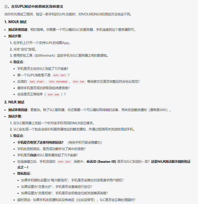
SUPL
SUPL === Secure User Plane Location === 安全用户面定位
SUPL(Secure User Plane Location)是 OMA(Open Mobile Alliance) LOC(Location)工作组指定的基于用户层面的 AGPS 定位技术标准。

SUPL 协议是 AGPS 终端和 AGPS 定位平台之间 Lup 接口的协议,用户传输 GNSS 辅助数据和
位置信息。
SUPL 包含位置用户层(Lup:Location User Plane)接口、安全功能(认证和授权)、收费功
能、漫游功能、保密功能等。
SUPL 标准目前有两个版本 SUPL1.0 和 SUPL2.0.
SUPL1.0 版本主要是对立即定位服务进行了定义;
SUPL2.0 增加了周期性触发定位和基于位置时间的触发定位等功能
SET
SET === SUPL Enabled Terminal === (全称为_SUPL终端)
能够与 SUPL 网络进行通讯的 终端设备

SET支持在SUPL中定义的与网络之间通过用户平面承载的交互过程。SET支持以下一种或者多种功能:
o SUPL隐私功能
o SUPL安全功能
o SUPL SET预设功能
SET支持SET-based和/或SET-assisted定位计算。SET还可能支持以下的功能:
o SUPL定位计算功能
o 辅助数据递送功能
SLP平台通过PPG或者SMSC来发送定位请求的消息。


对于代理模式,业务管理和定位确定所需的SUPL应用消息交互发生在SLC和SET间;

对于非代理模式,业务管理所需的信息交互发生在SLC和SET间,而与定位确定相关的信息交互发生在SPC和SET间。
SLP
SLP === SUPL Location Platform == SUPL的业务平台称为SUPL Location Platform,简称SLP SUPL服务管理和位置确定的实体, SLP 包含 SLC_SUPL位置服务中心 和 SPC 功能。
H-SLP
H-SLP === Home - SUPL Location Platform === 目标终端的归属定位平台
当 SET 终端处于漫游状态时 , H-SLP 标识当前发起原始定位请求的 SLP 平台
V-SLP
V-SLP === Visit - SUPL Location Platform === 终端可访问定位平台
当 SET 终端处于漫游状态时 , V-SLP 标识当前 终端能直接访问到的 SLP , 区别于 发起定位愿寺后请求的那个 H-SLP
D-SLP
D-SLP === Discovered-SLP location platform === 发现SUPL定位平台
当 SET 终端处于漫游状态时 ,D-SLP 标识当前能直接与SET 进行SUPL交互的定位 SLP 平台
SLC
SLC === SUPL Location Center == SUPL位置中心
SUPL网络中的实体,用于协调网络中的Supl请求,并通过用户平面 User Plane 来承载 与 SET 进行交互

SLC系统协调网络中的SUPL操作,在和SET通过用户平面承载进行交互时执行下述功能:
o SUPL隐私功能(SPF)
o SUPL发起功能(SIF)
o SUPL安全功能(SSF)
o SUPL漫游支持功能(SRSF)
o SUPL计费功能(SCF)
o SUPL业务管理功能(SSMF)
o SUPL定位计算功能(SPCF)

SLC有可能将位置ID翻译成用经/纬度数据描述的地理位置,
这种较粗的定位方式有可能已能满足SUPL代理所要求的QoP(定位质量要求),
在MNO环境中,这通常被称作Cell-ID定位。
SPC
SLC === SUPL Position Center == SUPL定位中心 SUPL网络中的实体,负责位置计算和援助数据交付所需的所有消息和程序
SPC支持以下功能:
o SUPL安全功能(SSF)
o SUPL辅助数据递送功能(SADF)
o SUPL参考位置取回功能(SRRF)
o SUPL定位计算功能(SPCF)
MLS
MLS === Mobile Location Service === 移动定位服务
SUPL Agent
Service access point which accesses the network resources to obtain location infomation.
访问网络资源以获取位置信息的服务接入点(网络入口)


SUPL Agent  是一个需要获取位置信息的应用程序 ,  可以在SET终端  也可以在 SUPL Network 中


不论哪种情况,定位请求只能由SUPL Agent发起。如果SUPL Agent在SET中,这种请求方式叫SET Initiated请求(终端始发定位请求) SI

如果SUPL Agent位于SUPL Network中,则这种请求方式叫Network Initiated请求(网络始发定位请求)。NI
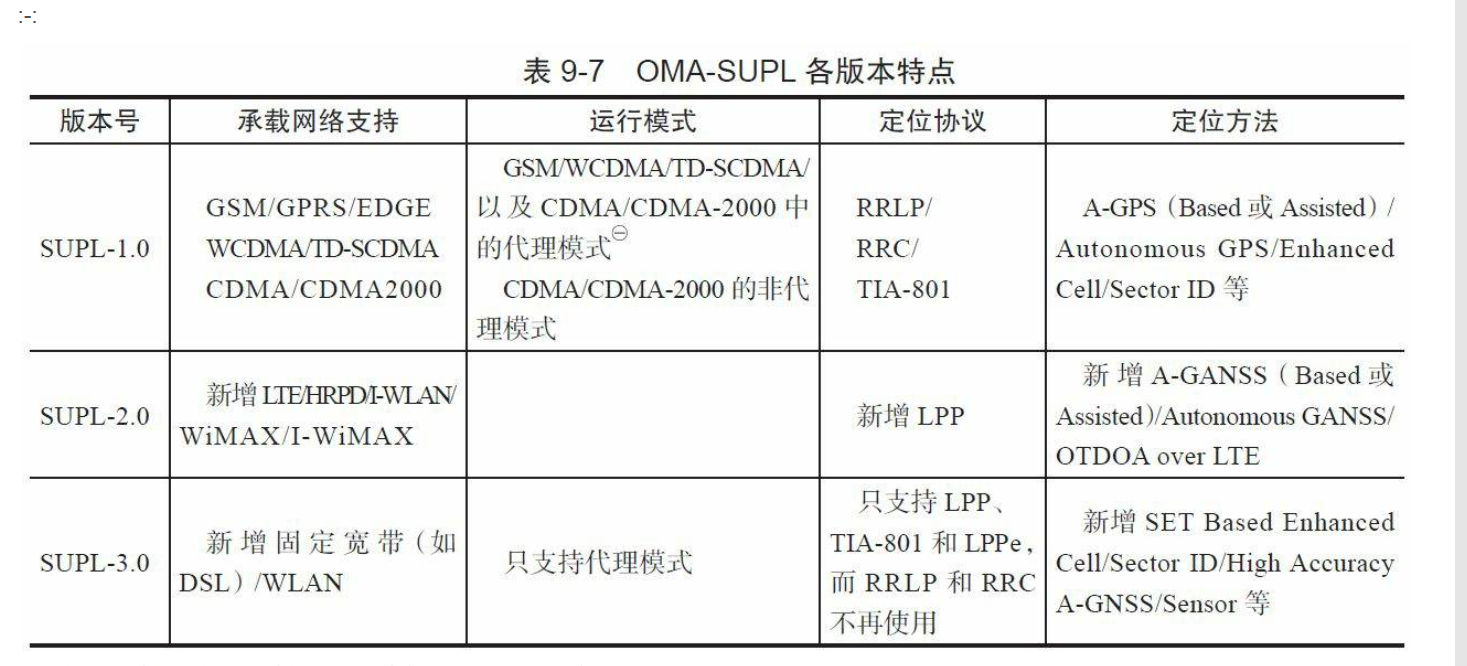
SET Initiated SUPL Service
SET Initiated SUPL Service === SUPL终端初始化服务
该服务是由 SET 发起提交的服务,  SUPL Agent 代理驻留在 SET 中
SET Initiated SUPL Services are services which originate from the SET.
For these services, the SUPL Agent resides within the SET.


SUPL Agent  是一个需要获取位置信息的应用程序 ,  可以在SET终端  也可以在 SUPL Network 中

不论哪种情况,定位请求只能由SUPL Agent发起。如果SUPL Agent在SET中,这种请求方式叫SET Initiated请求(终端始发定位请求) SI

如果SUPL Agent位于SUPL Network中,则这种请求方式叫Network Initiated请求(网络始发定位请求)。NI


SUPL INIT:

对于网络始发定位请求 NI 而言,SLP需要通知目标SET参与定位工作
(而在终端始发定位请求SI中,请求的发起者与SET在一个设备上),这个流程也叫SUPL INIT
Network Initiated SUPL Services
Network Initiated SUPL Services == 网络端初始化服务
由网络端进行初始化的相关SUPL服务

Network Initiated SUPL Services are services which originate
from within the SUPL network asopposed to the SET.
For these services, the SUPL Agent resides in the Network.
Proxy Mode
Proxy Mode === 代理模式
SPC --《--SLC--》-- SET

SPC 系统不会与 SET 直接通信。在此环境中,SLC 系统将充当 SET 和 SPC 之间的代理。

The SPC system will not have direct communication with the SET. In this environment the SLC
system will act as a proxy between the SET and the SPC.
Non-Proxy Mode
Non-Proxy Mode === 非代理模式
SPC --- SLC
 |       |
 |       |
  【SET】

SPC 系统将与 SET 直接通信。
Mode The SPC system will have direct communication with the SET
LAC
LAC === Location Area Code(3GPP) === 位置区号
LCS
Location Services (LCS) === 定位服务
LPP
LPP === LTE Position Protocol === LTE通信定位协议
LPPe
LPPe === LPP Extensions === OMA LPP扩展协议
SUPL 测试机器现场
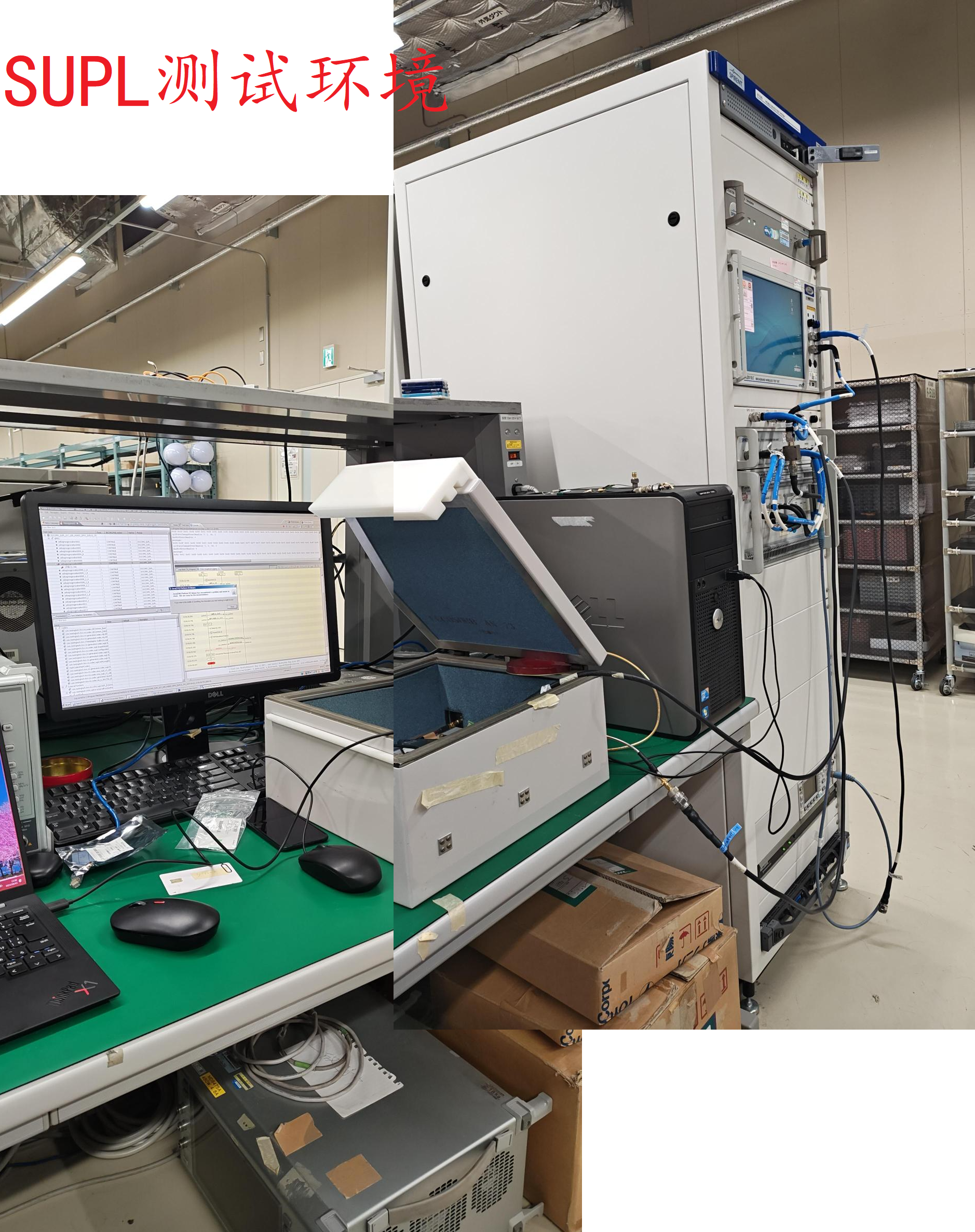
LTE_LPP 信道数据流图
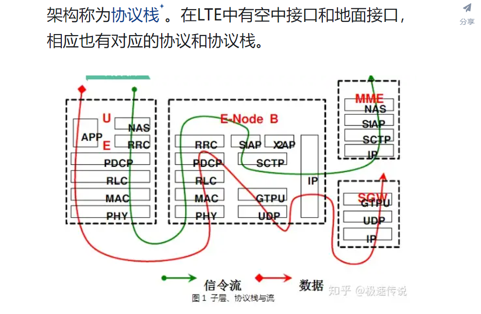
LTE_RR_MM_CM各层
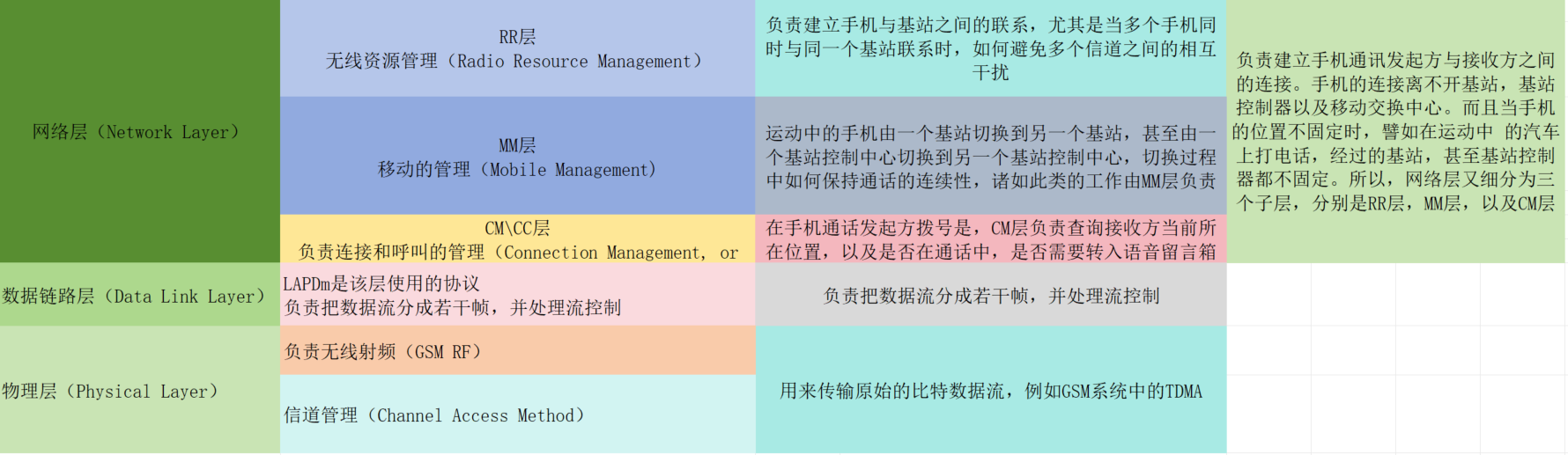
MCC
MCC == Mobile Country Code (3GPP) == 移动国家代码
MNC
MNC == Mobile Network Code (3GPP) == 移动网络代码_在国家码下属
MNL
MNL == Mediatek Navigation Library == MNL 是Mediatek Navigation Library的缩写,版本号是以日期标注的,例如MNL_VER_14051401ALPS05_3.60_09
将设置中的位置服务打开,请进入工程模式下YGPS-----》INFORMATION--àMNL version就可以看到该版本号。
MNLD
MNLD == Mediatek Navigation Library Daemon == MNL 是Mediatek Navigation Library Daemon 的缩写 MTK导航守护daemon进程
MPE
MPE == MEMS-sensor Positioning Engine == 微机电惯性导航定位引擎 MEMS == Micro-Electro-Mechanical System == 基于微机电系统传感器技术的微型惯性导航系统
MPE (Mems-sensor Positioning Engine),俗称惯导系统,利用加速度计(Accelerometer)和陀螺仪(Gyroscope)等惯性传感器,测量载体的加速度和角速度,
通过积分计算出载体的位置、速度和姿态的导航系统。
是一种依靠sensor数据修正载体位置的算法。

UDR:Untethered Dead Reckoning ,主要指【车载场景 UDR】下的惯导算法,测试时需要使用固定硬支架夹紧设备,避免行车过程中出现弹性晃动
PDR:Pedestrian Dead Reckoning ,主要指【行人场景 PDR】下的惯导算法,包括手持、腰包、臂包等方式下的步行、跑步场景,尽量保证设备跟随测试主体规律运动
分析MPE问题需要的讯息:
1.当前项目软/硬件是否支持MPE
2.是否包含虚拟sensor(如虚拟陀螺仪)
3.当前项目使用的sensor型号
4.测试机包含开机log的mobile log、gps debug log(.nma)以及sensor log(se_ut_XXXX)
5.对比机log,如果有RTK,也需要一并提供
6.问题时间段、问题现象


MPE生效的前提:
1.硬件支持:
MTK有建立一份QVL list,罗列出目前通过MTK验证的sensor型号如下,如果厂商选择的sensor型号在QVL list中,默认可以支持:
MPE (MEMS-sensor Positioning Engine) 融合技术,使用微机电传感器(加速器、陀螺仪、磁力计)融合全球卫星导航系统,
广泛运用于驾驶、步行与跑步等智能手机用户日常导航应用场景。

MPE融合技术能够优化卫星信号不佳区域的导航体验,比如在隧道,高架桥下或者都市区高楼大厦等地方,
让用户可以随时随地享受高精度定位带来的优势体验,在更精确的定位下到达目的地或记录运动轨迹。
依托于在GPS方面的技术实力,联发科明确了未来智能手机导航定位技术的发展趋势。
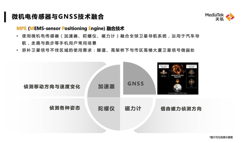
MSID
MSID === Mobile Station Identifier === 移动站标识码
QoP
QoP === Quality of Position === 定位质量
SIP
SIP === Session Initiation Protocol === 会话初始化协议
SIP INVITE
SIP INVITE ===
SIP INVITE是用于在用户代理之间建立媒体会话的请求方法,比如发起一个呼叫.

当用户发送INVITE并收到200 OK响应后【接通电话的意思?】,会发送ACK确认,从而建立会话。

SIP INVITE用于启动会话,并在成功响应后建立对话(dialog)
SIP消息格式:
     INVITE sip:bob@biloxi.com SIP/2.0
     Via: SIP/2.0/UDP pc33.atlanta.com;branch=z9hG4bKnashds8
     From: Alice <sip:alice@atlanta.com>;tag=1928301774
     To: Bob <sip:bob@biloxi.com>
     Call-ID: a84b4c76e66710
     CSeq: 314159 INVITE
     Content-Type: application/sdp
     Content-Length: [长度]

Request-URI: 标识接收方地址  ( 如 sip:bob@biloxi.com )
Via: 记录请求路径,确保响应按原路返回
From/To: 分别表示发起方和接收方身份,tag参数用于区分同一会话的不同事务
Call-ID:  唯一标识会话,需全局唯一
CSeq:  序列号与方法组合  (如314159 INVITE) ,用于事务排序
Contact: 提供直接联系发起方的UR
SMLC
Serving Mobile Location Centre === 移动位置服务中心
V-SLP
V-SLP === Visited SLP
V-SPC
V-SPC === Visited SPC
VTG
VGT === Track Made Good and Ground Speed ===地面速度信息
ULP
ULP === Userplane Location Protocol === 用户面位置协议
UBP
UBP === uncompensated barometric pressure === 无补偿气压技术
LPPe SUPL 中 有对 UBP(无补偿气压技术)的支持  常用于 Z轴定位测试项目


FCC国联邦通信委员会已经针对手机的Z轴定位技术提出了强制性要求。
2019年10月,在第五次报告和命令中明确提出
 对支持Z轴定位的手机,80%的E911无线呼叫采用【正负3米的Z轴精度】度量。


使用无补偿气压(UBP)技术实现Z轴定位测试主要是通过气压控制单元对气压仓进行加压,
将终端放入气压仓内,终端内置的气压计即可检测出当前所处环境的气压值,
终端将测量值上报后与模拟值进行比对,终端上报的气压测量值为无补偿气压值,即对外界温度影响产生的变化不进行修正。
UE
UE === User ELquipment === 用户终端设备
UT1_UT2_UT3
UT1 ---> UE Time1  用户设备时间1   设备UE发送SUPL_START 到得到TE反馈Response的超时时间
UT2 ---> UE Time2  用户设备时间2   设备UE发送SUPL_POS_INIT  到得到TE反馈 SUPL_POS 的超时时间
UT3 ---> UE Time3  用户设备时间3   设备UE发送SUPL_POS  到 TE反馈 SUPL_END的超时时间


PreSUPL UE timer1
ID – 02787
Type – UINT32
Range – 0 to 255 Units – Seconds
Default value – 20  // 默认值时 20秒
INPUT,VALUE,NAME,SIZE,TYPE // 当前读取值10
10,10,aagps_default_presupl_ue_timer1_value,32,Uint32

ID – 02787 Descripton
This NV item is used for SUPL although the name remains PreSUPL UE Timer1 for legacy reasons.
This is the timeout from the UE sending SUPL_START to its receipt of SUPL_RESPONSE from the SLP.
The same value is also used for the timer used to wait for the initial datalink to be established.


PreSUPL UE timer2
ID – 02788
Type – UINT32
Range – 0 to 255 Units – Seconds
Default value – 20            // 默认值20
INPUT,VALUE,NAME,SIZE,TYPE   // 当前读取值10
10,10,aagps_default_presupl_ue_timer2_value,32,Uint32

ID – 02788 Descripton
This NV item is used for SUPL although the name remains PreSUPL UE Timer2 for legacy reasons.
This is the timeout from the UE sending SUPL_POS_INIT to its receipt of the first SUPL_POS from the SLP.


PreSUPL UE timer3
ID – 02789
Type – UINT32
Range – 0 to 255 Units – Seconds
Default value – 20   // 默认值20
INPUT,VALUE,NAME,SIZE,TYPE  // 当前读取值10
10,10,aagps_default_presupl_ue_timer3_value,32,Uint32

ID – 02789  Descripton:
This NV item is used for SUPL although the name remains PreSUPL UE Timer3 for legacy reasons.
This is the timeout from the UE sending SUPL_POS to its receipt of SUPL_END from the SLP,
or any subsequent SUPL_POS from the SLP.
UP_UserPlane
UserPlane == UP == 用户面(数据面)
通信系统中,一般存在 UserPlane_UP用户面 和 ControlPlane CP控制面之分。

UserPlane_UP用户面 传输真正的业务数据,比如语音数据 分组业务数据。
ControlPlane CP控制面 用来传输信令的 , 用来控制一个呼叫流程建立,维护 以及释放 。

UP用户面如同负责搬运的码头工人,CP控制面就相当于指挥员,
当两个层面不分离时,自己既要负责搬运又要负责指挥,这种情况不利于大货物处理,
因此分工独立后,办事效率可成倍提升,在LTE网络中,用户面和控制面已明确分离开


实际应用中的SUPL系统架构,SLP(Secure Location Platform) 安全定位平台与 终端手机(SET) 可能不在一个分域中,
SLP无法获取 SET的IP地址 导致无法建立 基于 UP 的 TCP连接 , 所以 SLP 需要通过 WAP PUSh消息( 短信消息 ) 的方式通知 SET 来建立 SUPL连接。


Cp --- E-911


        |--- MSA (网络为主_紧急呼叫)
(SUPL)UP|
        |--- MSB (终端为主 提高TTFF)
CP_ControlPlane
ControlPlane == CP == 控制面(管理面)
通信系统中,一般存在 UserPlane_UP用户面 和 ControlPlane CP控制面之分。

UserPlane_UP用户面 传输真正的业务数据,比如语音数据 分组业务数据。
ControlPlane CP控制面 用来传输信令的 , 用来控制一个呼叫流程建立,维护 以及释放 。

UP用户面如同负责搬运的码头工人,CP控制面就相当于指挥员,
当两个层面不分离时,自己既要负责搬运又要负责指挥,这种情况不利于大货物处理,
因此分工独立后,办事效率可成倍提升,在LTE网络中,用户面和控制面已明确分离开


1.E-911 紧急呼叫就是基于 CP控制面的来实现AGPS定位的方式


Cp --- E-911


        |--- MSA (网络为主_紧急呼叫)
(SUPL)UP|
        |--- MSB (终端为主 提高TTFF)
OTDOA
OTDOA === Observed Time Difference of Arrival === 到达时间差定位法
OTDOA(Observed Time Difference of Arrival)是一种应用于3G网络的定位方式。
这种定位技术通过移动终端测量不同 基站的下行导频信号的到达时刻(TOA,Time of Arrival)实现定位,
其定位精度较高,定位范围约为100~200m。但对时间基准的依赖性较强,同时受多径干扰的影响也较大。
OTDOA定位响应时间比CELL-ID略长,大约要10s。
该技术无需对手机进行修改而只需修改网络,即可直接向现有用户提供服务。
TBS
TBS === Terrestrial Beacon System === 大陆信标信息
TOA_Time Of Arrive
TOA === Time Of Arrive === 到达时间测距
GNSS 是用来 利用 TOA 测距原理来完成 确定 设备位置的 。
这一原理需要测量 信号从位置已知的发射源( 卫星 ) 发出到 用户接收机经历的时间。
这个 时间间隔 称之为 信号传播时间 , 将时间 乘以 传播速度( 电磁信号_光速 ) 便得到发射源与接收源的距离。

接收源(用户接收机) 从多个(最低三个)发射源得到了 信号传播时间, 就能以此计算出当前 接收机的位置。
PDN
PDN === Packet Data Network === 分组数据网络
在移动通信中,PDN连接是用户设备(UE)连接到外部数据网络的通道
PVT
PVT === Position && Velocity && Time === 位置 && 速度 && 时间
L频段
大多数 GNSS 全球导航系统使用
L 频段 (1-2 GHz)
【1164_MHz】---【1300_MHz】 和
【1559_MHz】---【1610_MHz】 频段的载波 对外提供 导航信号
L波段是指频率在1-2 GHz的无线电波波段,L波段可被用于DAB、卫星导航系统等。


S频段 (2-4 GHz)
S波段(英语:S band)是指频率在2-4 GHz的无线电波波段。
NASA和欧洲空间局的深空站通用的S波段通信频率范围为上行2025-2120 MHz,下行2200-2300 MHz


C频段 (4-8 GHz)
C波段是指频率在4-8 GHz的无线电波波段。通常的上行频率范围为5.925-6.425 GHz,下行频率则为3.7-4.2 GHz,
即上下行带宽各为500 MHz[1]。早期卫星通信使用的是C波段,后来因为C波段变得拥挤,于是就相继出现了Ku波段、Ka波段等
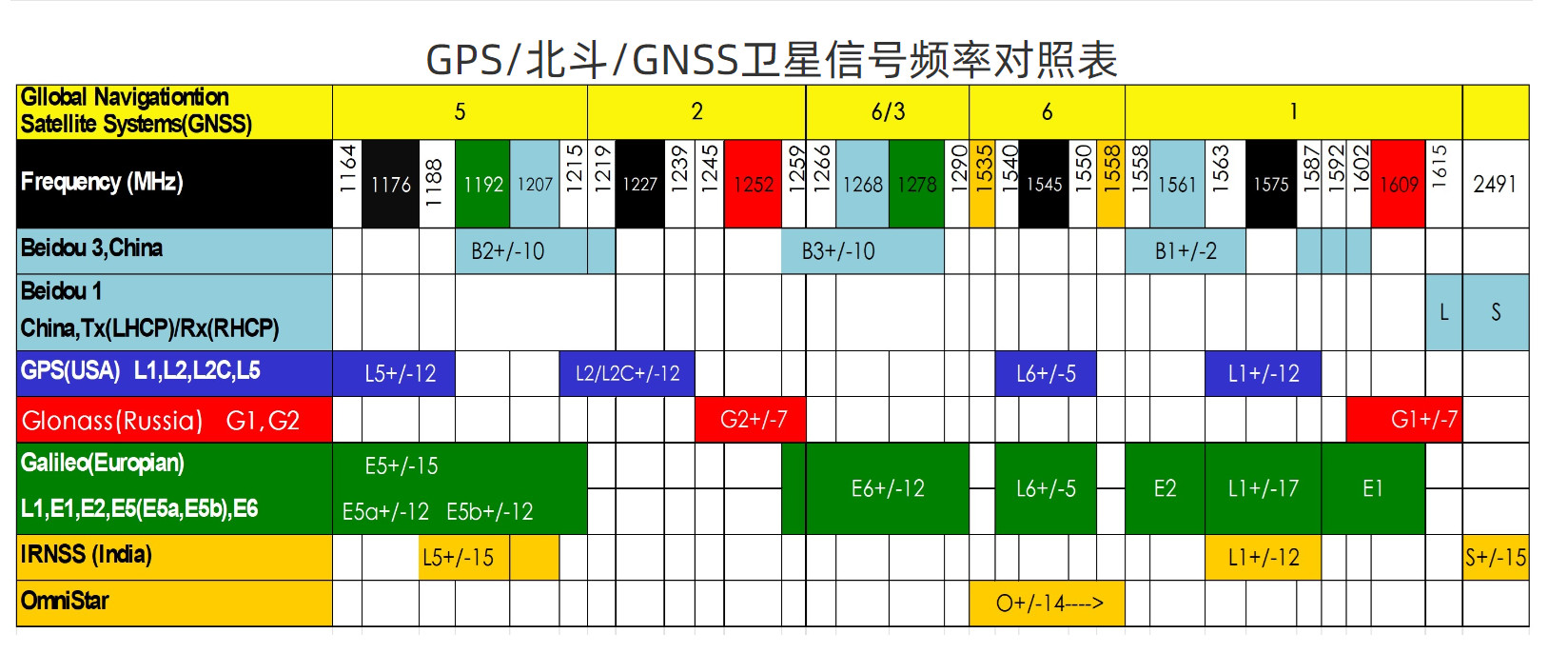
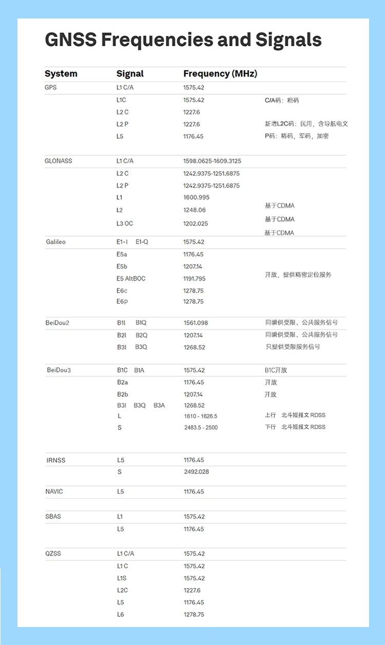
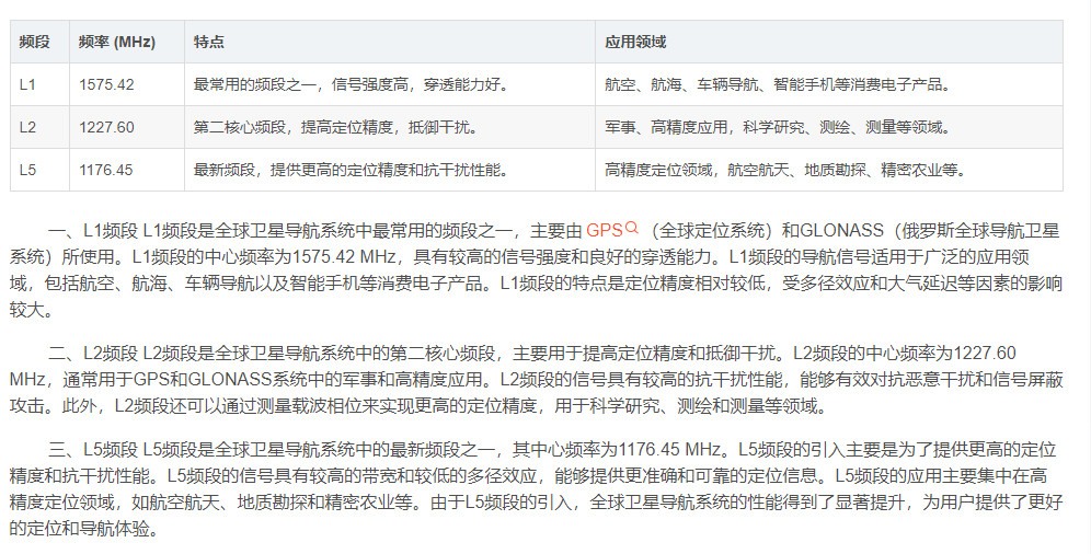

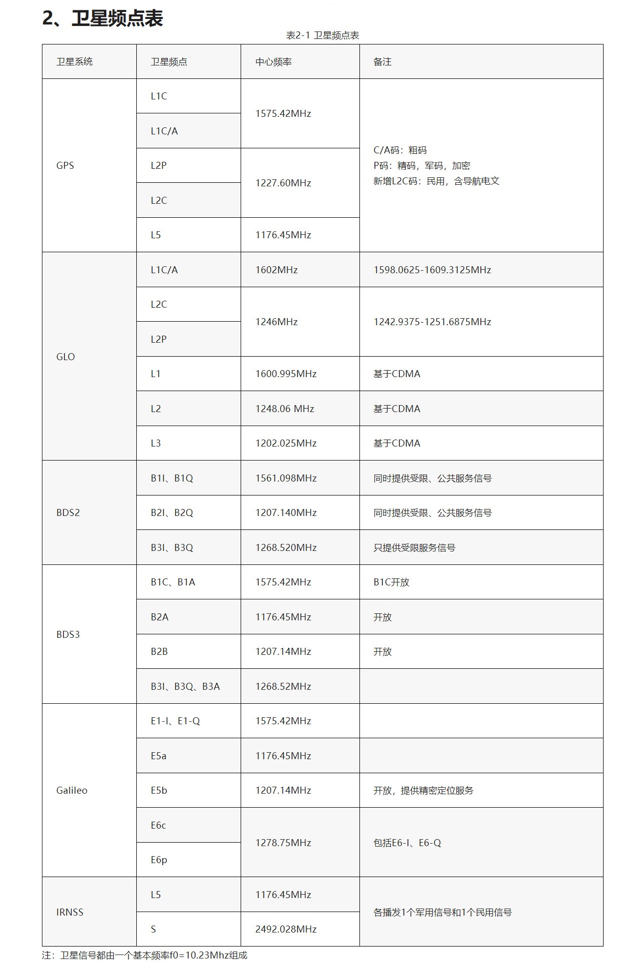
北斗导航频段
北斗卫星导航系统的官方宣布,在L波段和S波段发送导航信号,
在【L波段】的【B1、B2、B3频点】上发送服务信号,包括开放的信号和需要授权的信号。[34]

B1频点:1559.052MHz-1591.788MHz
B2频点:1166.220MHz-1217.370MHz
B3频点:1250.618MHz-1286.423MHz
PRN
PRN === pseudo random noise code === 伪随机噪声编码
GNSS系统中 SV卫星发射 PRN 伪随机噪声编码信号 以便进行伪距测量
这个概念使得GNSS 对用户来说是一个被动系统,即只由系统发射信号 用户被动接收这些信号,因此才能达到无数用户同时使用GPS。

伪随机噪声码(Pseudo Random Noise,简称 PRN) 一种测距码

在GPS中用的C/A码是一个群集,它们通常又被叫做伪随机噪声(Pseudorandom Noise,PRN)序列,
因为它们有着噪声的部分性质,GPS的C/A码里有着1023个元素,这里面含有512个1与511个0,他们的排列是看起来仿佛随机的,
但是却是完全可决定的,因此叫做伪随机噪声序列。
AODO
AODO === Age of Data Offset === 广播星历参数和资料龄期
AODO === Age of Data Offset  === 广播星历参数和资料龄期


导航电文是具有一定格式的二进制码,以“帧”为单位向用户发送。
每帧电文含有1500bit,传输速率为50bit/s。每个主帧包含5个子帧:


子帧1包含有卫星钟改正数、GPS周数(Week Number)和卫星工作状态讯息

子帧2和子帧3主要向用户提供有关计算卫星在轨位置的讯息,包括广播星历参数和资料龄期(Age of Data Offset,简称AODO)

子帧4和子帧5提供了卫星导航、星座历书等讯息
ECID
ECID === Enhanced Cell ID === 增强区位id
EOTD
EOTD === Enhanced Observed Time Difference === 增强 到达时间测距
EPO
EPO === (Extended Prediction Orbit) === 联发科的A-GPS解决方案之一
EPO是联发科的A-GPS解决方案之一。
通过预测技术,将未来一段时间内的预测卫星星历数据放到MTK服务器,可以作为MTK GPS芯片AGPS定位的一种辅助星历数据。
QEPO
QEPO === Quarter of one day’s EPO
和EPO类似,但是时效性比EPO短,精度比EPO高
星历_历书
星历 是 GPS 卫星轨道的 准开普勒表示 , 参数正常时每天从地面站更新到卫星上传一次,有效期为【3】到【4】小时。


历书 是降低精度的 星历 参数的一个子集 , 历书数据可以用来预测卫星的大概位置, 辅助捕获卫星信号。
NI
NI === NetWork Initiate === 网络端发起
基于SUPL协议的手机移动定位系统优化设计与实现-软件工程专业论文.docx https://max.book118.com/html/2018/1218/6133240003001240.shtm
NI:  如果SUPL Agent位于SUPL Network中,则这种请求方式叫Network Initiated请求(网络始发定位请求)。NI
NI 是指 SLP(SecureUserPlane Location Platform) 平台收到平台Host进程请求, 主动对 SET终端建立连接并进行SUPL定位 ,并将SET的位置反馈给 平台Host进程的过程。


SUPL Agent  是一个需要获取位置信息的应用程序 ,  可以在SET终端  也可以在 SUPL Network 中


不论哪种情况,定位请求只能由SUPL Agent发起。

SI:  如果SUPL Agent在SET中,这种请求方式叫SET Initiated请求(终端始发定位请求) SI

NI:  如果SUPL Agent位于SUPL Network中,则这种请求方式叫Network Initiated请求(网络始发定位请求)。NI
NI 是指 SLP(SecureUserPlane Location Platform) 平台收到平台Host进程请求, 主动对 SET终端建立连接并进行SUPL定位 ,并将SET的位置反馈给 平台Host进程的过程。


NI SLP平台端发起的SUPL过程
1. 平台Host进程 发送定位请求(Location REQ消息)给到 SLP(定位平台)
2. SLP平台 收到消息 使用 短消息 SMS 向指定的 SET( Location REQ包含SET) 发送 SUPL初始化请求。


           【 SUPL START 】 NW -> MS════1════
        【 SUPL Response 】 MS -> NW════2════
          【SUPL POS Init】 NW -> MS════3短信════
═════4.0══════【SUPL POS 】 MS -> NW
═════4.1══════【SUPL POS 】 NW -> MS
             【SUPL END1 】 MS -> NW
             【SUPL END2 】 NW -> Host══6════    向 Host请求客户端反馈 SET的位置信息
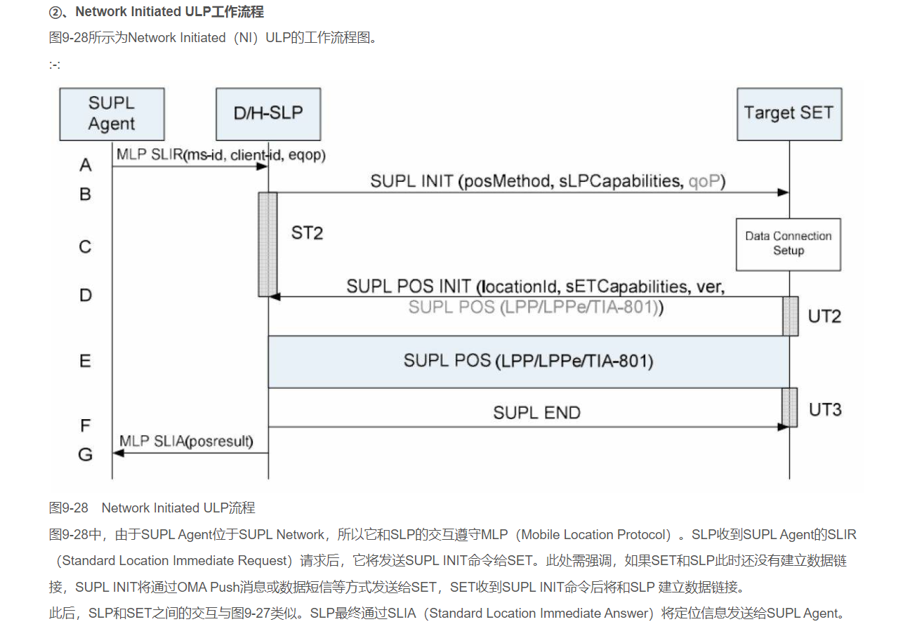
NI_no_roaming 执行流程
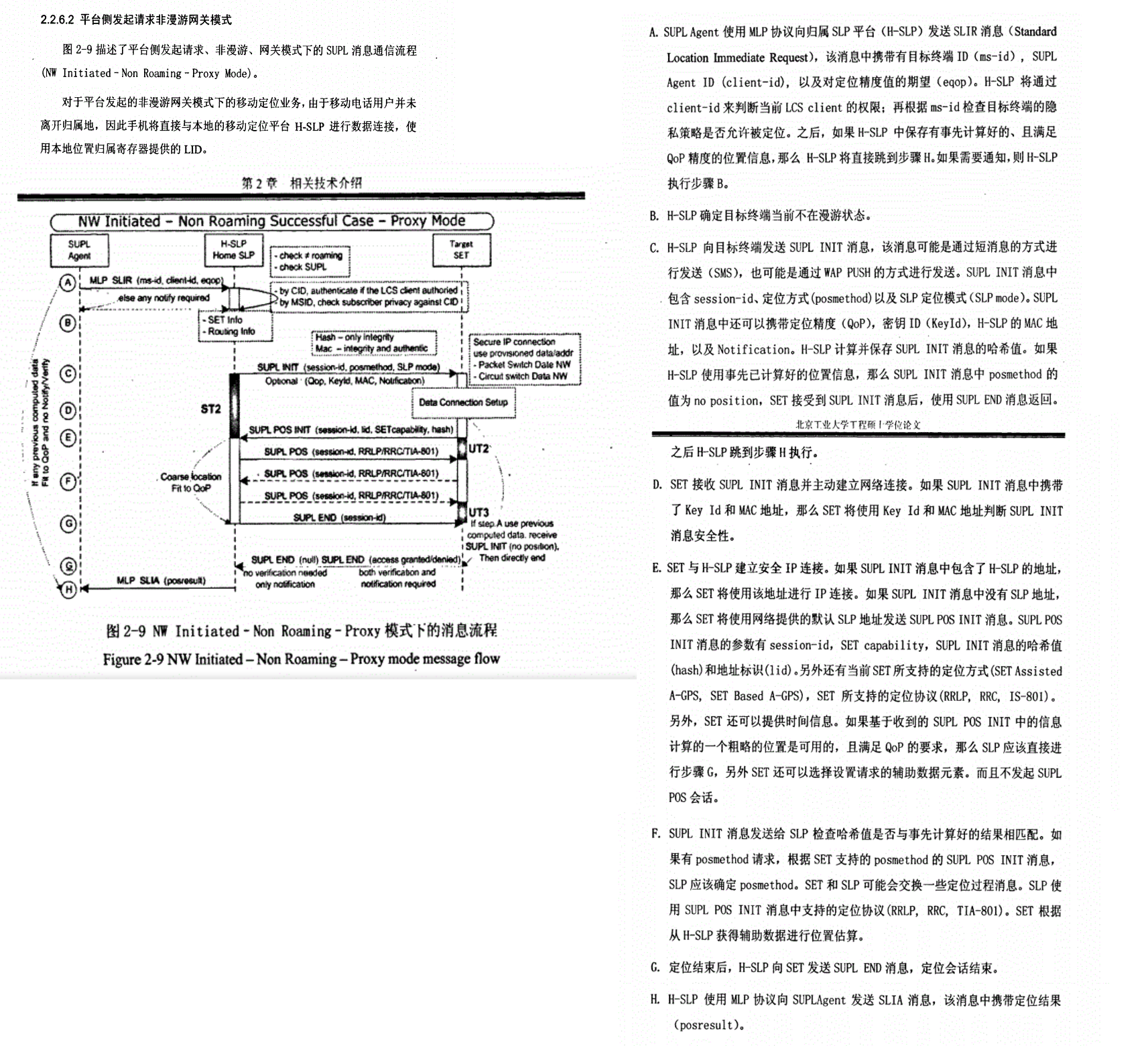
NI_roaming 执行流程
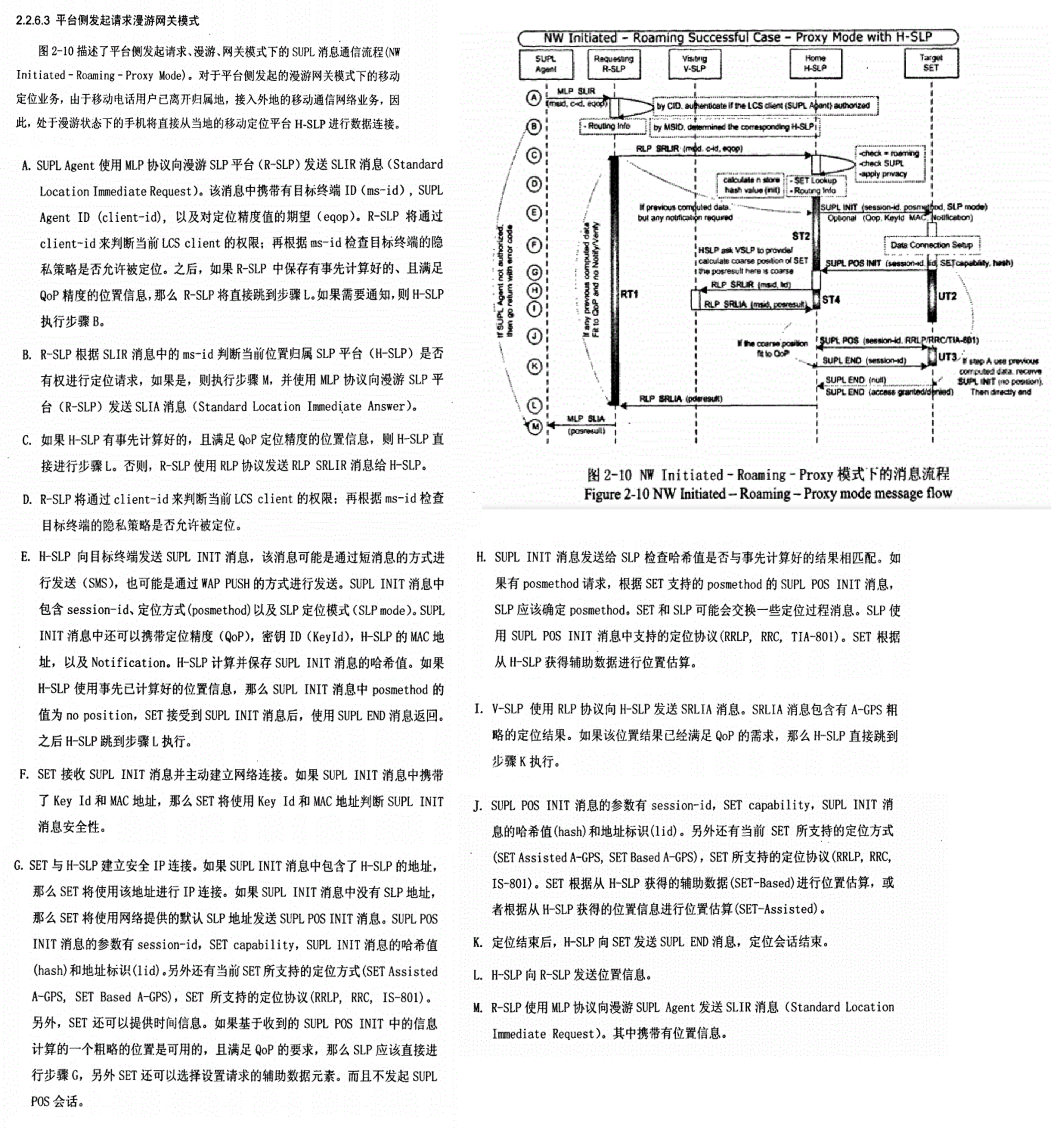
SI
SI === Set Initiate === 设备端发起
SI_________SET Initiated      ===== MOLR
NI_________Network Initiated  ===== NILR


在SUPL的术语体系中,SET Initiated 和 Network Initiated 与 MOLR 和 NILR 是一一对应的关系,只是描述角度不同。

SET Initiated = MOLR (Mobile Originated Location Request)   两者都强调定位请求是由移动终端(手机)发起的。

Network Initiated = NILR (Network Initiated Location Request) 两者都强调定位请求是由网络侧发起的。


SUPL Agent  是一个需要获取位置信息的应用程序 ,  可以在SET终端  也可以在 SUPL Network 中


不论哪种情况,定位请求只能由SUPL Agent发起。

SI:  如果SUPL Agent在SET中,这种请求方式叫SET Initiated请求(终端始发定位请求) SI

NI:  如果SUPL Agent位于SUPL Network中,则这种请求方式叫Network Initiated请求(网络始发定位请求)。NI


SUPL INIT:

对于网络始发定位请求 NI 而言,SLP需要通知目标SET参与定位工作
(而在终端始发定位请求SI中,请求的发起者与SET在一个设备上),这个流程也叫SUPL INIT


SI 终端发起的SUPL过程
1. SET手机终端 向 SLP( SecureUserPlane Location Platfrom ) 安全用户面定位平台 发送    【 SUPL START 】 MS -> NW════1════
2. SLP 反馈  SUPL Response 消息给 SET  以回应 SUPL Start 消息                      【 SUPL Response 】 NW -> MS════2════
3. SET 继续发送 SUPL POS INIT 消息 给到 SLP 平台                                     【SUPL POS Init】 MS -> NW════3════
4.0 SET 与 SLP 进行一系列的 SUPL POS 的交互                                ═════4.0══════【SUPL POS 】 NW -> MS  【协商使用 MSA MSB】
4.1                                                                        ═════4.1══════【SUPL POS 】 MS -> NW
4.2                                                                        ═════4.2══════【SUPL POS 】 NW -> MS
4.3                                                                        ═════4.3══════【SUPL POS 】 MS -> NW
5. 最终 SLP平台 将运算出的位置 通过 SUPL END 发送给SET终端                               【SUPL END 】 NW -> MS════5════
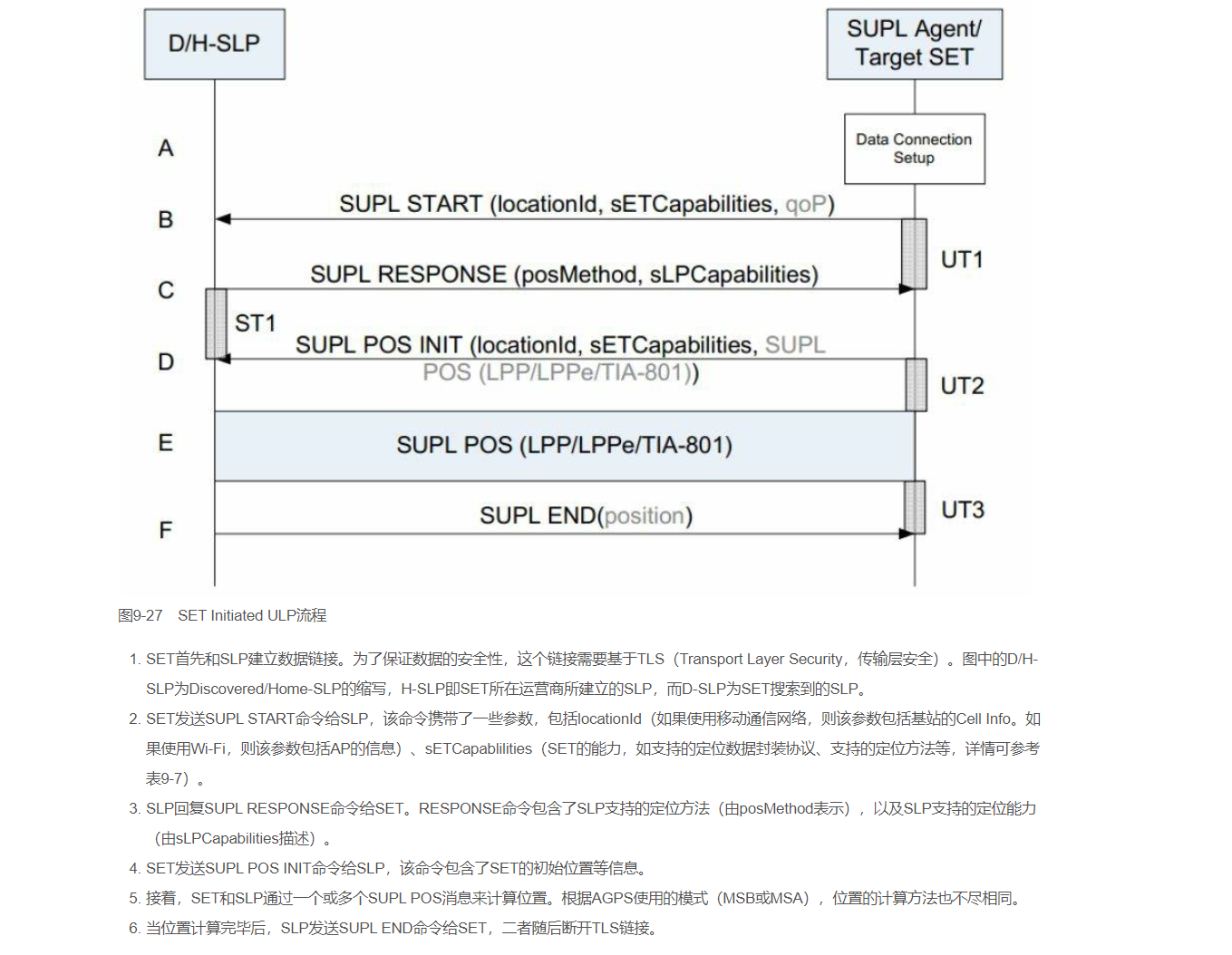
SUPL INIT:

对于网络始发定位请求 NI 而言,SLP需要通知目标SET参与定位工作
(而在终端始发定位请求SI中,请求的发起者与SET在一个设备上),这个流程也叫SUPL INIT


/*
SUPL INIT流程可由一条特殊的数据短信(Data Message)触发。注意,数据短信和我们接触最多的
文本短信(Text Message)不同。下面这个IntentFilter将接收发往127.0.0.1:7275的数据短信。
7275为OMA-SUPL使用的端口号,关于OMA-SUPL端口号见可参考资料[28]。
关于Android中数据短信的收发,见参考资料[33]。
*/
SI_no_roaming 终端SI发起非漫游执行流程
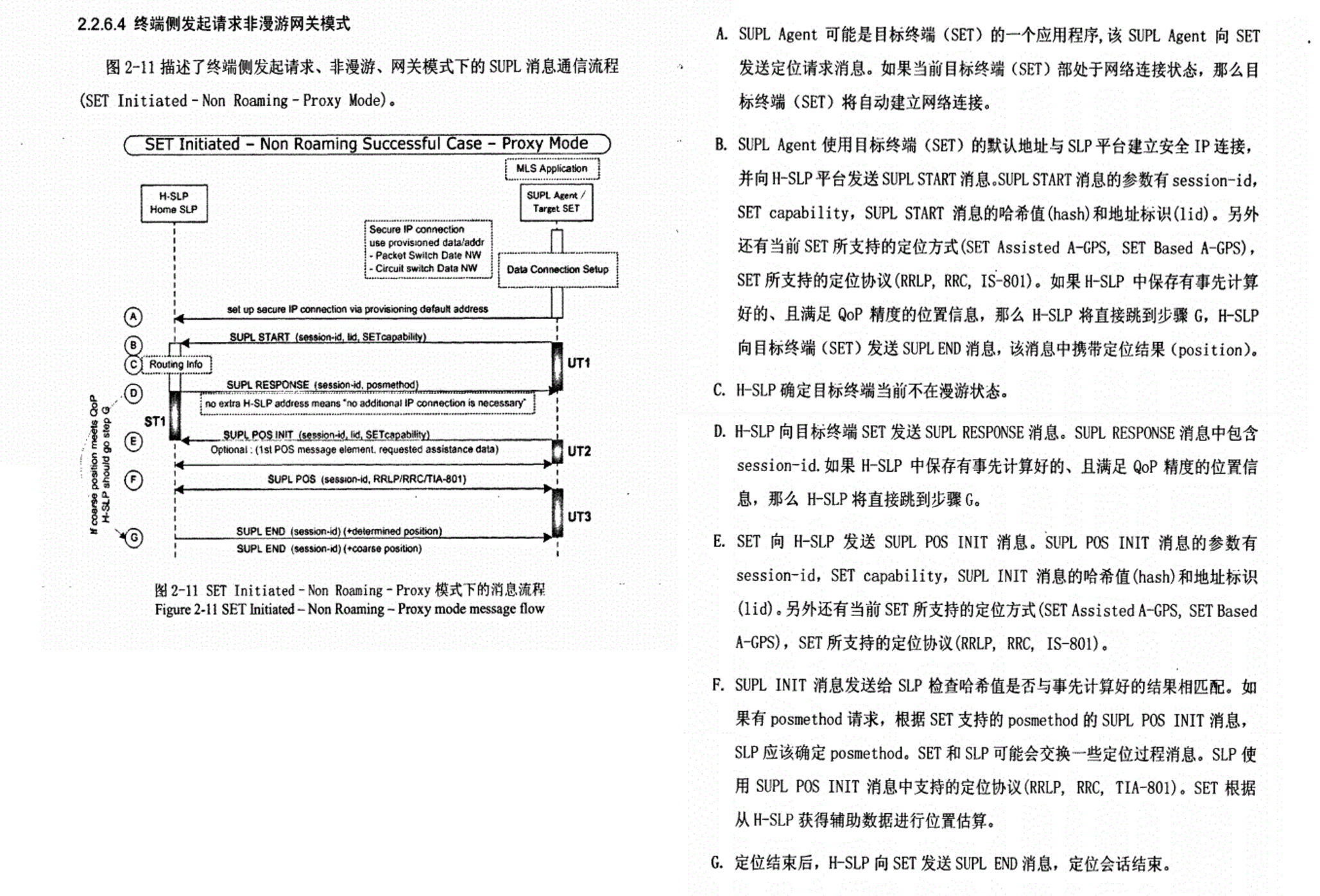
SI_roaming 终端SI发起漫游执行流程
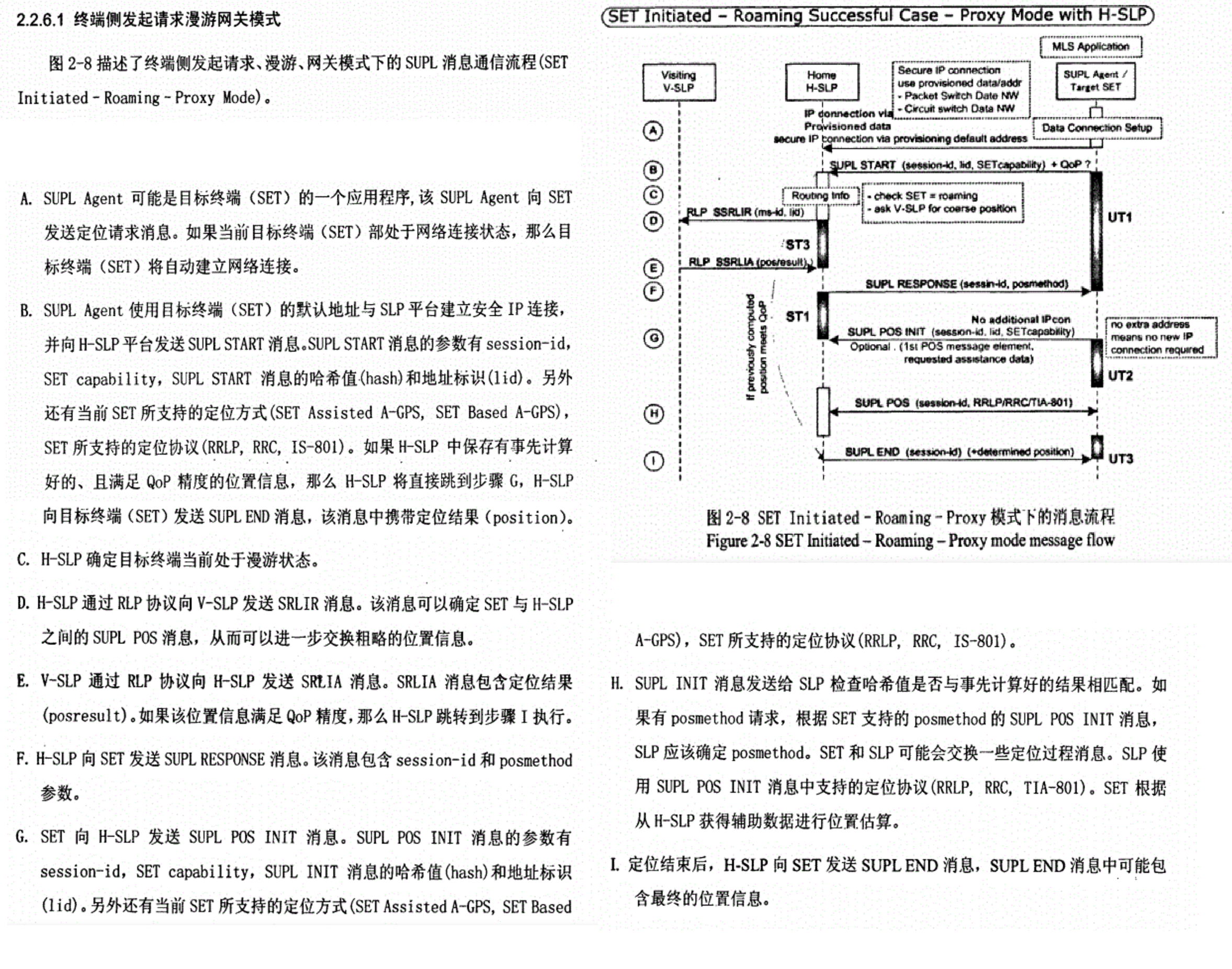
SI_NI的区别
SI_________SET Initiated      ===== MOLR
NI_________Network Initiated  ===== NILR


在SUPL的术语体系中,SET Initiated 和 Network Initiated 与 MOLR 和 NILR 是一一对应的关系,只是描述角度不同。

SET Initiated = MOLR (Mobile Originated Location Request)   两者都强调定位请求是由移动终端(手机)发起的。

Network Initiated = NILR (Network Initiated Location Request) 两者都强调定位请求是由网络侧发起的。


SET Initiated 和 Network Initiated 是对SUPL定位会话发起方式的最高层级划分。它们之间的区别决定了整个定位流程的走向。

一、核心定义(一句话总结)
SET Initiated (终端发起)    : 手机(SET)主动发起的定位请求。可以理解为手机问:“我在哪里?”
Network Initiated (网络发起): 网络侧(SLC)主动发起的定位请求。可以理解为网络问:“手机在哪里?”
这个【“谁主动”】的根本区别,是理解SUPL所有流程的关键。
| 特性 | SET Initiated (终端发起) | Network Initiated (网络发起) |
|---|---|---|
| 发起方 | SET (SUPL Enabled Terminal),即手机终端。 | SLC (SUPL Location Center),即网络中的SUPL定位中心。 |
| 触发源 | 手机上的应用(如地图、导航、外卖App),或用户手动触发。 | 外部应用(如紧急呼叫中心、物流管理平台),或网络自身需要。 |
| 会话流程 | 1. SET 主动向 SLC 建立数据连接(TCP/TLS)。 2. SET 发送 SUPL INIT 消息,开始定位会话。3. 后续进行定位能力协商、位置计算等。 |
1. SLC 需要先“唤醒”或“通知”SET。 2. SLC 通常通过 SMS (短信) 或 USSD 向SET发送一个触发通知,其中包含SLC的地址和会话ID。 3. SET 收到通知后,解析内容,然后主动向SLC建立数据连接。 4. SET 在连接建立后发送 SUPL INIT 消息,并携带从通知中获取的会话ID。 |
| 关键SUPL消息 | SUPL INIT 由 SET 首先发出,开启会话。 |
SUPL INIT 也由 SET 发出,但前提是SET先收到了来自网络的触发通知。 |
| 隐私问题 | 隐私问题相对简单,因为是用户主动行为。 | 隐私问题是核心! 必须确保手机在定位前,根据用户的隐私设置,进行提示或授权。 |
| 典型应用场景 | - 手机地图导航 - 打车软件定位 - 社交App“签到” - 查找附近餐厅 |
- 紧急呼叫 (E911/E112):呼叫中心自动获取用户位置。 - 资产追踪:物流公司追踪车辆位置。 - 家长监控:父母定位孩子的手机。 - 付费服务:基于位置的精准广告推送。 |
| 流程复杂度 | 相对简单,直接建立连接即可。 | 相对复杂,多了一个“触发通知”的环节,对手机的短信/信令处理能力有要求。 |
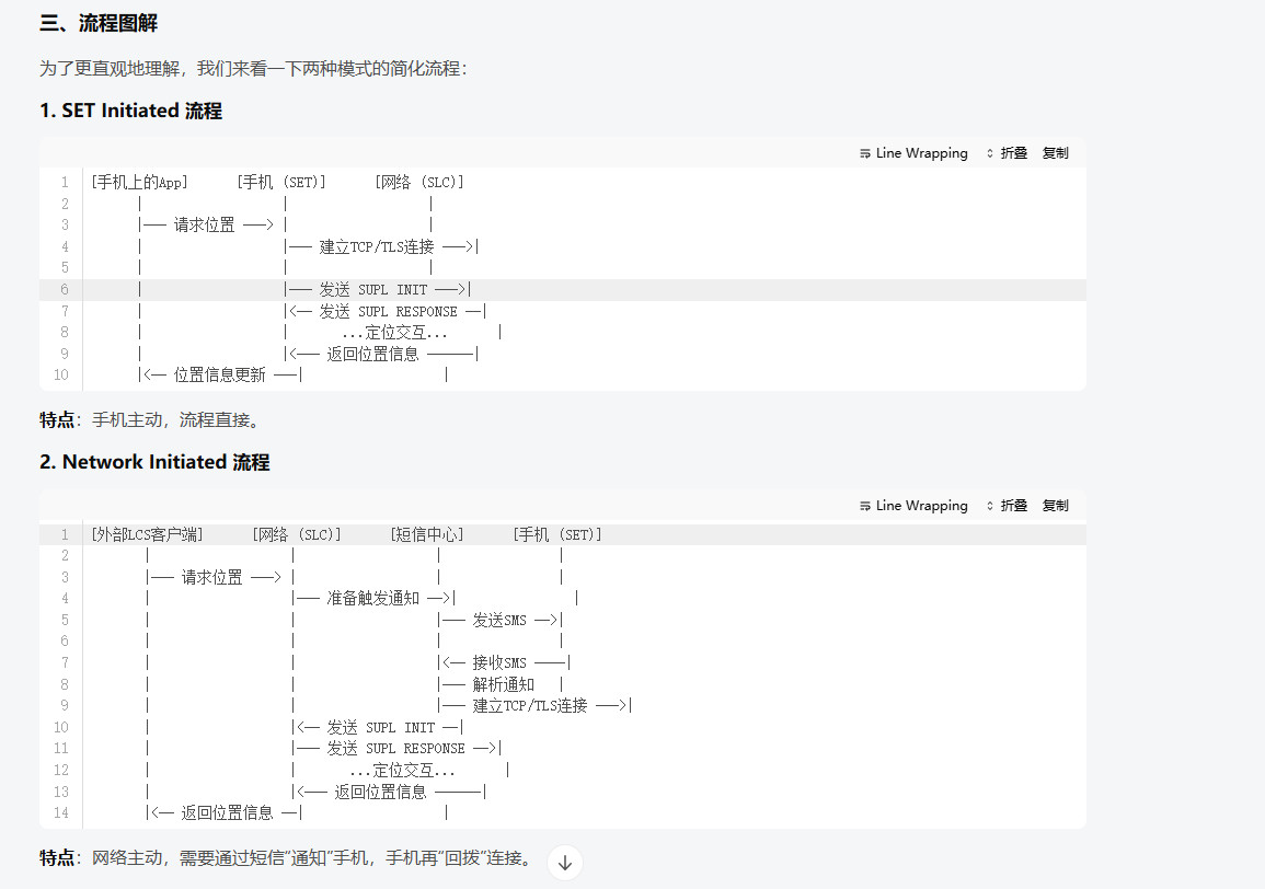
- 流程图解___ SET Initiated 流程 __ 特点:手机主动,流程直接。
[手机上的App] [手机 (SET)] [网络 (SLC)] | | | |— 请求位置 —> | | | |— 建立TCP/TLS连接 —>| | | | | |— 发送 SUPL INIT —>| | |<– 发送 SUPL RESPONSE –| | | …定位交互… | | |<— 返回位置信息 ——| |<– 位置信息更新 —| |
- 流程图解___ Network Initiated 流程___ 特点:网络主动,需要通过短信“通知”手机,手机再“回拨”连接。
[外部LCS客户端] [网络 (SLC)] [短信中心] [手机 (SET)] | | | | |— 请求位置 —> | | | | |— 准备触发通知 –>| | | | |— 发送SMS –>| | | | | | | |<– 接收SMS —-| | | |— 解析通知 | | | |— 建立TCP/TLS连接 —>| | |<– 发送 SUPL INIT –| | |— 发送 SUPL RESPONSE –>| | | …定位交互… | | |<— 返回位置信息 ——| |<– 返回位置信息 –| |
| SET Initiated (MOLR) | Network Initiated (NILR) | |
|---|---|---|
| 本质 | 手机主动问“我在哪?” | 网络主动问“你在哪?” |
| 流程起点 | 手机App | 网络SLC |
| 关键步骤 | 手机直接连接SLC | SLC先发通知,手机再连接SLC |
| 核心关注点 | 定位功能的实现 | 定位功能的实现 + 隐私保护 |
SAP
SAP === Sensor Assisted Position === 传感器辅助定位
Qcom 项目上  8450以上才支持 SAP 功能


SAP辅助定位(Sensor Assisted Positioning)是一种通过传感器(如陀螺仪、加速度计和地磁传感器)改善GPS信号的技术。
这种技术特别适用于城市环境中GPS信号较弱的情况


SAP辅助定位通过结合GNSS信号和传感器数据来实现更精确的定位。
例如,通过GNSS接收器获取卫星信号,同时利用传感器(如IMU、加速度计、陀螺仪等)提供的运动数据,对初始位置进行微调和校准
Wiper
GPS Wiper === GPS wifi positioning
adb pull  /vendor/etc/gps.conf

在 Qcom  gps.conf 有开关

Wiper (wifi positioning), 1=enable, 0=disable(默认)
ENABLE_WIPER=0
C/A码
C/A码(Coarse/Acquisition Code)是用于进行粗略测距和捕获P码的粗码,也称捕获码。
周期为1毫秒
一个周期含有码元即码长为1023
每个码元持续的时间即码元周期 1ms/1023=0.977517微秒
相应的码元宽度为293.05米
C/A码是一种公开的明码,可供全球用户免费使用。但C/A码一般只调制在L1载波上,所以无法精确地消除电离层延迟。
测距精度一般为±(2~3),开放给民间使用的GPS卫星传送标准定位信号,
它包含有GPS接收机用来确定其定位与时间方面的讯息,精确度在100米左右.
/vendor/etc/gps.conf(Qcom)
/*
GPS配置文件,PROPERTIES_FILE的位置为“/etc/gps.conf”。
笔者的Galaxy Note中,该文件的内容如下所示,其中“#”后的内容为笔者添加的注释。
NTP_SERVER=north-america.pool.ntp.org #指定NTP_SERVER
#下面这几个参数指定AGPS LTO(Long Term Orbits)数据的下载地址。LTO存储了GPS卫星
#的星历数据。从下面这些地址中的“4day”来看,这些数据的有效期为4天。AGPS使用时需要
#先从服务器上下载一些辅助数据。如果周围没有网络的情况下该怎么办呢? LTO就好比离线地图,
#当周围没有网络时,终端可以利用事先保存的LTO数据来初始化GPS的定位。当然,LTO有时
#效限制,一般是4天。
XTRA_SERVER_1=http://gllto.glpals.com/4day/glo/v2/latest/lto2.dat
XTRA_SERVER_2=http://gllto.glpals.com/4day/glo/v2/latest/lto2.dat
XTRA_SERVER_3=http://gllto.glpals.com/4day/glo/v2/latest/lto2.dat
SUPL_HOST=supl.google.com #指定SUPL的主机和端口
SUPL_PORT=7276
关于LTO,见参考资料[32]。
*/
adb pull /vendor/etc/gps.conf
adb push ./gps.conf  /vendor/etc/gps.conf


# Error Estimate
# _SET = 1
# _CLEAR = 0
ERR_ESTIMATE=0

#NTP server
NTP_SERVER=time.xtracloud.net

#XTRA CA path
XTRA_CA_PATH=/usr/lib/ssl-1.1/certs

# DEBUG LEVELS: 0 - none, 1 - Error, 2 - Warning, 3 - Info
#               4 - Debug, 5 - Verbose
# If DEBUG_LEVEL is commented, Android's logging levels will be used
DEBUG_LEVEL = 5

# Intermediate position report, 1=enable, 0=disable
INTERMEDIATE_POS=0

# supl version 1.0
SUPL_VER=0x10000

# Emergency SUPL, 1=enable, 0=disable
#SUPL_ES=1

#Choose PDN for Emergency SUPL
#1 - Use emergency PDN
#0 - Use regular SUPL PDN for Emergency SUPL
#USE_EMERGENCY_PDN_FOR_EMERGENCY_SUPL=0

#SUPL_MODE is a bit mask set in config.xml per carrier by default.
#If it is uncommented here, this value will overwrite the value from
#config.xml.
#MSA=0X2
#MSB=0X1
#SUPL_MODE=

# GPS Capabilities bit mask
# SCHEDULING = 0x01
# MSB = 0x02
# MSA = 0x04
# ON_DEMAND_TIME = 0x10
# default = ON_DEMAND_TIME | MSA | MSB | SCHEDULING
CAPABILITIES=0x17

# Accuracy threshold for intermediate positions
# less accurate positions are ignored, 0 for passing all positions
# ACCURACY_THRES=5000

################################
##### AGPS server settings #####
################################

# FOR SUPL SUPPORT, set the following
# SUPL_HOST=supl.host.com or IP
# SUPL_PORT=1234


# FOR C2K PDE SUPPORT, set the following
# C2K_HOST=c2k.pde.com or IP
# C2K_PORT=1234

# Bitmask of slots that are available
# for write/install to, where 1s indicate writable,
# and the default value is 0 where no slots
# are writable. For example, AGPS_CERT_WRITABLE_MASK
# of b1000001010 makes 3 slots available
# and the remaining 7 slots unwritable.
#AGPS_CERT_WRITABLE_MASK=0

####################################
#  LTE Positioning Profile Settings
####################################
# LPP_PROFILE is a bit mask(unit8 in HAL interface)
# 0: Enable RRLP on LTE(Default)
# 0x01: LPP User Plane
# 0x02: LPP Control Plane
# 0x04: LPP User Plane for NR5G
# 0x08: LPP Control Plane for NR5G
# Mot modification
# 0x10: LPPe CP DBH
# 0x20: LPPe CP WLAN
# 0x40: LPPe UP DBH
# 0x80: LPPe UP WLAN
# TMO = 0x32 (50) LPP CP, RRLP UP, LPPe CP DBH & WLAN, LPPe CP UBP if product support pressure sensor
# ATT = 0x33 (51) LPP CP, LPP UP,  LPPe CP DBH & WLAN, LPPe CP UBP if product support pressure sensor
# VzW = 0xF3 (243) LPP CP, LPP UP,  LPPe CP DBH & WLAN, LPPe UP DBH & WLAN, LPPe CP & UP UBP if product support pressure sensor

LPP_PROFILE = 2

####################################
#Datum Type
####################################
# 0: WGS-84
# 1: PZ-90
DATUM_TYPE = 0

################################
# EXTRA SETTINGS
################################


# Wiper (wifi positioning), 1=enable, 0=disable
ENABLE_WIPER=1

# NMEA provider (1=Modem Processor, 0=Application Processor)
NMEA_PROVIDER=0

# Customized NMEA GGA fix quality that can be used to tell
# whether SENSOR contributed to the fix.
#
# When this configuration item is not enabled (set to any value that is not 1),
# GGA fix quality conforms to NMEA standard spec as below:
# PPP/DGNSS/SBAS correction fix w/ or w/o sensor: 2
# RTK fixed fix w/ or w/o sensor: 4
# RTK float fix w/ or w/o sensor: 5
# SPE fix w/ or w/o sensor: 1
# Sensor dead reckoning fix: 6
#
# When this configuration is enabled (set to 1), GGA fix quality
# will be output as below:
# PPP fix w/o sensor: 59,                  w/ sensor: 69
# DGNSS/SBAS correction fix w/o sensor: 2, w/ sensor: 62
# RTK fixed fix w/o sensor: 4,             w/ sensor: 64
# RTK float fix w/o sensor: 5,             w/ sensor: 65,
# SPE fix w/o sensor: 1,               and w/ sensor: 61
# Sensor dead reckoning fix: 6
#
# any value that is not 1 - disabled
# 1 - enabled
CUSTOM_NMEA_GGA_FIX_QUALITY_ENABLED = 0

################################
# NMEA Reporting Rate Config, valid only when NMEA_PROVIDER is set to "0"
################################
# NMEA Reporting Rate
# Set it to "1HZ" for 1Hz NMEA Reporting
# Set it to "NHZ" for NHz NMEA Reporting
#Default : NHZ (overridden by position update rate if set to lower rates)
NMEA_REPORT_RATE=NHZ

# Mark if it is a SGLTE target (1=SGLTE, 0=nonSGLTE)
SGLTE_TARGET=0

##################################################
# Select Positioning Protocol on A-GLONASS system
##################################################
# 0x1: RRC CPlane
# 0x2: RRLP UPlane
# 0x4: LLP Uplane
A_GLONASS_POS_PROTOCOL_SELECT = 0

##################################################
# Select technology for LPPe Control Plane
##################################################
# 0x1: DBH for LPPe CP
# 0x2: WLAN AP Measurements for LPPe CP
# 0x4: SRN AP measurement for CP
# 0x8: Sensor Barometer Measurement LPPe CP
#LPPE_CP_TECHNOLOGY = 0

##################################################
# Select technology for LPPe User Plane
##################################################
# 0x1: DBH for LPPe UP
# 0x2: WLAN AP Measurements for LPPe UP
# 0x4: SRN AP measurement for UP
# 0x8: Sensor Barometer Measurement LPPe UP
#LPPE_UP_TECHNOLOGY = 0

##################################################
# AGPS_CONFIG_INJECT
##################################################
# enable/disable injection of AGPS configurations:
#     SUPL_VER
#     SUPL_HOST
#     SUPL_PORT
#     MO_SUPL_HOST
#     MO_SUPL_PORT
#     C2K_HOST
#     C2K_PORT
#     LPP_PROFILE
#     A_GLONASS_POS_PROTOCOL_SELECT
# 0: disable
# 1: enable
AGPS_CONFIG_INJECT = 1

##################################################
# GNSS settings for automotive use cases
# Configurations in following section are
# specific to automotive use cases, others
# please do not change, keep the default values
##################################################

# AP Coarse Timestamp Uncertainty
##################################################
# default : 10
# AP time stamp uncertainty, until GNSS receiver
# is able to acquire better timing information
AP_TIMESTAMP_UNCERTAINTY = 10

#####################################
# DR_SYNC Pulse Availability
#####################################
# 0 : DR_SYNC pulse not available (default)
# 1 : DR_SYNC pulse available
# This configuration enables the driver to make use
# of PPS events generated by DR_SYNC pulse
# Standard Linux PPS driver needs to be enabled
DR_SYNC_ENABLED = 0

#####################################
# PPS Device name
#####################################
PPS_DEVICENAME = /dev/pps0

#####################################
# Ignore PPS at Startup and after long outage
#####################################
IGNORE_PPS_PULSE_COUNT = 1

#####################################
# Long GNSS RF outage in seconds
#####################################
GNSS_OUTAGE_DURATION = 10

#####################################
# AP Clock Accuracy
#####################################
# Quality of APPS processor clock (in PPM).
# Value specified is used for calculation of
# APPS time stamp uncertainty
AP_CLOCK_PPM = 100

#####################################
# MAX ms difference to detect missing pulse
#####################################
# Specifies time threshold in ms to validate any missing PPS pulses
MISSING_PULSE_TIME_DELTA = 900

#####################################
# Propagation time uncertainty
#####################################
# This settings enables time uncertainty propagation
# logic incase of missing PPS pulse
PROPAGATION_TIME_UNCERTAINTY = 1

#######################################
#  APN / IP Type Configuration
#  APN and IP Type to use for setting
#  up WWAN call.
#  Use below values for IP Type:
#  v4 = 4
#  v6 = 6
#  v4v6 = 10
#######################################
# INTERNET_APN = abc.xyz
# INTERNET_IP_TYPE = 4
# SUPL_APN = abc.xyz
# SUPL_IP_TYPE = 4

#####################################
# Modem type
#####################################
# This setting configures modem type
# (external=0 or internal=1)
# comment out the next line to vote
# for the first modem in the list
MODEM_TYPE = 1

##################################################
# CONSTRAINED TIME UNCERTAINTY MODE
##################################################
# 0 : disabled (default)
# 1 : enabled
# This setting enables GPS engine to keep its time
# uncertainty below the specified constraint
#CONSTRAINED_TIME_UNCERTAINTY_ENABLED = 0

# If constrained time uncertainty mode is enabled,
# this setting specifies the time uncertainty
# threshold that gps engine need to maintain.
# In unit of milli-seconds.
# Default is 0.0 meaning that modem default value
# of time uncertainty threshold will be used.
#CONSTRAINED_TIME_UNCERTAINTY_THRESHOLD = 0.0

# If constrained time uncertainty mode is enabled,
# this setting specifies the power budget that
# gps engine is allowed to spend to maintain the time
# uncertainty.
# Default is 0 meaning that GPS engine is not constained
# by power budget and can spend as much power as needed.
# In unit of 0.1 milli watt second.
#CONSTRAINED_TIME_UNCERTAINTY_ENERGY_BUDGET = 0

##################################################
# POSITION ASSISTED CLOCK ESTIMATOR
##################################################
# 0 : disabled (default)
# 1 : enabled
# This setting enables GPS engine to estimate clock
# bias and drift when the signal from at least 1
# SV is available and the UE抯 position is known by
# other position engines.
#POSITION_ASSISTED_CLOCK_ESTIMATOR_ENABLED = 0

#####################################
# proxyAppPackageName
#####################################
# This is a string that is sent to the framework
# in nfwNotifyCb callback
PROXY_APP_PACKAGE_NAME = com.google.android.carrierlocation

#####################################
# CP_MTLR_ES
#####################################
# CP MTLR ES, 1=enable, 0=disable
CP_MTLR_ES=0

##################################################
# GNSS_DEPLOYMENT
##################################################
# 0 : Enable QTI GNSS (default)
# 1 : Enable QCSR SS5
# 2 : Enable PDS API
# This setting use to select between QTI GNSS,
# QCSR SS5 hardware receiver, and PDS API.
# By default QTI GNSS receiver is enabled.
# GNSS_DEPLOYMENT = 0

##################################################
## LOG BUFFER CONFIGURATION
##################################################
#LOG_BUFFER_ENABLED, 1=enable, 0=disable
#*_LEVEL_TIME_DEPTH, maximum time depth of level *
#in log buffer, unit is second
#*_LEVEL_MAX_CAPACITY, maximum numbers of level *
#log print sentences in log buffer
LOG_BUFFER_ENABLED = 0
E_LEVEL_TIME_DEPTH = 600
E_LEVEL_MAX_CAPACITY = 50
W_LEVEL_TIME_DEPTH = 500
W_LEVEL_MAX_CAPACITY = 100
I_LEVEL_TIME_DEPTH = 400
I_LEVEL_MAX_CAPACITY = 200
D_LEVEL_TIME_DEPTH = 30
D_LEVEL_MAX_CAPACITY = 300
V_LEVEL_TIME_DEPTH = 200
V_LEVEL_MAX_CAPACITY = 400

##################################################
# Allow buffer diag log packets when diag memory allocation
# fails during boot up time.
##################################################
BUFFER_DIAG_LOGGING = 1

#######################################
#  NTRIP CLIENT LIBRARY NAME
#######################################
# NTRIP_CLIENT_LIB_NAME =

##################################################
# Correction Data Framework settings
# Default values:
# CDFW_SOURCE_PRIORITY_1 = INTERNAL_1 RTCM
# CDFW_INJECT_DATA_INTERVAL = 600000 //10 mins
# CDFW_RTCM_MESSAGE_INTERVAL = 1000  //1 second
#
# If multiple sources coexist on a PL,
# the prorioty sequence can be set by the integer number.
# PRIORITY_1 is higher than PRIORITY_2, for example,
# CDFW_SOURCE_PRIORITY_1 = INTERNAL_1 RTCM
# CDFW_SOURCE_PRIORITY_2 = CV2X RTCM
##################################################

##################################################
# RF LOSS
# The loss in 0.1 dbHz from the C/N0 at the antenna port
# These values must be configured by OEM if not
# supported in QMI LOC message
# There is one entry for each signal type
##################################################
RF_LOSS_GPS = 0
RF_LOSS_GPS_L5 = 0
RF_LOSS_GLO_LEFT = 0
RF_LOSS_GLO_CENTER = 0
RF_LOSS_GLO_RIGHT = 0
RF_LOSS_BDS = 0
RF_LOSS_BDS_B2A = 0
RF_LOSS_GAL = 0
RF_LOSS_GAL_E5 = 0
RF_LOSS_NAVIC = 0
NFW && AFW
NFW === Non Framework Location  === 非APP框架请求(来自运营商网络发起的位置请求)
 (NFW Location aka Carrier Location requests to device from carriers server to Device)

AFW === apps Framework Location === 正常的APP 应用中的位置Location请求
 (AFW Android Framework location requests ____ AFW aka location requests from apps)


Carrier Location Access 应用就是请求用户授权移动运营商进行定位的APP界面, 即 NFW === Non Framework Location
在运营商进行 定位测试时 需要使用到 SUPL 定位服务  MSA(运营商网络定位为主)的定位时需要使用到

1. Carrier Location Access is Location Q Android Privacy feature.
In which Google/Android was trying to address Non Framework Location
 (NFW Location aka Carrier Location requests to device from carriers server to Device) user privacy issue.


2.Before Android Q, when user grants location permissions from Android Location settings
by default both Android Framework location requests (AFW aka location requests from apps)
and Non Framework Location requests (NFW Location aka Carrier Location requests to device from carriers server to Device).

By default granting both AFW and NFW location with just one location settings
users were unaware that they have granted NFW location permission.


3. In Android Q, Google/Android had provided example code and guidance that
how OEM can create NFW Location permission dialog to user to grant that permission with
default settings that NFW Location permissions not granted and AFW permissions controlled through Android Location settings.

4. Starting from Android Q NFW Location off by default requires testers to enable Carrier Location Access in settings to run some carrier tests which assumes devices has NFW Location on by default.
MSISDN
MSISDN === Mobile Station international ISDN number (移动台国际ISDN号码)
MSISDN号码是在公共电话网交换网络编号计划中,唯一能识别移动用户的号码.

根据CCITT的建议,MSISDN由以下部分组成:MSISDN=CC+NDC+SN

  CC=国家码 (中国为86)

  NDC=国内目的码,就是139、137那些,国内网络接入号。

  SN=用户号码,手机号后8位。


 若在以上号码中将国家码 CC去除,就成了移动台的国内身份号码,也就是我们日常所说的"手机号码"

例如:  MSISDN = CC+NDC+SN = 8613618724531

国家码 CC : 86
运营商网络接入号 NDC :  136
用户号码 SN :  18724531
电话号码 phoneid :13618724531
IMSI
IMSI === International Mobile Subscriber Identity === 国际移动用户识别码
IMSI === International Mobile Subscriber Identity ===  国际移动用户识别码

IMSI=MCC + MNC + MSIN //3国家码+2网络码+10用户识别号码

在模组中,可以使用AT指令查询:

AT+CIMI     //查询IMSI

460001357924680

OK
=MCC + MNC + MSIN //3国家码+2网络码+10用户识别号码
IMEI
IMEI === International Mobile Equipment Identity == 国际移动设备识别码,手机“串号”
IMSI === International Mobile Equipment Identity == 国际移动设备识别码,手机“串号”

即通常所说的手机序列号、手机“串号”,用于在移动电话网络中识别每一部独立的手机等移动通信设备,相当于移动电话的身份证。
该码是全世界唯一的。每一只手机在组装完成后都将被赋予一个全球唯一的号码,这个号码从生产到交付使用都将被制造生产的厂商所记录。


在大部分终端设备中都可以通过拨号输入*#06#来查询。

第一部分 TAC,Type Allocation Code,类型分配码,由8位数字组成(早期是6位),是区分手机品牌和型号的编码,该代码由GSMA及其授权机构分配.
第二部分 FAC,Final Assembly Code,最终装配地代码,由2位数字构成,仅在早期TAC码为6位的手机中存在,所以TAC和FAC码合计一共8位数字。FAC码用于生产商内部区分生产地代码。
第三部分 SNR,Serial Number,序列号,由第9位开始的6位数字组成,区分每部手机的生产序列号。
第四部分 CD,Check Digit,验证码,由前14位数字通过Luhn算法计算得出。
第五部分 SVN,Software Version Number,软件版本号,区分同型号手机出厂时使用的不同软件版本,仅在部分品牌的部分机型中存在

例如: Mix3 拨号输入*#06#来查询
MEID:  99001183247211
IMEI1: 869810034924237
IMEI2: 869810034924247
MSIN
MSIN === Mobile Subscriber Identification Numbe == 移动用户识别号码
Mobile Subscriber Identification Number,这加上MNC+NCC就是用户全球唯一的标志IMSI,
这个MSIN号是运营商在制卡中心制卡时已经唯一写入到卡中了。


MSISDN:Mobile Subscriber International ISDN Number,这是后来赋予该卡的用户号码电话号码,
其实针对该MSIN【唯一编号】的卡,你其实可以赋予不同的用户号码即MSISDN【电话号码】。
所以,MSIN是唯一的,MSISDN不是唯一的,只是目前在国内使用时,对于用户的角度来讲基本一致。

所以当用户遗失手机需要补卡的时候,哪相当于SIM卡是换了一张,即用户的MSIN(唯一硬件标识)已经更换了,但是号码MSISDN(电话号码)还是原来的号码。


MSIN【MSIN_唯一编号_不变_静】 和SIM硬件绑定 , 该SIM卡的 MSISDN(电话号码) 可以动态写入【MSISDN_变化_动】
FQDN
FQDN === Fully qualified domain name === 完全限定域名
FQDN 又表示为 绝对领域名称  即 网址的绝对值  DNS(域名系统)中能确定的 确实位置

FQDN 类似一个网址
一个 fqdn实例:  slp2048.rs.de
PLMN
PLMN === Public Land Mobile Network === 公共陆地移动网
PLMN 由政府或它所批准的经营者,为公众提供陆地移动通信业务目的而建立和经营的网络。PLMN = MCC + MNC

中国移动的PLMN : 46000

MCC 是 Mobile Country Code 的缩写,译为移动国家代码。它由三位数字组成。
     用于标识一个国家,但一个国家可以被分配多个 MCC 。比如美国的 MCC 有 310,311,和316。中国的 MCC 只有 460。

MNC 是 Mobile Network Code 的缩写,译为移动网络代码。它由二到三位数字组成。
     它和 MCC 合在一起唯一标识一个移动网络提供者。


中国 460 移动网络识别码MNC 使用单位

00 中国移动
01 中国联通
02 中国移动
03 中国电信
04 中国移动
06 中国联通
07 中国移动
08 中国移动
09 中国联通
10 中国联通
11 中国电信
12 中国电信
1X(X=3~9) 根据需要核配启用
2X(X=0~9) 中国移动(根据需要核配启用)
3X(X=0~9) 中国联通(根据需要核配启用)
4X(X=0~9) 备用
5X(X=0~9) 中国电信(根据需要核配启用)
6X~9X(X=0~9) 备用
GNSS
GNSS === Global Navigation Satellite System === 全球导航卫星系统
GNSS 是全球导航卫星系统的抽象概念

GNSS 的具体实现 就是

美国的   GPS
欧盟的   GALILEO
俄罗斯的 GLONASS
中国的北斗导航系统 BeiDou
GPS
GPS === Global Positioning System === 全球定位系统
GPS源自美国军方的一个项目,其主要目的是为陆海空三大领域提供实时、全天候和全球性的导航服务
GPS是GNSS的一种具体实现形式

世界上的GNSS

美国的   GPS
欧盟的   GALILEO
俄罗斯的 GLONASS
中国的北斗导航系统 BeiDou
GPS增强系统
为了提升GPS定位的精确度和易用性,人们还设计了一些GPS增强系统,这些增强系统大
体可分为如下几种。

DGPS(Differential Global Positioning System,差分GPS),用于提高GPS的定位精度。
SBAS(Satellite-Based Augmentation System,星基增强系统),用于提高GPS定位精度以及可靠性。
AGPS(Assisted GPS,辅助GPS),通过从移动网络下载星历等数据以提升GPS定位速度。
HSGPS(High Sensitivity GPS,高精度GPS),用于提升GPS接收器的灵敏度。
SBAS
SBAS === Satellite-Based Augmentation System === 星基增强系统
SBAS从左至右分别如下。

WAAS:美国建造的广域增强系统(Wide Area Augmentation System)。
EGNOS:欧盟建造的欧洲静地导航覆盖服务(European Geostationary Navigation OverlayService)。
GAGAN:印度建造的地球同步轨道增强导航系统(GPS And GEO AugmentedNavigation)。
Beidou:中国建造的北斗导航系统。
MSAS:日本建造的多功能卫星增强系统(Multifunctional Satellite Augmentation System)。
GPST
GPST === GPS Time === GPS时间
GPST:GPST也使用IAT(铯原子振荡周期)中的原子秒为单位,其时间原点定于1980年1月6日UTC 0时。

GPST比IAT慢19秒,而它和UTC时间的差异为整数秒,并且这个差值会随着时间的增加而积累(到2009年,GPST和UTC相差15秒)。
GPST时间格式由从GPST原点开始的周数和周内秒数组成。

例如2009年7月9号13点08分36秒(转成时分秒格式的GPST)用GPST表示就是第1539周392916秒
IAT
IAT === International Atomic Time === 国际原子时
IAT:1967年,人们利用铯原子振荡周期极为规律的特性研制出了高精度的原子钟,
并将铯原子能级跃迁辐射9192631770周所经历的时间定为1秒。
IAT起始时间从1958年1月1日0时0分0秒开始,其精度能达到每日数纳秒
NTP
NTP === Network Time Protocol === 网络时间协议
/*
NTP为Network Time Protocol之意,它是一种用来同步计算机时间的协议。该时间的源是UTC。
在下面这行代码中,GpsLP将创建一个NtpTrustedTime对象,该对象将采用SNTP(Simple NTP)协议
来和指定NTP服务器通信以获取准确的时间。Android平台中,NTP服务器可在两个地方设置。
1)在系统资源文件中设置,由字符串config_ntpServer表示,默认值为“2.android.pool.ntp.org”。
 请求处理的超时时间由整型参数config_ntpTimeout控制,默认值为20000ms。

2)也可在Settings的数据库中设置,对应的控制选项为“ntp_server”和“ntp_timeout”。
NtpTrustedTime优先使用Settings设置的信息。
NtpTrustedTime比较简单,对NTP感兴趣的读者见参考资料[31]。
*/
Ephemeris
Ephemeris === 星历表
星历表(英文为Ephemeris):星历表本来是用来记录天体特定时刻的位置的。

而在GNSS中,星历表则记录了卫星的一些运行参数,它使得我们通过星历表就可以计算出任意时刻的导航卫星的位置和速度。

星历表包含了非常详细的卫星轨道和位置信息,所以其数据量较大,传输时间较长。

为了克服这个问题,人们设计了星历表的简化集,即历书。
Almanac
Almanac === 历书
历书也包含了卫星的位置等相关信息,不过它是星历数据的简化集,其精度较低。所以,历书数据量较小,传输时间较短。
AFLT
AFLT === Advanced Forward Link Trilateration === 高级前向链路三边测量
CDMA2000系统的蜂窝网络定位技术
该方法要求移动台接收至少3个基站的导频信号,通过计算码片时延测算终端与基站距离,结合三角定位法确定位置坐标
DL
DL === Dispatchable Location === 可度量位置
DTM
DTM === Datum === 大地坐标系信息
DBH
DBH === 3D Based HighPrecision === 3D高精度 DBH === Device-Based Hybrid === 混合定位
Lppe 中可以设置 DBH的支持, 那么 DBH_大地坐标系下的位置 和 真实经纬度换算如下

DBH === 3D Based HighPrecision  === 3D高精度  大地坐标系

DBH信息抓换格式如下:
      True Lat = (DBH latitude)*90/2^31
      True Long = (DBH longitude)*180/2^31
      True altitude = (DBH altitude)/2^7

LPPe_Lat      LPPe_Long    LPPe_Altitude   True_Lat    True_Long      True_Altitude
901775604    -1460344409   3392            37.792979   -122.404654    26.500000
901775449    -1460344220   3392            37.792972   -122.404638    26.500000
DOP
DOP === Dilution Of Precision === 精度衰减因子
在GPS系统中,因卫星的空间分布造成的测距误差可用DOP(Dilution Of Precision,精度衰减因子)等一组值来描述,这一组值如下。

GDOP(Geometric-DOP,几何精度衰减因子):描述卫星空间分布情况对位置计算和时间测量的影响。
PDOP(Positional-DOP,位置精度衰减因子):描述卫星空间分布情况对位置计算的影响。
HDOP(Horizontal-DOP,水平精度衰减因子):描述卫星空间分布情况对水平位置(二维空间)位置计算的影响。
VDOP(Vertical-DOP,垂直精度衰减因子):描述卫星空间分布情况对高度计算的影响。
TDOP(Time-DOP,时间精度衰减因子):描述卫星空间分布情况对时间测量的影响。
TLS
TLS === Transport Layer Security === 传输层安全性协议
wireshark 中的 过滤值

TLS
0x0301   --- TLS1.0
0x0302   --- TLS1.1
0x0303   --- TLS1.2
0x0304   --- TLS1.3

tls.record.version    == 0x0301       //  TLS记录协议的版本 , 在Client_Hello中 统一为 1.0 为了避免 服务器不识别
tls.handshake.version == 0x0303    //  TLS握手协议 真正的 TLS 协商使用的版本


tls.handshake.type == 1   // TLS__Client_Hello 包
tls.handshake.type == 2   // TLS__Server_Hello 包
TTFF
TTFF === Time To First Fix === 首次定位时间
首次定位时间(Time To First Fix,TTFF)是衡量GPS接收设备性能的一个重要指标,
它描述的是GPS接收器需要花费多长时间来捕获GPS卫星信号直到计算出自己的位置。
目前,TTFF因启动模式不同而有所区别,这些启动模式分别如下。


冷启动模式(也叫出厂模式):
         在这种模式下,GPS接收器没有保存有效星历、时间及位置等信息,
		 所以它需要从周围可搜索到的GPS卫星那接收信号并获取用于定位的数据(星历、历书、时间等信息)。
		 前面曾介绍,传输一个完整的GPS导航电文需要12.5分钟。在这种模式下,TTFF至少为12.5分钟。


暖启动模式:
           在这种模式下,GPS接收器保存有历书数据(不超过180天)、旧时间信息(不超过20秒)及旧位置信息(不超过100千米范围),
		   但星历数据失效(超过4小时)。如此,在计算位置时,GPS接收机需要从GPS卫星那接收星历数据
		   (读者还记得吗,导航电文的25个帧中第2、3子帧包含发送卫星的星历数据,
		   由于每一帧发送时间为30秒,所以星历数据每隔30秒就会更新一次)。所以,在这种模式下,TTFF至少为30秒。


热启动模式:
          在这种模式下,GPS接收机具有有效星历数据、时间及位置等信息,
		  这样,GPS接收器就无须解码GPS导航电文中的星历数据,它只要利用GPS信号进行测距计算就可以了。
		  热启动模式下,TTFF速度很快,能做到10秒以内。
NMEA
NMEA === National Marine Electronics Association === 海用电子设备制定的标准格式
MEA-0183是美国国家海洋电子协会(National Marine Electronics Association,NMEA)为海用电子设备制定的标准格式。
GPS接收机可按照该标准定义的格式输出诸如定位时间、纬度、经度、高度、定位所用卫星数、DOP值等很多信息。


NEMA文件的内容由一条一条的语句组成,每一条语句都有对应的类型,表9-4列举了其中一些常用语句的类型以及它们所包含的数据信息。
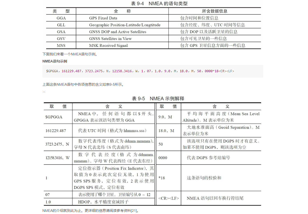
FusedLocationProvider && PassiveLocationProvider
https://www.kancloud.cn/alex_wsc/android-wifi-nfc-gps/414155 深入理解Android
https://www.kancloud.cn/alex_wsc/android-wifi-nfc-gps/414155      深入理解Android


1.GpsLocationProvider
Android平台中能提供位置服务的相关模块统称为Location Provider(位置提供者,LP)。
位置提供者必须实现LocationProviderInterface接口。这些接口对应的对象实例由LMS来创建和管理。
在所有这些位置提供者中,Android Framework实现了其中的 PassiveLocationProvider 和 GpsLocationProvider。


2.NetLocationProvider
当手机使用网络定位时,它首先向服务器查询自己所连接或搜索到的基站位置或AP的位置,然后根据信号的强度推算自己的大致位置。
相比GPS定位而言,网络定位速度快,耗电少,适用于室内和室外,但精度较GPS差。
Android原生代码并不提供Network Location Provider相关的功能,
它一般由第三方应用厂商提供,例如Google的GMS(Google Mobile Service)包中有一个NetworkLocation.apk就提供了该功能,
而国内上市的手机则使用百度公司提供的NetworkLocation_Baidu.apk


3.FusedLocationProvider是一个比较有意思的LP。
它本身不能提供位置信息,其内部将综合GpsLP和NetworkLP的位置信息,然后向使用者提供最符合使用者需求的数据。
即它能根据使用者对电源消耗、精度两方面的要求以选择GpsLP或/和NetworkLP作为真实的LP.

同时,FusedLP能选择GpsLP或NetworkLP提供的位置信息中最好的那一个返回给使用者

简单点说,FusedLP出现之前,一个比较完善的LP客户端需要同时操作和管理GpsLP和NetworkLP,而有了FusedLP后,
客户端只需要使用它即可,其余事情由FusedLP内部来管理。
注意,FusedLP也由应用程序提供,它运行在FusedLocationProvider.apk所在的进程中。


4.PassiveLocationProvider

该 PassiveLocationProvider LP名称中的Passive(译为“被动”)所对应的场景比较有意思


	此处举一个例子。假设应用程序A使用GpsLP。GpsLP检测到位置更新后将通知应用程序A。应用程序B
	如果使用PassiveProvider,当GpsLP更新位置后,它也会触发PassiveProvider以通知应用程
	序B。也就是说,PassiveProvider自己并不能更新位置信息,而是靠其他LP来触发位置更新的。
	特别注意,PassiveProvider的位置更新是由LMS接收到其他LP的位置更新通知后主动调用
	PassiveProvider的updateLocation函数来完成的。


    目前,PassiveProvider被SystemServer中的TwilightService使用,TwilightService
	将根据位置信息来计算当前时间是白天还是夜晚(Twilight有“黎明”之意)。
	另外,GpsLP也会使用PassiveProvider来接收NeworkLP的位置信息。
LP的ProviderProperties
/*
获取LP的属性信息,这些属性统一封装在类型为ProviderProperties的对象中,LP的属性
由ProviderProperties的成员变量表示,这些变量如下。
mRequiresNetwork:是否需要使用网络。
mRequiresSatellite:是否需要使用卫星。
mRequiresCell:是否需要使用基站。
mHasMonetaryCost:是否需要计费。
mSupportsAltitude:是否能提供海拔高度信息。
mSupportsSpeed:是否提供速度信息。
mSupportsBearing:是否支持方位信息。
mPowerRequirement:耗电量级别,可取值有Criteria类定义的HIGH、MEDIUM和LOW三种级别。
mAccuracy:精度级别,可取值有Criteria类定义的COARSE、FINE、HIGH、LOW四种级别。
*/
properties = service.getProperties();
请求位置更新代码实例
		mLocationManager.requestLocationUpdates(provider, TEN_SECONDS,TEN_METERS,listener);
		location = mLocationManager.getLastKnownLocation(provider);


	/*
		调用LocationManager的requestLocationUpdates函数,该函数用于注册一个回调函数以
		接收位置变化信息,其各个参数的作用如下。
		provider:用于指明使用哪个LP,目前可取参数有“gps”(对应为GpsLP)、“network”(对应为NetworkLP)、“passive”(对应为PassiveProvider)。
		TEN_SECONDS:用于指明多少毫秒更新一次位置数据,本例中使用的值为10秒。
		TEN_METERS:用于指明位置变化多少时更新一次数据,本例中使用的值为10米。
		listener:类型为LocationListener,当位置发生变化时,其onLocationChanged函数将被调用。
		*/
GeofenceManager 地理围栏
【台铃电动车__就有一个地理围栏功能,当设置地理围栏范围后1km的圆心 电动车离开这个区域就会报警提示 到手机】
GeofenceManager为地理围栏管理对象。Android平台中其作用如下。
	客户端可以设置一个地理围栏,该地理围栏的范围是一个以客户端设置的某个点(指定其经/纬度)为中心
	的圆,圆的半径也由客户端设置。当设备进入或离开该地理围栏所覆盖的圆时,LMS将通过相关回调函
	数通知客户端。目前Android 4.2中还没有在SDK中公开地理围栏相关的API。有需要使用该功能
	的程序可通过Java放射机制调用LocationManager的addGeofence函数。
GPS_CAPABILITY_SCHEDULING
Android平台中定义的GPS引擎工作能力取值有如下几种。

GPS_CAPABILITY_MSB:如果设置,则GPS模块支持Mobile Service Based AGPS。

GPS_CAPABILITY_MSA:如果设置,则GPS模块支持Mobile Service Assisted AGPS。

GPS_CAPABILITY_SINGLE_SHOT:如果设置,表明GPS模块支持单次定位。与单次定位相对应的是连续定位。

GPS_CAPABILITY_ON_DEMAND_TIME:GPS在工作周期内可能需要UTC时间信息。如果设置此能力,
    GPS模块在需要UTC时间信息时将主动通过相关回调函数(即代码中的requestUtcTime函数,JNI层也会直接调用它)从GpsLP那获取UTC时间。如果没有设置它,则GpsLP将每隔24小时获取UTC时间并输入给GPS模块。
GPS_CAPABILITY_SCHEDULING表示GPS模块支持连续定位,即GPS模块会不断更新位置信息。

GPS_CAPABILITY_SINGLE_SHOT表示GPS模块支持单次定位,即只GPS模块只会通知一次位置信息。单次定位功能适用于那些无需连续获取位置信息的应用程序。
单次定位功能适用于那些无需连续获取位置信息的应用程序。这样,GPS通知完位置信息后即可停止工作以节省电力。
reportSvStatus
private void reportSvStatus() {

int svCount = native_read_sv_status(mSvs, mSnrs,mSvElevations, mSvAzimuths, mSvMasks);

	/*
	下面这个函数用于从GPS HAL层读取卫星的状态,其返回值为卫星的个数。
	该函数每个参数的类型都是一个int数组,其中,除最后一个参数对应的int数组元素个数为3外,
	而其他参数的int数组元素个数为MAX_SVS(值为32),每个参数的作用如下。
	mSvs:用于存储卫星的编号。
	mSnrs:用于存储卫星的SNR(信号噪声比)。
	mSvElevations:存储卫星的高度信息。
	mSvAzimuths:存储卫星的方位信息。
	mSvMasks:该数组包含三个整型值,每个整型值字长32位,分别对应32颗卫星。
	EPHEMERIS_MASK(值为0):该变量的每一位代表GPS模块是否获取了该卫星的ephemeris数据。
	ALMANAC_MASK(值为1):该变量的每一位代表GPS模块是否获取了该卫星的almanac数据。
	USED_FOR_FIX_MASK(值为2):该变量的每一位代表该卫星是否参与了上一次的定位信息计算。【Used In Fix:】
	*/
native_set_position_mode设置工作模式
设置工作模式 native_set_position_mode   API

native boolean native_set_position_mode(int mode, int recurrence, int min_interval,int preferred_accuracy, int preferred_time);

/*
  设置GPS模块工作模式,其各个参数取值含义如下:
mode:GPS工作模式,目前可取值有
         GPS_POSITION_MODE_STANDALONE(值为0,仅GPS工作),
         GPS_POSITION_MODE_MS_BASED(值为1,AGPS MSB模式),
         GPS_POSITION_MODE_MS_ASSISTED(值为2,AGPS MSA模式)

recurrence:位置更新模式,目前可取值有
    GPS_POSITION_RECURRENCE_PERIODIC(值为0,连续定位)、
    GPS_POSITION_RECURRENCE_SINGLE(值为1,单次定位)

min_interval:最短位置更新时间,单位为毫秒

preferred_accurary: 期望的位置更新精度,单位为米

preferred_time:期望的TTFF时间,单位为毫秒

*/
GpsLocationProvider.java JNI接口
//初始化JNI层相关的类型
native void class_init_native();
//判断系统是否支持GPS
native boolean native_is_supported();
//初始化GPS HAL层模块
native boolean native_init();
//清理GPS HAL层模块所分配的资源
native void native_cleanup();
/*
  设置GPS模块工作模式,其各个参数取值含义如下:
  mode:GPS工作模式,目前可取值有GPS_POSITION_MODE_STANDALONE(值为0,仅GPS工作),
         GPS_POSITION_MODE_MS_BASED(值为1,AGPS MSB模式),GPS_POSITION_MODE_MS_ASSISTED
         (值为2,AGPS MSA模式)
  recurrence:位置更新模式,目前可取值有GPS_POSITION_RECURRENCE_PERIODIC(值为0,连续
               定位)、GPS_POSITION_RECURRENCE_SINGLE(值为1,单次定位)
  min_interval:最短位置更新时间,单位为毫秒
  preferred_accurary: 期望的位置更新精度,单位为米
  preferred_time:期望的TTFF时间,单位为毫秒
*/
native boolean native_set_position_mode(int mode, int recurrence, int min_interval,
            int preferred_accuracy, int preferred_time);
//下面这个两个函数用于启动和关闭导航
native boolean native_start();
native boolean native_stop();
//删掉AGPS辅助数据,其flags参数的取值请读者阅读GpsLocationProvider.java的deleteAidingData函数
native void native_delete_aiding_data(int flags);
//读取卫星信息,该函数在“reportStatus和reportSvStatus介绍”一节中已介绍过了
native int native_read_sv_status(int[] svs, float[] snrs,
            float[] elevations, float[] azimuths, int[] masks);
//读取NMEA数据
native int native_read_nmea(byte[] buffer, int bufferSize);
//输入位置信息,在GpsLP中,该位置信息由NetworkLP提供
native void native_inject_location(double latitude, double longitude, float accuracy);

/*
输入NTP时间,其中:
time:为NtpTimeTrustedTime从网络中获取到的NTP时间
timeReference:为设备从开机到一次NTP请求处理成功后的所耗费的时间,由SystemClock的elapsedRealtime
                  函数返回
uncertainty:准确度。在Android系统中,该值为NTP请求发送和接收往返时间的一般。详情可参考
                       SnetpClient.java文件
*/
native void native_inject_time(long time, long timeReference, int uncertainty);
//GPS模块是否支持XTRA数据
native boolean native_supports_xtra();
//输入XTRA数据,即LTO数据
native void native_inject_xtra_data(byte[] data, int length);
//用于调试,获取GPS模块内部状态
native String native_get_internal_state();

//打开AGPS数据下载通道,参数apn指明了所要使用的APN
native void native_agps_data_conn_open(String apn);
//关闭AGPS数据下载通道
native void native_agps_data_conn_closed();
//GpsLP处理AGPS相关事宜失败时候调用下面这个函数
native void native_agps_data_conn_failed();
//将来自数据短信或WAP推送短信得到的信息传递给GPS模块。
native void native_agps_ni_message(byte [] msg, int length);
//设置AGPS服务端地址,其中type取值有两种:
//AGPS_TYPE_SUPL:值为1,代表SUPL服务器
//AGPS_TYPE_C2K:值为2,代表C2K服务器
native void native_set_agps_server(int type, String hostname, int port);

/*
当GPS模块需要使用APGS时,会调用reportNiNotification函数(详情见下文)以通知用户。
用户处理完后,将通过下面这个函数告知GPS模块处理结果。注意,这部分内容涉及到OMA-SUPL相关知识,请读者
阅读参考资料[28]。
该函数的参数如下:
notificationId:通知id,代表GPS HAL层的某一个处理请求
userResponse有三种取值,分别是GPS_NI_RESPONSE_ACCEPT(值为0,代表用户允许相关操作)、
               GPS_NI_RESPONSE_DENY(值为1,用户拒绝相关操作)、GPS_NI_RESPONSE_NORESP
               (值为2,代表用户无回应)。NI和GpsNetInitiatedHandler有关,读者可自行研究它
*/
native void native_send_ni_response(int notificationId, int userResponse);
/*
   设置AGPS参考位置信息,其各参数解释如下:
   type:取值可为AGPS_REF_LOCATION_TYPE_GSM_CELLID(值为1,代表GMS网络的cell id)、
         AGPS_REF_LOCATION_TYPE_UMTS_CELLID(值为2,代表CDMA网络的cell id)、
         AGPS_REG_LOCATION_TYPE_MAC(值为3,代表MAC地址)
   mcc:Mobile Country Code(移动国家码),由3位数字组成,唯一地识别移动用户所属的国家,中国为460
   mnc:Mobile Network Code(移动网络码),用于识别移动用户所归属的移动网络。中国移动TD系统使用00,
         中国联通GSM系统使用01,中国移动GSM系统使用02,中国电信CDMA系统使用03
   lac:Location Area Code(位置区码)。移动通信中,为了确定终端台的位置,每个移动网络的覆盖区都被划分
        成许多位置区,位置区码(LAC)则用于标识不同的位置区。
   cid:cell id(基站编号)
*/
native void native_agps_set_ref_location_cellid(int type, int mcc, int mnc,
            int lac, int cid);
/*
设置终端与移动网络相关的一些参数信息,其type参数决定了setid参数的取值。type可取值有:
type: AGPS_SETID_TYPE_NONE,值为0,无意义
       AGPS_SETID_TYPE_IMSI,值为1,代表IMSI(international mobiles subscriber identity,
       国际移动用户号码标识)。IMSI信息存储在SIM卡上。
      AGPS_SETID_TYPE_MSISDN,值为2,代表Mobile Subscriber ISDN(用户号码),即手机号码
*/
native void native_agps_set_id(int type, String setid);

/*
  通知GPS HAL层系统当前网络的状态,其各参数解释如下:
  connected:网络是否连接
  type:网络类型,可取值请参考ConnectivityManager中各网络类型的定义情况。常用的有TYPE_MOBILE、
         TYPE_WIFI等
  roaming:是否处于漫游状态
  available:网络是否可用
  extraInfo:附加信息
  defaultAPN:默认APN
*/
native void native_update_network_state(boolean connected, int type,
            boolean roaming, boolean available, String extraInfo, String defaultAPN);
//GPS模块汇报位置信息
void reportLocation(int flags, double latitude, double longitude, double altitude,
            float speed, float bearing, float accuracy, long timestamp):
//GPS模块通知GPS工作状态
void reportStatus(int status):
//GPS模块通知卫星状态
void reportSvStatus():
//GPS模块通知AGPS状态
void reportAGpsStatus(int type, int status, int ipaddr):
//GPS模块通知NMEA信息
void reportNmea(long timestamp):
//GPS模块通知GpsLP自己的能力
void setEngineCapabilities(int capabilities):
//GPS模块要求下载XTRA数据
void xtraDownloadRequest():
//GPS模块通知Network Initiated通知,其各参数解释如下:
void reportNiNotification(
            int notificationId,//GPS HAL层分配的通知ID
            int niType,//NI类型,可取值请参考gps.h的GpsNiType的定义
            int notifyFlags,//标志信息,可取值请参考gps.h的GpsNiNotifyFlags定义
            int timeout,//等待用户处理的超时时间
            //当超时发生后,系统采用的默认处理结果。其取值和native_send_ni_respons中第二个参数一样
            int defaultResponse,
            String requestorId,//代表请求者的id
            String text, //通知信息
            int requestorIdEncoding,//requestorId的编码格式,参考gps.h GpsNiEncodingType的定义
            int textEncoding,//text的编码格式
            String extras  //附加信息
        ):
//要求获取参考位置信息,flags参数目前没有使用
void requestRefLocation(int flags):
//要求设置移动网络相关信息,flags参数表示要获取什么样的信息,可取值同native_agps_set_id的type参数
//一致
void requestSetID(int flags):
//要求获取UTC时间
void requestUtcTime():
gps.h::GpsInterface结构体
typedef struct {
     size_t          size;//GpsInterface结构体的长度
   //初始化GPS模块。其参数为GPS模块所需的回调函数
    int   (*init)( GpsCallbacks* callbacks );
   //下面这两个函数用于开启或关闭导航
    int   (*start)( void );
    int   (*stop)( void );
    //清理GPS模块所分配的资源
    void  (*cleanup)( void );
    //输入UTC时间,参数解释同native_inject_time
    int   (*inject_time)(GpsUtcTime time, int64_t timeReference,int uncertainty);
    //输入位置信息,参数解释同native_inject_location
    int  (*inject_location)(double latitude, double longitude, float accuracy);
   //删除赋值信息,其参数解释同native_delete_aiding_data
    void  (*delete_aiding_data)(GpsAidingData flags);
   //设置GPS模块的工作模式,其参数解释同native_set_position_mode
    int   (*set_position_mode)(GpsPositionMode mode, GpsPositionRecurrence recurrence,
            uint32_t min_interval, uint32_t preferred_accuracy, uint32_t preferred_time);
   //获取GPS模块实现的扩展接口,AGPS扩展接口对应的name为“agps”、xtra扩展接口对应的name为“xtra”
   const void* (*get_extension)(const char* name);
} GpsInterface;
gps.h::AGpsInterface

typedef struct {
    size_t          size;
    //初始化AGPS模块
    void  (*init)( AGpsCallbacks* callbacks );
    //打开AGPS数据连接,其参数解释同native_data_conn_open
    int  (*data_conn_open)( const char* apn );
    //关闭AGPS数据连接,其参数解释同native_data_conn_close
    int  (*data_conn_closed)();
    //AGPS数据连接操作失败,同native_data_conn_fail
    int  (*data_conn_failed)();
    //设置AGPS服务器地址等相关信息,参数解释同native_agps_set_server
    int  (*set_server)( AGpsType type, const char* hostname, int port );
} AGpsInterface;
NILR
NILR === Network Initiated Location Request === 网络初始化的位置请求
NILR (Network Initiated Location Request) 是一种网络初始化的位置请求协议,通常用于手机定位。
它允许设备在没有用户直接参与的情况下,通过网络请求位置信息。

典型场景是  美国拨打911时手机会自动发出 NILR 请求 使得警方能知道报警人的位置信息

在SUPL的术语体系中,SET Initiated 和 Network Initiated 与 MOLR 和 NILR 是一一对应的关系,只是描述角度不同。
APN
APN === Access Point Name === 接入点名称
APN是可以从网络运营商或服务提供商处获得接入点的名称。
APN决定了手机通过哪种接入方式来访问网络,用来标识GPRS的业务种类


APN打开和关闭的设置路径:
打开方法:进入「设置>移动网络/SIM卡与流量管理/双卡与移动网络>选择一张SIM卡>接入点名称>点击右上角的+即可新建APN」。


关闭方法:进入「设置>移动网络/SIM卡与流量管理/双卡与移动网络>选择一张SIM卡>接入点名称>找到需要操作的APN」,点击进去删除即可(删除APN可能会影响到网络使用,慎重选择)。


重置APN:进入「设置>移动网络/SIM卡与流量管理/双卡与移动网络>选择一张SIM卡>接入点名称>点击右上角的“:”或“_”图标」选择重置接入点,重置接入点将删除所有自定义接入点。
GPS缩词统计
https://blog.csdn.net/laopolina83/article/details/7996668
1 PPM - 1 Pulse Per Minute
1 PPS - 1 Pulse Per Second
14AF - 14th Air Force, USAF
19SOPS
19th Space Operations Squadron, USAF
1-D - One-dimensional
1SOPS
1st Space Operations Squadron, USAF
2-D - Two Dimensional
2DRMS
Two times the standard deviation or Twice Distance Root Mean
2SOPS
2nd Satellite Operations Squadron, USAF
3-D - Three Dimensional
4-D
Four Dimensional (3-D plus time)
A/C - Aircraft
A/D - Analog to Digital
A/J - Anti-Jamming
AAATS
Australian Advanced Air Traffic Services
ABAS
Aircraft-based Augmentation Systems
ABM - Abeam
ACI
Allocated Configuration Identification
ACU - Antenna Control Unit
ACSM
American Congress on Surveying and Mapping
A/D - Analog To Digital
ADC - Analog to digital converter
ADF - Automatic Direction Finder
ADI - Attitude Director lndicator
ADIU - Advanced Digital Interface Unit
ADP - Automated Data Processing
ADR - Accumulated Delta Range
ADS
Automatic Dependent Surveillance
AE - Antenna Electronics
AECB - Atomic Energy Control Board
AF - Air Force
AFB - Air Force Base
AFI - Automatic Fault Indication
AFSPC - Air Force Space Command
AGL - Above Ground Level
AHRS
Attitude Heading Reference System
AI - Artificial Intelligence
AIAA
American Institute of Aeronautics and Astronautics
AIS - Automated Information System
AJ - Antijamming
ALT - Alternate
ALT - Altitude
AM - Amplitude Modulation
AM/FM
Automated Mapping and Facilities Management
AMCS - Alternate Master Control Station
ANE - Autonomous Navigation Emulator
ANSI
American National Standards Institute
ANTB - Advanced Navigation Test Bed
AoA - Analysis of Alternatives
AOA - Airport Operations Area
AOA - Angle-of-Attack
AOC - Aeronautical Operation Control
AOC - Auxiliary Output Chip
AOC - Auxiliary Output Chip
AOCS - Attitude and Orbit Control System
AOM - Aircraft Operating Manual
AOO - Area of Operations
AOPA
Aircraft Owners And Pilots Association
AOR - Area of responsibility
AORP
Airfield Obstruction Reduction Program
AP - Acquisition Plan
APA - Airline Pilots Association
APMS
Automated Performance Measurement System
APPR - Approach/Approach Mode
APPS
Analytical Photogrammetric Positioning System
APR - April
APU - Auxiliary Power Unit
AQP - Advanced Qualification Program
ARGO - Automatic Ranging Grid Overlay
ARNS - Aeronautical Radio Navigation Service
ARPA - Advanced Research Projects Agency
ARR - Arrival
ARTCC - Air Route Traffic Control Center
ARTS - Automated Remote Tracking Station
ARTS - Automated Radar Terminal System
AS - AntiSpoofing
ASCII
American Standard Code for Interface and Interchange
ASF - Additional Secondary Factor (Loran-C)
ASI - Air Speed Indicator
ASIC - - Application Specific Integrated Circuit
ASPRS
American Society of Photogrammetry and Remote Sensing
ASR - Airport Surveillance Radar
ATA - Air Transport Association
ATC - Air Traffic Control
ATCS - Advanced Train Control Systems
ATCSCC
Air Traffic Control System Command Center
ATE - Automatic Test Equipment
ATM - Air Transportation Management
ATON - Aids To Navigation
ATS - Automatic Throttle System
AUG - August
Autonav - Autonomous Navigation
AVAIL - Available
AVL - Automatic Vehicle Location
AVL - Automatic Vehicle Location -
AVLN
Automatic Vehicle Location And Navigation
Civic Address
此信息元素包含目标UE的位置估计,表示为Civic地址。


This IE contains a UTF-8 encoded  PIDF-LO XML document as defined in
IETF RFC 4119 [13]. The document shall only contain a civic address using the namespaces
"urn:ietf:params:xml:ns:pidf:geopriv10:civicAddr" per IETF RFC 5139 [14] and
"urn:ietf:params:xml:ns:pidf:geopriv10:civicAddr:ext" per IETF RFC 6848 [15]
AVM - Automatic Vehicle Monitoring
AWACS - Airborne Warning And Control System
AWAS - Automated Weather Advisory Station
AWIPS
Advanced Weather Interactive Processing System
B - Billion
BBS - Bulletin Board Service
BCD - Binary Code Decimal
BER - Bit Error Rate
BIPM
International Bureau of Weights and Measures
BITE - Built-in Test Equipment
BMCS
Backup Master Control Station (MCS)
Bps - Bits per second
BPSK - Binary Phase Shift Keying
BRG - Bearing
BRT - Brightness
BUMCS - Back-up Master Control Station
C - Centigrade
C&A - Certification and Accreditation
C/A - Coarse Acquisition Code
C/No - Carrier to Noise Ratio
C/PD - Cost/Pricing Data
C2 - Command and Control
C3 - Command, Control, and Communications
C3I
Command, Control, Communications, and Intelligence
CAD - Computer Aided Design
CASE - Computer Aided Software Engineering
CAT - Computer Aided Testing
CBD - Commerce Business Daily
CBT - Computer Based Training
CCB - Configuration Control Board
CCW - Continuous carrier wave
CCW - Coded Continuous Wave
CCZ - Coastal And Confluence Zone
CDMA - Code Division Multiple Access
CDU - Control Display Unit
CDMA
Code Division Multiple Access (GPS)
CEP - Circular error probable
CG - Center of Gravity
CGS - Centimeter-gram-second
Cl - Cost Index
CLR - Clear
cm - Centimeter
CM - Configuration Management
CMG - Command Managers Guide
CMOS - Complementary Metal Oxide Semiconductor
CMC - Central Maintenance Computer
CMP - Configuration Management Plan
CMS - Command Management Seminar
CNA - Computer Network Attack
CNS -
Communications, Navigation, And Surveillance
CO
Contracting Officer; Change Order; Commanding Officer; Colorado
COE
Common Operating Environment; Center of Expertise
CONOPS - Concept of Operations
COP - Circle Of Position
CONUS - Continental United States
CORS -
Continuously Operating Reference Station
COTS - Commercial Off-The-Shelf
CPU - Central Processing Unit
CRPA - Controlled Radiation Pattern Antenna
CRT - Cathode Ray Tube
CRYPTO - cryptographic
CS - Control Segment
CTR - Center
CSAT - Constellation System Assessment Team
CTRL - Control
CTS - Colorado Tracking Station
CUE - Common User Element
CVNS - carrier navigation systems
CW - Continuous Wave
CY - Calendar Year
D/A - Digital To Analog
D/D - Drift Down
DAC - Digital to Analog Converter
DATALINK
Digitized Information Transfer (air/ground)
dB - Decibel (X = 10 Log X dB)
DBS - Direct Broadcast Satellite
dBW - decibels per watt
DC - Direct Current Electricity
DEC - December
DECR - Decrement
DEG - degree
DEL - Delete
DEP - Departure
DEV - Deviation
DF - direction finding
DGIC - Differential GPS Integrity Channel
DGNS - Doppler GPS Navigation System
DGPS
Differential Global Positioning System
DH - Decision Height
DID - Data Item Description
DIS - Distance
DISCR - Discrepancy
DIST - Distance
DLL - Delay Lock Loop
DLM - Data Loader Module
DLR - Data Loader Receptable
DLS - Data Loader System
DLT - Data Link Terminal
DMA - Defense Mapping Agency
DME - Distance Measuring Equipment
DMU - Data Management Unit
DoD - Department Of Defense
DOE - Department of Energy
DOP - Dilution Of Precision
DoT - Department Of Transportation
DR - Dead Reckoning
DRMS - Distance Root Mean Square
DRS - Dead Reckoning System
DRU - Data Retrival Unit
DT&E - Development Test and Evaluation
DTG - Distance-to-go
E - East
EA
Electronic Attack; Evolutionary Acquisition
ECDIS
Electronic Chart Display And Information System
ECEF - Earth Centered, Earth Fixed
EDM - Electronic Distance Measurement
EGNOS - European Geostationary Navigation Overlay Service
EOS - Earth Orbiting System
EPROM - Erasable Programmable Read-Only Memory
EHF - Extremely High Frequency
ETA - Estimated Time Of Arrival
ECE - Earth-Centered-Earth-Fixed
ECEF - Earth Centered, Earth Fixed
ECM - Electronic Countermeasures
ECP - Engineering Change Proposal
ECS - Environmental Control System
EDM - Electronic Distance Measurement
EFIS - Electronic Flight Instrument System
EHF - Extremely High Frequency
EHSI
Electronic Horizontal Situation Indicator
EIU - Electronic Interface Unit
EKMS - Electronic Key Management System
ELEV - Elevation
ELT - Emergency Locator Transmitter
EM - Electro Magnetic
EMC - Electromagnetic Compatibility
EMCON - Emission Control
EMI - Electromagnetic Interference
EMP - Electromagnetic Pulse
EMS - Emergency Medical Services
ENG - Engine
EOL - End of Life
EOW - End of Week
EPR - Engine Pressure Ratio
EPROM
Erasable Programmable Read-Only Memory
EPS - Electric Power System
ES - Electronic Support
ESGN - Electrically Suspended Gyro Navigator
ESM - Electronic Support Measures
EST - Estimated
ETA - Estimated Time of Arrival
ETX - End of Transmission
EU - European Union
EW - Electronic Warfare
EXEC - Execute
Exp - Exponential Function
F - Fahrenheit
f - Frequency
FAA - Federal Aviation Administration
FAATC
FAA Technical Center - Atlantic City, New Jersey
FADEC - Full Authority Digital Engine Control
FANS - Future Air Navigation Systems
FAR - Federal Acquisition Regulation
FBO - Fixed Based Operator
FCC - Federal Communications Commission
FCC - Flight Control Computer
FCMDR - Flight Commander
FCU - Flight Control Unit
FD - Fault Detection
FDE
Fault Detection Equipment; Fault Detection and Exclusions
FDMA - Frequency Division Multiple Access -
FDR - Flight Data Recorder
FEB - February
FHWA - Federal Highway Administration
FLT - Flight
FI - Fault Isolation
FL - Florida
FM - Frequency Modulation
FMEA Failure Mode and Effects Analysis
FMS - Flight Management Systems
FO - First officer
FOC - Full Operational Capability
FOM - - Figure Of Merit
FOIA - Freedom of Information Act
FOUO - For Official Use Only
FPA - Focal Plane Array
FPM - Feet Per Minute
FQIS - Fuel Quantity Indicating System
FR - From
FRA - Federal Railroad Administration
FRA - Flap Retraction Altitude
FREQ - Frequency
FRP - Federal Radionavigation Plan
FRPA - Fixed Radiation Pattern Antenna
FRPA-GP - FRPA Ground Plane
FSS - Federal Supply Schedule
FT - Feet
FY - fiscal year
GA - General Aviation
GA - Ground Antenna
GANS - global access, navigation and safety
GAO - General Accounting Office
GATM - Global Air Traffic Management
GBAS - Ground-based augmentation system
Gbps - Gigabits per second
GDOP - Geometric Dilution Of Precision
GEO - Geosynchronous Earth Orbit
GEOREF - World Geographic Reference System
GHz - Gigahertz
GIAC - GPS Interagency Advisory Council
GIB - GPS Integrity Broadcast
GIC - GPS Integrity Channel
GIS - Geographic Information Systems
GLONASS - Global Navigation Satellite System
GMT - Greenwich Mean Time
GNSS - Global Navigation Satellite Systems
GPS - Global Positioning System
GPSE - GPS Enhancement
GPSIC - GPS Information Center
GRAS - Ground-based regional augmentation system
GRP - Geographical Reference Points
GRS - Geodetic Reference System
GTP
GTP === Global Terrestrial Positioning === 高通的xtra定位技术的升级版本
Qualcomm Global Terrestrial Positioning (GTP) is formerly known as XTRA-T.

Qcom xtra 导航定位下载
GS - Glide Slope
GS - Ground Speed
GSA - General Services Administration
GSA === GPS DOP and Active Satellites 当前卫星信息
GW - Gross Weight
GYRO - gyroscope
GSV
GSV == GPS Satellites in View == 可见GPS卫星信息
GNS
GNS === Global Positioning System Fix Data(GNS) === GPS 定位信息
GGA
GGA === Global Positioning System Fix Data(GNS) === 全球定位系统固定数据 提供定位信息和时间数据
GGA(Global Positioning System Fix Data)是 NMEA-0183 协议中的一种数据格式,
用于提供 GPS 定位信息,包括时间、经纬度、卫星数量、定位质量等信息
GLL
GLL === Geographic Position - Latitude/Longitud === 提供位置和时间数据
HADGPS - High Accuracy DGPS
HANU - High Accuracy Navigational Users
HD - High dynamic
HDG - Heading
HDG - SEL - Heading Select
HDOP - Horizontal Dilution of Precision
HF - High Frequency
HHA - Harbor And Harbor Approach
HF - high frequency
HIRS - High-Resolution Infrared Sounder
HMI - Hazardously Misleading Information
HR - relative height
HUD - Head-Up Display
HV - Host Vehicle
Hz - Hertz (cycles per second)
IALA
International Association Of Lighthouse Authorities
ICAO - International Civil Aviation Organization
ICD - Interface Control Document
ICS - Interim Control Segment
ID - Identifier
ICWG - Interface Control Working Group
IDD - Interface Design Document
IEEE
Institute Of Electrical And Electronics Engineers
IERS - International Earth Rotation Service
IF - Intermediate Frequency
IFF - Identification Friend or Foe
IFR - Instrument Flight Rules
IF - Intermediate Frequency
IGEB - Interagency GPS Executive Board
IG - Inspector General
IGS - International GNSS Service
ILS - Instrument Landing System
IMO - International Maritime Organization
INFO - Information
IFRB - International Frequency Registration Board
INIT - Initialization
INMARSAT - International Maritime Satellite
INR - Image Navigation and Registration
INS - Inertial Navigation System
INTC - Intercept
IOC - Initial Operational Capability
ION - Institute Of Navigation
IOT&E - Initial Operational Test and Evaluation
IP - Instrumentation Port
IPT - Integrated Product Team
IRD - Interface Requirements Document
IRS - Inertial Reference System
IRT - Independent Review Team
IRU - Inertial Reference Unit
ISA - International Standard Atmosphere
ISO - International Standards Organization
ITP - Integrated Test Plan
ITRF - International Terrestrial Reference Frame
ITS - Intelligent Transportation System
ITU - International Telecommunication Union
IV&V
Independent Verification and Validation
IVHS
Intelligent Vehicle Highway Systems IW Information Warfare
J/S - Jamming to Signal Ration
JAN - January
JCS - Joint Chiefs of Staff
JPALS -
Joint Precision Approach and Landing System
JPL - Jet Propulsion Laboratory
JPO - Joint Program Office
JROC
Joint Requirements Oversight Council
JSRA - Joint Sponsored Research Agreement
JSST - J oint Space Support Team
JSTARS
Joint Surveillance, Target Attack Radar System
JTF - Joint Task Force
JTIDS
Joint Tactical Information Distribution System
JUL - July
JUN - June
K - Thousand
Kbps - Kilo bits per second
KG - Kilogram
kHz - kilohertz
KHz - Kilohertz
km - Kilometer
KT - (kts) - Knots
kW - Kilowatt
L - Link
L - Left
L1 - GPS Carrier Frequency, 1575.42 MHz
L2 - GPS Carrier Frequency, 1227.6 MHz
LAAS - Local Area Augmentation System
LAN - Local Area Network
Lat - Latitude
Lat/Lon - Latitude/Longitude
LBS - L Band System
L2C - Civil signal on L2
L2M - Military-code on L2
L5 - Link 5, carrier frequency = 1176.45 MHz
LAAFB - Los Angeles Air Force Base
LAAS - Local Area Augmentation System
LAN - Local Area Network
LAT - latitude
LCD - Liquid Crystal Display
LCN - Local Communications Network.
LED - Light Emitting Diode
LEO - Low Earth Orbit
LEP - Linear Error Probable
LED - Light emitting diodes
LEO - Low Earth Orbit
LEP - linear error probable
LF - low frequency
LFR - Low-frequency Radio Range
LIM - Limit
LIS - Land Information System
LF - Low Frequency
LO - Local Oscillator
LO - Low
LOC - Localizer Beam
Lon - Longitude
LOP - Line Of Position
Loran - Long Range Navigation
LOS - Line Of Sight
LRC - Long Range Cruise
LRU - Line Replaceable Unit
M - Mach Number
m - Meter(s)
M - Million
M/S - Meters per Second
MAG - Magnetic
MAINT - Maintenance
MAN - Manual
MAR - March
MAX - Maximum
mB - Millibar
Mbps - Mega bits per second
MC&G - mapping, charting, and geodesy
MCA - Minimum Crossing Altitude
MCDU - Multipurpose Control Display Unit
M-Code - Military Code
MCS - Master Control Station
MCT - Mean Corrective Maintenance Time
MCW - Modulated Continuous Wave
MCW - modulated continuous wave
MD - Maryland
MDL - Multipurpose Data Link
MEL - Minimum Equipment List
MF - Medium Frequency
MGRS - Military Grid Reference System
MHz - Megahertz
MIDAS - Multi-discipline Data Analysis System
mil
unit of angular measurement equal to an angle having a tangent of 0.001
MILSPEC - Military Specifications
MIN - Minimum
MIN - Minutes
MLRS - multiple launch rocket system
MLS - Microwave Landing System
MLV - Medium Launch Vehicle
mm - millimeter
MMD - Mean Mission Duration
MMR - Multi-Mode Receiver
MN - Magnetic North
MNP - Master Navigation Plan
MNS - Mission Need Statement
MOA - Memorandum of Agreement
MOD - Modified/Modification
MODIS - Moderate-resolution Imaging Spectrometer
MOPS - Minimum Operational Performance Standards
MOU - Memorandum of Understanding
MP - Master Plan
MS - Monitor Station
MSAS - MTSAT Augmentation System
MSG - Message
MSK - Minimum Shift Keying
MSS - Mobile Satellite Service
MSL - Mean Sea Level
MTBF - Mean Time Between Failures
MTSAT - Multifunction Transport Satellite
MU - Management Unit
MWP - Meteorological Weather Processor
N - North
N/A - Not Applicable
NACA
National Advisory Committee for Aeronautics
NAD - North American Datum -
NADU - Notice Advisory to DGPS Users
NAGU - Notice Advisory to Glonass Users
NANU - Notice Advisory to Navstar Users
NAS消息
NAS === Non-Access Stratum === 非接入层
NAS(Non-Access Stratum 非接入层 ,NAS负责控制平面信令的传输 负责处理UE和核心网之间的 CP 信令 )


NAS通常指非接入层(Non-Access Stratum),负责处理UE和核心网之间的 CP 信令
NAS - National Aircraft Standard
NAS - National Airspace System
NASA -
National Aeronautics and Space Administration
NATCA -
National Air Traffic Controllers Association
NATO - North Atlantic Treaty Organization
NAV - Navigation
NAVAID - Navigational Aid
NAV-msg - . - Navigation Message
NAVSTAR
Navigational Satellite Timing and Ranging
Navwar - Navigation Warfare
NCA - National Command Authority
ND - Navigation Display
NDB - Nondirectional Radio Beacon
NDGPS
Nationwide Differential Global Positioning System
NDS Nuclear Detection Subsystem
NESDIS
National Environmental Satellite, Data, and Information Service
NGS - National Geodetic Survey
NIMA
National Imagery and Mapping Agency
NIST
National Institute of Standards and Technology
Nl - Engine Revolutions per Minute (percent)
NLM - Network Loadable Module
NLR
National Research Laboratory (The Netherlands)
NM - Nautical Mile
Nm - Nautical Mile
NMC - National Meteorological Center
NNSS
Navy Navigation Satellite System (Transit)
NOAA -
National Oceanic And Atmospheric Administration
NOS - National Ocean Survey
NRL - Naval Research Laboratory
Ns - Nanosecond
NOAA
National Oceanic and Atmospheric Administration
NOCC - National Operations Command Center (FAA)
NORAD - North American Aerospace Defense Command
NOTAM - Notice for Airman
NOV - November
NPA - Non-precision approach
NRL - Naval Research Laboratory
NRP - National Route Program
NS - Nanosecond
NSC - Non-standard C/A code
NSC - National Security Council
NSTC
National Science and Technology Council
NTIS
National Technical Information Service (Department of Commerce)
NTS - Navigation Technology Satellite
NTSB - National Transportation Safety Board
NW - Northwest Airlines
NWS - National Weather Service
###
###
###
OAB - Operational Advisory Broadcasts
OATS - Orbit and Attitude Tracking
OBE - Overtaken by Events
OBS - Omni Bearing Select
OCONUS
Outside the CONUS (Continental United States)
OCS - Operational Control Segment
OEM - Original Equipment Manufacturer
OGE - Operational Ground Equipment
OIS - Orbital Insertion System
OJT - On-the-Job Training
OMB - Office of Management and Budget
ONC - operational navigation chart
OP - Operational
OPCON - operational control
OPSCAP - Operational Status Capability
OPT - Optimum
ORD - Operational Requirements Document
ORRB - Operational Requirements Review Board
ORWG - Operational Requirements Working Group
OS - Operational Stability
OSCARS
Optimum Satellite Constellation Assessment Report Summary
OSD - Office of the Secretary of Defense
P-Code - Precision/Protected Code
PADS - Position Azimuth Determining System
PAFB - Peterson Air Force Base, Colorado Springs, CO
PALS - Precision Approach Landing System
PC - Personal Computer
PDD - Presidential Decision Directive
PDOP - Position Dilution Of Precision
PE - Probable error
PERF - Performance
PHARE
Program for Harmonized ATC Research in Europe
PHIBUF - Performance Buffet Limit
PHMI
Probability of Hazardously Misleading Information
PHINOM - Nominal Bank Angle
PINS - Precise Integrated Navigation System
PLGR - Precise Lightweight GPS Receiver
PMI - Preventative Maintenance Instructions
PMS - Performance Management System
PNT - Position, navigation and time
POC - Point of Contact
POS - Position
POS REF - Position Reference
Pos/Nav - positioning/navigation
PPM - Parts Per Million
PPM - Parts Per Million
PPOS - Present Position
PPS - Precise Positioning Service
PPS - Pulse Per Second
PR - Pseudorange
PREV - Previous
PRN - Pseudo Random Noise
PROM - Programmable Read-Only Memory
PTTI - precise time and time interval
PY - Prior Year
PDR
PDR  === Pedestrian Dead Reckoning === 行人航位推算


PDR是一种基于惯性传感器(如加速度计、陀螺仪和磁力计)的室内定位技术,用于在GPS信号不可用或质量较差的环境中提供位置信息。
其核心思想是通过测量行人的步数、步长和方向,结合初始位置和运动参数,推算出行人的当前位置。


 Indoor /outdoor switch
室内外切换技术旨在解决GPS和PDR之间的无缝衔接问题。

例如,当用户从室外进入室内时,系统会根据GPS提供的初始位置信息切换到PDR模式;
而在用户离开室内环境后,再切换回GPS模式。这种切换通常依赖于传感器融合算法和路径模型的优化,以确保定位的连续性和准确性
QA - Quality Assurance
QC - Quality Control
QTY - Quantity
QUAD - Quadrant
R - Right
R&D - Research and Development
RAD - Radial
RAIM - Receiver Autonomous Integrity Monitoring
RAM - Random Access Memory
RAP - Reserve Auxiliary Payload
RCVR - Receiver
RDF - Radio Direction Finder
RDOP - Relative Dilution of Precision
RDSS - Radio Determination Satellite Systems
REF - Reference
RF - Radio Frequency
RFI - Radio Frequency Interference
RINEX - Receiver INdependent EXchange format
RLG - ring laser gyro
RMS - Root Mean Square
RNAV - Area Navigation
RNP - Required Navigation Performance
ROM - Read-Only Memory
ROV - Remotely Operated Vehicle
RTCA - Radio Technical Commission for Aeronautics
RTCA-SC
Radio Technical Comission for Aeronautics, Special Committee
RTCM - Radio Technical Commission for Maritime Services
RTK - Real-Time Kinematic
RSS - Root Sum Square
RTCA
Radio Technical Commission for Aeronautics
RTCM
Ratio Technical Commission for Maritime Services
RTE - Route
RTS - Remote Tracking Station
RVR - Runway Visual Range
RMC
RMC === Recommended Minimum Specific GPS/Transit Data === 推荐最小定位信息
S - South
S/A - Selective Availability
SA - Selective Availability
SA - Situation Awareness
SA/A-S - selective availability/anti-spoof
SAASM
Selective Availability and Anti-Spoofing Module
SAFB
Schriever Air Force Base (Colorado)
SAR
Selected Acquisition Report;
Subsequent Application Review;
Search and Rescue;
Safety Assessment Report;
Special Access Required
SARPS - Standards and Recommended Practices
SATCOM - Satellite Communications
SATNAV - Satellite Navigation
SBIR
Space Based Infrared System; Small Business Innovation Research Program
SC - Special Committee
SCA
Satellite Control Authority/Architecture
SCAT I - Special Category I
SCATANA
Security Control of Air Traffic and Navigation Aids
SCCB - Software Configuration Control Board
SCI - Sensitive Compartmented Information
SCSS - Satellite Control Simulation System
SDLS - Satellite Data Link Standard
SE - Systems Engineering; Support Equipment
sec - Second(s)
SEL - Selected
SEP - - Spherical Error Probable
SES - Severely Errored Seconds
SF - Sub Frame
SGLS - Space-Ground Link Subsystem
SHF - Super High Frequency
SIGMET
Significant Meteorological Information
SIGSEC - Signal Security
SINS - Shipborne INS
SIS - Signal-In-Space
SKYNET - Skynet Communications Satellite
SLEP - Service Life Extension Program
SLR - Satellite Laser Ranging
SLS - Satellite Launch Squadron
SM - Security Module
SME - Subject Matter Experts
SNAPM
Satellite-Based Navigation Accuracy Performance Model
SNR - Signal To Noise Ratio
SOC - Satellite Operations Center
SOIT
Satellite Operational Implementation Team
SONAR - sound navigation ranging
SOP - Standard Operating Procedure
SOPS
Satellite Operations Squadron
SORD
System of Operational Requirements Document
SP - Space
SPS - Standard Positioning Service
SPU - Spacecraft Processor Unit
SQL - Structured Query Language
SRP - Selected Reference Point
SS - Space Segment
SSG - Senior Steering Group
SSM - Sign Status Matrix
SSN - Space surveillance network
SPS - Standard Positioning Service
STB - System Test Bed
STD - Standard
STS-Space Transportation System
STS
System Telecommunication Simulator, Block IIF
STS/TSM
Satellite Telecommunications Simulator (Block IIF)/Telecom Simulator
SV - Space Vehicle
SVN
Space Vehicle NAVSTAR, Space Vehicle Number
T - Trillion; Time
T&E - Test and Evaluation
TACAN - Tactical Air Navigation
TAI - International Atomic Time
TBD - To Be Determined
TCA - Terminal Control Area
TCAS
Traffic Alert & Collision Avoidance System
TD - Time Difference
TDMA - Time Division Multiple Access
TDOP - Time Dilution of Precision
TE - Test Equipment
TEMP - Temperature
THDG - True Heading
TN - True North
TO T - echnical Order
TOA - Time of Arrival
TOD - Time Of Day
TOPEX - The Ocean Topography Experiment
TOT - Total
TQM - Total Quality Management
TRACON
Terminal Radar Approach Control Facility.
TRANS - Transition
TSO - Technical Standard Order
UAV - Unmanned Aerial Vehicle
UE - User Equipment
UERE - User Equivalent Range Error
UEE - User Equipment Error
UHF - Ultra High Frequency
UNK - Unknown(s)
URE - User Range Error
US - User Segment
USAF - United States Air Force
USCG - United States Coast Guard
USGIC - US GPS Industry Council
USGS - US Geological Survey
USNO - US Naval Observatory
UT - Universal Time
UTC - Coordinated Universal Time
UTC (USNO)
Coordinated Universal Time as maintained by the USNO
V - Velocity
V&V - Verification and Validation
VAR - Variation
VAR - Visual-aural Radio Range
VDOP - Vertical Dilution of Precision
VE - Value Engineering
VFR - Visual Flight Rules
VHF - Very-high Frequency
VLF - very low frequency
VLM - Vehicle Location Monitoring
VMC - Visual Meteorological Conditions
VNAV - Vertical
VOM - Volt-ohm-milliammeter
VOR
very high frequency omnidirectional range station
VOR/DME
Very High Frequency Omnidirectional Range/Distance Measuring Equipment
VORTAC
VHF Omni Range Radio/Tactical Air Navagation
VPATH - Vertical Path
VREF - Reference Velocity
VTC - Vessel Traffic Center
VTOL - Vertical Takeoff and Landing
VTR - Variable Takeoff Rating
VTS - Vessel Traffic Services
=
W - West
WAAS - Wide Area Augmentation System
WADGPS - Wide Area Differential GPS
WAGE - Wide Area GPS Enhancement
WAN - Wide Area Network
Waypoint
Position in space usually on aircraft's flight plan
WGS - World Geodetic System
WGS 84 - World Geodetic System 1984
WPT - Way point
WRC - World Radio Conference
WT - Weight
WWV WWVH - time station call letters
WX - Weather
WXR - Weather Radar
X-BAND
The frequency range between 8000 and 12500 MHz
XCVR - Transceiver
XFR - Transfer
XLTR - Translator
XMIT - Transmit
XMITR - Transmitter
Y code - Precise code (GPS)
Y2K - Year 2000
YD - Yaw Damper
YSAS - Yaw Stability Augmentation System
Z - Zulu (GMT time)
ZDA
ZDA === Data and Time === 时间和日期
zukgit_check_agps_profiles_conf2
<?xml version="1.0" encoding="UTF-8" standalone="yes"?>
<mtk_agps_profiles maj_ver="1" min_ver="2" carrier_xml_enable="true">


<!-- GPS position_mode


up_setting    __>   aosp_pos_mode_enable   true{Bool枚举 true|false(default)}   是否使用AOSP Framework 的 set_position_mode设置的值


public static final int GNSS_POSITION_MODE_STANDALONE = 0;    // 独立定位
public static final int GNSS_POSITION_MODE_MS_BASED = 1;      // MSB 定位(手机为主完成定位 服务器提供星历信息)
public static final int GNSS_POSITION_MODE_MS_ASSISTED = 2;   // MSA 定位(手机提供信息给服务器 手机为辅助  服务器为主完成定位传输给手机)

gedit ./packages/apps/CarrierConfig/res/xml/vendor_asia.xml     // 当前亚洲国家 运营商 配置文件

private static final String DEBUG_PROPERTIES_SYSTEM_FILE = "/etc/gps_debug.conf";
private static final String DEBUG_PROPERTIES_VENDOR_FILE = "/vendor/etc/gps_debug.conf";

public static final String ASSISTED_GPS_ENABLED = "assisted_gps_enabled";   // Settings.java Whether assisted GPS should be enabled or not.


mPositionMode = GNSS_POSITION_MODE_STANDALONE;
boolean agpsEnabled =(Settings.Global.getInt(mContext.getContentResolver(),Settings.Global.ASSISTED_GPS_ENABLED, 1) != 0);
mPositionMode = getSuplMode(agpsEnabled);

PersistableBundle configs = SubscriptionManager.isValidSubscriptionId(subId) ? configManager.getConfigForSubId(subId) : configManager.getConfig();

// public static final String KEY_PREFIX = "gps.";  以 .gps 为开头的 有点像  /packages/apps/CarrierConfig/res/xml/vendor_asia.xml 定义的值了
String key = configKey.substring(CarrierConfigManager.Gps.KEY_PREFIX.length()).toUpperCase(Locale.ROOT);

//CarrierConfigManager.GPS.java
public static final int SUPL_EMERGENCY_MODE_TYPE_CP_ONLY = 0;    //在紧急呼叫时候 仅支持CP 传输位置信息   //Location information during (and after) an emergency call is only provided over control  plane signaling from the network.
public static final int SUPL_EMERGENCY_MODE_TYPE_CP_FALLBACK = 1;   //  在紧急呼叫时候 优先使用 UP 传输位置信息, CP 备用 Location information during (and after) an emergency call is provided over the data plane and serviced by the framework GNSS service
public static final int SUPL_EMERGENCY_MODE_TYPE_DP_ONLY = 2;    //  在紧急呼叫时候 仅仅使用 UP 传输位置信息 , 拒绝CP Location information during (and after) an emergency call is provided over the data plane  and serviced by the framework GNSS service only. There is no backup signalling over the  control plane if it fails.

//CarrierConfigManager.GPS.java 定义的配置值


/** CarrierConfigManager.GPS.java  【gps.persist_lpp_mode_bool】
 *####################################
 *# gps_debug.conf  LTE Positioning Profile Settings
 *####################################
 *# 0: Enable RRLP on LTE(Default)
 *# 1: Enable LPP_User_Plane on LTE
 *# 2: Enable LPP_Control_Plane
 *# 3: Enable both LPP_User_Plane and LPP_Control_Plane
 *#LPP_PROFILE = 2
 * Determine whether current lpp_mode used for E-911 needs to be kept persistently.
 * 决定  用于E911紧急通话的lpp_mode LPP模式  的定义源 来自哪里
 * {@code false} lpp_mode模式来自gps_debug.conf的LPP_PROFILE值   - not keeping the lpp_mode means using default configuration of gps.conf  when sim is not presented.
 * {@code true} lpp_mode模式来自CarrierConfig.xml 中的lpp_profile值,即使移除SIM卡也使用这个  - current lpp_profile of carrier will be kepted persistently even after sim is removed. This is default.
 */
public static final String KEY_PERSIST_LPP_MODE_BOOL = KEY_PREFIX + "persist_lpp_mode_bool";


/** CarrierConfigManager.GPS.java  【gps.supl_host】
 *
 * SUPL server host for SET Initiated & non-ES Network-Initiated SUPL requests. Default to supl.google.com
 * SUPL服务器地址 对于 SET Initiated SI(紧急状态 和 非紧急状态) 和 NI(非紧急状态) 下的 NI SUPL请求, 默认是  supl.google.com
 */
public static final String KEY_SUPL_HOST_STRING = KEY_PREFIX + "supl_host";


/** CarrierConfigManager.GPS.java  【gps.supl_port】
 *
 * SUPL server port. Default to 7275.
 * SUPL服务器地址端口 默认是  7275
 */
public static final String KEY_SUPL_PORT_STRING = KEY_PREFIX + "supl_port";


/** CarrierConfigManager.GPS.java  【gps.supl_ver】
 *
 * The SUPL version requested by Carrier. This is a bit mask with bits 0:7 representing a service indicator field,
 * bits 8:15 representing the minor version and bits 16:23 representing the major version    Default to 0x20000.
 * Carrier要求的SUPL 版本  [0:7_【service indicator服务标志】][8:15_【minor version次版本】][16:23_【major version主要版本】]
 */
public static final String KEY_SUPL_VER_STRING = KEY_PREFIX + "supl_ver";


/** CarrierConfigManager.GPS.java  【gps.supl_mode】
 *
 * 当前的SUPL_MODE位图  SUPL_MODE configuration bit mask
 * 0 - 关闭MSA 和 MSB 仅支持standalone mode 独立定位
 * 1 - MSB(手机为主 完成定位)Mobile Station Based. This is default.
 * 2 - MSA(网络为主 完成定位)Mobile Station Assisted.
 */
public static final String KEY_SUPL_MODE_STRING = KEY_PREFIX + "supl_mode";


/** CarrierConfigManager.GPS.java  【gps.supl_es】
 * Whether to limit responses to SUPL ES mode requests only during user emergency sessions (e.g. E911), and SUPL non-ES requests to only outside of non user emergency sessions.
 * 0 - no  不限制.
 * 1 - yes 限制. This is default 默认为1  .    defaults.putString(KEY_SUPL_ES_STRING, "1"); 默认为1
 * 是否对手机的回复Responses响应进行限制  当手机在 SUPL 紧急状态模式下发出 紧急位置请求
 * 是否对手机的回复Responses响应进行限制  当手机在 非SUPL紧急状态模式下发出的 非紧急位置请求
 * zhushi0f7="1.当紧急呼叫bit  supl_es  为0时 并且 设备 不处于 紧急模式时调用handleNi() 处理常规行为 legacy behaviour         1. When SUPL ES bit is off and UE is not in emergency mode: Call handleNi() to do legacy behaviour."
 * zhushi0f8="2.当紧急呼叫bit  supl_es  为1时 并且 设备 不处于 紧急模式时 忽略 Emergency SUPL_INIT                           2. When SUPL ES bit is off but UE is in emergency mode: Ignore the emergency SUPL INIT. "
 * zhushi0f9="3.当紧急呼叫bit  supl_es  为0时 并且 设备   处于 紧急模式时 忽略 Emergency SUPL_INIT                           3. When SUPL ES bit is off but UE is in emergency mode: Ignore the emergency SUPL INIT. "
 * zhushi0f10="4.当紧急呼叫bit supl_es  为1时 并且 设备   处于 紧急模式时调用handleNi() 作为可接受行为 acceptance behaviour    4. When SUPL ES bit is on and UE is in emergency mode: Call handleNi() to do acceptance behaviour."
 * zhushi0f11="逻辑为:supl_es 和 in_emergency 两个Bool状态一样才调用handleNi(notif);处理 否则忽略 if (isNiTypeES 【supl_es的bit位】 != getInEmergency()【当前是否紧急状态】) { mNetInitiatedListener.sendNiResponse(notif.notificationId,GPS_NI_RESPONSE_IGNORE); 【忽略 NI_IGNORE】 } else { handleNi(notif);【处理NI】}"
 *
 */
public static final String KEY_SUPL_ES_STRING = KEY_PREFIX + "supl_es";


/** CarrierConfigManager.GPS.java  【gps.lpp_profile】
 * LTE Positioning Profile settings bit mask.
 * LTE 定位配置文件  lpp_profile 的Feature 位图
 * 0 - Radio Resource Location Protocol in user plane and control plane.
 * 1 - Enable LTE Positioning Protocol in user plane.
 * 2 - Enable LTE Positioning Protocol in control plane. This is default. 在/packages/apps/CarrierConfig/res/xml/vendor_asia.xml定义的默认值
 * 0   使用 RRLP 无线资源定位协议(2G) 在 UP 和 CP
 * 1   使能 LTE(4G) UP User Plane 用户面
 * 2   使能 LTE(4G) CP Control Plane 控制面
 *####################################
 *# gps_debug.conf  LTE Positioning Profile Settings
 *####################################
 *# 0: Enable RRLP on LTE(Default) 在gps_debug.conf
 *# 1: Enable LPP_User_Plane on LTE
 *# 2: Enable LPP_Control_Plane
 *# 3: Enable both LPP_User_Plane and LPP_Control_Plane
 *#LPP_PROFILE = 2
 */
public static final String KEY_LPP_PROFILE_STRING = KEY_PREFIX + "lpp_profile";


/** CarrierConfigManager.GPS.java  【gps.use_emergency_pdn_for_emergency_supl】
 * Determine whether to use emergency PDN for emergency SUPL.
 * 决定是否用紧急PDN通道 来处理 紧急SUPL  PDN(Packet Data Network分组数据网络)  在移动通信中,PDN连接是用户设备(UE)连接到外部数据网络的通道 , PDN是数据传输通道
 * 0 - no.
 * 1 - yes. This is default.
 * @hide
 */
public static final String KEY_USE_EMERGENCY_PDN_FOR_EMERGENCY_SUPL_STRING =KEY_PREFIX + "use_emergency_pdn_for_emergency_supl";


/**CarrierConfigManager.GPS.java  【gps.a_glonass_pos_protocol_select】
 * A_GLONASS_POS_PROTOCOL_SELECT bit mask.
 * 控制 AGLONASS 支持的 位图 bitmap
 * 0 - Don't use A-GLONASS. This is default. 不使用 AGLONASS  默认不使用 A-GLONASS
 * 1 - Use A-GLONASS in Radio Resource Control(RRC) control-plane  在 RRC(2G) CP 控制面中使用 AGLONASS .
 * 2 - Use A-GLONASS in Radio Resource Location user-plane  在 RRC(2G) UP 用户面 中使用 AGLONASS.
 * 4 - Use A-GLONASS in LTE Positioning Protocol User plane  在 LTE(4G) UP 用户面 中使用 AGLONASS.
 *
 */
public static final String KEY_A_GLONASS_POS_PROTOCOL_SELECT_STRING = KEY_PREFIX + "a_glonass_pos_protocol_select";


/** CarrierConfigManager.GPS.java  【gps.gps_lock】
 * GPS_LOCK configuration bit mask to specify GPS device behavior toward other services, when Location Settings are off.
 * GPS_LOCK 位图 用于指定GPS的行为对于 SI NI , 当当前设备的位置开关是关闭的情况下
 * "0" - No lock.                                      SI_可用     NI_可用
 * "1" - Lock Mobile Originated GPS functionalities.   SI_不可用   NI_可用
 * "2" - Lock Network initiated GPS functionalities.   SI_可用     NI_不可用
 * "3" - Lock both. This is default.                   SI_不可用   NI_不可用 (默认)

 */
  public static final String KEY_GPS_LOCK_STRING = KEY_PREFIX + "gps_lock";


/** CarrierConfigManager.GPS.java  【gps.es_extension_sec】
 * Control Plane / SUPL NI emergency extension time in seconds. Default to "0".
 *  控制面 SUPL NI 紧急消息 延长时间 默认是 0   (等待NI时间)
 */
public static final String KEY_ES_EXTENSION_SEC_STRING = KEY_PREFIX + "es_extension_sec";


/**CarrierConfigManager.GPS.java  【gps.nfw_proxy_apps】 默认为空 可指定
 *  运营商NI 在手机上的 代理权限授权的APP
 * Space separated list of Android package names of proxy applications representing
 * the non-framework entities requesting location directly from GNSS without involving
 * the framework, as managed by IGnssVisibilityControl.hal. For example,"com.example.mdt com.example.ims".

 */
public static final String KEY_NFW_PROXY_APPS_STRING = KEY_PREFIX + "nfw_proxy_apps";


/** CarrierConfigManager.GPS.java  【gps.es_supl_control_plane_support_int】 默认为0   0(仅支持CP)
 * Determines whether or not SUPL ES mode supports a control-plane mechanism to get a user's
 * location in the event that data plane SUPL fails or is otherwise unavailable.
 * 决定当时使用 什么 CP 支持模式在紧急呼叫状态下   0(仅支持CP)  1(UP优先 CP备选)  2(仅支持 UP)
 * An integer value determines the support type of this carrier.
 * If this carrier only  supports data plane SUPL ES, then the value will be {@link #SUPL_EMERGENCY_MODE_TYPE_DP_ONLY}.
 * If the carrier supports control plane fallback for emergency SUPL, the value will be {@link #SUPL_EMERGENCY_MODE_TYPE_CP_FALLBACK}.
 * If the carrier does not support data plane SUPL using the framework, the value will be {@link #SUPL_EMERGENCY_MODE_TYPE_CP_ONLY}.
 *
 * The default value for this configuration is {@link #SUPL_EMERGENCY_MODE_TYPE_CP_ONLY}.
 * public static final int SUPL_EMERGENCY_MODE_TYPE_CP_ONLY = 0;    //在紧急呼叫时候 仅支持CP 传输位置信息   //Location information during (and after) an emergency call is only provided over control  plane signaling from the network.
 * public static final int SUPL_EMERGENCY_MODE_TYPE_CP_FALLBACK = 1;   //  在紧急呼叫时候 优先使用 UP 传输位置信息, CP 备用 Location information during (and after) an emergency call is provided over the data plane and serviced by the framework GNSS service
 * public static final int SUPL_EMERGENCY_MODE_TYPE_DP_ONLY = 2;    //  在紧急呼叫时候 仅仅使用 UP 传输位置信息 , 拒绝CP Location information during (and after) an emergency call is provided over the data plane  and serviced by the framework GNSS service only. There is no backup signalling over the  control plane if it fails.

 */
public static final String KEY_ES_SUPL_CONTROL_PLANE_SUPPORT_INT = KEY_PREFIX + "es_supl_control_plane_support_int";


/** CarrierConfigManager.GPS.java  【gps.es_supl_data_plane_only_roaming_plmn_string_array】
 * A list of roaming PLMNs where SUPL ES mode does not support a control-plane mechanism to
 * get a user's location in the event that data plane SUPL fails or is otherwiseunavailable.
 * 一组漫游的 PLMNs网络标识列表, 标识当前漫游网络不支持 SUPL_ES_CP 模式 去获取用户的位置 。 当无法通过 UP 用户面或者其他不可用情况下 标识 漫游网络不支持 ES_CP
 * A string array of PLMNs that do not support a control-plane mechanism for getting a  user's location for SUPL ES.
 *  当无法通过 UP 用户面或者其他不可用情况下 标识 漫游网络不支持 ES_CP
 */
public static final String KEY_ES_SUPL_DATA_PLANE_ONLY_ROAMING_PLMN_STRING_ARRAY = KEY_PREFIX + "es_supl_data_plane_only_roaming_plmn_string_array";


// CarrierConfigManager 默认配置
        private static PersistableBundle getDefaults() {
            PersistableBundle defaults = new PersistableBundle();
            defaults.putBoolean(KEY_PERSIST_LPP_MODE_BOOL, true);   // 默认使用 /packages/apps/CarrierConfig/res/xml/vendor_asia.xml 定义的值
            defaults.putString(KEY_SUPL_HOST_STRING, "supl.google.com");   // 默认 SUPL 地址
            defaults.putString(KEY_SUPL_PORT_STRING, "7275");        // 默认 SUPL 端口
            defaults.putString(KEY_SUPL_VER_STRING, "0x20000");   // 默认版本
            defaults.putString(KEY_SUPL_MODE_STRING, "1");   // supl_mode 默认 1_MSB(手机为主 完成定位)
            defaults.putString(KEY_SUPL_ES_STRING, "1");     // supl_es 默认 1_开启 仅在SUPL ES 下回复
            defaults.putString(KEY_LPP_PROFILE_STRING, "2");
            defaults.putString(KEY_USE_EMERGENCY_PDN_FOR_EMERGENCY_SUPL_STRING, "1");
            defaults.putString(KEY_A_GLONASS_POS_PROTOCOL_SELECT_STRING, "0");
            defaults.putString(KEY_GPS_LOCK_STRING, "3");
            defaults.putString(KEY_ES_EXTENSION_SEC_STRING, "0");
            defaults.putString(KEY_NFW_PROXY_APPS_STRING, "");
            defaults.putInt(KEY_ES_SUPL_CONTROL_PLANE_SUPPORT_INT,SUPL_EMERGENCY_MODE_TYPE_CP_ONLY);
            defaults.putStringArray(KEY_ES_SUPL_DATA_PLANE_ONLY_ROAMING_PLMN_STRING_ARRAY, null);
            return defaults;
        }


    /** GnssLocationProvider.java
     * Checks what SUPL mode to use, according to the AGPS mode as well as the allowed mode from properties.
     * @param agpsEnabled whether AGPS is enabled by settings value 【default:true 】
     * @return SUPL mode (MSA vs MSB vs STANDALONE)
     */
    private int getSuplMode(boolean agpsEnabled) {
        if (agpsEnabled) {
            int suplMode = mGnssConfiguration.getSuplMode(0);  // 从 gps_debug.conf 定义的 SUPL_MODE
            if (suplMode == 0) {
                return GNSS_POSITION_MODE_STANDALONE;
            }

            // MS-Based is the preferred mode for Assisted-GPS position computation, so we favor
            // such mode when it is available
            if (mGnssNative.getCapabilities().hasMsb() && (suplMode & AGPS_SUPL_MODE_MSB) != 0) {
                return GNSS_POSITION_MODE_MS_BASED;
            }
        }
        return GNSS_POSITION_MODE_STANDALONE;
    }


    // GnssConfiguration.java
    int getSuplMode(int defaultMode) {
        return getIntConfig(CONFIG_SUPL_MODE【"SUPL_MODE"】, defaultMode);
    }

    // GnssNative.java
    private GnssCapabilities mCapabilities = new GnssCapabilities.Builder().build();


    public final class GnssCapabilities implements Parcelable {

    public static final int TOP_HAL_CAPABILITY_SCHEDULING = 1;
    public static final int TOP_HAL_CAPABILITY_MSB = 1 << 1;
    public static final int TOP_HAL_CAPABILITY_MSA = 1 << 2;
    public static final int TOP_HAL_CAPABILITY_SINGLE_SHOT = 1 << 3;
    public static final int TOP_HAL_CAPABILITY_ON_DEMAND_TIME = 1 << 4;
    public static final int TOP_HAL_CAPABILITY_GEOFENCING = 1 << 5;
    public static final int TOP_HAL_CAPABILITY_MEASUREMENTS = 1 << 6;
    public static final int TOP_HAL_CAPABILITY_NAV_MESSAGES = 1 << 7;
    public static final int TOP_HAL_CAPABILITY_LOW_POWER_MODE = 1 << 8;
    public static final int TOP_HAL_CAPABILITY_SATELLITE_BLOCKLIST = 1 << 9;
    public static final int TOP_HAL_CAPABILITY_MEASUREMENT_CORRECTIONS = 1 << 10;
    public static final int TOP_HAL_CAPABILITY_ANTENNA_INFO = 1 << 11;
    public static final int TOP_HAL_CAPABILITY_CORRELATION_VECTOR = 1 << 12;
    public static final int TOP_HAL_CAPABILITY_SATELLITE_PVT = 1 << 13;
    public static final int TOP_HAL_CAPABILITY_MEASUREMENT_CORRECTIONS_FOR_DRIVING = 1 << 14;
    public static final int TOP_HAL_CAPABILITY_ACCUMULATED_DELTA_RANGE = 1 << 15;
    }

adb shell "dumpsys location | grep Capabilities"
   Capabilities: [SCHEDULING MSB MSA MEASUREMENTS NAVIGATION_MESSAGES LOW_POWER_MODE SATELLITE_BLOCKLIST SATELLITE_PVT MEASUREMENT_CORRECTIONS MEASUREMENT_CORRELATION_VECTORS ACCUMULATED_DELTA_RANGE LOS_SATS EXCESS_PATH_LENGTH REFLECTING_PLANE TOTAL_POWER SINGLEBAND_TRACKING_POWER MULTIBAND_TRACKING_POWER SINGLEBAND_ACQUISITION_POWER MULTIBAND_ACQUISITION_POWER OTHER_MODES_POWER signalTypes=[GnssSignalType[Constellation=1, CarrierFrequencyHz=1.57542E9, CodeType=UNKNOWN]]]
-->

<!--  影响 SI NI 的状态值

cur_supl_profile __> supl_es                    {0(default)|1 }                     非界面可选

agps_setting     __> agps_enable                {Bool枚举 true(default)|false}       [Enable A-GPS][xv]
agps_setting     __> agps_protocol              {0(default_MSB)|1_MSA}              (User Plane)(Control Plane)[○●]
agps_setting     __> ignore_si_for_e911         {true|false(default)}               [Ingore SI for E911][xv]

cp_setting       __> reject_non911_nilr_enable  {true|false(default)}

up_setting       __> privacy_override_mode      {0|1|2|3|4|7|8}  【!静默定位】        非界面可选
up_setting       __> up_si_disable              {true|false(default)}                [up si disable][xv]
up_setting       __> ni_request                 {true(default)|false}                [Allow Network Initiated Request][xv]
up_setting       __> allow_ni_for_gps_off       {true|false(default)}                [Allow Ni For GPS OFF Enable]
up_setting       __> bind_nlp_setting_to_supl   {true|false(default)}                [Use NPL Settings to Supl]

device_status__>is_emergency_status(是否紧急呼叫状态)
device_status__>nlp_enabled(网络定位是否可用)

-->


  <cur_supl_profile
      name="Default 【必选可空: name:SUPLE PROFILE NAME 配置文件名称_将出现在MTK_Location-EM_AGPS_SLP-TEMPLATE的下拉列表里面】"

      zhushi0a1="在 MTK 手机目录  /system/etc/gps_debug.conf 可以通过配置 SUPL_HOST=supl.google.com  来配置 SUPL地址 "
      zhushi0a2="在项目 /packages/apps/CarrierConfig/res/xml/vendor_africa.xml  运营商配置文件中可以配置 gps.supl_host=supl.geo.t-mobile.com "
      zhushi0a3="vendor_africa.xml  vendor_asia.xml  vendor_europe.xml  vendor_general.xml  vendor_lab_test.xml vendor_latin_america.xml  vendor_no_sim.xml vendor_north_america.xml  vendor_oceania.xml "
      addr="supl.rm-n.cn【必选可空: SUPL address对应 SUPL服务器地址 如: supl.rm-n.cn】"


      zhushi0b1="在 MTK 手机目录  /system/etc/gps_debug.conf 可以通过配置 SUPL_PORT=7275  来配置 SUPL服务器端口Port "
      zhushi0b2="在/packages/apps/CarrierConfig/res/xml/carrier_xxx.xml 运营商配置文件中可以配置 gps.supl_host=supl.geo.t-mobile.com "
      port="7275【必选可空: SUPL address对应 SUPL服务器地址提供SUPL服务器的端口 port】"
      tls="true【必选枚举:[true(默认)][false] enable/disable TLS connection 开关使能TLS Transport Layer Security 传输层安全性协议的连接类型】"

	  zhushi0c1="__________可选类型开始_1.cur_supl_profile 和 supl_profile cur_up_ssr_profile 标签对于该可选部分在运营商配置的XML文件中agps_profiles_conf2_carrier_xxx.xml的 不提供支持 _______"
	  zhushi0c2="__________可选类型开始_2.当 mtk_agps_profiles 配置 carrier_xml_enable=true (即使用CarrierConfig配制) 该可选部分不可用_____________"
	  mcc="460 {当用户插入的SIM卡匹配该MCC 同时配置项 auto_profile_enable=true 的情况下,自动匹配到该 supl profile的设定 }"
	  mcc_mnc="46010 {当用户插入的SIM卡匹配该MCCMNC 同时配置项 auto_profile_enable=true 的情况下,自动匹配到该 supl profile的设定}"


	  zhushi0d1="supl_version: available value: 1 -> SUPL1.0 (default)"
	  zhushi0d2="supl_version: available value: 2 -> SUPL2.0"
	  zhushi0d3="在 MTK 手机目录  /system/etc/gps_debug.conf 可以通过配置 SUPL_VER=0x20000  来配置 SUPL支持的版本"
	  zhushi0d4="在/packages/apps/CarrierConfig/res/xml/carrier_xxx.xml 运营商配置文件中可以配置 gps.supl_ver=0x20000||0x10000"
      supl_version="2 {可选枚举[0(default)][1][2]:  当mccmnc满足 同时auto_profile_enable=true 触发配置SUPL版本}"

	  zhushi0e1="在 MTK 手机目录  /system/etc/gps_debug.conf 可以通过配置 SUPL_MODE=0x1||0x2  来配置 SUPL_MODE  "
      zhushi0e2="在/packages/apps/CarrierConfig/res/xml/carrier_xxx.xml 运营商配置文件中可以配置 gps.supl_mode=0|1 "
      zhushi0e3="supl_mode=0x1(MSB)(终端设备计算位置)   ||0x2(MSA)(AGPS服务器计算位置)     ---- MSB_0x1  MSB(终端设备计算位置) 或者  MSA_0x2 MSA (AGPS服务器计算位置)   "
      zhushi0e4="IGnssConfiguration.h enum class SuplMode : uint8_t {   MSB = 1 /* 0x01  Mobile Station Based B(终端设备计算位置*/,  MSA = 2 /* 0x02  Mobile Station Assisted (AGPS服务器计算位置) */ }    "
      supl_mode="0{可选 [0][1][2] 可空 默认为0 }"


      zhushi0f1="在 MTK 手机目录  /system/etc/gps_debug.conf 可以通过配置 SUPL_ES=0|1 , Emergency SUPL, 1=enable, 0=disable "
      zhushi0f2=" GnssLocationProvider.java 中一个bool变量 private boolean mSuplEsEnabled = false;  "
      zhushi0f3=" GpsNetInitiatedHandler.java 中一个bool变量 private volatile boolean mIsSuplEsEnabled; // read the SUPL_ES form gps.conf "
      zhushi0f4="supl_es 的控制判断逻辑 GpsNetInitiatedHandler.java  【// Handles NI( Network INIT 网络始发定位请求) events from HAL】"
      zhushi0f5="void handleNiNotification(GpsNiNotification notif) {  if (getSuplEsEnabled()) { handleNiInEs(notif); 在紧急状态下处理NI } else { handleNi(notif); 普通处理NI } }  "
      zhushi0f6="设备正在紧急呼叫 或者紧急回拨状态时(即正在拨打911紧急电话时)设备就处于紧急模式 UE is in emergency mode when in emergency call mode or in emergency call back mode "
      zhushi0f7="1.当紧急呼叫bit supl_es 为0时 并且 设备 不处于 紧急模式时调用handleNi() 处理常规行为 legacy behaviour         1. When SUPL ES bit is off and UE is not in emergency mode: Call handleNi() to do legacy behaviour."
      zhushi0f8="2.当紧急呼叫bit supl_es 为1时 并且 设备 不处于 紧急模式时 忽略 Emergency SUPL_INIT                          2. When SUPL ES bit is off but UE is in emergency mode: Ignore the emergency SUPL INIT. "
      zhushi0f9="3.当紧急呼叫bit supl_es 为0时 并且 设备   处于 紧急模式时 忽略 Emergency SUPL_INIT                          3. When SUPL ES bit is off but UE is in emergency mode: Ignore the emergency SUPL INIT. "
      zhushi0f10="4.当紧急呼叫bit supl_es 为1时 并且 设备   处于 紧急模式时调用handleNi() 作为可接受行为 acceptance behaviour   4. When SUPL ES bit is on and UE is in emergency mode: Call handleNi() to do acceptance behaviour."
      zhushi0f11="逻辑为:supl_es 和 in_emergency 两个Bool状态一样才调用handleNi(notif);处理 否则忽略 if (isNiTypeES 【supl_es的bit位】 != getInEmergency()【当前是否紧急状态】) { mNetInitiatedListener.sendNiResponse(notif.notificationId,GPS_NI_RESPONSE_IGNORE); 【忽略 NI_IGNORE】 } else { handleNi(notif);【处理NI】}"
      supl_es="1{可选 [0][1] 可空 默认为0 }"

      zhushi0g1="tls_version 版本选择: available value:  0 -> TLS1.0 (default)"
      zhushi0g2="tls_version 版本选择: available value:  1 -> TLS1.1"
      zhushi0g3="tls_version 版本选择: available value:  2 -> TLS1.2"
      tls_version="1{可选枚举 [0(default)][1][2]}   Transport Layer Security 传输层安全性协议"


      zhushi0h1="sha_version 加密库版本选择: available value: 0 -> SHA1 for SUPL1.0 and SHA256 for SUPL2.0 (default)"
      zhushi0h2="sha_version 加密库版本选择: available value: 1 -> SHA1 for SUPL1.0 and SUPL2.0"
      zhushi0h3="sha_version 加密库版本选择: available value: 2 -> SHA256 for SUPL1.0 and SUPL2.0"
      sha_version="2{可选枚举 [0(default)][1][2]    Secure Hash Algorithm SHA 安全哈希算法 }   "

      supl_ver_minor="0{可选枚举 [0...255]      SUPL 副版本号 available value: 0~255, default value is 0 , Location-EM_AGPS_SUPL-VER-MINTOR 可选范围0到6}   "

      supl_ver_ser_ind="0{可选枚举 [0...255]    SUPL第二副版本号 available value: 0~255, default value is 0 , Location-EM_AGPS_SUPL-VER-SERIND 可选范围0到6}   "


      zhushi0i1="available value: 0 to use Emergency / IMS APN if they are available as GSMA IR92 (default)"
      zhushi0i2="                 1 to use Emergency APN if it is available"
      zhushi0i3="                 2 to use IMS APN if it is available"
      zhushi0i4="                 3 not to use Emergency / IMS APN, just as a normal supl"
      esupl_apn_mode="0{可选枚举 [0(default)][1][2][3]   如何选择APN在eSUPL下  how to choose APN for eSUPL }"

      app_id="ap0004 {用于DM 数据管理}"
      provider_id="221.176.0.55  {用于DM 数据管理}"
      default_apn="CMCC WAP   {用于DM 数据管理}"
      optional_apn="internet  {用于DM 数据管理} 可选APN1"
      optional_apn_2="internet2 {用于DM 数据管理} 可选APN2"
      address_type="IPv4address:port {用于DM 数据管理}地址类型"


  />


  <cur_up_ssr_profile
      name="ssr_caict"
      addr="supl.bd-caict.com"
      port="7275"
      tls="true"
      supl_version="2"
      supl_version_minor="0"
      supl_version_ser_ind="4"
      tls_version="1"
      sha_version="0"
  />

<!--同配置 cur_supl_profile-->
  <supl_profile
      name="Spirent"
      addr="www.spirent.com"
      port="7275"
      tls="true"
  />


  <nlp_profile
      name="Baidu【name: NLP vendor name   Network Location Provider 产商名称 】"
      package_name="com.baidu.map.location【NLP apk package name NPL的 APK 包名 】"
  />


  <agps_setting
    zhushi0a1="MTK—LocationEM2==AGPS== Enable A-GPS这个 checkbox 可选框 是否打开AGPS "
    zhushi0a2="AgpsSetting.java   public boolean agpsEnable; "
    zhushi0a3="zukgit当AGPS是关闭的 agps_enable=false up_si_disable=false,我们只 【允许_紧急NI】请求, 拒绝 【拒绝_ 非紧急NI 和 SI 】 If we turn off agps_enable, we will allow Emergency NI only (reject SI and normal NI)"
    zhushi0a4="zukgit当AGPS是开启的 agps_enable=true  up_si_disable=false,我们  允许【允许_紧急NI 非紧急NI  SI】 不拒绝 SI 和 NI  "
    zhushi0a5="zukgit当AGPS是开启的 agps_enable=true  up_si_disable=true,我们  允许【允许_紧急NI 非紧急NI 】 和 【拒绝_SI】 If we turn on up_si_disable, we will allow both normal NI and Emergency NI (reject SI only)"

    agps_enable="true {AGPS 开关 boolean枚举 [true(default)][false]  是否使能AGPS }"

    zhushi0b1="agps_protocol 设置对于 SET INitiated SI 手机端发起的AGPS请求是使用 CP User Plane 控制面 还是 UP(默认) User Plane 面 "
    zhushi0b2="available value: 0 -> User Plane (default) "
    zhushi0b3="available value: 1 -> Control Plane "
    zhushi0b4="MTK—LocationEM2==AGPS== UP/CP switching (SI only) 这个 radiobutton 来提供选择 "
    zhushi0b5="AgpsSetting.java  public int agpsProtocol; // refer to AGPS_PROTOCOL_*  AGPS_PROTOCOL_UP = 0;  AGPS_PROTOCOL_CP = 1; "
    agps_protocol="0{枚举[0_User Plane_(default)][1_Control Plane]  对于SI请求 手机端请求 使用哪种通信协议 0_CP 1_UP . choose which A-GPS you want to use for SET Initiated }"


    zhushi0c1="AgpsSetting.java  public boolean gpevt;"
    gpevt="false { Bool枚举  [false(default)][true]  enable/disable GPEVT report GPS 速度Speed Time时间 等的报告 }"


    zhushi0d1="AgpsSetting.java  public boolean e911GpsIconEnable;"
    e911_gps_icon_enable="false { Bool枚举  [false][true(default)] 在E911紧急定位期间是否显示gps_icon enable/disable showing GPS icon during E911 location }"


    zhushi0e1="AgpsSetting.java   public boolean e911OpenGpsEnable;"
    e911_open_gps="false { Bool枚举  [false(default)][true] 在e911紧急拨号定位下是否提前开启GPS  enable/disable opening GPS earlier when E911 call is dialed }   "

    zhushi0f1="AgpsSetting.java    public boolean tc10IgnoreFwConfig;"
    tc10_ignore_fw_config="false {Bool枚举  [false(default)][true] }   enable/disable TC10's configuration from FWK "


    zhushi0g1="AgpsSetting.java    public boolean lppeNetworkLocationDisable;"
    lppe_network_location_disable="false  {Bool枚举  [false(default)_不禁用][true_禁用] } 是否禁用网络地址(误差大)用于AGPS  enable/disable LPPe's crowd source location (ex: network location) ) "

    zhushi0h1="AgpsSetting.java    public boolean agpsNvramEnable;"
    agps_nvram_enable="false {Bool枚举  [true(default) | [false] }  使能可用 NVRAM里定义的值    enable/disable AGPS NVRAM functionality"

    zhushi0i1="MTK—LocationEM2==AGPS== Feature Enabler === LBS Log Enable 这个 checkbox "
    zhushi0i2="AgpsSetting.java    public boolean lbsLogEnable;"
    lbs_log_enable="false  {Bool枚举  true (default)| false  } 是否使能lbs log开关  enable/disable tc10 lbs log to the debugging port"


    zhushi0j1="AgpsSetting.java    public int lppeCrowdSourceConfident; "
    lppe_crowd_source_confident="90  {可选范围: 0~99, 90 is default } 位置置信程度 determine how confident you would like to fill in LPPe HA3D Position for crowd source location"


    zhushi0k1="AgpsSetting.java    public boolean ignoreSiForE911; // North America operator 'V' asks us to ignore SI triggered by GMS "
    zhushi0k2="MTK—LocationEM2==AGPS== Feature Enabler === Ingore SI for E911  这个 checkbox "
    ignore_si_for_e911="false {Bool枚举  [true | [false(default)] } 是否忽略终端发起的SI【UP】 MOLR【CP】 位置请求  ignore MOLR(Mobile Originated Location Request)移动终端发起的位置请求 / SI (Set Initited 终端初始化SUPL请求)for Emergency Call (For northern america operators)"


    zhushi0l1="true:  忽略framework的紧急会话超时时间  ignore the value(emergency_ext_secs 紧急会话超时时间) from AOSP framework"
    zhushi0l2="false: 接受framework的紧急会话超时时间 accept the value(emergency_ext_secs 紧急会话超时时间) from AOSP framework "
    ignore_emergency_ext_secs_from_framework="false {Bool枚举  [true | [false(default)] }  是否忽略AOSP层面定义的emergency_ext_secs 紧急呼叫超时时间  Decide if we need to ignore the value of emergency_ext_secs from AOSP location framework."
    emergency_ext_secs="300  {范围值} 紧急会话超时时间 单位秒 ,当 ignore_emergency_ext_secs_from_framework=true时 生效 "


    zhushi0m1="当前定位使用的Used Satelite卫星数量大于等于lppe_dbh_num_sv_level_a(默认6)定义值时 使用 lppe_dbh_nlp_accuracy_level_a(默认100)来判断网络地址的质量"
    zhushi0m2="We expect lppe_dbh_nlp_accuracy_level_b 小于  lppe_dbh_nlp_accuracy_level_a"
    lppe_dbh_num_sv_level_a="6 {范围值 3 ~ 64 默认为6}:"

    zhushi0n1="当前定位使用的Used Satelite卫星数量大于等于lppe_dbh_num_sv_level_b(默认4)定义值时 使用 lppe_dbh_nlp_accuracy_level_b(默认100)来判断网络地址的质量"
    zhushi0n2="We expect lppe_dbh_nlp_accuracy_level_b 小于  lppe_dbh_nlp_accuracy_level_a"
    lppe_dbh_num_sv_level_b="4"


    zhushi0p1="当前网络定位的精度小于 该定义值时(默认100) 就判断该网络是一个精度可用的网络WLAN_AP 网络地址"
    zhushi0p2="当前GPS定位卫星数量大于阈值 lppe_dbh_num_sv_level_a(6)  lppe_dbh_num_sv_level_b(4) 使用网络定位数据来填充 LPPe DBH( 3D Based HighPrecision)(Device-Based Hybrid === 混合定位)信息"
    lppe_dbh_nlp_accuracy_level_a="2000 {范围值 10 ~ 2000, 默认 100 单位: 米 }"
    lppe_dbh_nlp_accuracy_level_b="2000 {范围值 10 ~ 2000, 默认 100 单位: 米 }"


    lppe_dbh_cache_max_age="1024 {范围值: 1 ~ 1023, 默认 120 秒 (= 2 分钟)} 当前获得的网络位置最大可用时间 单位:秒 The max age (in seconds) of cached network Locations"

    lppe_dbh_gnss_cache_max_age="1024  {范围值: 1 ~ 1023, 默认 10 秒 } 当前获得的GPS位置最大可用时间 单位:秒 The max age (in seconds) of cached GNSS Locations"

    zhushi0q1="决定是否可用GNSS数据去填充 LPPe DBH( 3D Based HighPrecision)(Device-Based Hybrid === 混合定位)信息 当没有可用网络位置时 "
    zhushi0q2="false: use cached GNSS location to fill LPPe DBH when no network location and no new GNSS location "
    zhushi0q3="true:  use new / cached GNSS location to fill LPPe DBH when no network location"
    lppe_dbh_fill_gnss_when_bad_nlp_enable="false {Bool枚举  true (default)| false  }   to decide if we can use GNSS location to fill LPPe DBH when no network location"

    ssr_protocol="0  {ssr协议版本: 0}  ShadowsocksR 代理服务器协议版本"
  />


  <gnss_setting

    zhushi0a1="是否使能SIB8(SIB8:CMAS告警通知) SIB16(GPS) System Info Block(SIB)  https://www.sharetechnote.com/html/Handbook_LTE_SIB.html"
    sib8_16_enable="true  {Bool枚举  true (default)| false  }    enable/disable SIB8/SIB16 "

    gps_satellite_enable = "true {Bool枚举  true (default)| false  }  使用美国GPS定位系统 来进行定位 "
    glonass_satellite_enable = "true {Bool枚举  true | false(default) } 使用俄罗斯Glonass格洛纳斯定位系统 来进行定位 "
    beidou_satellite_enable =  "true {Bool枚举  true | false(default) } 使用中国BD 北斗定位系统 来进行定位 "
    galileo_satellite_enable = "true {Bool枚举  true | false(default) } 使用欧洲Galileo 伽利略定位系统 来进行定位 "
    a_gps_satellite_enable = "true{Bool枚举  true使用 | false不使用(default) } 使用从 AGPS服务器(如果硬件支持 AGPS)获得GPS星历卫星数据来加速当前定位"
    a_qzss_enable = "false {Bool枚举   true使用 | false不使用(default)  } 使用从日本 Aqzss服务器(如果硬件支持 aQzss) 获得GPS星历卫星数据来加速当前定位"
    a_b1c_enable = "false {Bool枚举   true使用 | false不使用(default) }  使用从服务器 获得(如果硬件支持 aB1c)获的 北斗 B1C 星历卫星数据 来加速当前定位 "
    a_navic_enable = "true{Bool枚举   true使用 | false不使用(default)  }  使用从 A_Navic 服务器(如果硬件支持 aNavic)获得Navic星历卫星数据来加速当前定位"
    a_glonass_satellite_enable="false {Bool枚举  true使用 | false不使用(default)  } 从AGlonass服务器(如果硬件支持 AGlonass) 获得Glonass星历卫星数据来加速当前定位"
    a_beidou_satellite_enable="false {Bool枚举  true使用 | false不使用(default)  } 从ABeidou服务器(如果硬件支持 ABeidou) 获得Beidou星历卫星数据来加速当前定位"
    a_galileo_satellite_enable="false {Bool枚举  true使用 | false不使用(default)  } 从AGalileo服务器(如果硬件支持 AGalileo) 获得Galileo星历卫星数据来加速当前定位"
  />


  <cp_setting

    zhushi0a1="CP 模式下 MOLR(Mobile Originated Location Request)移动终端发起的位置请求"
    zhushi0a2="CpSetting.java   public int molrPosMethod; 【static int MOLR_POS_METHOD_LOC_EST = 0;  MOLR_POS_METHOD_ASSIST_DATA = 1;】"
    zhushi0a3="CP 模式下 MOLR的Location Estimate 指的是通过辅助数据计算出的位置估计值,通常由网络侧或移动设备侧完成"
    zhushi0a4="CP 模式下 MOLR的Assistance Data 网络向移动设备提供的辅助数据,包括卫星轨道信息、时间信息、参考位置等,用于加速 GPS 定位"
    zhushi0a5="MTK—LocationEM2==AGPS==选择CP Control Plane==会选择出现 MOLR PosMethod的 RadioButton [Location Estime][Assistance Data]"
    molr_pos_method="0{枚举[0_Location Estimate位置估算_(default)][1_Assistance Data_让服务器发送辅助数据加快定位]"


    zhushi0b1="MTK—LocationEM2==AGPS==选择CP Control Plane==CheckBox(external address checkbox) 以及  external address输入框 "
    external_addr_enable="false {Bool枚举 true|false(default)} 是否启动外部地址  enable/disable the external address"
    external_addr="0123456789*#+"


    zhushi0c1="MTK—LocationEM2==AGPS==选择CP Control Plane==CheckBox(mlc_number checkbox) 以及  mlc_number输入框 "
    zhushi0c2="smlc-code(Serving_Mobile_Location_Centre===移动位置服务中心)编码code "
    mlc_number_enable="false{Bool枚举 true|false(default)} enable/disable the mlc number"
    mlc_number="0123456789*#+"

    zhushi0d1="MTK—LocationEM2==AGPS==Feature Enabler特性开关== CP Auto Reset (checkbox) "
    zhushi0d2="CpSetting.java   public boolean cpAutoReset;"
    cp_auto_reset="false {Bool枚举 true|false(default)}  enable/disable to send PMTK997_5"


    zhushi0e1="MTK—LocationEM2==AGPS==选择CP Control Plane==CheckBox(EPC MOLR PDU Enable checkbox) 使能在EPC-MOLR message消息中发送 LPP payload 负载, "
    zhushi0e2="CpSetting.java   public boolean cpAutoReset;"
    epc_molr_lpp_payload_enable="false{Bool枚举 true|false(default)} enable/disable to send LPP payload in the EPC-MOLR message"
    epc_molr_lpp_payload="【LPP负载载荷字节(16进展字符串)_仅LAB实验室测试】D2000010237B2026404FB8007202BFFFFFFFF80000000020C0000100940FB9001202B7FFFFF8000000000061800002018A00"


    zhushi0f1="NILR(Network Initiated Location Request ),网络初始化的位置请求协议,美国拨打911时 网络会向手机会自动发出 NILR 请求 使得警方能知道报警人的位置信息"
    reject_non911_nilr_enable="true{Bool枚举 true|false(default)} 使能拒绝非911紧急电话下的服务器初始化位置请求NILR(Network Initiated Location Request )  enable/disable to reject non911 NILR request"

    cp_2g_disable="false{Bool枚举 true|false(default)} 关闭在2G GSM  网络上使用CP控制面  enable/disable CP GSM functionality"
    cp_3g_disable="false{Bool枚举 true|false(default)} 关闭在3G UMTS 网络上使用CP控制面  enable/disable CP UMTS functionality"
    cp_4g_disable="false{Bool枚举 true|false(default)} 关闭在4G LTE  网络上使用CP控制面  enable/disable CP LTE functionality"
    cp_5g_disable="false{Bool枚举 true|false(default)} 关闭在5G NR   网络上使用CP控制面  enable/disable CP 5GNR functionality"

    cp_lppe_enable="false{Bool枚举 true(default)|false} 使能或关闭 CP LPPe相关功能feature   enable/disable CP LPPe functionality"

    cp_lppe_civic_enable="false{Bool枚举 true(default)|false} 使能CP LPPe civic address相关feature enable/disable CP LPPe civic address functionality "


    cp_ssr_enable="true{Bool枚举 true|false(default)}   ShadowsocksR 代理服务器协议版本是否使能"


    zhushi0g1="###################Qcom GPS  /vendor/etc/gps.conf ###############################"
    zhushi0g2="# Select technology for LPPe Control Plane"
    zhushi0g3="##################################################"
    zhushi0g4="# 0x1: DBH for LPPe CP"
    zhushi0g5="# 0x2: WLAN AP Measurements for LPPe CP"
    zhushi0g6="# 0x4: SRN AP measurement for CP"
    zhushi0g7="# 0x8: Sensor Barometer Measurement LPPe UP"
    zhushi0g8="#LPPE_UP_TECHNOLOGY = 0"
    zhushi0g9="MTK—LocationEM2==AGPS==Feature Enabler特性开关==LPPe CP WLAN Enable (checkbox)  LPPe CP SNR Enable (checkbox)  LPPe CP Sensor Enable (checkbox)  LPPe CP DBH Enable (checkbox)  "
    cp_lppe_wlan_enable="false{Bool枚举 true(default)|false} 是否启用LPPe WLAN相关的功能(填充WLAN定位数据到LPP消息中)  enable/disable CP LPPe Wireless LAN part functionality"
    cp_lppe_srn_enable="false{Bool枚举 true(default)|false} 是否启动CP LPPe 蓝牙 BT相关 enable/disable CP LPPe srn (e.g., Bluetooth or BluetoothLE) part"
    cp_lppe_sensor_enable="false{Bool枚举 true(default)|false}是否启动CP LPPe Barometers气压计 相关功能   enable/disable CP LPPe sensor (e.g., Barometers) part "
    cp_lppe_dbh_enable="false{Bool枚举 true(default)|false}是否启动CP LPPe DBH(Device Based Hybrid) 融合定位 相关功能  enable/disable CP LPPe Device Based Hybrid "

    zhushi0u1="GVC (GNSS Visibility Control) CP 控制面 GVC 可用配置   "

    cp_gvc_enable="true"
  />


  <up_setting

    zhushi0a1="MTK—LocationEM2==AGPS==UP User Plane==会选择出现 Certificate Verification的checkbox开关"
    zhushi0a2="UpSetting.java   public boolean caEnable; "
    ca_enable="true {Bool枚举 true(default)|false}  启用关闭证书认证 enable/disable the certificate verification"

    zhushi0b1="MTK—LocationEM2==AGPS==UP User Plane== Feature Enabler 列表 == Allow Network Initiated Request 的checkbox开关"
    ni_request="true{Bool枚举 true(default)|false}  是否使能Network Initiated 的功能 enable/disable Network Initiated (NI) "


    zhushi0c1="MTK—LocationEM2==AGPS==UP User Plane== Feature Enabler 列表 == Allow Roaming 的checkbox开关"
    roaming="true{Bool枚举 true(default)|false} 当手机处于漫游状态是否使能AGPS UP。 enable/disable to use A-GPS when device is under roaming state "

    zhushi0d1="MTK—LocationEM2==AGPS==UP User Plane== CDMA Settings == WCDMA prefer(0) || CMDA force(2) 的 radiobutton"
    zhushi0d2="当CDMA和WCDMA网络都可用时,优先使用哪一个网络, when CDMA network and WCDMA network are available, which AGPS protocol you prefer?"
    cdma_preferred="0{Enum枚举 0_WCDMA || 1_CDMA} "


    zhushi0e1="MTK—LocationEM2==AGPS==UP User Plane== SUPL Settings (UP Pos Technology SI only)== MSA_0 MSB_1 NO_Perfer_2 的 radiobutton"
    zhushi0e2="在 SUPL_START和 SUPL_INIT消息中使用 哪种 SUPL定位模式(MSA MSB)the preferred method in SUPL_START and SUPL_POS_INIT"
    pref_method="1{Enum枚举 0_MSA_网络完成最终定位 || 1_MSB_手机完成最终定位(default) || 2_no Preference(无所谓)}"

    zhushi0f1="MTK—LocationEM2==AGPS==UP User Plane== SUPL Settings == SUPL Version == SUPL1.0 和 SUPL2.0 的 radiobutton"
    supl_version="2{Enum枚举 1_SUPL1.0_(default) || 2_SUPL2.0} 主要的 SUPL版本    Major of SUPL version for ULP"

    zhushi0g1="MTK—LocationEM2==AGPS==UP User Plane== SUPL Settings == TLS Version == TLSL1.0 和 TLSL1.1 , TLS1.2 的 radiobutton"
    tls_version="1{Enum枚举  0_TLS1.0_(default) || 1_TLS1.1 || 2_TLS1.2} 使用TLS连接的TLS版本号 TLS version for TLS connection"

    zhushi0h1="available value:0 -> SHA1 for SUPL1.0 and SHA256 for SUPL2.0 (default)"
    zhushi0h2="available value:1 -> SHA1 for SUPL1.0 and SUPL2.0"
    zhushi0h3="available value:2 -> SHA256 for SUPL1.0 and SUPL2.0"
    sha_version="0{Enum枚举  0_(default) || 1 || 2} 使用哪种加密版本来计算证书 SHA version for calculating VER"


    zhushi0i1="MTK—LocationEM2==AGPS==UP User Plane== Feature Enabler == Log SUPL to File 的 checkbox "
    zhushi0i2="SUPL LOG 开关? "
    supl_log="false{Bool枚举 true|false(default)} 是否保存AGPS Log  enable or disable the AGPS log"


    zhushi0j0="在SUPL1.0中定义的UP Pos Technology列表 agpsSETassisted(0), agpsSETbased(1), agpsSETassistedpref(2), agpsSETbasedpref(3), autonomousGPS(4), aFLT(5), eCID(6), eOTD(7), oTDOA(8), noPosition(9)"
    zhushi0j9="在SUPL2.0中定义的UP Pos Technology列表 ver2-historicalDataRetrieval(10), ver2-agnssSETassisted(11), ver2-agnssSETbased(12), ver2-agnssSETassistedpref(13), ver2-agnssSETbasedpref(14), ver2-autonomousGNSS(15), ver2-sessioninfoquery(16), ver2-mbs(17) "
    zhushi0j1="MTK—LocationEM2==AGPS==UP User Plane==  UP Pos Technology == MSA 这个 checkbox "
    zhushi0j2="UpSetting.java  public boolean msaEnable; "
    msa_enable="true{Bool枚举 true(default)|false} 是否开启MSA模式_手机辅助网络最终计算位置  enable/disable the MSA capability"

    zhushi0k1="MTK—LocationEM2==AGPS==UP User Plane==  UP Pos Technology == MSB 这个 checkbox "
    zhushi0k2="UpSetting.java  public boolean msbEnable; "
    msb_enable="true{Bool枚举 true(default)|false} 是否开启MSB模式_手机最终计算位置   enable/disable the MSB"

    zhushi0l1="MTK—LocationEM2==AGPS==UP User Plane==  UP Pos Technology == ECID 这个 checkbox "
    zhushi0l2="UpSetting.java  public boolean ecidEnable; "
    ecid_enable="true{Bool枚举 true(default)|false}   Enhanced Cell ID ===  增强区位id 是否开启小区id相关信息到Lpp Message     enable/disable the eCID capability"

    zhushi0m1="MTK—LocationEM2==AGPS==UP User Plane==  UP Pos Technology == OTDOA 这个 checkbox "
    zhushi0m2="UpSetting.java   public boolean otdoaEnable ; "
    otdoa_enable_v2="true{Bool枚举 true(default)|false} 是否使用到达时间差定位法信息 OTDOA === Observed Time Difference of Arrival === 到达时间差定位法  enable/disable the otdoa capability"


    zhushi0n1="MTK—LocationEM2==AGPS==UP User Plane==  UP Pos Technology == Autonomous匿名 这个 checkbox "
    zhushi0n2="UpSetting.java   public boolean autonomousEnable; "
    autonomous_enable="true{Bool枚举 true(default)|false} 使能匿名功能  enable/disable the Autonomous capability"

    zhushi0o1="MTK—LocationEM2==AGPS==UP User Plane==  UP Pos Technology == AFLT 这个 checkbox "
    zhushi0o2="UpSetting.java   public boolean afltEnable; "
    aflt_enable="false{Bool枚举 true(default)|false}  AFLT === Advanced Forward Link Trilateration === 高级前向链路三边测量  是否使能三边测量 enable/disable the AFLT capability"


    zhushi0p1="QoP === Quality of Position === 定位质量 ,  qop_hacc 水平定位质量要求, 需要在22 米精度内"
    zhushi0q1="QoP === Quality of Position === 定位质量  qop_vacc 垂直定位质量要求, 这里0-无要求 "
    zhushi0p2="UpSetting.java   public int qopHacc; "
    zhushi0q2="UpSetting.java   public int qopVacc; "
    zhushi0p3="UpSetting.java   public int qopLocAge; "
    zhushi0q4="UpSetting.java   public int qopDelay; "
    qop_hacc="22 { 水平定位质量要求, 需要在22 米精度内}"
    qop_vacc="0 {垂直定位质量要求, 这里0-无要求}"
    qop_loc_age="0 {当前 定位质量地址的过期时间}"
    qop_delay="0 {当前 定位质量地址的过期时间}"


    zhushi0r1="MTK—LocationEM2==AGPS==UP User Plane==  SUPL Settings == UDP Enable 这个 checkbox "
    zhushi0r2="UpSetting.java    public boolean udpEnable; "
    udp_port_enable="false{Bool枚举 true|false(default)} 是否默认开启7275这个UDP端口 enable/disable the UDP 7275 port by default, if you enable it, you may cause Android/CTS failure for checking netstat"


    zhushi0s1="MTK—LocationEM2==AGPS==UP User Plane==  Feature Enabler == Allow SUPL dedicated APN 这个 checkbox "
    zhushi0s2="UpSetting.java    public boolean apnEnable; "
    dedicated_apn_enable="true{Bool枚举 true|false(default)} 是否使用专用APN对于SUPL连接  enable/disable the dedicated SUPL APN flow"

    zhushi0t1=" max age of 2G / 3G cell info in history is OK to send to SLP server instead if the latest cell is of 3G or 4G."
    zhushi0t2=" 2G 3G 网络最大有效时间 发送给SLP Server服务器的 2G/3G 小区信息"
    zhushi0t3=" UpSetting.java    public int preferred2g3gCellAge "
    preferred_2g3g_cell_age="0{非负数  范围 0——1800 单位:秒}  0_(always use the latest cell info) 300 (prefer to use 2G / 3G cell if its age is less than 5 mins)  "

    zhushi0u1="MTK—LocationEM2==AGPS==UP User Plane== UP Pos Protocol ==LPP  这个 checkbox "
    zhushi0u2=" UpSetting.java    public boolean lppEnable; "
    lpp_enable="true{Bool枚举 true(default)|false}  使能LPP功能  enable/disable the LPP capability"

    zhushi0v1="仅在 Lab Test使用 enable this option for lab test by using Engineering Mode Utility "
    zhushi0v2="安卓9 开始 Vendor产商 不能直接访问 sdcard 请把它 设置为false , 仅在实验室测试开启 访问  /vendor/etc/security/cacerts_supl/lab 路径下的证书"
    zhushi0v3=" UpSetting.java    public boolean certFromSdcard; "
    zhushi0v4="MTK—LocationEM2==AGPS==UP User Plane== Feature Enabler == Allow AGPS Certificates For Lab Test   这个 checkbox "
    cert_from_sdcard="false{Bool枚举 true(default)|false}   enable/disable the AGPS certification installation from the internal SDCard"


    zhushi0w1="enable/disable the auto profile configuration based on current mcc or mcc_mnc "
    zhushi0w2="当carrier_xml_enable=true  那么会把 auto_profile_enable 这个功能 disable掉不去匹配对应的 agps_profile.xml 而且去去配 carrier.xml"
    zhushi0w3=" (因为 需要依据 运营商carrier.xml的配置来)   We will disable auto_profile_enable when carrier_xml_enable=true"
    zhushi0w4=" UpSetting.java    public boolean certFromSdcard; "
    zhushi0v5="MTK—LocationEM2==AGPS==UP User Plane== Feature Enabler == Allow Auto Configuring SUPL Profile Based on CurrentPLMN  这个 checkbox "
    auto_profile_enable="false{Bool枚举 true(default)|false} 是否自动依据 mcc_mnc 来自动配置 agps_profile.xml 文件 "


    zhushi0x1="MTK—LocationEM2==AGPS==UP User Plane== Feature Enabler == Change SUPL UT2 Timer 11  这个 dropbox 下拉框 "
    zhushi0x2="MTK—LocationEM2==AGPS==UP User Plane== Feature Enabler == Change SUPL UT3 Timer 10  这个 dropbox 下拉框 "
    zhushi0x3="MTK—LocationEM2==AGPS==UP User Plane== Feature Enabler == Change SUPL UT3 Timer 10  这个 dropbox 下拉框 "
    zhushi0x4="UT1 ---> UE Time1  用户设备时间1   设备UE发送SUPL_START 到得到TE反馈Response的超时时间 "
    zhushi0x5="UT2 ---> UE Time2  用户设备时间2   设备UE发送SUPL_POS_INIT  到得到TE反馈 SUPL_POS 的超时时间 "
    zhushi0x6="UT3 ---> UE Time3  用户设备时间3   设备UE发送SUPL_POS  到 TE反馈 SUPL_END的超时时间"
    zhushi0x7=" UpSetting.java   public byte ut1; public byte ut2; public byte ut3; "
    ut1="11 {值范围 1~60 默认:11 } customize the  SUPL UT1 timer 第一阶段超时时间  高通NV02787 UE Timer1"
    ut2="11 {值范围 1~60 默认:11 } customize the  SUPL UT2 timer 第二阶段超时时间  高通NV02788 UE Timer2"
    ut3="10 {值范围 1~60 默认:10 } customize the  SUPL UT3 timer 第三阶段超时时间  高通NV02789 UE Timer3"


    zhushi0y1="从 AGPS的设置 agps_setting 同步到 UP_Settings sync the AGPS setting (ex: SUPL profile, SUPL version, TLS version) from AGPSD to SLPD in runtime"
    zhushi0y2="MTK—LocationEM2==AGPS==UP User Plane== Feature Enabler == Sync AGPS Setting to SLPD 这个 checkbox "
    zhushi0y3="UpSetting.java   public boolean syncToslp; "
    sync_to_slp="false{Bool枚举 true|false(default)}"

    zhushi0z1="MTK—LocationEM2==AGPS==UP User Plane== Feature Enabler == Allow Valid IMSI in SUPL Message 这个 checkbox "
    zhushi0z2="UpSetting.java   public boolean imsiEnable;; "
    imsi_enable="false{Bool枚举 true|false(default)}  是否使用当前正确的IMSI(隐私保护的感觉) enable/disable the valid IMSI in SUPL messages "

    zhushi1a1="MTK—LocationEM2==AGPS==UP User Plane== Feature Enabler == Log Sensitive Data 这个 checkbox "
    zhushi1a2="UpSetting.java   public boolean noSensitiveLog;  "
    zhushi1a3="true(移除当前Log中的敏感隐私信息 如当前位置)  false(保留当前敏感的位置信息) "
    no_sensitive_log="true{Bool枚举 true(default)|false}  remove/allow agps daemon's log with sensitive info (e.g., the current location)"

    zhushi1b1=" cur_supl_profile 和 up_setting 这两个标签里 也定义了supl_ver_minor  和 supl_ver_ser_ind  "
    zhushi1b2="UpSetting.java   public byte suplVerMinor; public byte suplVerSerInd;  "
    supl_ver_minor="0{可选枚举 [0...255]      SUPL 副版本号 available value: 0~255, default value is 0 , Location-EM_AGPS_SUPL-VER-MINTOR 可选范围0到6}   "
    supl_ver_ser_ind="4{可选枚举 [0...255]    SUPL第二副版本号 available value: 0~255, default value is 0 , Location-EM_AGPS_SUPL-VER-SERIND 可选范围0到6}   "

    zhushi1c1="TLS重用模式 会话重用允许客户端和服务器在之前已经建立过会话的情况下,通过重用已有的会话密钥或会话标识符来避免重新进行完整的握手过程。 "
    zhushi1c2="UpSetting.java   public boolean tlsReuseEnable; "
    tls_reuse_enable="false{Bool枚举 true|false(default)}  enable/disable tls session reuse mode"

    zhushi1d1="是否启用 IMSI 缓存机制   true(启动)  false(关闭)"
    zhushi1d2="UpSetting.java   public boolean imsiCacheEnable;  "
    imsi_cache_enable="false{Bool枚举 true|false(default)} enable/disable the IMSI cache mechanism "

    zhushi1e1="是否把 SUPL raw data 放入到 adb log 中   true(放入SUPL data 到 logcat)    false(不放入SUPL data 到 logcat)"
    zhushi1e2="UpSetting.java   public boolean suplRawDataEnable;  "
    supl_raw_data_enable="false{Bool枚举 true|false(default)}  enable/disable SUPL raw data dump to main log (logcat) "

    zhushi1f1="如果框架framework 没有选中 suplv1 版本时 是否禁用 suplv1  false(不禁用suplv1)   true(禁用suplv1) "
    tc10_supl_1_0_disable="false{Bool枚举 true|false(default)}   disable suplv1 if suplv1 not selected by framework (tc10 requirement)"


    zhushi1g1="GVC is supported (Android 10 ~) ,this option is ignored because GVC will not allow any NI without emergency call when gps is off"
    zhushi1g2="GVC 在Android10中支持 , 该配置在Android10后忽略【忽略】 GVC不允许任何 【非紧急状态 GPS关闭下的 NI】 请求在除非 当前状态是紧急911状态"
    zhushi1g3="UpSetting.java    public boolean allowNiForGpsOff;  "
    zhushi1g4="MTK—LocationEM2==AGPS==UP User Plane== Feature Enabler == Allow Ni For GPS OFF Enable 这个 checkbox "
    allow_ni_for_gps_off="false{Bool枚举 true|false(default)}"

    zhushi1h1="强制填充otdoa请求 当请求方式是MSA时 force to fill otdoa assistance request when posMethod=agpsSETassisted"
    zhushi1h2="当请求方法没有OTDOA时 有些服务器会不允许去执行 OTDOA请求 Notice that some servers may not allow to get otdoa assistance request when posMethod is not OTDOA"
    zhushi1h3="UpSetting.java     public boolean forceOtdoaAssistReq;  "
    zhushi1h4="MTK—LocationEM2==AGPS==UP User Plane== Feature Enabler == Force OTDOA Assist Enable 这个 checkbox "
    force_otdoa_assist_req="false{Bool枚举 true|false(default)}"


    zhushi1i1="true(打开 UP LPPe 相关功能)   false(关闭 UP LPPe功能) "
    zhushi1i2="MTK—LocationEM2==AGPS==UP User Plane== Feature Enabler == LPPe UP Enable 这个 checkbox "
    zhushi1i3="UpSetting.java    public boolean upLppeEnable; "
    up_lppe_enable="false{Bool枚举 true(default)|false} 使能/关闭 UP LPPe相关功能 enable/disable UP LPPe functionality"


    zhushi1j1="在紧急 Emergency SUPL时 使用哪个APN 进行连接通讯  how to choose APN for eSUPL "
    zhushi1j2="0 ___使用紧急 Emergency APN 或者 IMS APN去连接 to use Emergency / IMS APN if they are available as GSMA IR92 (default) "
    zhushi1j3="1 ___使用紧急 Emergency APN去连接  to use Emergency APN if it is available "
    zhushi1j4="2 ___使用 IMS APN去连接(非紧急)   to use IMS APN if it is available "
    zhushi1j5="3 ___ 不使用使用紧急 Emergency APN 或者 IMS APN去连接 , 仅仅只是普通的SUPL请求 not to use Emergency / IMS APN, just as a normal supl"
    zhushi1j6="UpSetting.java    public int esuplApnMode; "
    esupl_apn_mode="0 {Int枚举 [0(默认)][1][2][3] } 在紧急 Emergency SUPL时 使用哪个APN 进行连接通讯  how to choose APN for eSUPL"

    zhushi1k1="TCP 连接保持连接秒数 tcp_keepalive 单位:秒 "
    zhushi1k2="UpSetting.java    public int tcpKeepAlive; "
    zhushi1k3="MTK—LocationEM2==AGPS==UP User Plane== Feature Enabler == TCP Keep Aline  这个 edittext 输入框 "
    tcp_keepalive="4 {int范围  0 disable (default)|| >0 大于0 , enable to send TCP keepalive packetets and interval value is tcp_keepalive in second}"


    zhushi1l1="enable/disable the supl profile configuration from GnssLocationProvider via native_set_agps_server (tc3 requirement)"
    zhushi1l2="auto_profile_enable will be ignored when aosp_profile_enable is true because AOSP Location Framework can load SUPL_HOST and SUPL_PORT from framework resource for different MCC/MNC"
    zhushi1l3="当设置为 false 时 ,拒绝 AOSP 通过native_set_agps_server 设置 设置的配置文件 "
    zhushi1l4="UpSetting.java   public boolean aospProfileEnable;"
    zhushi1l5="MTK—LocationEM2==AGPS==UP User Plane== Feature Enabler == AOSP Profiling Enable 这个 checkbox "
    aosp_profile_enable="false{Bool枚举 true|false(default)}"


    zhushi1m1="true(使能  UP LPPe civic address functionality功能)   false(关闭UP LPPe civic address functionality功能 )"
    zhushi1m2="居然 UpSetting.java  和 LocationEM 都没它的设置 "
    up_lppe_civic_enable="false {Bool枚举 true(default)|false} enable/disable UP LPPe civic address functionality (tc1 requirement) "


    zhushi1n1="MTK—LocationEM2==AGPS==UP User Plane== Feature Enabler == IP Version Prefer [Ipv6_0] [IPv4_1] 这个 radiobuttonGroup "
    zhushi1n2=" UpSetting.java    public int ipVersionPrefer;    //0=IPv6 prefer   1=IPv4 prefer "
    ip_version_prefer="0{ 01枚举  0 IPv6 if we have both (default)  |  1 IPv4 if we have both } 优先用哪个IP版本 IPv6_0 IPv4_1 "


    zhushi1o1="在2G 3G 网络上关闭 LPP 功能 decide if we need to turn off lpp in 2G / 3G network (ATT requirement)"
    zhushi1o2="在ATT的SUPL服务器在2G 3G 不会提供 辅助数据  US ATT SUPL server may not provide assistance data if we have the lpp capability in 2G / 3G network"
    zhushi1o3="UpSetting.java   public boolean upLppIn2g3gDisable; // For ATT SUPL server "
    zhushi1o4="MTK—LocationEM2==AGPS==UP User Plane== Feature Enabler == UP LPP in 2G/3G Disable 这个 checkbox "
    up_lpp_in_2g3g_disable="false{Bool枚举 true|false(default)}"


    zhushi1p1="在4G 网络上关闭 RRLP(2G 3G时代的产物)功能 decide if we need to turn off RRLP in 4G network when we have SUPL 2.0 and LPP (ATT requirement)"
    zhushi1p2="当在4G网络下请求 rrlp capability 时 不会反馈辅助数据 US ATT SUPL server may not provide assistance data if we have the rrlp capability in 4G network"
    zhushi1p3="UpSetting.java   public boolean upRrlpIn4gDisable;  // For ATT SUPL server "
    zhushi1p4="MTK—LocationEM2==AGPS==UP User Plane== Feature Enabler == UP RRLP in 4G Disable 这个 checkbox "
    up_rrlp_in_4g_disable="false{Bool枚举 true|false(default)}"

    zhushi1q1="决定是否我们需要拒绝SUPL SI 手机发起的位置请求 decide if we need to reject SUPL SI request (Sprint requirement)"
    zhushi1q2="测试项00219 要求 设备不能触发 SUPL SI 请求 Sprint_2019Feb_GTR-LBS-00219 asks us not to trigger SUPL SI."
    zhushi1q3="测试项00222 要求 设备支持 NI网络端发起定位请求 包括紧急和一般状态  Sprint_2019Feb_GTR-LBS-00222 asks us to support NI including normal and emergency"
    zhushi1q4="测试项00222 要求 设备支持 NI网络端发起定位请求 包括紧急和一般状态   Sprint_2019Feb_GTR-LBS-00223 asks us to use Sprint SLP in our configuration"
    zhushi1q5="zukgit当AGPS是关闭的 agps_enable=false up_si_disable=false,我们只 【允许_紧急NI】请求, 拒绝 【拒绝_ 非紧急NI 和 SI 】 If we turn off agps_enable, we will allow Emergency NI only (reject SI and normal NI)"
    zhushi1q6="zukgit当AGPS是开启的 agps_enable=true  up_si_disable=false,我们  允许【允许_紧急NI 非紧急NI  SI】 不拒绝 SI 和 NI  "
    zhushi1q7="zukgit当AGPS是开启的 agps_enable=true  up_si_disable=true,我们  允许【允许_紧急NI 非紧急NI 】 和 【拒绝_SI】 If we turn on up_si_disable, we will allow both normal NI and Emergency NI (reject SI only)"
    zhushi1q8="当前值 配置很灵活 So this option is more suitable for Sprint requirements."
    zhushi1q9="UpSetting.java   public boolean useNiSlp; "
    zhushi1q10="MTK—LocationEM2==AGPS==UP User Plane== Feature Enabler == UP SI Disable 这个 checkbox "
    up_si_disable="false{Bool枚举 true|false(default)}"


    zhushi1r1="决定是否接受Framework选中的 set_position_mode(MSA/MSB)decide if we can accept the set_position_mode (MSA / MSB) from AOSP Location Framework"
    zhushi1r2="如果当前值是false,那么会使用预设的 pref_method 方法去为 SI请求设置优先定位方式(MSA/MSB) If it is false, we will use pref_method to fill the preferred method for SI"
    zhushi1r4="如果当前值是true,那么会使用Framework中的set_position_mode 的值  If it is true, we will use the value from set_position_mode"
    zhushi1r5="MTK—LocationEM2==AGPS==UP User Plane== Feature Enabler == AOSP Postion Mode Enable 这个 checkbox "
    zhushi1r6="UpSetting.java   public boolean aospPosModeEnable; "
    aosp_pos_mode_enable="true{Bool枚举 true|false(default)}"


    zhushi1s1="If GVC (GNSS Visibility Control) is supported (Android 10 ~), we use this option to decide the behavior of a privacy-override / e-supl NI session."
    zhushi1s2="在Android10开始支持的 GVC开始, 我们使用 privacy_override_mode 这个选项来决定 esupl-ni 和 重载隐私 相关的行为 "
    zhushi1s3="available value(可选值):"
    zhushi1s4="0  Do not support privacy override supl (SUPL-2.0-con-023 may be failed) (GMS License expects this behavior)"
    zhushi1s5="1  Allow hiding the location icon for the privacy override SUPL INIT(SUPL-2.0-con-023 can be passed if GVC allows non-framework locationing)"
    zhushi1s6="2  Allow locationing for the privacy override SUPL INIT even if GVC does not allow non-framework locationing"
    zhushi1s7="4  Allow locationing for the emergency SUPL INIT without emergency call even if GVC does not allow non-framework locationing (Known operators may need this:  1. Claro Colomiba   2. L.G. U+)  (Please discuss this with Google before getting GMS License) "
    zhushi1s8="8  Ignore GVC for SUPL (AGPS OTA test uses normal supl. And AOSP power manager may turn off GPS when screen off)"
    zhushi1s9="combined value(联合值 由可选值 || 组成):"
    zhushi1s10="3  Allow hiding the location icon and allow locationing for the privacy override SUPL INIT even if GVC does not allow non-framework locationing  (SUPL-2.0-con-023 can be passed)"
    zhushi1s11="7  Allow locationing for the emergency SUPL INIT without emergency call and allow hiding the location icon and allow locationing for the privacy override SUPL INIT even if GVC does not allow non-framework locationing"
    zhushi1s12="可选值0: 不支持  privacy override supl 重载SUPL隐私 , 但测试项 SUPL-2.0-con-023 可能会失败, 而 GMS证书预期希望 设备 不支持重载SUPL隐私 行为"
    zhushi1s13="可选值1: 允许隐藏定位icon  对于 SUPL INIT (normal SUPL init) 和 (emergency SUPL init)  消息, SUPL-2.0-con-023 能验证通过当 GVC 允许非Framewrok non-framework( 运营商定位 ) 【即需要给 com.xxx.nfwlocationattribution】这样的代理权限的APP授权                                        1___【1.permiison  2.hide_gps_icon  3.(normal supl init)(emergency supl init) 】 "
    zhushi1s14="可选值2: 允许定位操作 对于SUPL INIT(esupl-ni) 事件 , 即使  当前 GSV 没有对 non-framework(运营商定位  com.xxx.nfwlocationattribution ) 进行权限授权,nima 没权限也能定位 显示icon!!                                                                                                   2___【1.no_permiison 不需要权限  2.show_gps_icon  3.(normal supl init)(emergency supl init) 】"
    zhushi1s15="联合值3: 不显示 gps icon 并且 允许定位操作  对于SUPL INIT(esupl-ni) 事件 , 即使  当前 GSV 没有对 non-framework(运营商定位  com.xxx.nfwlocationattribution ) 进行权限授权,nima 没权限也能定位!! 【这个最狠】 不显示icon没权限去定位  不管  Emergency SUPL INIT 还是 Normal SUPL INIT      3__(1+2)__【1.no_permiison 不需要权限  2.hide_gps_icon  3.(normal supl init)(emergency supl init) 】"
    zhushi1s16="可选值4: 允许 当设备接受到 【emergency SUPL INIT 消息】时候 在【非紧急呼叫状态下】 【执行定位请求】 即使 当前 GSV 没有对 non-framework(运营商定位  com.xxx.nfwlocationattribution ) 进行权限授权 ,nima没权限也能定位 显示icon 仅在Emergency SUPL INIT 时  !!                              4___【1.no_permiison  2.show_gps_icon  3.(emergency supl init) 】       "
    zhushi1s17="联合值7: 不显示 gps icon 并且 允许定位操作 在非紧急呼叫下 对 emergency SUPL INIT 消息执行定位 , 即使 无定位权限 当前 GSV 没有对 non-framework(运营商定位  com.xxx.nfwlocationattribution ) 进行权限授权,                                                                               7__(4+2+1)_【1.no_permiison  2.hide_gps_icon  3.(emergency supl init) 】        "
    zhushi1s18="可选值8: 忽略GVC 对于SUPL的限制 , AGPS OTA test 使用的normal SUPL INIT 电池管理将在屏幕灭屏后关闭GPS,   Ignore GVC for SUPL  (AGPS OTA test uses normal supl. And AOSP power manager may turn off GPS when screen off)                                                            8___【Ignore GVC 】"
    zhushi1s19="1___【1.permiison  2.hide_gps_icon  3.(normal supl init)(emergency supl init) 】"
    zhushi1s20="2___【1.no_permiison 不需要权限  2.show_gps_icon  3.(normal supl init)(emergency supl init) 】"
    zhushi1s21="3__(1+2)__【1.no_permiison 不需要权限  2.hide_gps_icon  3.(normal supl init)(emergency supl init) 】最狠"
    zhushi1s22="4___【1.no_permiison  2.show_gps_icon  3.(emergency supl init) 】"
    zhushi1s23="7__(4+2+1)_【1.no_permiison  2.hide_gps_icon  3.(emergency supl init) 】"
    zhushi1s24="8___【Ignore GVC 】"
    zhushi1s25="UpSetting.java   public int privacyOverrideMode; "
    zhushi1s26="MTK—LocationEM2==AGPS==UP User Plane== Feature Enabler == Privacy Override Enable 这个 checkbox  选中设置为模式3"
    privacy_override_mode="0{Int枚举  0(默认)|1|2|3(联合值)|4|7(联合值)|8}"


    zhushi1t1="true_____SUPL SI 可用 , 当当前的 NLP网络位置Provider 可用 If it is enabled, the SUPL SI is enabled only if NLP setting is enabled by user"
    zhushi1t2="false____依据配置 agps_enable  up_si_disable  来决定 NI SI 是否可用 "
    zhushi1t3="   agps_enable=false up_si_disable=false 【允许_紧急NI】 【拒绝_ 非紧急NI 和 SI 】 "
    zhushi1t4="   agps_enable=true  up_si_disable=false 【允许_紧急NI 非紧急NI  SI】 "
    zhushi1t5="   agps_enable=true  up_si_disable=true  【允许_紧急NI 非紧急NI 】  【拒绝_SI】 "
    zhushi1t6="UpSetting.java   public boolean bindNlpSettingToSupl; "
    zhushi1t7="MTK—LocationEM2==AGPS==UP User Plane== Feature Enabler == use NLP Settings To SUPL 这个 checkbox  "
    bind_nlp_setting_to_supl="true{Bool枚举 true|false(default)} 启用/禁用 使用NLP网络服务器配置在SUPL SI INIT 消息中  enable/disable to bind nlp setting to SUPL SI flow"


    zhushi1u1="UpSetting.java   public boolean upLppeWlanEnable; "
    zhushi1u2="MTK—LocationEM2==AGPS==UP User Plane== Feature Enabler == LPPe UP Wlan Enable 这个 checkbox  "
    up_lppe_wlan_enable="false{Bool枚举 true(default)|false} 使能 UP LPPe 无线网络相关信息填充 enable/disable UP LPPe Wireless LAN part functionality"

    zhushi1v1="UpSetting.java    public boolean upLppeSrnEnable; "
    zhushi1v2="MTK—LocationEM2==AGPS==UP User Plane== Feature Enabler == LPPe UP SRN Enable 这个 checkbox  "
    up_lppe_srn_enable="false{Bool枚举 true(default)|false} 使能蓝牙填充信息 enable/disable UP LPPe srn (e.g., Bluetooth or BluetoothLE) part functionality"

    zhushi1w1="UpSetting.java    public boolean upLppeSensorEnable; "
    zhushi1w2="MTK—LocationEM2==AGPS==UP User Plane== Feature Enabler == LPPe UP Sensor Enable 这个 checkbox  "
    up_lppe_sensor_enable="false{Bool枚举 true(default)|false} 使能气压计等sensor的info填充 enable/disable UP LPPe sensor (e.g., Barometers) part functionality"

    zhushi1x1="UpSetting.java   public boolean upLppeDbhEnable; "
    zhushi1x2="MTK—LocationEM2==AGPS==UP User Plane== Feature Enabler == LPPe UP DBH Enable 这个 checkbox  "
    up_lppe_dbh_enable="false{Bool枚举 true(default)|false}使能混合定位(NPL)信息填充  enable/disable UP LPPe Device Based Hybrid functionality (tc1 requirement)"


    zhushi1y1="UpSetting.java  没有定义这个值!! "
    zhushi1y2="0____一般模式  common mode (default) "
    zhushi1y3="1____docomo模式  对于Docomo运营商关闭掉一些配置项 Disable ganssIonosphericModel, ganssAdditionalIonosphericModelForDataID11, ganssEarthOrientationParameters (for TC-0024)  for Spirent's DOCOMO_SUPL_IOT_UEB_AGNSS_WCDMA_SUPLV2_TP2 test cases 测试项 "
    zhushi1y4="1____docomo模式  对于Docomo运营商 使用notEnoughSats 字符串来代替 notEnoughGANSSSats字符串  use notEnoughSats but do not use notEnoughGANSSSats (for TC-0014, TC-0024 and TC-0031) "
    zhushi1y5="2____rakuten模式 RAKUTEN乐天模式  for RAKUTEN AGPS spec requirement, ALPS07517070  "
    zhushi1y6="2____rakuten模式 动态设置MSA/MSB而不是xml配置 , 在SUPL过程中不改变 MSA/MSB方式 a. Set position method by MSA/MSB, not by XML config. b. Do not change MSA/MSB type during one SUPL session.  "
    operation_mode="0 {int枚举   0(default)|1|2 } 为特定SUPL服务器或者为通过特定测试case配置的操作模式    Seletc the operation_mode for some supl server or test cases "

    zhushi1z1="UpSetting.java  没有定义这个值!!  glonass_msa_enable  glonass_msb_enable  依据支持的GPS_Mode 动态判断的 "
    zhushi1z2="LbsAgps.java  mAgpsInterface.setGlonassSatelliteEnable(mCheckBoxGlonassSatelliteEnable.isChecked()); "
    zhushi1z3="MTK—LocationEM2==AGPS==UP User Plane== GNSS Settings == A-GLONASS Enable 这个 checkbox  "
    glonass_msa_enable="true{Bool枚举 true(default)|false} 使能禁用俄罗斯GLONASS 的 MSA(手机辅助 服务器定位)定位模式 enable/disable the MSA capability for glonass"
    glonass_msb_enable="true{Bool枚举 true(default)|false} 使能禁用俄罗斯GLONASS 的 MSB(手机为主定位) 定位模式 enable/disable the MSA capability for glonass "

    zhushi2a1="LbsAgps.java   mAgpsInterface.setBeidouSatelliteEnable(mCheckBoxBeidouSatelliteEnable.isChecked()); "
    zhushi2a2="MTK—LocationEM2==AGPS==UP User Plane== GNSS Settings == A-Beidou Enable 这个 checkbox  "
    beidou_msa_enable="true{Bool枚举 true(default)|false} 使能禁用 中国北斗Beidou  的 MSA(手机辅助 服务器定位)定位模式 enable/disable the MSA capability for beidou"
    beidou_msb_enable="true{Bool枚举 true(default)|false} 使能禁用 中国北斗Beidou  的 MSB(手机为主定位) 定位模式 enable/disable the MSA capability for beidou"

    zhushi2b1="LbsAgps.java  mAgpsInterface.setGalileoSatelliteEnable(mCheckBoxGalileoSatelliteEnable.isChecked()); "
    zhushi2b2="MTK—LocationEM2==AGPS==UP User Plane== GNSS Settings == A-Galileo Enable 这个 checkbox  "
    galileo_msa_enable="true{Bool枚举 true(default)|false}  使能禁用 欧洲伽利略 galileo  的 MSA(手机辅助 服务器定位)定位模式 enable/disable the MSA capability for galileo "
    galileo_msb_enable="true{Bool枚举 true(default)|false}  使能禁用 欧洲伽利略 galileo 的 MSB(手机为主定位) 定位模式 enable/disable the MSA capability for galileo "


    zhushi2c1="LbsAgps.java    mAgpsInterface.setForceOtdoaAssistReq(mCheckBoxForceOtdoaAssistEnable.isChecked()); "
    zhushi2c2="MTK—LocationEM2==AGPS==UP User Plane== Feature Enabler == Force OTDOA Assist Enable 这个 checkbox  "
    freq_Otdoa_enable="true{Bool枚举 true|false(default)} 是否强制请求 OTDOA 到达时间差信息"

    zhushi2d1="now ca_enable=true by default, so customer may need install SUPL certification. "
    zhushi2d2="使用这个配置客户定义的 SUPL证书地址 Use this to include customer's SUPL certification path."
    zhushi2d3="例如: /mnt/remotefs/lbs/cacerts_supl For eAP project, the recommended value is /mnt/remotefs/lbs/cacerts_supl"
    customer_ca_path=""

    zhushi2e1="carrier config files can be loaded from eAP remote file system.  use this to specify eAP carrier files path template."
    zhushi2e2="一个正则表达式的匹配式 用于寻找对应的agps_profile_xxx.xml文件 For eAP project, the recommended value is /mnt/remotefs/lbs/carrier/agps_profiles_conf2_carrier_%s.xml"
    eap_carrier_cfg_template = ""


    zhushi2f1=" supl  通信 是否可以使用代理服务器 VPN ShadowsocksR 代理服务器协议版本 "
    up_ssr_enable="true"
  />

<!--    mccmnc 匹配到了的话 就按照名字 T-Mobile_US 去寻找文件名包含T-Mobile_US 的 agps_profile_xxxxx.xml agps配置文件 "-->

  <carrier_mapping name="T-Mobile_US">
    <mcc_mnc
      v1="310026"
      v2="310160"
      v3="310200"
      v4="310210"
      v5="310220"
      v6="310230"
      v7="310240"
      v8="310250"
      v9="310260"
      v10="31026"
      v11="310270"
      v12="310300"
      v13="310310"
      v14="310490"
      v15="310530"
      v16="310590"
      v17="310640"
      v18="310660"
      v19="310800"
    />
  </carrier_mapping>


</mtk_agps_profiles>
GPS问题列表
GPS无法定位
- GPS无法定位排查五步法:引擎状态→卫星信号→信号质量→定位结果→精度检查
 - Step1: 搜索0x1475检查GPS引擎是否启动,未启动查开关/权限/HAL
 - Step2: 搜索0x1478检查可见星数,为0则天线/射频问题
 - Step3: 检查C/N0值,全部<25dB-Hz为干扰/天线问题
 - Step4: 搜索0x1476检查定位结果,无结果则辅助数据缺失
 - Step5: 检查经纬度和不确定度,不合理为多径/漂移问题
TTFF首次定位时间过长
- 案例现象:冷启动TTFF超过120秒,远超正常30-60秒
 - Step1: 搜索0x147F发现辅助数据请求已发出
 - Step2: 检查注入日志发现星历注入失败,错误码0x03
 - Step3: 搜索0x14B7 LPP消息发现SUPL连接超时
 - Step4: 确认SUPL服务器地址配置错误
 - 根因:SUPL地址错误→辅助数据无法注入→需自行解码星历→TTFF延长
 - 解决:修正NV_GPS_SUPL_SERVER配置,TTFF恢复至8-15秒
定位漂移诊断
- 案例现象:静止状态下定位点漂移超过50米,轨迹呈锯齿状
 - Step1: position_uncertainty平均35m,远超正常<10m
 - Step2: 使用卫星仅4颗,HDOP=8.5(差)
 - Step3: 多颗卫星C/N0在25-28dB-Hz之间,信号偏弱
 - Step4: 部分卫星伪距残差>20m,存在多径效应
 - 根因:城市峡谷多径效应严重,卫星少信号弱,DOP差
 - 解决:多径抑制算法+载波相位平滑+WiFi/基站辅助